 ">
">
Best of Southern California Backpacking and Day Hiking
I’ve lived in Southern California for five years and still feel like I’m scratching the surface of available adventure around me. The beaches are great, but within three hours of San Diego and Los Angeles, there are also forests, 10,000-plus foot peaks, wildflowers, and snow creeks.
Narrowing the list of epic day and weekend trips in my backyard is extremely difficult. Each time I research a specific recreation area or national forest, I add more trails to my already never-ending list. So, for the sake of my sanity, I’m defining Southern California as Los Angeles, San Diego, San Bernardino, and Riverside Counties. Sorry, Sierra Nevada. You’re a whole other ball of wax.
The majority of these hikes require Southern California Forest Adventure Passes to park. These are available for either day use or annual use and can be bought online, at ranger stations, or at local REI stores. Annual National Parks Passes also work. And now, without further adieu, I welcome you to my personal SoCal bucket list that keeps me from ever getting any big-girl chores done on the weekend.
Note: At the time of this publication, multiple wildfires have temporarily shut down national forests throughout California. Fires are a perennial threat in this region, especially between July and October, and hikers should always check local fire conditions and restrictions before heading out.
Jump to a Region
Mount San Jacinto State Park
Cucamonga Wilderness, Mount Baldy, and Angeles National Forest
San Bernardino NF and San Gorgonio Wilderness
Mount Laguna Recreation Area
Mount San Jacinto State Park

There’s no denying that I’m pretty partial to good ol’ San Jac. This was my first summit over 10,000 feet, and the view of pine trees, wildflowers, mountain layers, and blue skies fills my soul with every visit. San Jacinto State Park is located in Riverside County just above the town of Idyllwild, and the PCT runs through the heart of the park. Weather on San Jacinto can be unpredictable throughout the year. Hikers should therefore check the San Jacinto trail report before heading out.
Short Day Hikes
Tahquitz Peak via Devils Slide Trail

Miles: 8.1
Elevation Gain: 2,375 feet
Notes: A self-serve wilderness permit is required to enter from Devils Slide Trail and a Forest Adventure Pass is required to park. These are available at the San Jacinto ranger station in Idyllwild, with a self-serve station open 24 hours outside.
Highlights: There’s an epic fire lookout at the top of the climb. Plus, if you go during the day, you might even get to geek out on some history with a volunteer ranger. About 2.5 miles up, the trail connects with Saddle Junction and follows the PCT before veering off to Tahquitz Peak. In the winter, it’s a great place to snowshoe.
Suicide Rock via Deer Springs Trail
Miles: 7.9
Elevation Gain: 1,853 feet
Notes: A wilderness permit is not required to hike on this trail, but a Forest Adventure Pass is required to park.
Highlights: This hike features beautiful views of Idyllwild and San Jacinto State Park without thousands of feet of vertical gain. The summit is an enormous flat rock, the perfect place for a sandwich in a hammock.
San Jacinto Peak via the Tramway
Miles: 10.5
Elevation Gain: 2,644 feet
Notes: This route requires a fee for parking and a fee to take the tram.
Highlights: The aerial tram ascends to 8,500 feet, making the trek to the summit much shorter. However, this also shortens the hiking window (read: no sunrise summits). The tram is currently closed due to COVID-19. Check their website for updates.
Long Day Hikes
San Jacinto Peak Middle Route Trail
I’m two for two on sunrise summits = solo summits.
Miles: 16
Elevation Gain: 4,343 feet
Notes: Self-serve wilderness permits and Forest Adventure Passes are required. This is my personal favorite route to the summit, though there are many different routes to choose from. The trail starts at Devils Slide and follows the PCT for a few miles before detouring to the San Jac summit.
Highlights: Though the Devils Slide portion of the trail is fairly popular, the crowds thin out at Saddle Junction. Walking along the PCT, views of the Tahquitz fire lookout to the south and Jacinto Peak to the north melt the gradual uphill miles away.
Marion Mountain and San Jacinto Round Valley Loop
Miles: 17.2
Elevation Gain: 5,685 feet
Notes: Self-serve wilderness permits and Forest Adventure Passes are required. These wilderness permits are available at the trailhead.
Highlights: Though the Marion Mountain route is the shortest to the summit of Jacinto, it has the most gain per mile. This loop tacks on a few extra views after reaching the summit with a loop around Round Valley.
Skyline Trail: Cactus to Clouds
Miles: 19.8 (with the tram ride down)
Elevation Gain: 10,459 feet
Notes: Just typing that elevation gain made my calves cramp. This trail has the greatest elevation gain of any trail in the US and has literally killed unprepared hikers. Because this route is on the Palm Springs side, Forest Adventure Passes and wilderness permits are not required. Many hikers opt to take the tram back down to shorten the descent, so either buy passes ahead of time or come with cash.
Highlights: This route is all about the elevation gain. Knowing my thru-hiking audience, many of you may be that much more enticed by this brutal suffer-fest.
How to Backpack Here
Dispersed camping is not allowed within Mount San Jacinto State Park. There are four primitive wilderness campsites where overnight stays are allowed, all of which require permits. Permits are available at the Idyllwild Ranger Station, the Long Valley Ranger Station (at the tram), or by mailing in this application with the enclosed $5 fee. The four wilderness sites available are Round Valley, Tamarack Valley, Little Round Valley, and Strawberry Junction.
These are great waypoints en route to the summit and can turn a one-day trip into a memorable two-day summit. I recommend calling the ranger station for availability before packing your bag. Also, check the water conditions before hitting the trail.
Cucamonga Wilderness, Mount Baldy, and Angeles National Forest
Something tells me everyone here will be able to guess the shoes.
The Mount Baldy and Cucamonga Wilderness areas feature LA County’s highest mountains. The Baldy area is a popular ski destination in the winter, and Cucamonga Peak is the most popular in the SoCal Six Pack. The PCT passes through the northern side of Angeles National Forest near Wrightwood. Mount Baldy is a daylong detour from the PCT.
Short Day Hikes
San Antonio Falls Trail
Miles: 1.3
Elevation Gain: 272 feet
Notes: Forest Adventure Passes are required to park.
Highlights: This short trail takes you to a year-round waterfall. Though crowds often gravitate towards this trail, the cool water is an absolute treat after summiting Baldy.
Mount Baldy via Baldy Bowl
Miles: 8.8
Elevation Gain: 3,923 feet
Notes: Forest Adventure Passes are required to park. Though I categorized this as “short,” this trail is not to be taken lightly. In the summer, the Baldy Bowl section is a straight uphill leg-burner.
Highlights: This is also a great route to practice mountaineering in the winter. This is the shortest route up to the top of Mount Baldy, LA County’s high point.
Timber Mountain
Miles: 8.2
Elevation Gain: 3,336 feet
Notes: Forest Adventure Passes are required to park. This trail starts along the popular Icehouse Canyon Trail, which I recommend starting at the crack of dawn. By 7 a.m. on the weekends, the trail looks like rush hour on the 405 (there’s some LA humor for ya).
Highlights: At Icehouse Saddle, the trail turns off toward a more secluded area of the wilderness where you can enjoy views of Mount Baldy, Telegraph Peak, and Cucamonga Peak. Watch out for mountain lions over here—I’ve made eye contact with some big ol’ kitties.

Long Day Hikes
Old Mount Baldy Trail
Miles: 11.3
Elevation Gain: 5,793 feet
Notes: Forest Adventure Passes are required to park. For this trail, parking is available at the Mount Baldy visitors center, and there is about a half-mile road walk up to the trailhead. This route is a Grade A ass-kicker. On a recent overnight trip, I just about broke down when we were hardly able to eke out one mile each hour (we were carrying eight liters of water each).
Highlights: The seclusion is worth the struggle. Even on weekends, I have only passed a handful of people while on this trail and been able to enjoy West Baldy’s epic views all by my lonesome.
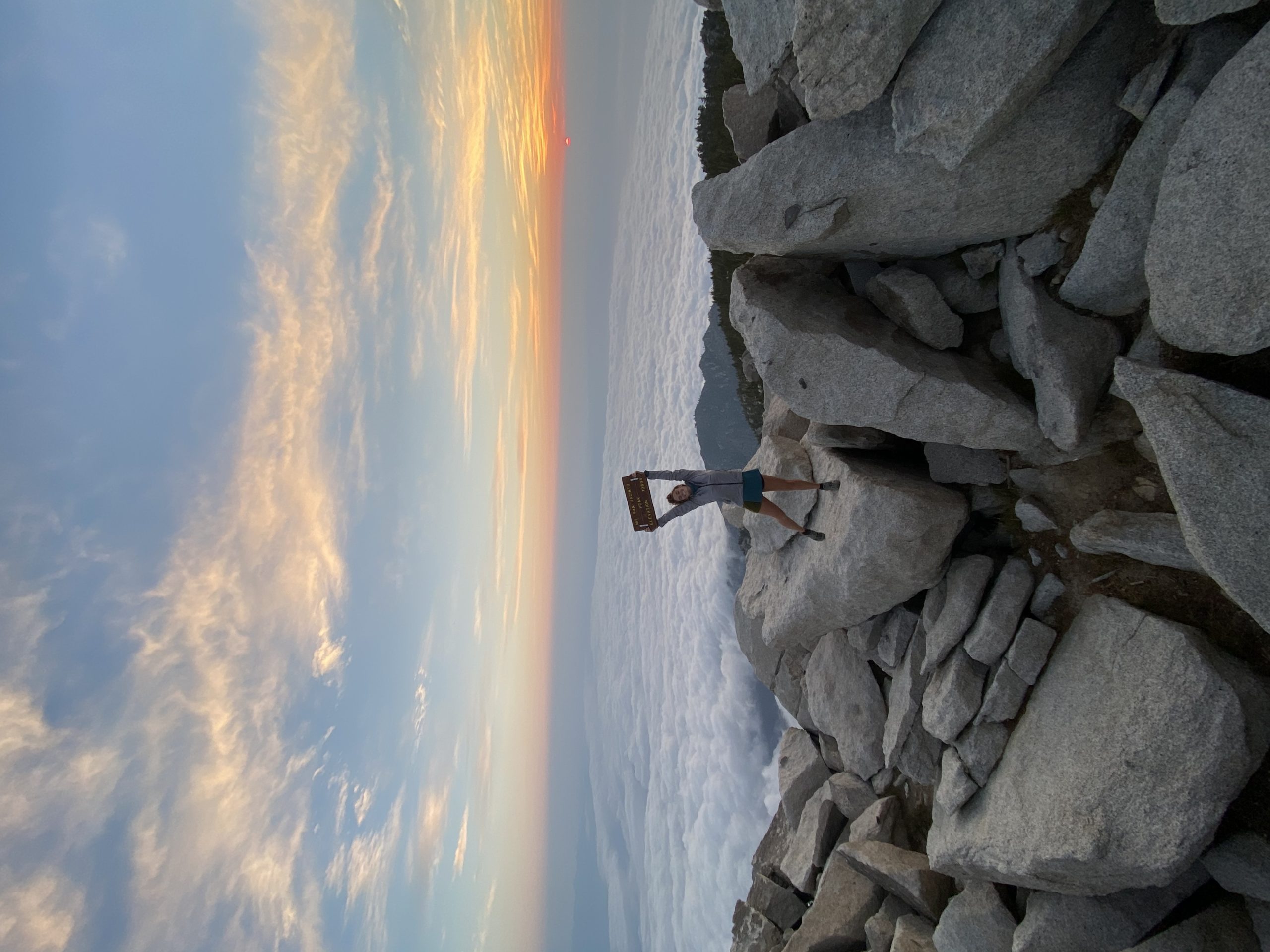
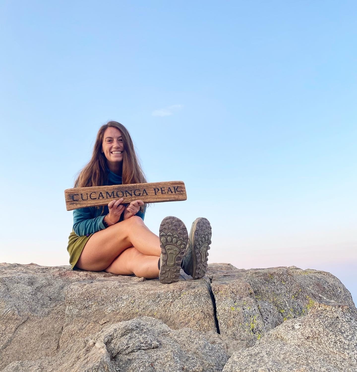
Icehouse Canyon to Cucamonga Peak
Miles: 11.6
Elevation Gain: 4,314 feet
Notes: Forest Adventure Passes are required to park, and self-serve wilderness permits are required to enter Icehouse Canyon. Day hikers flock to this trail.
Highlights: I highly recommend starting this hike for either sunrise or sunset and coming prepared with a headlamp. However, the views on top of Cucamonga are worth it. From the 8,858-f00t peak, all of the Inland Empire to the east and LA County to the west are visible.
Bighorn Peak and Ontario Peak
Miles: 14.5
Elevation Gain: 4,530 feet
Notes: Forest Adventure Passes are required to park and self-serve wilderness permits are required to enter Icehouse Canyon. Though this route follows the popular Icehouse Canyon trail, once you reach the saddle and turn toward Bighorn and Ontario it gets much less crowded.
Highlights: This trail offers epic views of Mount Baldy and the Icehouse Canyon without the throngs of people. There are also flocks of bighorn sheep along these less-traveled trails, an exciting sight in Southern California.
How to Backpack Here

Sunrise on top of Mount Baldy after a night spent on the summit.
This is my favorite area to backpack in Southern California. The logistics are minimal; all you need are self-serve overnight wilderness permits and a Forest Adventure Pass to park. The biggest challenge is determining how much water you will need. To illustrate, for a three-day trip I started off with eight liters of fluids and had one opportunity to refill at the Mount Baldy Notch Restaurant. But hey, can I really complain about some extra weight training?
Because of the difficulties of long water carries, trails often bustling with day hikers clear out overnight. I highly recommend camping on top of one of these mountains. Nothing beats rolling out of your tent and getting a prime sunrise viewing spot before the 2 a.m. day hikers beat you.
Recommended Backpacking Trails
- Old Mount Baldy to Three T’s Loop | 20.3 miles / 8,041 feet elevation gain
- Mt. Baldy: 10 Peaks | 27.5 miles / 11,046 feet elevation gain
- San Antonio Ridge | 22.5 mile / 11,765 feet elevation gain
San Bernardino National Forest and San Gorgonio Wilderness

‘Twas a windy day.
San Gorgonio Mountain, or “Old Greyback,” is the tallest mountain in Southern California. There is no easy route to the summit, and many use this peak as their final training hike before tackling Mount Whitney. San Gorgonio is located in the larger San Bernardino National Forest. The PCT cuts right through here around the town of Big Bear.
Short Day Hikes
Pine Knot Trail to Grand View Point
Miles: 6.9
Elevation Gain: 1,177 feet
Notes: Forest Adventure Passes are required to park. If you’ve got one day to see the best of Big Bear Lake (when it’s not ski season), this is the trail to take.
Highlights: This route switchbacks up through dense forest and lands in an epic clearing with a fantastic view. Both Mount San Gorgonio and Catalina Island are visible on clear days.
Cougar Crest Trail
Miles: 5.3
Elevation Gain: 898 feet
Notes: Forest Adventure Passes are required to park. This short hike is right outside the trail town of Big Bear Lake.
Highlights: Though it’s a bit rocky, it’s a wonderful way to tag the PCT on a short day hike.
Deep Creek Hot Springs Trail
Miles: 3.6
Elevation Gain: 921 feet
Notes: Forest Adventure Passes are NOT required to park. Double-check the directions before blindly following a GPS, because this has been known to lead hikers astray. The hike is downhill to the hot springs, so be sure to pack ample water and snacks to fuel the trek back up.
Highlights: Soaking in any body of water is easily my favorite reward for a hike. Pick a cool fall day and treat yourself to a hot spring adventure. This also makes for a perfect detour after a strenuous summit of San Gorgonio.
Long Day Hikes
Siberia Creek Trail
Miles: 18.8
Elevation Gain: 5,318 feet
Notes: Depending on where you park, you may need an Adventure Pass. There is a ski resort within walking distance from the trail that requires passes, but you may find parking right at the trailhead as well. Wilderness permits are not required.
Highlights: The crowds on this trail are minimal. The creek flows year-round and there is snow in the winter months.
Vivian Creek Trail to San Gorgonio Peak
Miles: 19.0
Elevation Gain: 5,492 feet
Notes: Wilderness permits are required for all overnight hikes, and these must be requested via email. Permits are not required for day hiking, but Forest Adventure Passes are required to park.
Highlights: This is the steepest and most popular route to the top of San Gorgonio. Throughout the 5,000-plus feet of elevation gain, hikers pass through a widely diverse set of landscapes.
South Fork to Dollar Lake
Miles: 11.3
Elevation Gain: 2,900 feet
Notes: Self-serve wilderness permits from the Mill Creek Ranger Station are required for day hikes. You’ll also need a Forest Adventure Pass to park at the trailhead.
Highlights: This trail is a gradual uphill to a stunning lake—something Southern California is definitely lacking in general. With an overnight wilderness permit, this is also a wonderful place for a chill backpacking trip.
How to Backpack Here
Within the San Gorgonio Wilderness, free overnight permits are available. Email this form to the address listed at least five business days before your trip. Instructions and guidelines for campsites are available on this website.
Recommended Backpacking Trails
- San Gorgonio 17 Peaks | 28.8 miles / 8,448 feet elevation gain
- South Fork Trail to San Gorgonio Mountain Via Mine Shaft Saddle | 21.3 miles / 4,678 feet elevation gain
- San Bernardino Nine Peaks Traverse | 25.0 miles / 7,457 feet elevation gain
Note: The Apple Fire has led to the closure of many trails in the San Gorgonio Wilderness. Check here for updates.
Mount Laguna Recreation Area

Ah, Mount Laguna. The first climb of the PCT and a forest-y oasis just an hour east of San Diego. Mount Laguna has many developed campgrounds, dispersed camping options, and trails to peruse among grassy meadows.
Short Day Hikes
Garnet Peak via the PCT
Miles: 4.0
Elevation Gain: 688 feet
Notes: You’ll need a Forest Adventure Pass in order to park here.
Highlights: For a quick jaunt along the PCT with a view of the desert below, Garnet Peak is a great addition to any camping trip.
Sunset Trail to Laguna Meadows Loop
Miles: 8.0
Elevation Gain: 790 feet
Notes: Forest Adventure Passes are required to park. Also, the Sunset Trail is one of the only ones in Laguna that allows bikes. I don’t know about y’all, but I’m not the biggest fan of jumping into bushes to make way for mountain bikers tearing out of control toward me.
Highlights: This trail features the Laguna Lakes.
Monument Peak Trail
Miles: 3.4
Elevation Gain: 616 feet
Notes: Forest Adventure Passes are required to park here.
Highlights: Though the trail is overgrown toward the top of the peak, this short hikes offers epic views of the Anza Borrego desert.
Long Day Hikes
Big Laguna Mountain Loop
Miles: 10.3
Elevation Gain: 1,167 feet
Notes: Forest Adventure Passes are required to park here. During the winter, there may be snow on the ground.
Highlights: This loop is the perfect way to see all Laguna has to offer. It takes you along the PCT, through meadows, next to the Laguna Lakes, and back around through conifer forests.
Big Laguna Trail
Miles: 13.3
Elevation Gain: 1,240 feet
Notes: You’ll need a Forest Adventure Pass in order to park here. Though this is similar to the Laguna Loop, it is NOT the same. Don’t be like me and accidentally turn a 10-mile hike into 16.5. It’s still just as gorgeous, though you may find more bikers.
Highlights: One of Laguna’s highlights, in general, is the gentle elevation gain. This trail is therefore perfect for beginning trail runners, or weighted pack practice in preparation for a longer backpacking trip.
Long Canyon Loop via the PCT
Miles: 17.1
Elevation Gain: 2,398 eeft
Notes: You’ll need a Forest Adventure Pass in order to park here.
Highlights: The seclusion of this trail makes it a wonderful option for some solitude. It’s also great for backpacking, though water is scarce.
How to Backpack Here
Backpackers cannot camp between miles 41 and 52 of the PCT, within Laguna Mountain Recreation Area. This means that you cannot camp along the trail during either a section or thru-hike. However, overnight use is allowed in other parts of the Laguna backcountry away from the PCT. Many of the long day hikes listed above also make for epic overnighters. To get a dispersed camping permit for Cleveland National Forest, either call (619) 445-6235 or visit this site. As always, LNT rules apply.

This website contains affiliate links, which means The Trek may receive a percentage of any product or service you purchase using the links in the articles or advertisements. The buyer pays the same price as they would otherwise, and your purchase helps to support The Trek's ongoing goal to serve you quality backpacking advice and information. Thanks for your support!
To learn more, please visit the About This Site page.
