 ">
">
Completing Southern California
Day 38
Except for our campsites, and getting from/ to them, the day’s terrain was above 8,000 ft. At the first stream, I finished my breakfast oats and chatted with a NoBo gal named Nicole. Several miles later, I filled my two liter bottles and chugged water, preparing for a 15 mile dry stretch. Luckily, it was an overcast day and hence cooler.
Eventually I caught up to Karin and we had lunch on a high point with a view of snow capped peaks. I got really tired afterwards, not physically but mentally from poor sleep the night prior, and stopped to lie on the ground for 20-30 minutes. Karin also stopped to rest. Then the sky darkened and we experienced a monsoon thunderstorm: on & off light raindrops and a rumbling sky.
We did perhaps a mile of descent, a 23.4 mile day, before stopping beside a stream to camp.
Day 39
This morning as I sat on a granite rock and filtered water from a crystalline stream, I felt so happy to be living outdoors. I mean, I’m happy most every day on trail, but it struck so deeply in that moment. I am where I want to be!
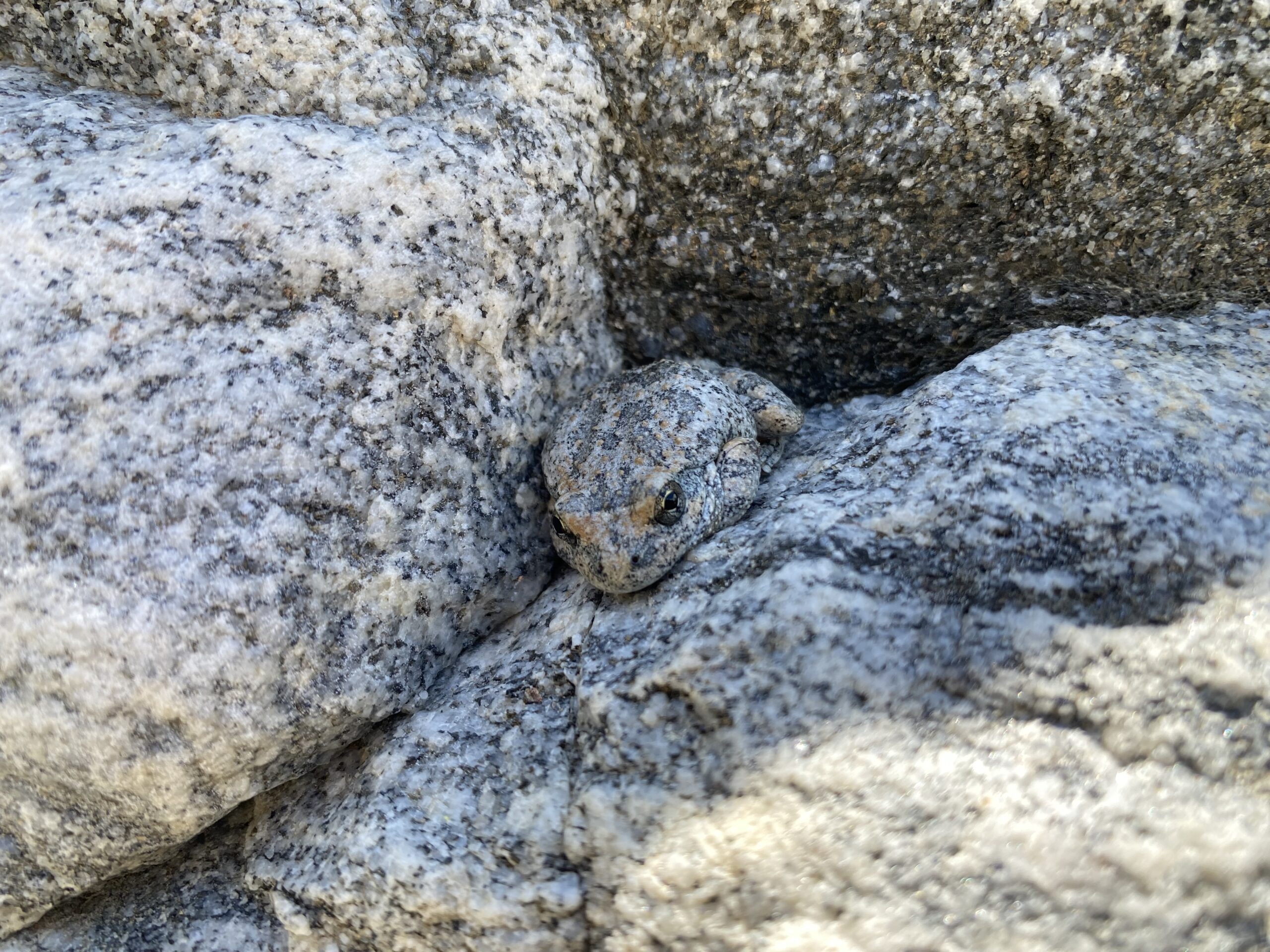
The trail traversed fingerlings of hillside, then it settled on a downward path that intertwined with Mission Creek. The two followed the same valley and most crossings were necessitated by an obstacle such as a cliff. At first the crossings were jumpable, then the creek widened. I turned my pants into shorts and waded across in my socks and shoes. There were at least 20 crossings, however it was a hot day so each immersion felt refreshing and the excess water quickly squished out of my shoes. Usually the water hit me mid-calf. I discovered a couple frogs camouflaged on the side of a boulder.
At the last Mission Creek crossing, I came upon a group of thru hikers, Karin among them, resting in the shade of a tree. I joined them and got out my lunch. While I ate, I chatted with a guy named Tick Shot. Noticing thunderclouds on the horizon, I roused myself and headed uphill. It was hot, however at the top a breeze made the heat more bearable. I met a SoBo section hiker named Anna and as we chatted the next several miles flew by.
Whereas Karin was apprehensive about Fuller Ridge, I was nervous about the Whitewater River, though less so as we got closer and NoBo’s reported an easy crossing. I expected to follow Karin’s lead across, but I didn’t like her route. An island of rock divided the river in two and I crossed there, the current strong yet below my knees. I felt confident after successfully choosing my own path.

We bypassed Whitewater Preserve Campground to make more miles, knocking out a hill climb. At the top, the beautiful light of evening illuminated waving grass and bushes frosted with tiny white flowers. The wind blew fiercely. We found a sandy campsite and Karin held my tent in place until I could stake it.

Day 40
I woke shortly after 2 am, seeing the red light of Karin’s headlamp as she packed up. I put in my earplugs and went back to sleep. At 5 am, I got up and by 6 am I was on trail. After one quick hill, the terrain sloped gently downward. The trail passed a wind farm, skirted Cabazon, and went beneath I-10. It reached a low point of 1200 feet then began to rise. It was another hot day.
After 10 miles, I stopped at a water faucet. I squeezed into the shade of a large rock to filter water and chatted with a couple from Yorkshire. I haven’t mentioned that about half of the hikers I meet are from overseas, mainly Europe. Unfortunately, a lot of them, especially the younger ones, keep to themselves.
I spent the rest of the day ascending the foothills and then slope of Mt. San Jacinto. Due to the heat, I worried that the climb would be grueling. Yet the trail ascended gently via long switchbacks and there was a nice breeze. About 1:30 pm, I came upon Karin curled in the shade under a large rock. We ate lunch and chatted. Then my portion of the shade disappeared and I resumed the climb. For entertainment, I began book one of Rick Riordan’s “Heroes of Olympus”, the followup series to the Percy Jackson books.

It really was a beautiful climb, stunning vistas and lots of flowers, mainly fragrant purple blooms. At dusk, I made camp at 6,400 ft. Karin joined me as I ate dinner. We were at the edge of the tree-line and about three miles from Fuller Ridge.
Day 41
In the wee hours of morning, I woke and realized it was raining lightly so I jumped out of the tent and quickly put on the rain fly (which I’d left off to see the stars). There were flashes of lightning far off. I heard it rain a couple more times. We decided to sleep in and didn’t leave camp until 7 am.
After hiking three miles and gathering snow melt water, Karin & I started Fuller Ridge. It took some meandering before we came upon the NoBo boot track, then we covered about 1/2 mile per hour. It was complete snow cover except where rocks and bushes protruded. We wore our micro-spikes and used our poles heavily. Really it wasn’t as bad as either of us had pictured, no scary drop-offs. I felt we had the advantage as we were going uphill, which made it harder to slip. The snow had give, but wasn’t slushy.
Following 1.5 miles of snow travel, we happily discovered a barren up & down section of ~1 mile. We ate lunch before proceeding into patchy snow. The bare areas were faster walking, however it could be tricky to relocate the boot track. Much sooner than expected the ridge was done. Then the San Jacinto River came roaring down the hillside. The track crossed on a sketchy log approached via a steep snow bank. I did not trust my balance so I went on my knees; Karin did it standing. Our feet were thoroughly soaked by that point.

There were two options, taking the PCT or the alternate route up & down San Jacinto Peak. We decided on the latter and found a good boot track after some trial and error. The route was entirely snow covered, yet not sketchy. Karin and I watched sunset from the top of the peak, at 10,813 feet. It made the entire day worthwhile and we couldn’t have done it without one another’s support. Then we slept on the summit. I was grateful to eat dinner and slip out of wet socks into down booties.

Day 42
Unfortunately I slept terribly, not sure why. On the plus side it was a beautiful, sunny morning with blue skies. The first section of boot track took us straight down the mountain. I didn’t mind the exposure; Karin found it scary, but powered through. Soon the trail leveled out into a forested area and there were occasional bare patches of dirt and stream. In less than five miles, we rejoined the PCT.
A short time later, a group of five NoBo’s approached and I spotted Debbie amongst them. I yelled “Debbie” and ran towards her. She spotted me and ran forward; we met in a big hug! It was so good to see her again. The three of us did a quick catch-up and then Karin and I informed her group on conditions ahead.

The sky had been darkening for some time. Soon a spattering of rain drops begin to fall so I suited up in my rain jacket and pack cover. When it began to pour and hail, I paused under a pine tree thick with needles and ate a snack. Karin joined me, umbrella in hand. Once the precipitation lightened back to rain, we resumed walking. We met a park ranger who didn’t check our permits due to the rain.
We ate lunch and got water at Tahquitz Creek, chatting with a large group of hikers. A man named Endgame gave me a handful of snow peas. For another hour, we walked through continuous and then patchy snow. It gradually disappeared and we happily removed our micro spikes! The trail rounded a corner, offering a view of Palm Springs. There was a last stream of snow melt where we topped off our three liters apiece.

After crossing deadfall and a rock slide area, we found a beautiful camp site. Budding bushes surrounded a flat, soft spot of dirt with hammock potential nearby. I was losing steam and went to sleep shortly after dinner.
Day 43
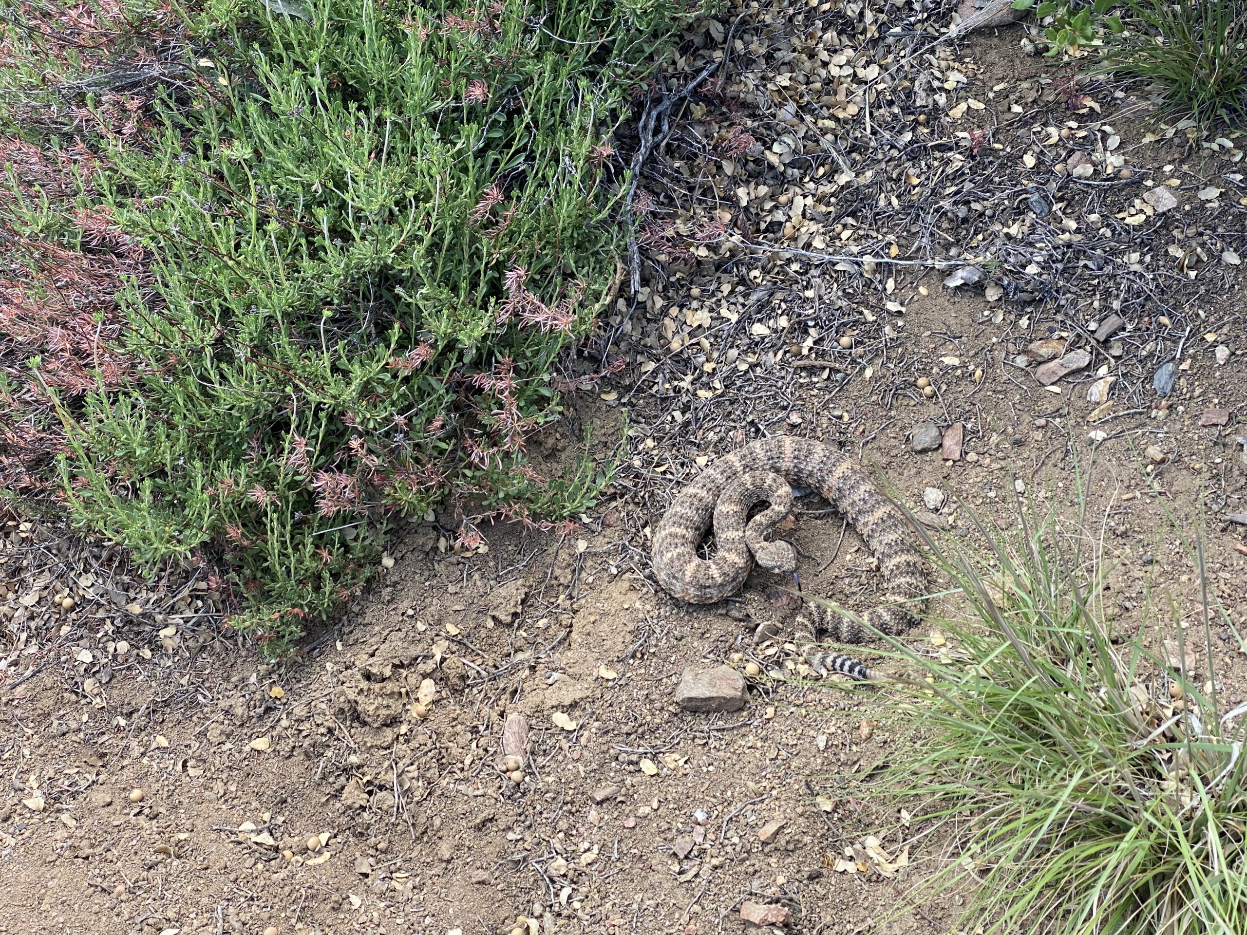
What a great night’s sleep! Refreshed and with a light pack, I charged uphill. The trail took me around Apache and Spitler Peaks, dropped down, and climbed a peak dotted with pines. On the following ridgeline, I startled a rattlesnake. It rattled at me then coiled into a protective position. I edged by, excited to have seen it! Earlier I saw a small garter snake and a large brown snake.
About four miles from the highway, I came across pools of water in a slow flowing creek. I immediately scooped, filtered, and drank 1/2 liter, getting more to carry. Then it started to rain so I put on my gear. It came down pretty hard and I kept hiking. Eventually I did stop under a tree, my pants soaked, to watch the rain. I’ve been eager to finish this section of trail, but I felt a sudden pang of sadness at saying goodbye to the desert. When the rain stopped, reminders lingered everywhere. Water pooled in rocky crevices, ran in a small stream down the trail, and glittered in bushes like small gems.

At the highway, Karin and I finished the Southern California section of the PCT, 653 miles from Campo to Walker Pass! We walked a mile down the road. Unfortunately the Paradise Valley Cafe was closed, but we each had one dinner left. We went to Richard’s house across the street. I pitched my tent in his yard. Sitting to remove my damp shoes, I saw his golden chicken use a potted plant to fly atop the fence and escape. I told Richard and he moved the plant. Karin and I chatted with a half dozen other hikers and did laundry.

This website contains affiliate links, which means The Trek may receive a percentage of any product or service you purchase using the links in the articles or advertisements. The buyer pays the same price as they would otherwise, and your purchase helps to support The Trek's ongoing goal to serve you quality backpacking advice and information. Thanks for your support!
To learn more, please visit the About This Site page.

Comments 1