 ">
">
Day 14: Baby’s First Snow Hike (aka, Oh. My. God)
The story of our 14th day on trail actually starts the night before. Let‘s set the scene:
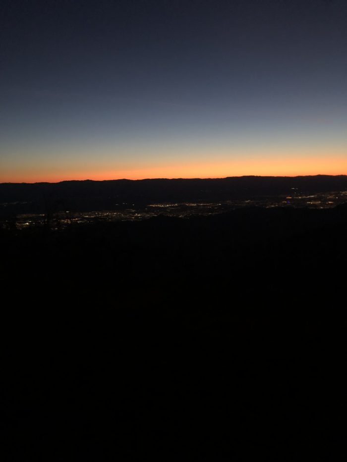
It’s 7 p.m. The sun is setting softly, casting a beautiful golden glow over the Fobes Ranch Junction where we, meaning Choker, Vitamin P, Mango, me, and several other hikers, have set up camp for the evening. The air is still and surprisingly warm. San Jacinto looms in the not-so-far distance. Today’s 15 miles were the first time on trail that we could actively see our destination as we walked.
10 a.m: That’s… not where we’re going… is it?

7 p.m.: Holy shit. We actually walked here.

The 15 miles up to our campsite were just that—up. It felt like we chugged the whole way. I actually resorted to playing one of my favorite games: how many miles will it take to memorize this song? (“Semi-Charmed Life,” Third Eye Blind, less than three miles.)
By the time I get to Fobes, I am just about done with everything. Choker, Vitamin, and I had lost the trail a few hours back and ended up doing a bonus mile, rewarded with a gratuitous break, obviously. When we all finally wander into camp, poor Mango is the bearer of bad news: “So, uh… if we wanna summit San Jacinto, tomorrow’s actually the day.”
Oh. OK.
I’ve always planned on summiting San Jacinto. Although not technically a part of the PCT, it’s the first major peak the the trail passes by. I had grand visions of summiting at dawn or staying the night in the cabin near the peak. I had dreams! I had ideas!
I, nor the rest of my crew apparently, actually had a plan however.
The problem basically came down to food and housing. We each only had a half day of food left, having anticipated arriving in Idyllwild the next afternoon, and we already had a cabin booked for the night. It would be 13 miles from Fobes Junction to Saddle Junction, where we would then meet up with the San Jacinto Peak Trail. It’s only two miles up and two miles down, but you gain something like 5,000 feet in those two miles. And then it’s still 2.5 miles down the Devils Side Trail to the parking lot to pray for a hitch into town.
Damn.
Mango calls a friend back home, hoping to sort out some logistics to make this possible. Maybe we could take a tram down the other side? There’s a restaurant there, right?
Nope. Not possible.
Then there’s the other issue, the one which had actually forced us off the trail and into town the day before. Day 14 is the day we’re finally going to hit snow, and reviews are mixed about exactly how much of a shit show it’s going to be. We’d opted in town due to the rain, afraid the ridges would be too icy in the aftermath, but now it’s time. Our spikes are ready, we have no idea what to expect, and damn it we also want to summit San Jacinto!
Choker and Vitamin P quickly bail when we realize that attempting both routes will probably require a massively early start, but Mango and I are gung-ho enough (read: stupid enough) to decide to wake up at 4 a.m. Better to hit the snow when it’s hard anyway, right?
Everything just seemed so doable in that 7 p.m. sunset.
Day 14: Showtime
My alarm goes off at 4:15, and for once I actually spring out of my bag. I’m normally easy to rise, but I’ve had some problems on trail due to the cold. Not today. I can hear movement all around me, but I’m not sure if it’s the wind or Mango rustling awake in his tent. I refuse to break down camp without making sure he’s actually still on board with this plan, so there’s only one thing to do.
I strap on my headlamp, turn the light to red, crawl over to the mesh door of his tent, and whisper as tactfully as possible, “Are you awake?”
To which he obviously shout-jumps, terrified at the red demon whispering into his tent at 4 a.m.
“Sorry!”
After a little debating and “But it’s cold. It’s windy. It’s dark,” Mango finally gets up and we begin to break down our tents by the light of the moon.

We hit the trail a little before 5, and within the first 15 minutes I’m already thinking to myself, “This might have been a mistake.”
The route is just as steep as it was the day before, and we immediately hit blown down trees and washed-out trail. Still, we soldier on, up and up and up and over that huge-ass log and up and up and around this fallen limb and…
The sunrise makes up for some of the hassle. It’s orange and lovely and absolutely unphotographable.
We stop to take some pictures anyway, and when we go to continue we suddenly realize—there’s no trail.
What?
Guthook (the GPS app hikers use) tells us that the trail is somewhere up above us. We’re far off. How?
Did we miss a switchback? We starting trying to push back to it, which ends with some scrambling, a lot of cursing, some GPS consulting, and some guilty switchback cutting as we try to double back. This part of the trail was severely impacted by a forest fire and flood in the past year, and it’s really no joke how easy it is to lose it. When we finally find ourselves, Mango doubles back to make an arrow out of sticks to help other hikers find the way.
Phew.
We push on another half mile until the sun is all but risen. Unbelievably, we’ve only gone two miles. “I wonder when we’ll hit the snow?” I ask, disheartened. And that’s when Mango realizes the worst: he’s lost a crampon somewhere along the way.
Should he go back? Should we push on? Can he make it without any sort of spike?
Ultimately, he decides to trail run it back while I bag babysit. Fine by me! I have service, so I make some coffee and bask in the sunrise. Niiiice.

An hour or so later, I hear the telltale clack of trekking poles and from around the bend comes Mango, crampon in hand—and Vitamin P!
Mango is carrying Vitamin’s pack, which is easily a third of the size and weight of his own monstrous camera-gear heavy bag. “He said that wearing it makes him feel like a preschooler!” she pouts. If she weren’t already Vitamin P, pre-K would have been a preeeetty good trail name.
Onward-ho we go! Sure, it’s a bummer that we made such slow progress this morning and then lost even more time because of the missing crampon, but that’s OK. The trail has a mind of its own. Can’t fight it. Can’t complain.
It’s not long before we run into the first patch of snow.

“That’s it?” Vitamin says.
“Do we even need to use the spikes?”
We finally decide to put them on, better safe than sorry. If we’re carrying them, might as well use them.
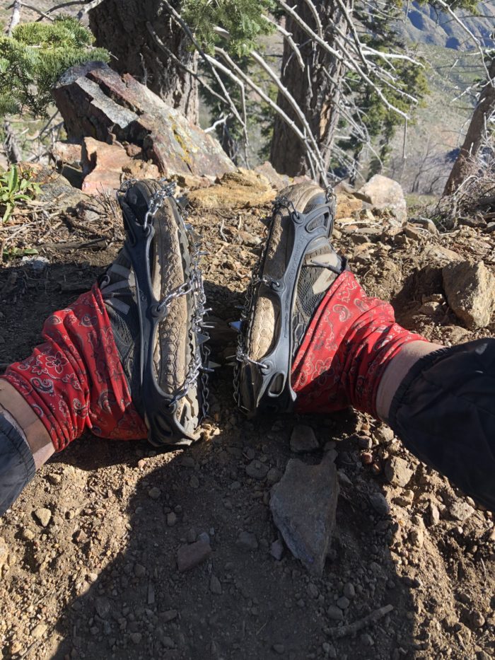
No big deal! It’s a strange sensation, but the spikes make me feel surprisingly secure on the angle. We take them off once we can see that it’s clear around the bend, but it’s not long before we come across the next patch of snow.

It looks fine. It looks easy.
“I’m just gonna go for it,” I tell Mango. He hesitates, and in the meantime a hiker that we have never met before comes trotting up. “We’re debating whether to put the spikes on,” I tell him.
“Oh, I don’t have any.”
Off he goes. He’s fine! “I’m not putting mine on,” I repeat.
And then the new hiker slips.
He recovers in time, catching himself with his hand and a pole, but it’s a steep slope down and both Mango and I audibly gasp.
The hiker quickly rights himself and scurries away.
Mango and I both put on our spikes.
The rest of the afternoon is great for me. It’s day 14, the supposed end of the break-in period, and I finally feel the beginnings of my hiker legs. It helps, of course, that I’m only carrying a half day of food and a liter and a half of water, but I feel like I’m flying up the slopes, fueled by Taylor Swift and Eric Clapton. I cross a third snow patch, spikes on, with no problems.
By 11 a.m., there are only about six miles left in the day. Two to a creek, two up to Saddle Junction, and two down to the parking lot where we’ll hitch out. I’m feeling good, so I take a bit of a break by a small water source, waiting for any of my crew to meet me so we can head on together. When Mango comes along, we head off together and he jokes that my trail name should be Energizer because the moment I put on my headphones I’m like the Energizer Bunny.
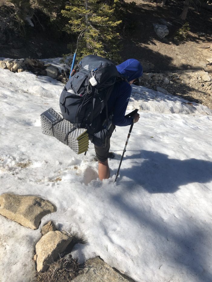
We’re having a great time, laughing and huffing up the hills, when suddenly the trail transitions from dirt to pure snow. No more patches of ice; it’s snow all around us.

And it’s fun! The snow is a little slushy since it’s now around noon, but firm enough to keep from postholing (sinking down) too far.
However, our speed slows a good amount, and the longer we’re on the snow, the softer it gets and the more tired we become. Those two miles to the creek take us almost two hours. I fall once, sliding down a gentle slope into some rock on my butt. Mango’s camera actually slides down a small slope, as well.
The thing about hiking on snow is it feels like every step takes twice as much energy. You have to step, test, maybe sink, push your poles forward (they’ll definitely sink), pull out the poles, pull your foot out of the snow to some degree, and repeat.
My ankles and butt are frozen from snow, but my face and torso are soaked with sweat.
We make it to the creek, which is still covered by a winter snow bridge, and Vitamin P and Choker catch up to us before long.

We take a nice break, wildly tired for having only gone two miles since our last break, and finally Choker announces she’s going to head on before us. Another hiker we’d just met, Happy Feet, goes on with her, leaving Vitamin, Mango, and me to rally the energy to continue on. If it isn’t clear by now, summiting San Jacinto is absolutely out of the question.
When we finally get ourselves up, we follow in the direction of Choker, Happy Feet, and all the hikers to have come before them this season. So far, the trail has been completely covered by snow but also still clearly noted thanks to the footprints leading the way. It hasn’t really been so different, route wise, from any other day.
Too soon after starting, I check the Guthook GPS, already dying to know how much longer we have until the junction. But when I look, we’re not on the trail. We’re not even close to the trail!
I stop Mango and Vitamin, and they check their phones as well. Sure enough, the footprints we have been following have led us off the trail. From what we can determine, it looks like they’re trying to cut across a large bend, totally missing about a mile and a half of the PCT.
I, for one, am not only a rule follower but also a large baby. I’m too stubborn and nervous to veer off track. I immediately start trying to get us back to the trail.
Mango is game as well, and together we use Guthook and his Garmin GPS watch to try to figure out where we are in relation to the PCT and the best way back.
It’s actually a lot of fun at first. We walk through unbroken snow and cut some switchbacks and generally go on what feels like a cross-country adventure. Vitamin P is less than thrilled by this turn of events—it’s a lot harder to go across unbroken snow than follow tracks—but she follows along as well.
To be clear, when I’d decided to try to get back to the PCT, I’d done so under the impression that we’d merely missed the correct set of footprints and followed along a side trail. I was positive we’d link back up with the obvious trail in no time.
Wrong.
As I lay here in my tent in Idyllwild on day 15, I’m still not entirely sure what happened. All Mango, Vitamin, and I can assume is that no one else yet this season correctly followed the PCT from mile 177 to 179. That sounds ridiculous. It’s April 19, and dozens of our friends went ahead before us. Surely someone else realized they were off trail before and had tried to correct?
There were no marks. There was no trail. Route-finding, eyes glued to the map, was fun for about a half mile, but it quickly became exhausting as we realized that the trail was winding up the hill, and we had to try to approximate the same in what was now thoroughly slushy, posthole-perfect snow.
At one point, dirt trail appeared! Vitamin and I prematurely celebrated by taking off our micro spikes, which were incredibly tight and pinchy on our feet. However, the snow quickly resumed and we were back to route finding. Feet sore and tired from the spikes, we both tried to soldier on without them. Within about ten minutes we’d both fallen and slid twice. The bruises on my butt are actually impressive, but at the time all I could think was, If this is how bad the desert snow is, how am I ever going to be able to manage the Sierra??
So back on went the spikes, Mango laughing at us for having been so naive as to take them off, and on went the misery.
In the words of poor Vitamin P, who actually broke into tears at one point from exhaustion and frustration, “The lack of footsteps was so ominous! There had to be a reason no one was taking the PCT through this patch! All I could think was, what the hell are we doing?”

But there was nothing else to do but go on.
Mango took the lead, digging deep holes with his more industrious crampons. Sometimes too deep.
My knee was howling in pain. Walking in snow is so much more repetitive than walking on dirt, and there were several moments I just had to grit my teeth and carry on.
Two and a half hours. Two and a half hours for 2.2 miles.
When we finally reached Saddle Junction, Choker was nowhere to be found. We assumed (hoped) she must have arrived ages ago and already started the side trail down to the lot, but there was no way to tell without cell service.
It was getting close to 5, and we still had 2.5 more miles and a hitch to somehow catch. No one dared voice the question lingering in our heads—What if there’s no one in the lot to hitch with? What if there’s no service down there? We had the phone number of one trail angel, but what if…?
Exhausted, sore, feet frozen and blisters forming, we took a short two-minute break and began the descent to the lot. Thankfully, we ran into Choker about halfway down. She’d waited for us at the junction, but ultimately gave up, thinking that we’d gotten as lost as her and Happy Feet!
Turns out the original footprints led to nowhere. They’d had to go cross-country too, only they’d decided to ignore any hope of finding the PCT and made a beeline straight for the junction. “Miserable,” Choker informed us. “What a fucking joke.”
A bad afternoon all around then.
With less than a mile to the lot, I plugged in my headphones and lived up to the theoretical trail name of Energizer, letting the band Bleachers inject me with just enough dopamine to all but sprint to the bottom. Where, of course, none of us had service.
So then came the song and dance of wandering around the parking lot, phones in the air frantically searching for a bar or two, the parking lot otherwise devoid of life. Vitamin clocked a call after about 20 minutes, and just like that, trail angel David was on his way in his Jeep to come get us!
David is the definition of a trail angel. No questions asked, he told Vitamin, “Where you at? Just let me put my shoes on,” and immediately drove up into the park to come get us. He said he grabs hikers whenever they call and urged us to give his number out to others, just as Happy Feet had given his number to us. He refused any payment and only asked that we pay his kindness forward to other hikers by buying them breakfast or dinner sometime. Now, I have a photo with David, but he asked me not to post it. I want to keep it as a memory of how incredibly, insanely kind people can be.
He dropped us off at the restaurant Ferro in Idyllwild, where we gorged ourselves on nachos and burgers and beer and salad and cookies, slightly stunned by the turn of the day, but already laughing it off. Who would have thought that four miles could be harder than the whole rest of the trail combined?
We ran into a few other friends in the restaurant who all agreed the same thing—the snow was fun, but passing the creek was confusing. It seems like most people went straight up the hill? Honestly, I don’t even know.
We ended the day by forcing ourselves to ask a random dude at a gas station if he would drive us back to our previously booked cottage, too tired to walk even a single mile more. He immediately agreed, but wasn’t much of a talker on the way.
When we finally made it back into the cottage, ready to shower and pass out immediately, we were greeted by the best of luck: no hot water.

This website contains affiliate links, which means The Trek may receive a percentage of any product or service you purchase using the links in the articles or advertisements. The buyer pays the same price as they would otherwise, and your purchase helps to support The Trek's ongoing goal to serve you quality backpacking advice and information. Thanks for your support!
To learn more, please visit the About This Site page.

Comments 3
I would say a Hell of a PCT hiker.
Wow! Hell of a day! Thanks for all the detail and good luck in the days to come!
I enjoy your writing! My son started in Campo 5-9 and your descriptions make the trail come to life!