 ">
">
North Cascades Glory: PCT Part 2
AUTHOR’S NOTE: I wrote most of this post in Bellingham last weekend, but didn’t have time to finish and post it. Sorry for the delay! Also, please click on the images to see them full size. I think they’re worth it!
When last I left you I was headed back up to Rainy Pass to begin a seven day stretch down to Steven’s Pass. I had been warned that this section was difficult even on dirt trails, and based on my experience I didn’t figure I’d have much dirt.
It was hard.
There was very little dirt.
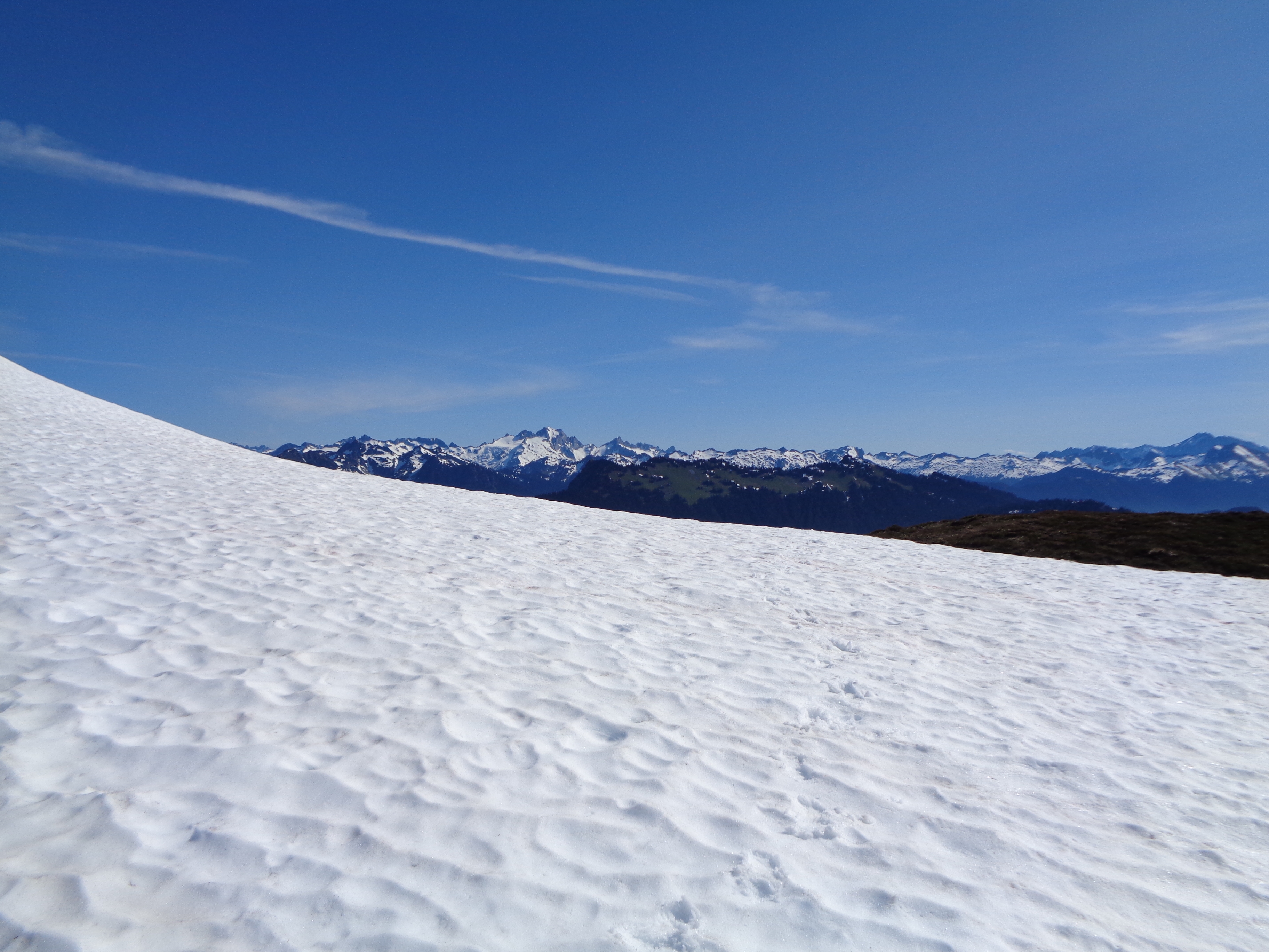
Snow, snow, and snow. Did I mention I hiked on a lot of snow?
My trip so far
The Pacific Crest Trail has been an indescribably amazingly good thing for me in my first three weeks. I have been challenged by miles upon miles of snow covered trails, navigating out of passes still buried under 15 feet of snow, fording swollen creeks, and just finding a dry place to camp for the night. I have been rewarded with quality wildlife sightings, endless vistas of some of Northern Washington’s most famous peaks, and several of the most amazing campsites I have ever been to.
I’ve been on trail for 20 days, though only really 18 of those have been on the PCT. I’ve made a bit over 260 PCT miles in that time, having arrived in Snoqualmie Pass yesterday afternoon. Through all of the navigation problems, slogging across melting snowfields, self-arrests (yes, multiple), and grinding full 12+ hour days just to get in 15 miles, I am happy. In each moment, I feel confident and strong, excited to see what lies ahead of me down the trail. All I want to do is hike, forever and ever. Where I am is exactly where I’m supposed to be.
But y’all, the PCT is fucking hard. I’ve met a few past PCT thru hikers along my way, and they’ve asked me how it stacks up to my experience on the AT. PERSONALLY my experience has been that my first three weeks on the AT were significantly easier than my time so far on the PCT. Obviously the snow has been a significant factor in that, requiring more technical skills than just a dirt path in the woods. And maybe time has dulled some of the pains of starting my first thru hike in Maine, but this time around it just feels that everything takes a bit more effort. And I’m loving it.

Even this bridge is like “Fuck, this trail is hard”
Rainy Pass to Steven’s Pass
Somehow I made it through this section in seven days. If I had had more food, I might have stretched it to eight. Much of this section runs through the Glacier Peak Wilderness, featuring traverses along some of the steepest mountainsides I’ve seen, lots of wet creek crossings, and many seemingly forgotten miles of trail, covered in thick plant growth and blowdowns. But holy shit was it stunningly beautiful. I spent nearly three days rounding Glacier Peak itself, and each pass offered uninterrupted panoramas of my surroundings. Finally, nearing Steven’s Pass, I began to see more recreational hikers and even some bona-fide HikerTrash too!
The first day was a welcome treat, 20 miles following a river down from Rainy Pass to the High Bridge Ranger Station. I encountered no snow, and it felt great to put in my first 20 mile day.

Literally skipping through fields of wildflowers
Unfortunately, I missed the last shuttle into Stehekin by about 30 minutes. Though I hear the baked goods are to die for, I had no real reason to visit Stehekin so I didn’t wait around for the morning shuttle and just got on my way. From High Bridge, I finally began ascending into the Glacier Peak Wilderness. I hiked through groves of Cedar trees and Trilliums, my favorite flower, for much of the morning.
 Snack break in a grove of huge cedars!
Just after lunch, I was confronted with a ford of the South Fork Agnes Creek. The trail crossing was very obviously not an option, so I went looking for a safer location. Upstream a ways I found some calmer water, though even this looked to be not ideal. After scouting my line and getting prepared, I aborted two separate attempts to ford here after getting in well above my knees in just a few small steps. Then I looked downstream, and found a safe way to cross balancing atop a series of trees that had fallen across the river.
That night I found my intended campsite buried in snow. Too tired to continue, I poked about and finally found a relatively ground-sheet sized and shaped patch of dirt to call home. This set me up well to cross Suiattle Pass the next morning.

Glacier Peak, from Suiattle Pass
From there, I descended to the Suiattle River, which luckily has a bridge. Just south of that bridge, the trail passes through the Grove of Giants, a stand of old growth Cedar and Hemlocks that absolutely took my breath away. I mean, these trees are friggin MASSIVE. Leaving the grove, I begin to see signs of human activity, including recent trail work. And then, there they are: The North 350 Blades. This PCTA crew was clearing trail starting at the Suiattle River and working south.

Some of the North 350 Blades crew
They must pack in all of their own tools and do the work without power tools. They were the first crew in to start clearing a stretch of trail that has been neglected for the last 15 years due to backcountry roads washing out and making that stretch nearly unreachable for crews. If you’re coming through that area after reading this, give them a HUGE thanks. They totally deserve it.

Looking back at the Descent From Hell
I now started rounding Glacier Peak. On the descent to Milk Creek, the trail has been nearly erased by the amount of plants growing in and over the trail. Many times the trail seems to fall off the side of the mountain from erosion. I am hopeful that the Blades or another crew can address this soon, it seems quite hazardous. On my way back up to camp at Micah Lake, I found snow earlier than expected.

A very frozen Micah Lake
Once again, I scrounged around and finally found some dirt to fall asleep on. The next morning I climbed Fire Creek Pass without the use of navigation tools, just aiming for the low point and going for it. Very near the top, I felt the step under my right foot collapse and I started sliding down the slope. Before gaining much speed, I hit a patch of plants that had just started to poke up and stopped. Thanking my lucky stars, I regained composure and got to the top. I was floored by the view of snow capped, jagged mountains all around me and Glacier Peak looming silently above.

View from Fire Creek Pass, looking south
Lower down, I walked through miles of forest where I’m pretty sure they filmed all of the Endor speeder chase scenes from Star Wars VI. That night, I found the most amazing campsite I have ever slept in. Period. A nice big patch of flat dirt with a fire ring, watched over by a snowy ravine near Red Pass. I’ll let the picture do the talking.

Preach!
Red Pass first thing in the morning was a treat. No trouble getting up there, and it offered me my first view of Mt Rainier! After a sometimes technical traverse to White Pass, the rest of the day was a fight for each and every mile. I did get some magic in White Pass, where one member of a mountaineering party had stayed behind due to illness and gave me some of their food. Most of the rest of the day I spent navigating along steep snowy traverses, which has become my least favorite style of PCT hiking so far. In the afternoon, I had to self-arrest twice as the snow got softer and less stable. Finding the trail was a chore in itself. Exhausted at the end of the day, I slept on a very uneven patch of dirt near some water. I felt like I hardly even knew what dirt was at that point.
This was my low point. I was on edge from all of the snow travel and route finding, and feeling frustrated that a 15 mile day had taken 13 hours. But I learned a good lesson about this low point. All day, I had kept telling myself “Just get around the next corner, and the snow will end,” which is of course an absurd thing to say for an entire day. When the snow didn’t end, I would have a little fit inside and get down mentally.

I turned a corner, and guess what? MORE SNOW!
The next day, I woke up and just prepared myself to be on snow all day. That way, only pleasant surprises! Until I got lost, of course. Just south of Pear Lake, in some thick woods, I missed a turn under the snow and ended up about a quarter mile downhill from where I should have been. I got back to where I left the trail, but had no end of difficulty finding where it actually went from there. After about 30 minutes consulting map, phone, and a lengthy strong if cuss words, I was finally back on my way.
I ate lunch then began ascending through decreasing snow up to Grizzly Peak. I turned a corner and found two hikers taking a break. One of them jumped up and said “Are you Righteous!?!” Forest Ninja had hiked NOBO last year but missed the Steven’s Pass to Stehekin section due to weather, and she and Faceplant were back to finish it off. She had been following me for trail condition updates, and it was kinda weird to meet someone who knows me from the internet, but it was really fun to meet them.

View from Grizzly Peak, looking back at Glacier Peak
From there, I summited Grizzly Peak and got fantastic views. Walking was much easier now that I had tracks to follow. I was feeling good after having some company and getting into less and less snow. Made camp at Lake Janus that night, and prepared for the 10 mile run to town.
I got up early with a mission: food and beer in hand by noon. I set off through the forest and admittedly kind of tuned everything out. As I approached the gap, I crossed more and more day hikers. Then, I saw a pair who had “the look”. They were Gilmore and Morrel, who hooked the AT SOBO last year and are out for the PCT this year. They’re doing Steven’s Pass to Manning, then flipping back to Steven’s and headed south for the rest. All excited for their first day, I left them with visions of hops floating in front of my eyes.
Steven’s Pass
The restaurant at the Pass was open, and I immediately set to work, wet shoes and all. I picked up some snacks at the little shop and set about thumbing. I only waited about 5 minutes before a mother and daughter picked me up right out of the parking lot and took me down to stay at the Dinsmore’s Hiker Haven, a familiar and comfortable feeling hiker dorm. The Dinsmore’s are incredibly welcoming, and I had showered and changed into loaner clothes with laundry going in no time. Before sitting down to watch Mad Max, Andrea bestowed me with my official Class of 2017 PCT Hiker bandana. It might not seem like much, but I felt very honored.
I passed the day reorganizing, cleaning, and resting in the dorm. Chatted for a while with the caretaker Whistler, PCT NOBO 2015. For dinner, the Dinsmore’s cooked up burgers and dogs with ample sides of potato salad and pickled eggs. I’ll spare the exact numbers, but given that I was the only hiker there let’s just say I ate my fill.
My aunt and uncle came down from Bellingham the next morning. My uncle would join me from Steven’s Pass from Snoqualmie Pass, and my aunt came armed to the teeth with trail magic! After getting breakfast and breaking down my resupply box in Skykomish, we headed back to the Pass. There, I gorged on fresh lettuce, a sandwich, chips, beer, and topped it off with amazing homemade chocolate cake with raspberries from their garden. Amazing!
Steven’s Pass to Snoqualmie Pass
As if by magic, the snow had disappeared. As my uncle and I topped the ski area, the mountains around us were all green, with a few flecks of white scattered here and there. I was beaming.
Mig Lake Sunset
We entered the Alpine Lakes Wilderness, and camped at Mig Lake. As the sun began to set, we were joined by Dairy Queen, a 2016 NOBO, who was out redoing the Snoqualmie to Steven’s section. The conversation quickly covered the usual thru hiker topics, and he asked me lots of questions about the AT. I didn’t realize how late it had gotten until I had to turn on my headlamp, which I have hardly needed to do at all yet.
Climbing Piper Pass, covered in all the wildflowers
The next morning we hiked over Trap Pass and then up to Piper Pass. Piper was a lot of steep switchbacks, but incredibly beautiful. The bottom is this beautiful little bowl, and as you ascending you hike through wildflowers and get excellent views back to Glacier Peak. We ate lunch at the top then began a long, slow descent with views of our night’s destination, Cathedral Rock. There was one ford that took a bit of thinking, but we both made it across safely.

Now this is a church I can get down with!
I have been continually amazed by the campsites on this trail. We watched an amazing sunset, and enjoyed soft early morning light as we got on the trail. Climbed to Cathedral Pass and got an even better view of this impressive rock outcropping. We descended past Deep Lake and ate lunch trailside in the woods. In the afternoon we switched from lofty, arid forest to thick, lush, and wet forest just by turning to a different face of the mountain. We crossed the Waptus River and made our way up to a small campsite overlooking the valley.
Ugh waking up is so hard, y’all…
I woke early and watched the sunrise. Not long after we started hiking, we were rewarded with views of Rainier, looming larger each day. We walked through a burn area before the long, six mile switchback descent to Lemah Meadow. Then, after lunch, it was right back up! We ran into many day hikers and some weekend warriors going up to Spectacle Lake. The climb was a long one through a burn, and the sun beating down on us made it a very strenuous climb. On the way up I stopped to help a backpacker who was developing cramps, and gave him some of my electrolyte mix.
We camped at Park Lakes, yet another fantastic site. At this point, my uncle was very footsore, but the today was 14 miles away and we were headed out the next day. I watched another beautiful sunrise, and then we were on our way.

Chikamin Ridge Traverse
Rainier was prominent all morning as we traversed the Chikamin Ridge. There was still snow in a few chutes, and I finally grabbed my ice ax for the first time since before Steven’s Pass. We continued on around Joe Lake and up to Alaska Mountain, the whole time with beautiful views of the lake or Rainier. We navigated a bit more snow, then paused for lunch about 7 miles from the road. We were already late for the arranged pickup, so I was basically instructed to haul ass down the mountain to meet my aunt.
Before I split, I bestowed my uncle with a trail name. He is now “Uppins,” a term he uses to refer to elevation. Example: “I hope we don’t lose too many Uppins on our way through this bowl, I’m really done climbing for the day.”
It was fun jogging past the day hikers, leaving them a bit confused as to what exactly this filthy, hairy creature caring a pack was doing.
And then, there it was. The glorious parking lot. My aunt was waiting patiently with her book, and quickly began showering me with snacks as I got unpacked. About an hour later, Uppins arrived and we set off back to Bellingham.
Part 3 coming soon!

This website contains affiliate links, which means The Trek may receive a percentage of any product or service you purchase using the links in the articles or advertisements. The buyer pays the same price as they would otherwise, and your purchase helps to support The Trek's ongoing goal to serve you quality backpacking advice and information. Thanks for your support!
To learn more, please visit the About This Site page.
