 ">
">
Palmetto Trail Day 17 – Croft Passage with Missing Bridge
After spending three days walking pavement, it is nice to get back into the woods. The Croft Passage is entirely in Croft State Park. This area used to be an Army training area during WWII. At the trailhead is a sign to stay on trail because of unexploded munitions possible off trail. On top of that is a notice that certain trails are closed due to current activities in clearing areas of possible munitions. The closed areas do not seem to be a problem for the Palmetto Trail. Everytime I arrive at an area that’s closed the trail goes the opposite direction.

Most of the day is a nice soft dirt trail with a massive amount of pine needles. About four miles in I come upon a couple lakes. There are people fishing and across the way I can see a parking area and picnic tables. Occasionally there is a hill to climb, but for the most part it’s not to bad at all. Just about every creek has a bridge to cross. The State Park is not very big, but the trail ensures it winds its way around every corner it can. Periodically there is an intersection with another trail which includes a picnic table and a map of the trails.

At the end Southern end of the Park is the Ranger Station. I check in here and stay at the primitive camping site. Turns out that more thunderstorms are expected this evening. There are other campers in the area and stables for those who bring horses.
The storms the night before ended up blowing by. Heard the thunder but do not recall much wind and just a small amount of rain. After a quick breakfast packed up and went South the final mile of the Passage. Going by a kiosk there was a sign stating that a bridge over the creek has been washed out. For more info talk to the rangers on getting around. Nothing g was said to me when I checked in and talked about the trail, so I did not think anything about it.

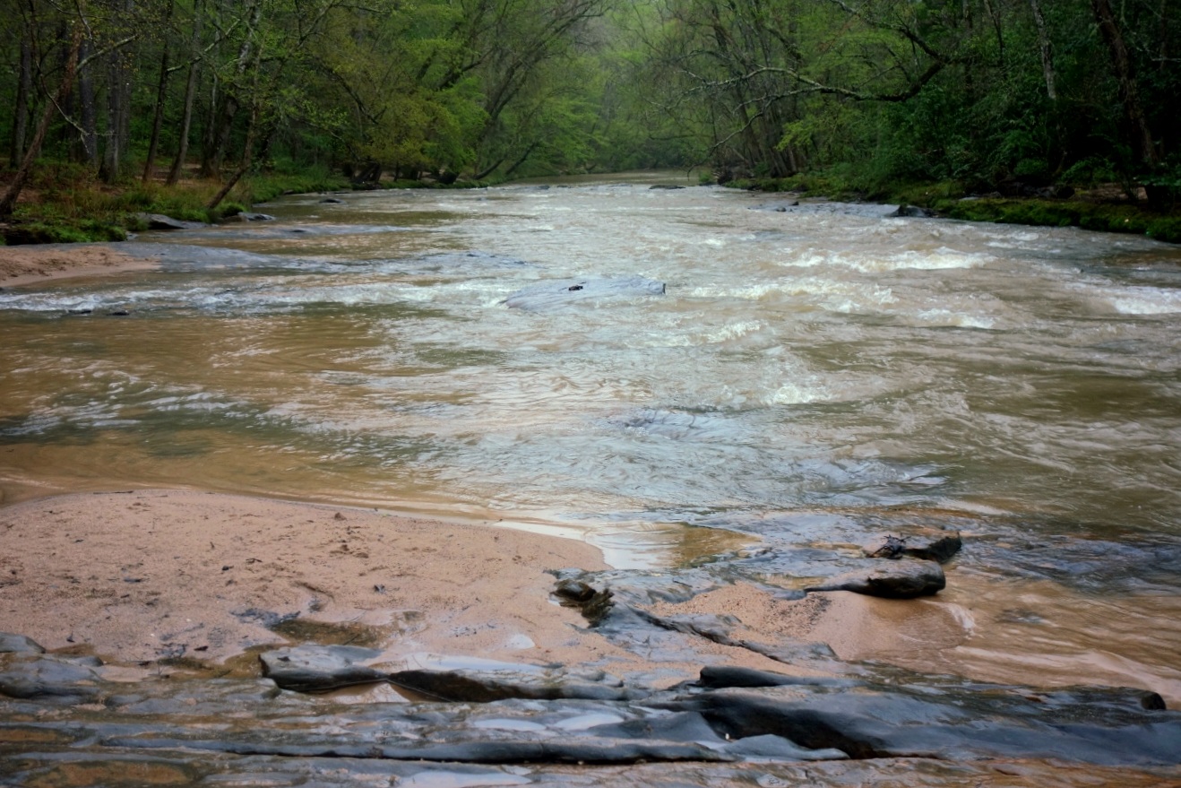
It didn’t take long before getting to the creek and seeing where the bridge used to be. It doesn’t seem that big of a deal so I scour up and down River to see if I can find a nice spot to cross. It’s starting to become clear that there is not a good way to get across unless you swim. I check my map and try to figure out how to get around. It looks like the best way around is going out the Park by road and around the otherside, but this would be a nine mile detour.

I reevaluate the sites I found and decide getting wet is probably the best choice. I stop and put all my electronics into my bear vault and then step into the first spot. The water is warm and the sand is very unstable. I shuffle towards the middle and slowly get lower in the water, I am up to my waist here when I feel a rock at my feet as well as the water running a bit faster. Now is when the panic starts to come in, the speed of the water and the sand and rocks I’m stepping on do not feel safe. I step back to the bank and see about another spot.
Everything in my head is telling me this just isn’t safe. The water seems to be running fast and at the same time the middle is alot deeper than what it looks. Between slippery boulders and the sand not being hard just adds to the fear of something bad happening. Regardless I make another attempt in a different spot. It looks much closer to the other side and all the current is on the bank close to me. But I found out immediately that it’s much deeper here and the first attempt and after getting in I immediately get right back out.
I stop and take a break at a nearby bench. Reevaluating the situation I decide this isn’t worth it, especially by myself. My initial plan was to connect to the next Passage and after completing that call my shuttle, and move down the trail. Now I am thinking I need to call my shuttle here in the Park and pass up the next section. Which is what I end up doing. After explaining on the phone that I have run into a problem trying to cross the creek, he comes and picks me up in the Park.

This website contains affiliate links, which means The Trek may receive a percentage of any product or service you purchase using the links in the articles or advertisements. The buyer pays the same price as they would otherwise, and your purchase helps to support The Trek's ongoing goal to serve you quality backpacking advice and information. Thanks for your support!
To learn more, please visit the About This Site page.

Comments 2
Good call on not pushing the envelope any further fording that stream. Glad to see you’re making progress and enjoying it along the way. Two months now before my PCT start date…still getting lots of snow in Northern WA so it’ll be interesting to see how things are in md-June. Go for it MAV! Max
Thanks Max, it was a condumdrum. I keep checking the snow at Harts Pass. I’m starting to worry for your June date. But you are more experienced in snow than me.