 ">
">
“We’re going to end this year with a very large Sierra snowpack and given the outlook…it’s very possible that we’ll end up vying for one of the top two snow years on record in parts of the state,” UCLA climate scientist Daniel Swain said in an online video update on Monday, February 27.
PCT Snowpack in the Sierra Outpaces Historic 2017 Season
Following a series of winter storms, snow levels along the PCT in the Sierra Nevada mountain range are officially higher than record 2017 snow levels for this date, according to Postholer.com. Snowpack in the Southern California mountains is also at a record high. Another atmospheric river is expected to dump additional feet of snow in the mountains at the end of this week, pushing accumulations even higher.
2017 previously saw the highest levels of Sierra “trail snow,” or snow within the PCT corridor, since Postholer began tracking PCT snow conditions in 2004. Trail snow data can be different from regional snow data reported by the California Department of Water Resources. Statewide snowpack, at 190 percent of average to date, is also rivaling the all-time record set in the winter of 1982–83.
Winter storm Piper, the first in a series of recent weather systems, brought record rainfall, flash floods, and light snow to low-elevation regions in Southern California starting on Thursday, February 23. Meanwhile, the Sierra mountains and mountainous regions of Southern California saw heavy snowfall from the storm through the weekend. Mountain High Ski Resort, located west of Wrightwood, was reported to have received the highest snowfall from Piper: 93 inches, or nearly eight feet.
The National Weather Service issued rare blizzard warnings for multiple regions across the southern part of the state, including the LA mountains and Ventura and San Bernardino Counties. Blizzard warnings were also issued for the Sierra, including Yosemite and Kings Canyon National Parks.
Avalanche warnings were issued for various regions across the state as well. On Sunday, February 26, a rare avalanche occurred on the north face of San Jacinto Peak.
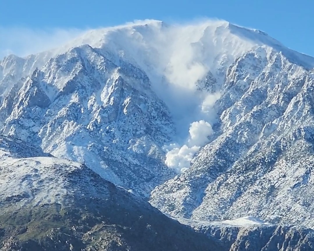
Avalanche on the north face of San Jacinto Peak. Videograb image captured by Joyce Schwartz; provided to San Jacinto Trail Report by Catherine Peterson.
After a brief break following Piper, another powerful weather system arrived last Tuesday, bringing more snow and rain to Southern California and heavy snow to the Sierra. The Sierra remained under a blizzard warning until 4 p.m. PST Wednesday, March 1. Yosemite National Park, which received significant snowfall, was reported to have snow depths of up to 15 feet in some areas. The park is closed for the foreseeable future until park crews can restore critical services.
What This Means For PCT Hikers
According to current data from the California Department of Water Resources, on March 7, statewide average snowpack was 192 percent of average. In comparison, the statewide average snowpack for the same date in 2017 was 182 percent of average.
In the Sierra, current average snowpack is also higher than it was at this time in 2017 for the Northern Sierra/Trinity, Central, and Southern regions. Postholer says that trail snow in the Sierra is 268 percent of average for this date.

2023 season Snow Water Equivalent (SWE) for the Sierra PCT in inches according to Snow Data Assimilation System (SNODAS) modeled snow data. Digital media via Postholer.com.
According to the National Weather Service Climate Prediction Center, a cold, stormy weather pattern continued through this week, which brought more heavy snow to the Sierra.
Parts of the PCT have also been closed in the interest of public safety:
- San Jacinto State Park: northbound mile 183.3 – 188.8
- San Bernardino National Forest: Northbound mile 149.5 – 206.5 and 234.5 – 361
Hikers should continue to monitor the PCTA’s trail closure page to get the latest updates.
Snow Safety
Founder of non-profit organization and wilderness school Mountain Education, Ned Tibbits, has urged PCT hikers with early March permit dates to postpone their start until the last in the series of winter storms has passed. The organization held several PCT ’23 Snow Hiking Safety Virtual Google Meetups, which can be watched here.
Hikers should be prepared to contend with high snow levels within the first 50 miles of trail as early as Mt. Laguna. Conditions will become more dangerous as hikers approach Mount Jacinto State Park. (As stated above, the park’s backcountry is closed for safety reasons due to the unprecedented snowfall.)
According to the San Jacinto Trail Report, seasonal snowfall for Idyllwild now totals 71.8 inches, which is 233 percent of average and the most since the winter of 1963–64.
In March 2020, PCT hiker Trevor “Microsoft” Laher died near Apache Peak in the San Jacinto Mountains (NOBO mile 169.5). If you’re not familiar with the details of this tragic accident, you can read about it here. Current conditions in the park are not to be taken lightly.
READ NEXT – Trevor Spikes Program To Ship Discounted Microspikes to PCT Hikers in Memory of Trevor Laher
Final Advice
In a recent Instagram post, The Trek offered the following advice to 2023 PCT thru-hikers wondering how to deal with this year’s snowpack:
1. Acquire the skills necessary before embarking to face the potentially record-breaking conditions on trail.
2. Switch to SOBO.
3. Be prepared for a very unconventional hike with flipping or waiting for additional thaw up north.
4. Wait for another year.
Backpacker Radio has also dedicated a pair of episodes to the challenges that will be faced by this year’s PCT hikers.
Continue to monitor the weather for the rest of winter as you make your final preparations for the hiking season. Postholer.com and the California Department of Water Resources are excellent resources for tracking the status of the PCT snowpack leading up to and during a thru-hike.
Featured image: Photo by Fred Greaves, California Department of Water Resources.

Affiliate Disclosure
This website contains affiliate links, which means The Trek may receive a percentage of any product or service you purchase using the links in the articles or advertisements. The buyer pays the same price as they would otherwise, and your purchase helps to support The Trek's ongoing goal to serve you quality backpacking advice and information. Thanks for your support!
To learn more, please visit the About This Site page.

Comments 10
I have been following the info on the snow this winter and I’m seeing exactly what you have reported. Thanks for alerting readers to the cautions and/or plan changes that are going to be necessary for this year’s hikers.
There is a new word for hikers in southern California to learn this year “Snow Down”. The chaparral and Oaks just aren’t use to heavy snow loads, and they just don’t hold up. Often, a nearby trail is the easiest place for them to fall.
There already is a record amount of snow in the sierras, and the weather forecast has 10 more feet over the next 3 days!
What does this record snowfall mean for the TRT, I’m planning to thru hike it staring July 21st.
It probably won’t be dry until the middle of August.
Even then there will still be large patches of snow on the north sides of mountains or in the shade.
If hikers are going to proceed w/their Nobo plans early season, acquiring some basic mountaineering skills/gear would be well worth the time and money. Real crampons and boots vs. micro-spikes and trail runners. Perhaps snowshoes – depending on departure date/temps. Learn how to use an ice axe (not just watch videos – but practice if you can). The real challenge will be creek crossings – where I would definitely carry a light 30m rope and cross with a group of people. Gear load, food carry is going to increase and mileage is likely to be lower – so will need to plan accordingly. My $0.02.
Agreed on the food carry. It’s not unusual to be down to ONE mile per hour in heavy snow.
So a HARD DAY’S hike could only get you 10 miles up the trail.
Definitely, never, never, ever, never cross a river ALONE. Always wait for someone to show up.
It’s not just the snow, it’s also how dangerous the river crossings are going to be in the Sierras.
In 2017 2 PCT hikers drowned trying to cross the rivers.
It looks like the PCTA is allowing flip flop permits. A nice flip flop would be get off at Kennedy Meadows South, then flip up to Chester and keep going north.
I doubt even Lake Tahoe up to Sierra City will be dry before the middle of August. Chester is usually a good place to get on.
Then after you get to Canada, flip back down to Chester and walk south back to KM south.
Ideally people would be walking the John Muir Trail section in late August to early September.
I would guess that section will still have SOME snow even on September 1st, but it will be passable.
(or…yeah…pick a different year, or come back to do the Sierra section by itself on a dry year)
Route finding will be a major and continuous challenge. Those smartphones with GPS Apps will run out of battery faster due to more use and colder temps.