 ">
">
PCT Week 4: About Trail Magic, Hot Springs and Lakes
The trail from Big Bear Lake to Wrightwood took in some highlights of the desert section. There were amazing lake views back to Big Bear Lake, I came by a lovely Hot Spring, there was Trail Magic as well as some more great lake views. Out of the middle of nowhere appeared the Interstate 15 with a McDonald’s and then something bad happened on the long way into Wrightwood.
PCT Day 18: Amazing Lake Views of Big Bear Lake
Big Bear (mile 266) to mile 282.6
20km (12.4mi) / 6h / elevation gain of 712m (2,335ft)
I was driving with physiotherapist and trail angel Jessica back to the trail from Big Bear. Somehow I was tired that morning, so I fell asleep in the car, and even when I started walking it was hard to keep my eyes open. But that got better the further I went. The trail went a bit uphill with a nice view into the valley and Lake Baldwin, an alkali lake that is dry half of the year. I went into the forest and took water for the next 18km (11mi). I had to scoop the water with my pot as there was not much flow. A scoop always comes in handy.

View of Lake Baldwin
I then climbed Bertha Peak (2,499m / 8201ft), which has a lovely view of Big Bear Lake and the snow-covered mountains behind it. The side trip took about 30 minutes roundtrip and a climb of 144m (472ft). The visit is only worthwhile to a limited extent as the PCT offered some equally beautiful lake views a little bit further ahead. I met a local man who was running up the mountain three times, just for training purposes. The PCT makes a little loop, taking the road would be a shortcut, but you would miss the best views of the day. The trail hugs the edge of the mountain and gives view of Big Bear Lake.

Big Bear Lake
After that, the trail continues into the forest and again in an open area with great mountain views. I found a good campsite at mile 282.6 with a bit of sunshine left. I could go further, but 5km (3mi) to the next spot were a little bit too much for me that day as I started quite late from Big Bear. There was a great sunset. The night was lonely once again, but this time I slept well. Maybe I get used to camping alone in the wilderness and all the sounds around me.
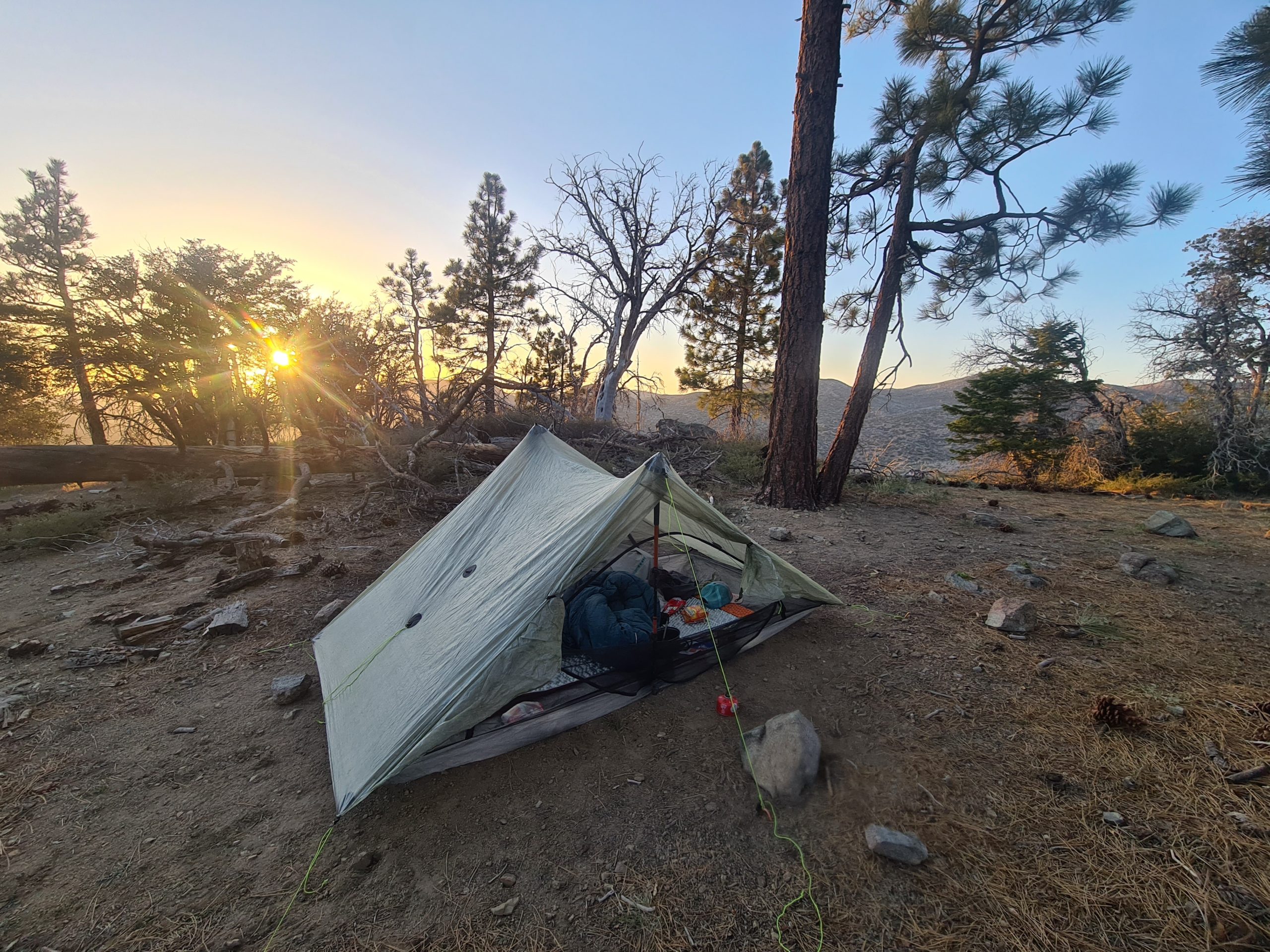
Lonely tentsite
PCT Day 19: Meandering through the Hills
mile 282.6 to mile 305.9
38.6km (24mi) / 8h / elevation gain of 400m (1,312ft)
The trail went mostly downhill and through hills that were sprinkled with scattered rocks. I got to a water source and refilled my water. Later I crossed the river again, balancing on a fallen tree. After 24km (15mi) I reached a bridge and under it was a great lunch spot by the riverside. You can even go swimming here. It’s a nice refreshment on a hot day.

What a great lunch spot at Deep Creek Bridge
After a long break, I took off again and followed Deep Creek, which was meandering in a little canyon below the trail. There was enough water today, so I didn’t need to carry much. I also passed the 300 miles marker.

300 miles done
I was thinking whether I should push on to the Hot Springs, but because it was Saturday night it might be crowded and loud as it’s a spot popular with locals on the weekends. So I pitched my tent 3km (1.8mi) before the Hot Springs to go there in the early morning. It was the next day that a fellow hiker told me that he found some mountain lion tracks right next to our tents and he didn’t want to tell me before as I would have had a bad night with that in my mind. He was probably right but still, I really wanted to see the tracks.
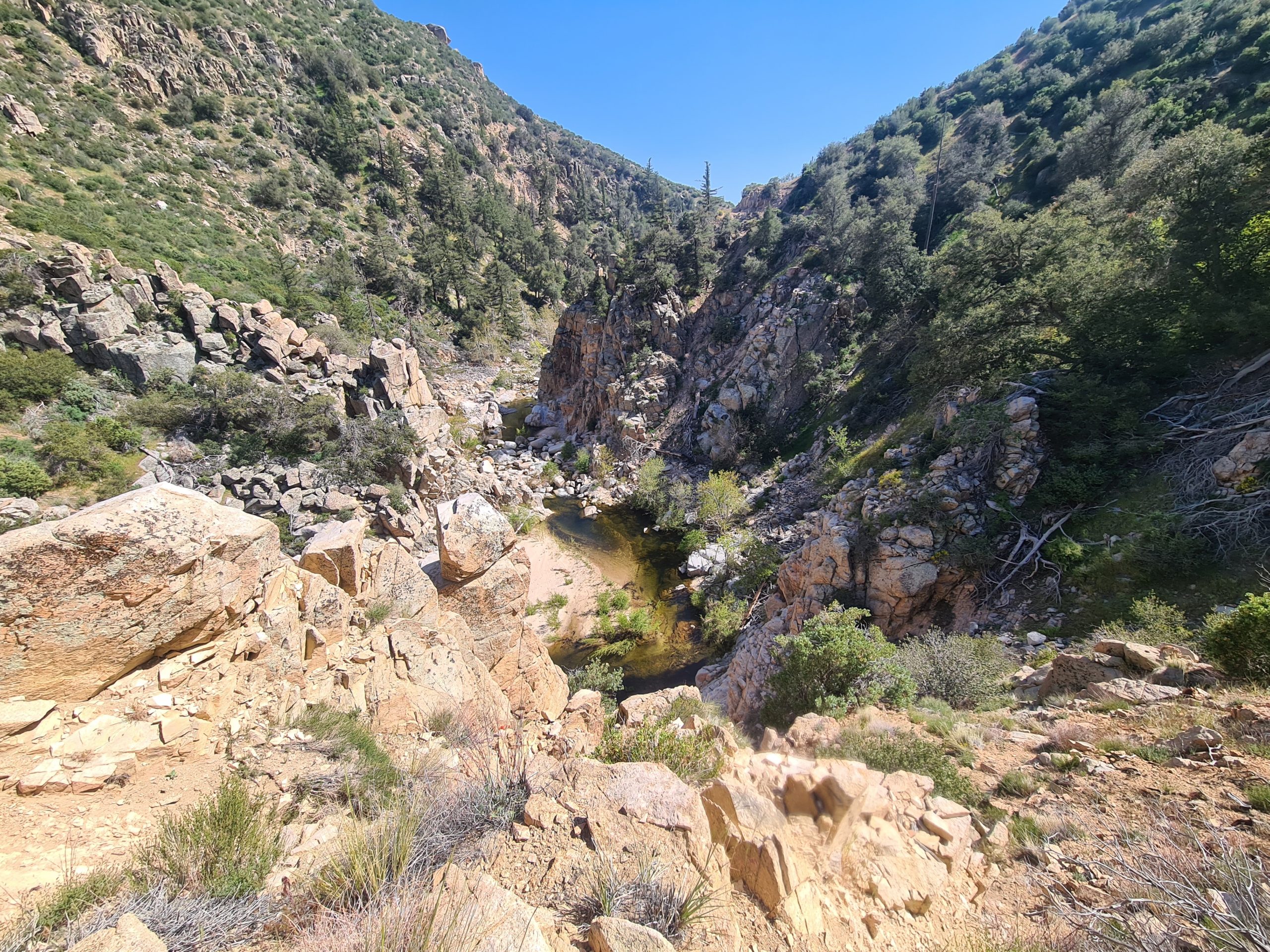
Deep Creek
PCT Day 20: Hot Springs, Trail Magic, and a Beautiful Lake
mile 305.9 to Silverwood Lake Campground (mile 328.9)
38km (23.6mi) / 8h / elevation gain of 724m (2,375ft)
It was just 3km (1.8mi) to the Hot Springs along the mountainside. As always it was very cold in the morning and so the Hot Springs were a real treat. There were a lot of locals who spent the night here, but I got a spot in one of the pools right beside the river. This one was convenient as I could change between the cold and hot water. If I would live around here I would come regularly to this beautiful place, but not on weekends. After a while, I rinsed off in the cold river, put my clothes back on, and walked further.
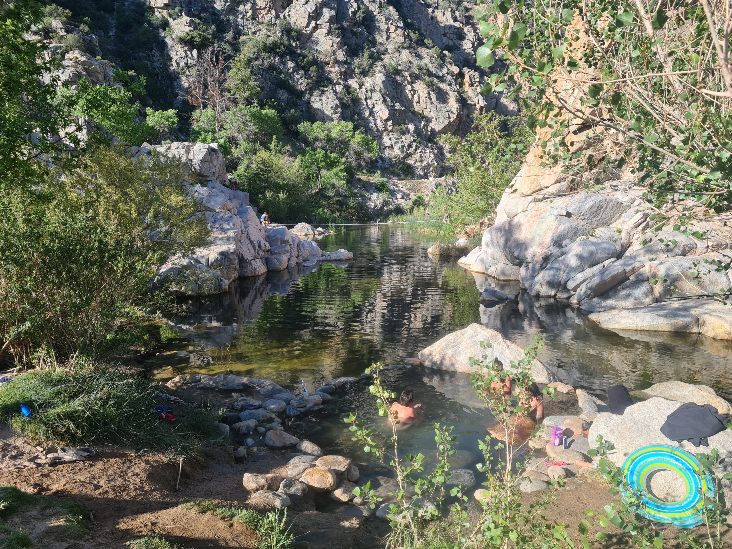
Deep Creek Hot Springs
At the end of the little canyon, there was a big dam, and the snow-covered 3,000m (10,000ft) high peak of Mount Baldy came into view. Switchbacks led down to the river and I did my first real river crossing on the PCT. So far it was possible to hop from stone to stone or to balance over a tree trunk. It was time to take off the shoes and go through the water to the other side. The ground was nice and sandy, with just a few small stones. As I reached the other side I found a lot of stinging nettles. So they have them here as well. Besides poison oak, poodle dog bush, and poison ivy there is a lot to look out for on the PCT.

Mojave River Forks Dam
The trail led uphill to a parking lot where there was unexpected trail magic. I got welcomed with an ice cream float by former PCT hikers Sugar Mama and Shepherd and later they made us some burgers. Trail magic always comes at the right time.

Trail Magic
So I didn’t make as many miles as usual to lunchtime, but the day was still long enough. The trail went further up and along the mountainside. Below me, there was the valley floor with a lot of bushes and Mount Baldy towered in the background.

Mount Baldy in the background
It was hot again and after 18km (11mi) I reached a water source. It got water for the next 17km (10.5mi) which took a while. My Platypus bottle broke and my filter system is not very efficient without it as the smartwater bottles are not squeezable. Also, my food drybag ripped this morning. I don’t know what’s happening with my gear this year. I got to another large dam and reached the road. It was the first time the PCT went right beside the road, but never on the road, just on a trail beside it. Even if there are lonely dirt roads, the PCT always has its own trail. I like it a lot that there is no road walking.
From the road, the trail went uphill again and suddenly I could see pretty Silverwood Lake in the middle of the brushy and rocky hillsides. The trail went high up along its shore for the next miles and offered great views of the lake and its sandy bays. Unfortunately, there is no camping allowed at the lake, just at an official campground off-trail, so I had to hurry a bit to reach it in time. That was a pity as the beaches were so inviting to stay and have a swim. After every corner there was more of the lake, it just seemed endless. But there was a lot of poison oak, too. So better keep your eyes on the trail.

Silverwood Lake
Finally, I reached a road and I followed it up one extra mile to the campsite. I took a shower and then I ordered some food with another hiker which was a great end to a perfect day with Hot Springs, trail magic, and amazing views of the lake.

Silverwood Lake
PCT Day 21: McDonald’s!
Silverwood Lake Campground (mile 328.9) to Swarthout Canyon (mile 347.2)
31.3km (19.4mi) / 7h / elevation gain of 811m
From the campground, I walked the one mile back to the trail which then went uphill. At the highest point, I had a nice view of Cajon Pass and the mountains and hills before that. It was just 5km (3mi) more down in switchbacks to a small canyon. After a total of 22km (13.6mi), I reached the junction to McDonald’s at lunchtime.

View down to Cajon Pass
It’s right next to the busy Interstate 15, so it was a real shock with all the noise from the cars after being away from civilization. A lot of hikers gathered in the shade right next to the gas station and munched on their McDonald’s. The inside of the store is closed at the moment so we had to order and eat outside. I also bought some snacks and soda in the gas station, which was not good for resupply, but enough to buy some snacks. I was resting for 2.5h in the shade. And, I had some fruits for dessert from a little fruit stall. I couldn’t finish it all so I took them with me for the evening. Fresh food is always nice.

Junction to McDonald’s
I finally took off to walk the 8.6km (5.3mi) to the water cache where I wanted to camp. I left the busy road and went through two tunnels under the interstate and railway tracks. Soon after climbing into the dusty hills, I had a great view of Cajon Pass and the railroad tracks with really long trains passing through. The trail went along the mountainside with a beautiful view of green hills, rocks, valleys, and mountains. It went uphill just in the beginning, then it got nice and easy. I got side stitches because I had way too much food, but I didn’t want to stop so I just raised my arms in the air and that helped.

On the way up from Cajon Pass
At the campsite, there was a big water cache and it’s the last water for the next 27km (16.7mi) that are going uphill. It would be over 35km (21.7mi) to the road to Wrightwood tomorrow with a lot of elevation gain, so I was not sure if I was able to make it tomorrow. Even if it was 6km (3.7mi) away I could still hear the trains whistling all night.

Beautiful ridge walk on the way to the water cache
PCT Day 22: A long day into Wrightwood and Shit Happens
Swarthout Canyon (mile 347.2) to Highway 2 (mile 369.3) and hitching into Wrightwood
35.2km (21.8mi) / 8h / elevation gain of 1,700m (5,577ft)

Sunrise
Today was mostly uphill. The trail winded its way up the mountainside, but never was too steep and it was easy to walk, much easier than thought. From the beginning of the day, I had a slight pain in my left heel, but I ignored it. Turned out that this was a mistake. As higher as I got the snow-covered peaks of Mount Baldy and others around came into view. I walked through sparse mountain forest and took a lunch break at the highest point. I arranged a night with trail angel Maria in Wrightwood as I had some cell phone reception up here. She would also pick me up from the highway.

Mountain views
After this break the pain moved from the heel to my lower calf and I still didn’t think much of it until it got way worse with every step. Again, the trail went up to almost 2,600m (8,530ft) and then mostly down, passing a skiing area. There were also some small patches of snow to cross. Meanwhile, the pain got very strong, especially while going downhill. I needed to stop again to take some Ibuprofen. I was lucky that it wasn’t that far to the road anymore and that I was on my way into town and could do a rest day to recover. But I learned something new again: Take care of any kind of pain immediately. Stop, rest, try to figure out what’s going on. Don’t just ignore it. You need to listen to your body.
Mountain views on the way to Wrightwood
I got to the road and Maria picked me up. She took me in like family, I even got my own room. Another hiker was here with me and after shower and laundry, Maria even made us dinner. I was so grateful to have such a lovely place to recover. In the evening I did some research about the pain and it turned out soon that it must be the Achilles tendon. The spot was red and swollen now and I could feel a small knot. This was very discouraging for me as these things can take a lot of time and I was not sure if I could continue my hike like that. Cooling helped a lot though.

On the way to Wrightwood
Zero Day in Wrightwood
I did a zero in Wrightwood to recover my Achilles tendon. I tried to buy KT tape in Wrightwood, but neither the Hardware store nor the grocery store had it available.
Wrightwood is a cute little town and very hiker-friendly. The hardware store has a list of trail angels offering rides and accommodation. You can also get a PCT pin with signing the trail register and a small gas canister for just 1 cent if you spent 30$ at the store. Also, the gas station gives hikers a hot dog for free.

Food for the next 5 to 6 days to Acton
I did my resupply in the grocery store and then decided to hitchhike to Phelan, the next city, where there is a pharmacy. Also, I contacted a physiotherapist who is driving up and down the PCT with her van to help us hikers. She wasn’t in the area at the moment but offered me a telehealth call later in the afternoon so I would know what to do next and if I could continue my hike. I didn’t have any pain walking around in town that day though, which gave me hope.
I easily got a ride to Phelan, where I got the tape, Ibuprofen, and Diclofenac gel. At that point, I thought that there would be a bus back to Wrightwood but it turned out that there isn’t. I spent some time in the library and then tried to get a Lyft or Uber but it wasn’t possible. As the town is a bit spread out it would be hard to get a hitch back into my direction. I would need to walk back to the highway but there would be no way to stop for cars and it was quite far away.
So I had my call with Morgan, the physiotherapist from Blaze Physiotherapy, in the parking lot. She confirmed my self-diagnosis, it was definitely an Achilles tendonitis. But she said I could go on, because I didn’t have any pain today, and she gave me a lot of tips. To take it slow, making fewer miles, taking a break as soon as the pain arises, doing some exercises, taking Ibuprofen, and taping my Achilles. So, I will try tomorrow and take it slow for now.
Finally, I got a Lyft ride out of town after I tried for a long time. Back at Maria’s place a new hiker arrived. Brian is a marathon runner preparing for the Olympic trials in 2028 and every day after doing his miles hiking he’s doing a 5-mile run as well. On zero days he does a long run. Crazy. I’m done after a day hiking and wouldn’t even think about going for a run. To everybody who thinks I’m crazy to do a 2,650 mile hike from Mexico to Canada, there are always people being even crazier.
I found a sitting pad in Maria’s hikerbox and it seemed to be the perfect hack for finally making my hip belt tighter so it takes more weight off my shoulders. The trail provides. Still trying to eat as much as I can to fix that problem.

Taping my Achilles tendon (and padded my hip belt of my backpack to make it tighter)

This website contains affiliate links, which means The Trek may receive a percentage of any product or service you purchase using the links in the articles or advertisements. The buyer pays the same price as they would otherwise, and your purchase helps to support The Trek's ongoing goal to serve you quality backpacking advice and information. Thanks for your support!
To learn more, please visit the About This Site page.

Comments 3
Beautiful photos, AA! Glad your Achilles is better.
Bravo, Annika!
Love reading all your posts, from NZ to EU and now PCT.
Thanks for bringing us all along for the adventure.
Hi Annika,
nice posts, looking forward for more. I keep my fingers crossed that your achilles tendon doesn’t give you lots of trouble. My tendon ruptured after some pain and a jump and that was no fun. My wife is currently also on the PCT, probably a week behind you. Her trail name is “turtle” and she’s a German Canadian. For me it’s very interesting to read your posts after talking to my wife to understand what she has to expect ahead for her. All the best Andreas