 ">
">
Sierra Conditions Early June 2023
All about the current conditions in the Sierra along the PCT during our last week.
Hey guys, and hello from Bishop! Before reading on, please let me first remind you about something important to me:
Like in my last post, I would like to repeat that I am not encouraging anyone to go out there into the Sierra. Nasty Cheese and I are no pros, but we researched, trained, and learned a lot about this and did everything to make it possible to go through the last section. If you want to go out there, you will do it on your responsibility. Please be trained, advised, and skilled. Every fun moment can turn into a life-threatening event any second.
I am posting this article to inform people about the actual conditions out there.
If you are unsure but want to try it anyways, the section from KMS to Lone Pine is perfect to check the conditions; it will become much, much harder behind the Cottonwood Campground. Know that conditions may change quickly, so my post might not be useful anymore next week.

Forester Pass was relatively easy, when you are trained enough
OK! But how was it?
Frightening, beautiful, bone-breaking, astonishing, brutal, mind-breaking, pure happiness, and sheer terror in the same moment. There are no words for what we have gone through since Lone Pine. Words can’t describe this rollercoaster of heavy emotions.
We cannot believe it right now, but we did about 130 miles through the Sierra Nevada in this record-breaking snow year and made it safe to Bishop! We are incredibly proud of ourselves and our crew. Never before have I done something this extreme, challenging, but also beautiful. Thursday morning, while climbing Pinchot Pass, I turned around to see the sunrise and almost cried out of pure bliss.

I prefered the mornings in high altitude. Less slush, less water, less heat
In this post, I want to describe everything about current conditions, the water crossings, the passes, and the snow itself. I will post a second post where I’ll describe our journey of the past 7 days, so make sure to follow on Insta or subscribe!
Follow our journey on Instagram!But let me first describe our strategy from Lone Pine: we hiked up the Horseshoe Meadows Road on Saturday, the 27th of May. From there on, the strategy was to do alpine starts at around 3-4 AM every morning to have frozen snow and a good chance to cross the upcoming passes.
We also wanted to pass the rivers until noon and set up camp at around 2 PM to avoid the melt avalanches. We also didn’t want to do more than 14 miles per day.
We stuck to this plan until the end, except for two days where we ended up hiking longer as the snow was too slushy.
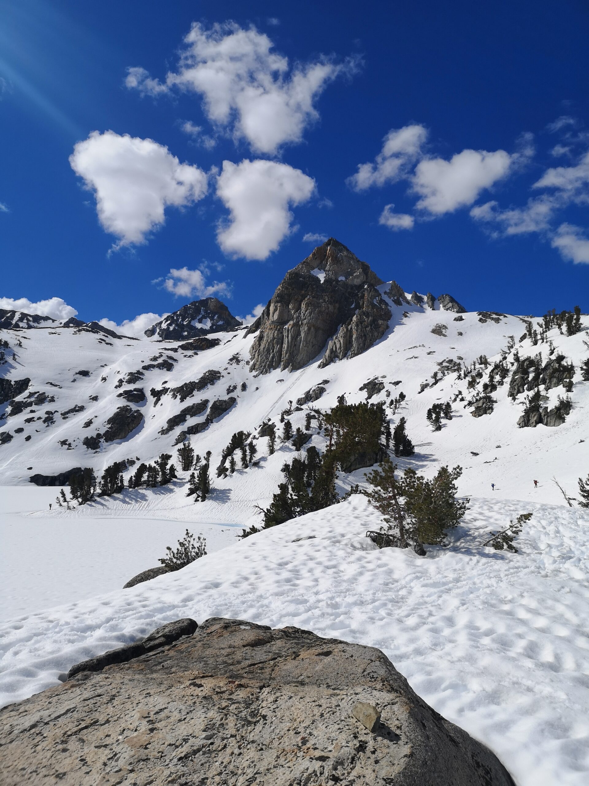
Suncups everywhere
How is the snow?
Depends on the time of the day… We found out that it starts to freeze at about 3 AM. From then on, the snow is in a very nice walkable condition. Means: rock hard. We could sometimes make 2.5 Mph in the early mornings. This holds on until around 3 hours after sunrise. From then on, slush-hell starts. Means 1 mph MAX. While the snow was in a walkable consistency until noon in the beginning, it turned into a slush at around nine during the last two days of our hike. The whole Sierra is still covered; there won’t be many dry spots after 9000 feet, and we almost always camped above that. Every time after noon, you should be extremely aware of melt avalanches.
Snowbridges still exist in a huge variety. (I love them) but they will melt quickly away in the next weeks.

Love me a nice snow bridge. Tyndall Crk is already roaring
Water Crossings
I hate them. They freak me out. The passes are fun. Crossings are my nightmare. Luckily we just had 3 wet crossings at Rock, Wallace, and Whitney Creek. Whitney was nice and slow, the other two were really strong pulling, and the melt is happening. I would not recommend crossing any waters after RayDay… We could do all the other crossings via snow bridges.
Make sure to download the list of the Skurka Alternates to have better crossing spots at hand!

You are lucky if you find footsteps.
The Passes
For me, the most fun part! You get up early (too cold to sleep in anyways), you start hiking on hard snow, a starry sky above you, and approach these giant stone walls that want to be taken.
When we went through, every pass had very good steps! We always used crampons and ice axes on the passes. The steps were made by other hikers. Except for Forester Pass, the steps did not follow the trail, so be prepared for steeeep climbs in deep steps. The level of difficulty for the passes to me was from easiest to hardest: Pinchot, Forester, Glen, and then, of course, Mather!
Pinchot was just a stairway, Forester was big, but half the way up a snow-free trail! Glen was kinda high and a long traverse could be difficult for people who are afraid of heights. They all took about 30 min to climb.
Mather looks very scary, but if you follow the steps of “Shopper” (see his comment at the pass in FarOut) and not the trail, you will have a rather easy climb, as the original trail has no good steps.
Never do the passes after 9 AM, as the snow could be too soft, and you risk an avalanche and destroying the steps of those awesome people who did them before us. Thank you to all of you! I owe you all a beer!

The valleys are covered with destroyed trees. I don’t know if the JMT is gonna be doable this year.
Gear
Sleeping: Take an inflatable and a foam pad with you. Put the foam pad on top for extra warmth. We put a summer quilt on top of the sleeping bag (20°f extr) and slept toasty warm.
Walking: Crampons plus microspikes are recommended. Spikes are simply faster to walk in, and crampons for the passes. We heard from a group with snow shoes that they ditched theirs in Independence.
SOS: Take a satellite device with you. No discussion. Take it with you. You can rent them.
Sun protection: Sunglasses and SPF 50 sunscreen and we had zero problems.
Navigation: The App that everybody uses because of the comments is NOT meant for navigation in the mountains. Download an offline map with the trail, and use Locus Maps or Gaja. They are accurate and the maps are detailed enough. Take a paper map; it is the backcountry!

Navigation is key!
Recommended Skills
Be prepared to be alone. We walked 6 days without seeing another soul except for our 3-headed (later 4) group. You’ll feel like the only remaining person on the planet.
Navigation: Know how to read maps! By that I don’t mean following an arrow along a line! Know how to understand high lines. There will be no tracks, no trail; you will have to navigate on your own.
Safety: Question every action you do. Every wrong decision can be severe out there. It takes hours before a helicopter arrives. If it arrives.
For example: is the water safe to cross? Is this section too steep to climb up? Am I in avalanche danger? Is there something underneath the snow? Or even better:
Climb Whitney like everyone else without knowing anything about it? NO. Leave it! The mountain will still be there next year. Never lose respect for the mountains. You are just a guest out there.
I hope I could help y’all with this post. If there are any questions, leave a comment, text me on Instagram, or visit me in Bishop! 😀

This website contains affiliate links, which means The Trek may receive a percentage of any product or service you purchase using the links in the articles or advertisements. The buyer pays the same price as they would otherwise, and your purchase helps to support The Trek's ongoing goal to serve you quality backpacking advice and information. Thanks for your support!
To learn more, please visit the About This Site page.

Comments 11
Beautiful scenery !!! Must have been great hiking under the stars.
I love the early mornings. First look goes for the Dipper and the Milky Way, but they set early and from 5 on you don’t need a headlamp that much. It is very could though, we might have brought some frostbite with us
Beautiful pics and sobering narrative. Hike On!
Than you! Will do! =)
I’m not on trail, but I do trail magic and support at the Carson Wilderness zone, and I absorb and appreciate all of your narrative. I drove up to the Bishop Pass trailhead on June 4 as you were writing this post, and of course saw I conditions as never before in my lifetime. You and the others have my greatest respect for transiting this zone at this time.
Thank you so much, Laurence! After coming down to town and seeing the pictures, I can’t believe it myself. It seems so normal being up there, but also hard, and easy and I don’t know how to describe it! It is just extreme.
WHERE WAS THE 3RD PIC TAKEN? [ITS THE ONE WITH THE POINTY PEAK IN THE CENTER AND THE HIKER FOLLOWING THE PERIMETER OF THE LAKE]
It’s the mountain “Painted Lady” taken from Rae Lakes
Wow! That is absolutely correct!
I THOUGHT SO. WOW, THERE IS A LOT OF SNOW! I’M HEADED THERE IN 3 WEEKS.
WOW! I’m just reading these stories… I’m not a hiker. I loved reading your story, especially the way you made it clear to be trained and prepared for this type of hiking. Good on you!! I’m definitely going to be reading your stories to see what happens… you’ve hooked me!