 ">
">
SoCal Snow – And Why We’re Flipping Around the Sierra
Mt. Laguna
March 30, 2023
Our second morning on trail we woke up to a truck pulling into the otherwise empty campground. I immediately unzipped my rainfly. Was it rangers? We had paid for the site. I wanted to get eyes on this person before they were right next to us. The rain was freezing and sloughing off our tent in a little ice pile, and the wind and hail kept us up most of the night.
“Good morning!” said the man with the gray beard, “are you guys okay?”
He introduced himself as the trail angel Ghost. He had decided to drive through the campground to see if there were any thru-hikers who needed help after rain and freezing temps. “Wow, our first trail angel!” I thought. But this was the third person since we arrived at Lake Morena the day before who expressed concern about us continuing on in the storm.
“Come with me, I’ll give you a ride to Cleef,” he said.
“Crap,” I thought, that’s back at the southern terminus. Not that we had come far at this point, but how would we get back here? Wouldn’t we be out in the rain either way? We could always sleep in the pit toilet if things got bad.
I asked my hiking partner Macy what she thought. This was our first trip together and this was the first test of our collective decision making. She replied, “Let’s wait it out a bit.” Ghost gave us his number and told us to let him know if we changed our minds, he could swing by later. “Don’t go forward,” he said, “you’re just below the snowline.”
“Okay,” we agreed, knowing we hadn’t made up our minds.
The truck drove off, and we were left to discuss our options. Looking at the forecast, we decided there could be a weather window for moving forward if we left right away. Even if we could move forward a little bit today, we would be within shooting range of Mt. Laguna the next day, the first trail town where we knew we could resupply and dry out our gear. This wouldn’t be the worst conditions we would run into, we thought. We were prepared, we had each other, we were heading to another site with an emergency pit toilet shelter. We wanted to ignore the people who told the two women starting a massive trail not to go forward, so we moved on.
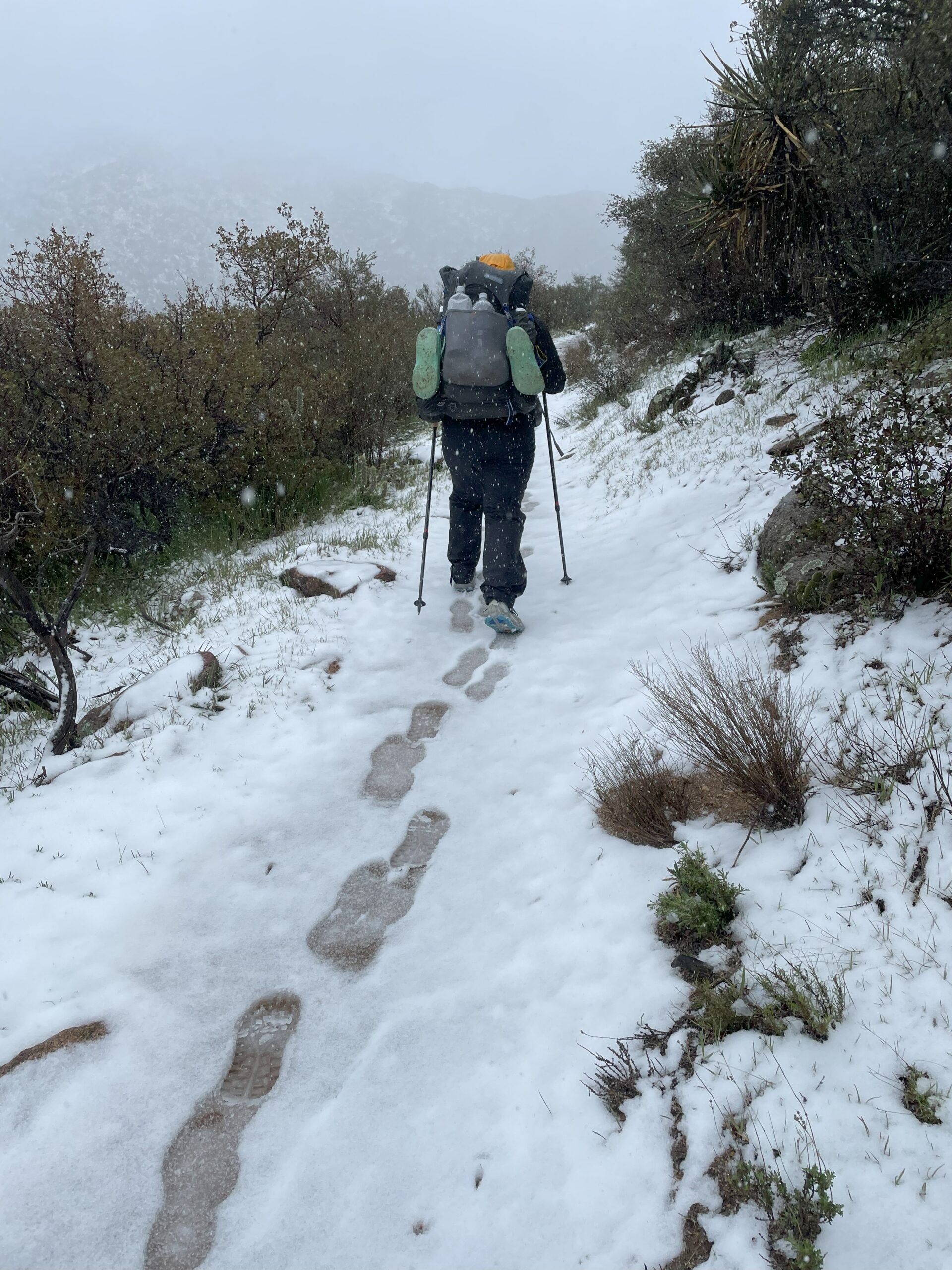
Hiking towards Mt. Laguna; Day 3 on the PCT
In the end, whether we continued or stayed back at Lake Morena, we would have made the same miles. We moved slowly through the snow and slush, which quickly melted over the next few days, and those who had stayed behind caught up to us. But those moments of debate and discussion – either as a team or individually – build trust. Trust in yourself and trust in your group. That trust and that thought process have carried us through so many other times on the trail so far.
Building strength, we began to push further into the next sections without snow. We also started to meet other thru-hikers (those first days in the snow had been quiet). Each day brought new views, wind, heat, water carries, and flowers. It is impossible to know what the trail will bring next.
San Jacinto
April 12 – 15, 2023
As we hiked through the first 150 miles of trail, the snowy ridgeline leading to San Jacinto slowly came closer into view. An unprecedented closure of Mount San Jacinto State Park lifted the week before we arrived. Whether or not to continue on PCT through this section would be our next decision. Should we take the lower elevation Black Mountain road alternate around the range? Or continue over Apache Peak and the snow slabs towards San Jacinto?
Reaching Paradise Valley Cafe – we turned off trail into Idyllwild to rest for a few days and assess the snow conditions going forward. We had been hiking around the same people for the past week, and splitting a hotel for three nights solidified us into a group that would move forward together into the next section. Sitting in Idyllwild, we constantly checked any information we could get about what conditions we should expect and be prepared for on the ridgeline ahead. Jon’s San Jacinto Trail Reports (sanjacjon.com) were invaluable, as well as any tidbit of advice we could glean from FarOut comments, Facebook, Instagram, and folks we ran into in town. But the bottom line was that not too many teams had passed through this section yet and the information we had was always going to be imperfect. To move forward we had to accept that there was always going to be some risk, but also trust ourselves to make good decisions.
Finally, with a team of seven, and lots of contingency plans and bail options – we felt comfortable getting back on trail and continuing on towards Spitler and Apache peaks.
We got to our first camp, the saddle just below Spitler late enough that there were not many good tent sites left. Deciding to cowboy camp (sleeping on the ground without setting up our shelters), we laid out our Tyvek ground sheets and huddled together in the wind. The clouds descended and we spent the night in a cold mist with an ambitious 4:00 a.m. wake-up time.
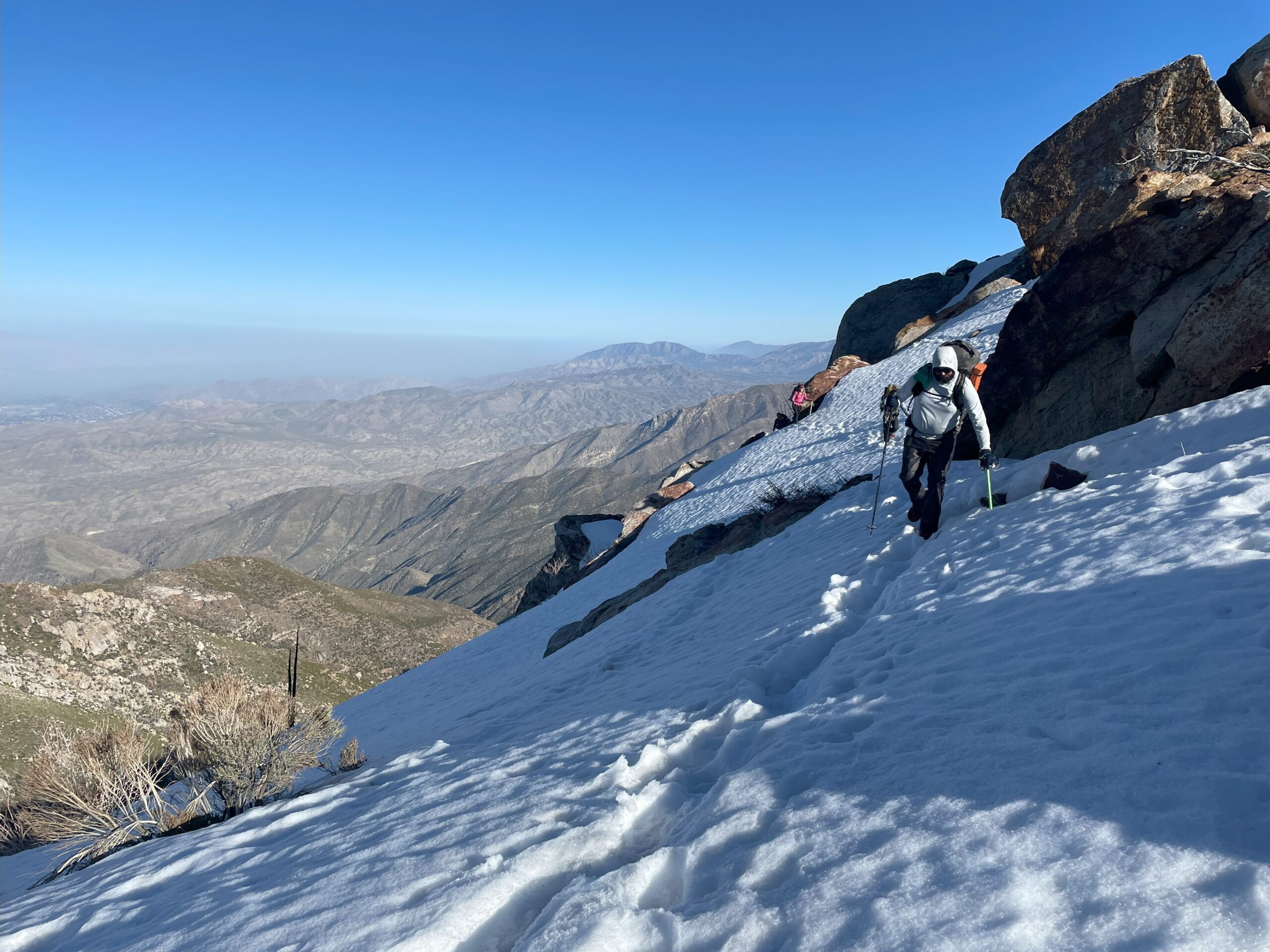
As we walked out into the early morning light, we all had some anxieties about what the day would bring. The wind and mist whipped up and over the ridge. Though the cool weather and lack of sun probably kept the snow we were walking on stable, the discomfort, and lack of visibility, added to our collective anxiety. After navigating lots of blowdowns, we opted for going up and over Apache Peak, rather than following the trail which wrapped around the mountain on the steep snow fields below.

Frosty cloudy morning
Crossing the rest of the ridgeline, we were mostly able to follow the steps of those that had passed through before us. The traverse would have been much more difficult if these tracks were not there. Not only providing easier navigation, they also gave us the mental assurance that we were following a route that someone had passed through before.
Each snowfield we reached presented its own decision and risk assessment. Do I still feel comfortable moving through this? I drew on my past experience in snow and in rock climbing to continue moving forward.
Facing short sections of manageable risk seemed okay and snowfield after snowfield we made our way across. Each time asking, “How many more? Were we close?” The clouds that had been blocking our view forward suddenly cleared and revealed where we were along the ridge. As the sun soaked us, the anxious mood eased, the intensity level softened, and we could finally see what we had been plodding towards for the past 10+ hours. Just a little ways left and we would be close to Red Tahquitz at camp.
Snowy ridgeline leading up to camp
 Knowing that we had at least 2 more days of trekking through full snow, some of our team dropped back down into Idyllwild, while the rest of us continued up and over San Jacinto Peak and back down towards Fuller Ridge.

Summit of San Jacinto
Moving north across Fuller Ridge proved to be much more low-key than the terrain we had seen before.
Finally, dropping down, down, down, back into the desert, we were out of the snow and back on the comforting dirt path that promised to take us where we were trying to go (North).
Big Bear to Baden-Powell
April 23 – 30, 2023
Passing over San Jacinto solidified our core tramily (trail-family). We began planning ahead of time where we would camp each night. While I often hiked alone during the day, it was awesome to meet up with the same crew each night. As we pushed further into spring, the SoCal weather improved and we switched from spending nights alone in our tents, to cowboy camping almost exclusively.

Cowboy camp under San Jacinto
Past Big Bear we dropped back down to lower elevations and were treated by again following this year’s stunning flower bloom.
But soon, another snowy range was fast approaching. This time Baden-Powell and the ridgeline to follow would be the last snow we would hit before the Sierra. While other groups were gearing back up, I felt okay about this mountain for a few reasons. First, three years prior, my partner and I had attempted a winter hike of Baden-Powell. We hadn’t made it all the way to the summit but this was primarily due to running out of daylight – not conditions. “Now it is spring conditions – we’ll be fine,” I rationalized. I had also been on the ridgeline after the summit before, albeit not in the snow. I didn’t realize until later that I hadn’t quite done the homework I should have to move forward.
Climbing up out of the trail town of Wrightwood, the snow quickly slowed us down. But, reaching the ridgeline headed toward Baden-Powell was gorgeous. The Southern California mountains always surprise me.
Day 2 out of town we began making our way up towards the summit of Baden-Powell. Hitting some ice lower down, I put my microspikes on. “Crap,” I thought, “I should have brought my ice axe.” Assessing the conditions and consequences of a fall, I decided it was okay to keep moving forward. However, the fact that the conditions were pretty different from what I expected threw me off, and reminded me that snow conditions year to year, day to day, and even throughout the day can change dramatically.
Ridgeline leading to the summit of Mt. Baden-Powell. After a stunning view from the summit, we summited most of the peaks on the following ridgeline. Staying up high was often easier than traversing on the slopes below. Yet this also meant that by the end of the day, we had a lot more elevation gain and loss than if we had stayed strictly on the trail. Worn out by the end of the day, we arrived at a mostly snow-covered campsite.

Macy finding a snow-free spot to camp (Photo credit: Markus Folz)
The next morning, up earlier than the rest of the group and not expecting too much of a challenge, I headed out on my own. Checking in with my hiking partner Macy, “I’ll meet you at the parking lot,” I said. This was two miles ahead where the trail crosses the highway. Loving the quiet early morning hiking, I continued on.
Almost to the road, I reached an icy slope. Spikes on, but no ice axe, I contemplated the fall. “It’s two steps to the other side,” I thought. Quickly hopping over, I was through, but turning the corner, a much longer icy stretch presented itself. “It’s not freezing at night, I wasn’t expecting this.” Looking at the long icy run out – I decided I couldn’t do it with the gear I had. Annoyed with myself for being under-prepared, I tried to think of other options. “How else could I get through here?”
Much more comfortable on rock rather than ice, I found a way to scramble up and around, so that I could at least see what was around the next corner. “Great it is clear.” I waited for Macy and another friend to catch up and showed them the route around the ice.
However, making our way back to the trail, we soon hit a final ice patch, hundreds of feet long. Collectively we wanted to keep going. Having completed all of the other snowy sections, the trail pulled us forward. But, the risk with the gear we currently had with us was too high. Finally pulling the plug, we bailed down to the mountain highway the trail follows through this section.
Out of the snow, I was disappointed that we hadn’t brought the gear to continue through, but also relieved that we had found a safe way out. Each experience like this is something to draw on in the future – a situation I’ve found myself into and out of – something that has taught me I have more to learn.
The road walk around the next snowy section and the following trail closure to avoid endangered mountain yellow-legged frog habitat turned out to be beautiful as well. The road was still closed for snow, so we had the place and views to ourselves.

Road alternate near Wrightwood
Onward
Heading north from the San Gabriel range brought entirely new scenery. With reasonable temperatures on our side, we hiked the infamous aqueduct in the afternoon and evening and sang hours of karaoke along the way. The next days brought us through fields of windmills and then into the trail town of Tehachapi.

Flowers and windmills headed into Tehachapi
Why we are flipping around the Sierras
May 10, 2023
Now, sitting in Tehachapi, the southern Sierras and the record snowfall there are finally staring us down. It seemed like the thru-hikers around us had collectively been avoiding the topic of what comes after reaching Kennedy Meadows, where the trail quickly climbs to 10,000+ feet. Conversations about the Sierra quickly turn into a debate in which typically no one was actually swayed from their original decision. But, the Sierra discussion can no longer be avoided.
Those pushing through are facing the reality that many of the resupply roads are closed, the collapse of the San Joaquin River bridge will add many miles to route around, and the rivers will soon be rising to hazardous levels with snow melt. Given this, and numerous in-person and online discussions happening right now, I wanted to quickly outline the reasons Macy and I are flipping around the Sierras this year and what this looks like for the rest of our hike.
First, why flip? Many of these reasons have been discussed in other places, but for us:
- Our top concern is hazardous water crossings. As hikers that clock in at 5’ 1” and 5’ 7” the snow melt and river crossings are not trivial. Water that is safe for some people to cross could be waist-deep for us.
- There is still a very significant snow pack – folks in our tramily are going in with full mountaineering gear – boots, crampons, snowshoes, a 4-season tent, and 10 + days of food. Ultimately, I don’t currently trust my skillset to commit to this section. I hope one day to build these skills. But, for now, I only know there is a lot I don’t know.
- A HUGE part of our hike is our study of trash and microplastics. See our article here for an introduction to this project. However, our methods require us to collect soil for our microplastic analysis. Collecting snow instead would require different equipment and processing. Overall, we believe our study will be more informative if we pass through this section later in the summer.
What do we think our flip-flop will look like?
There are still a lot of challenges for hikers flipping past the Sierra. Most of the trail north of the Sierras is still covered in snow and we will definitely hit snow moving forward. But, our goal is to break up the snowy sections. This way we are hiking in the snow for days not weeks, and hit the areas that will melt out first earlier in the early season.
After tagging Kennedy Meadows (south) we are taking a week off and then heading up to Chester, CA to rejoin the trail. We will certainly be in the snow just north of there in Lassen Volcanic National Park, but we will quickly drop elevation into one of the NorCal sections that are early to melt out . We have changed our permits to continue to the Canadian border from there and then flip back to Chester to hike the Sierra southbound and complete our full hike back at Kennedy Meadows.
Arriving at Kennedy Meadows last week!
We expect our hike will be a lot quieter for a while. Hikers this year are going in all different directions. Some are taking many weeks off, others are pushing straight through, and others still are piecing together different sections. We are psyched for the teams heading into the Sierra and will miss the crew we have been hiking with. But, this is definitely the year to embrace hike your own hike.
P.S. Another update is in the works. Our next post will be a full recap on the desert section of our trail trash survey – stay tuned!

This website contains affiliate links, which means The Trek may receive a percentage of any product or service you purchase using the links in the articles or advertisements. The buyer pays the same price as they would otherwise, and your purchase helps to support The Trek's ongoing goal to serve you quality backpacking advice and information. Thanks for your support!
To learn more, please visit the About This Site page.
