 ">
">
The Best-Laid Plans, Part One
Dunsmuir is a nice place, but it doesn’t have many accommodation options. My hotel wasn’t as expensive as the one in Chester, but my credit card still took a hit. If you want to save money, staying in the town of Mount Shasta is probably the wiser choice.
I resupplied at the Dollar General and IGA Supermarket, and the next morning, took a Mount Shasta Taxi back to the trail. Before leaving, I checked the status of the wildfires between Etna and Ashland.
- McKinney Fire, 80% contained.
- Yeti Fire, 90% contained.
When I first learned of these fires, in Chester, there was almost no chance the PCT would reopen in time. When I left Burney, there was a small possibility. Leaving Dunsmuir, I guessed the odds were actually now in my favor. Containment of the McKinney Fire had doubled in the last five days. I was willing to bet that both fires would be fully contained by the time I arrived in Etna, five days out. In which case, I’d be able to continue to Ashland, and finally complete the California section of the PCT.
I was in an optimistic mood as I started uphill towards the Castle Crags Wilderness. The traffic noise from Interstate 5 faded slowly, and the day warmed up quickly. As usual, when leaving town, I’d planned for a half-mileage day. A mile from camp, as I began to clear the tree-line and feel the full heat of the sun, I was glad to be stopping early.
That sinking feeling
I completed the climb before eight the following morning, and the rest of the day was a relatively flat ridge-walk. Minimal effort and maximal views. I camped at the eastern end of Porcupine Lake, about a quarter mile from the PCT. There, I found a small, blue, sit-on-top kayak marked with a “Max 130 lbs” warning. I discovered the hard way that it was designed to sink when the weight limit was exceeded. Fortunately it was a warm day, and I dried out before bedtime.
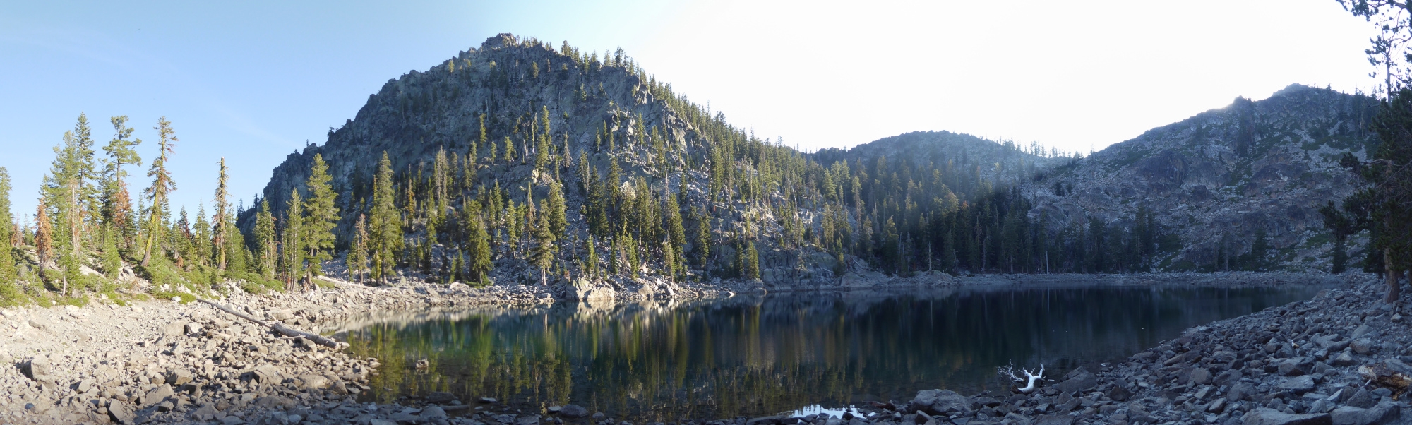
Porcupine Lake.
For two more days, I trundled on alone, enjoying the rolling terrain and spending much of my time above the tree-line. The Trinity Alps Wilderness was just as pretty as I expected, even if I wasn’t expecting it to be grazed by cattle. I encountered one herd blocking the trail, but another herd, I only heard. Apparently, in order to provide hikers with an authentic Alpine experience, all cows had been issued with cowbells.
Depending on the status of the wildfires, I knew the next day might be my last full day on trail. I set off at the same time as usual, and after an hour, caught up with another NOBO (trail name: Late Start). We hiked together until Paynes Lake, which is where I intended to camp. Sawyers Bar Road was only another five miles, and Late Start continued hiking. She wanted to get to Etna that evening, but I wanted to enjoy one more night in the backcountry.
Then it started raining.
A bar
It rained again the next morning while I was taking down my tent, which I guessed was a bad omen. A thick layer of cloud covered the sky, and the landscape looked a little less colorful than usual. The conditions matched my mood. Heavy rain started to fall just before I arrived at Sawyers Bar Road.
At the trailhead, there was a large board displaying wildfire and trail-closure information. The most important word was visible from a distance: CLOSED. I waited in the rain for about 15 minutes, and during that time, only one vehicle drove past. It was heading away from Etna, and I figured this was going to be a tough hitch, so I started walking.
Just over an hour later, a car approached that was going in the right direction. The driver, Alex, dropped me off in town, where I immediately checked the PCTA and InciWeb sites. Etna to Ashland, the only California section I had yet to complete, was indeed still closed.
But then, some good news. I discovered that on Thursdays, it’s only two dollars for a beer at Etna Brewing Company. I met Late Start there for lunch, and again for dinner. She mentioned that she’d spoken to a local trail angel, Molly, who was driving to Medford the next day. I contacted Molly, who very kindly agreed to take me with her.

Hiking to Sawyers Bar Road.
Another bar
Molly dropped me off at a bar in Medford. The same place where I’d spent the afternoon of Labor Day 2021 after California’s National Forests had closed. I had the same plan this time around.
- Spend the afternoon at the bar.
- Catch a late movie.
- Walk to the bus station in time for the 2:40 AM Greyhound.
While sitting outside the bar, I checked the PCTA’s list of fire closures. The Lionshead Fire closure had just been lifted, so the Oregon section I had to skip in 2021 was now open. That gave me an idea.
Another plan
About six hours later, I left the bar and tottered in the direction of the movie theater. I’d describe my condition that evening as not-entirely-sober. While waiting in line to buy a movie ticket, I was approached by a security guard who told me that my backpack was too large, and I wouldn’t be allowed in. A big thank-you to the man in line behind me, Joe, who offered to store my backpack in his truck during the movie.
I sobered up while watching the film, retrieved my backpack, hung around outside the movie theater, and walked to the bus station. I arrived home 18 hours later with a fully-formed plan for finishing the PCT.
- Spend two days doing chores, buying supplies, etc.
- Drive back to Oregon and park at the Frog Lake Trailhead.
- Hike south for about 45 miles, turn around and hike back.
- Drive to the Santiam Pass Trailhead.
- Hike north for about 45 miles, turn around and hike back.
- Drive to Etna.
- Hike from Etna to Ashland.
My guess was that the PCT between Etna and Ashland would reopen when the existing closure order expired. I’d be back in Etna when that happened. In the meantime, two out-and-back hikes would keep my motor running, and I’d complete the section affected by the Lionshead Fire. I was hopeful that 2022 might be my year to finish the PCT after all.

This website contains affiliate links, which means The Trek may receive a percentage of any product or service you purchase using the links in the articles or advertisements. The buyer pays the same price as they would otherwise, and your purchase helps to support The Trek's ongoing goal to serve you quality backpacking advice and information. Thanks for your support!
To learn more, please visit the About This Site page.

Comments 4
My trail brother -Pink Panther, former Olympic canoeing coach- repaired a hole in that kayak with his pocket rocket. She’s sea worthy for smaller folks!
Hi Chevy!
My fault entirely. I exceeded the weight limit by about 30 pounds, but couldn’t resist having a go. I think the last time I saw you was at Disappearing Creek, about 10 miles after Dunsmuir. Give my regards to Pink Panther, Chipper, Petunia and Rockhopper. Hopefully everyone enjoyed the rest of the hike.
– Low Range
Aa