 ">
">
The Trek Through NorCal
End of the Desert
The last time I posted anything to this blog, I left off on our first day out of Palm Springs. Well, that was now months and many, many miles ago. To catch you all up on our hike through the rest of the desert is a more daunting task than I’m willing to face at the moment so for now I will just say this: the desert was a hell of a trip. It was cold and rainy and we got squeezed into a bottleneck of what often felt like way too many hikers on account of the weather. We took a two-day detour to LA and ate sushi and saw Owen Wilson on Venice Beach. We returned and got rained on some more. We carried water for 20 miles three days in a row and it never felt like we had enough water. We saw lots of Joshua trees and sagebrush. We experienced amazing trail magic in the form of huge water caches maintained by thoughtful trail angels. We enjoyed the painted canyons and all the little critters, and by the time we reached Kennedy Meadows on June 8, we were ready for a new section.

Some decor that we got a real good look at while we drank on the porch.
What a cutie.

Happy to be bidding farewell the sagebrush.
We spent a little over 24 hours in Kennedy Meadows, although it felt like weeks. By 10 a.m. on June 9 it seemed all there was to do was sit on the porch drinking wine, and by the time Dan’s mom, Susie, arrived to pick us up, we had just finished our fourth bottle. We had been consuming a high-quality combination of Beringer and Barefoot pinot grigio all day and I’m pretty sure I was hungover for two days as a result.
Vacation from Our Vacation
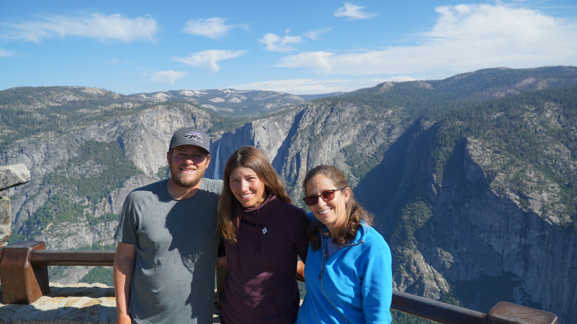
After we made our final decision to flip north and leave the Sierra until later in the summer when they hopefully aren’t so snowy, Susie very generously agreed to fly out to California and drive us up to the town of Chester to resume our walk to Canada. We took a little vacation from hiking for a couple of days and saw some sights. We all experienced Sequoia and Yosemite for the first time together, visited the REI in Fresno, played mini golf to celebrate my 30th birthday (I really love mini golf, what can I say?), and showered three times in four days, which was absolutely crazy. Susie dropped us off at the trailhead in Chester late in the afternoon on June 13 and we started heading north on foot once more.

Dan and Susie checking out the view at Glacier Point in Yosemite.
All three of us 🙂

Thirsty.

Yosemite Falls.

Half Dome.

Vernal Fall.
Back at It
Our first few days in Northern California were a roller coaster. The first ten miles took us through a beautiful, shady pine forest that was so welcoming it seemed too good to be true. It turned out quickly that it was. That night we camped next to a creek that was home to a bloodthirsty horde of mosquitoes. There was a fire pit, so we built a small fire to keep them away and it helped, but they pressed themselves menacingly against the sides of our tent by the dozens as the sun went down and we fell asleep fearing what might be waiting for us in the wet section ahead.
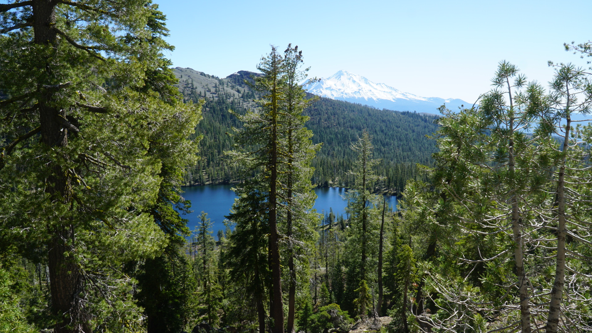
The next morning we entered Lassen National Park. The first few miles were beautiful and took us through lush green meadows and past a boiling sulfur lake. At the campground where we stopped for lunch, we met a girl named Tippy Toes who was an ice climber from the French Alps. She told us she had gone into the Sierra and gotten frostbite on both her feet and had just gotten back on trail after two weeks recovering in Bishop. She said that she felt fine that day until she got her feet wet, but that walking was very painful afterward and she might just stay at the campground. The campground was nice and shady, had no mosquitoes during the day, and had bear boxes for our food (we were supposed to have bear canisters for the 20-mile section through the park but didn’t). Although we had only gone ten miles so far and had planned to do 17 more to reach the park boundary that night, we decided to stay too. It turned out to be the right call.

Boiling lake.

After the desert this meadow looked soooooo green.
Losing the Trail and a Trekking Pole
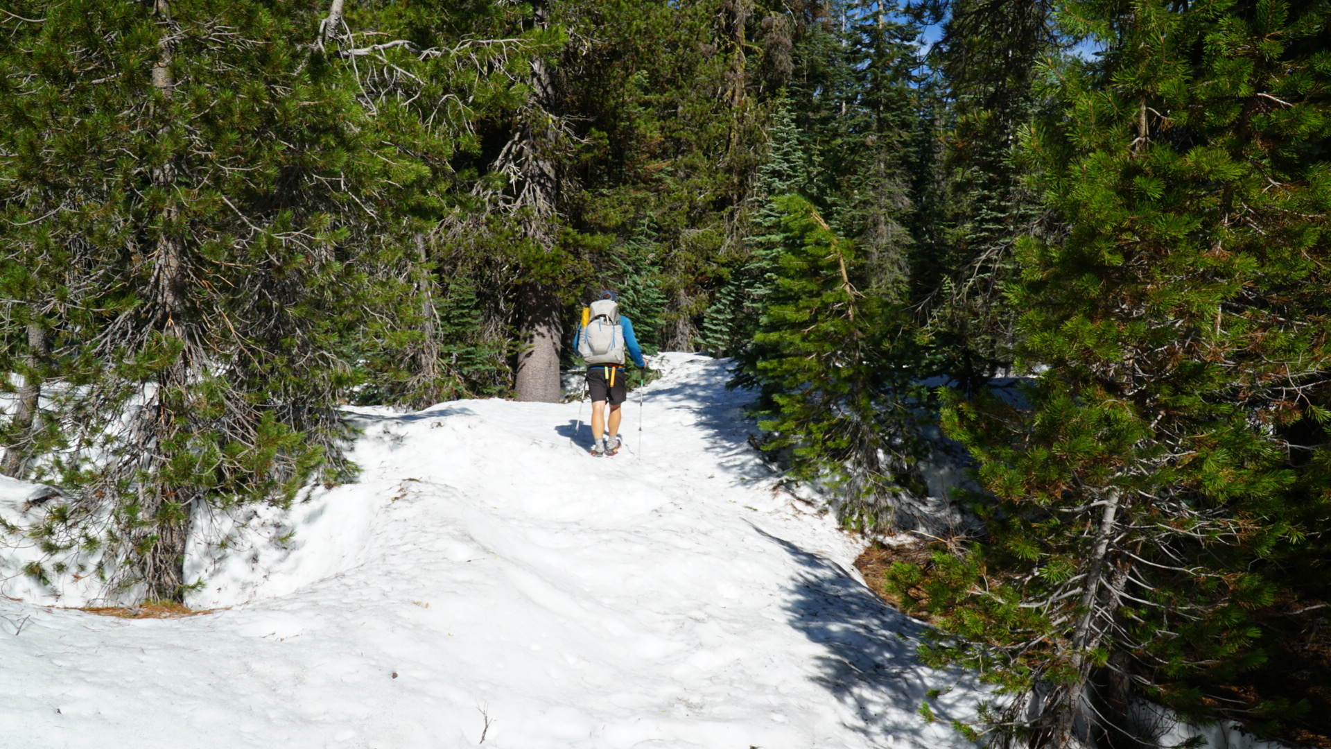
The next morning we climbed out of the campground and into a tough section of solid snow. Although plenty of people had gone through before us, their footprints had apparently melted and the trail was very difficult to find. Dan walked in front of me with his GPS out making sure we didn’t stray too far from the PCT while I slipped and stumbled and postholed behind him. The saturated forest floor made the patches without snow a haven for mosquitoes and the normally peaceful creeks running across the trail were swollen to mid-thigh-deep raging rivers that invariably took a minimum of 30 minutes to cross as we searched up and down for the safest place to enter the water. Early in the day I fell into one of them and lost a trekking pole as I scrambled to regain my balance. Since Dan is the more coordinated of the two of us, he insisted on giving me one of his trekking poles and he has borne the unhappy burden of being a uni-pole ever since. Around noon we realized that we had only gone four miles in four hours and that we probably weren’t going to make it out of Lassen by nightfall, or find a good place to camp. We looked at the map and saw that a mile behind us there was a trail leading to Summit Lake and a road which, even if it wasn’t plowed, would be easier to follow out of the park than the PCT. We made the frustrating decision to turn around and repeat a river crossing we had just done. We got to the junction and since the trail to the lake was of course covered in five to ten feet of snow as well, proceeded to bushwhack the three miles to the road. When we finally got there we saw footprints and other such evidence that we were not the first thru-hikers to make this move. Most tellingly, there was a distinctive smiley face drawn in the snow with a trekking pole that we had been seeing in the desert for hundreds of miles. Mercifully we found that the road was plowed and we started walking down it toward highway 44 hoping to hitch into Old Station. After five or six or seven miles we reached a section of the road that was open to traffic and got picked up by a family in a Subaru who drove us the rest of the way to 44, then by a nice young man who took us to Old Station, where we ate dinner and camped behind a gas station.

When we could find the trail, it too was a river.
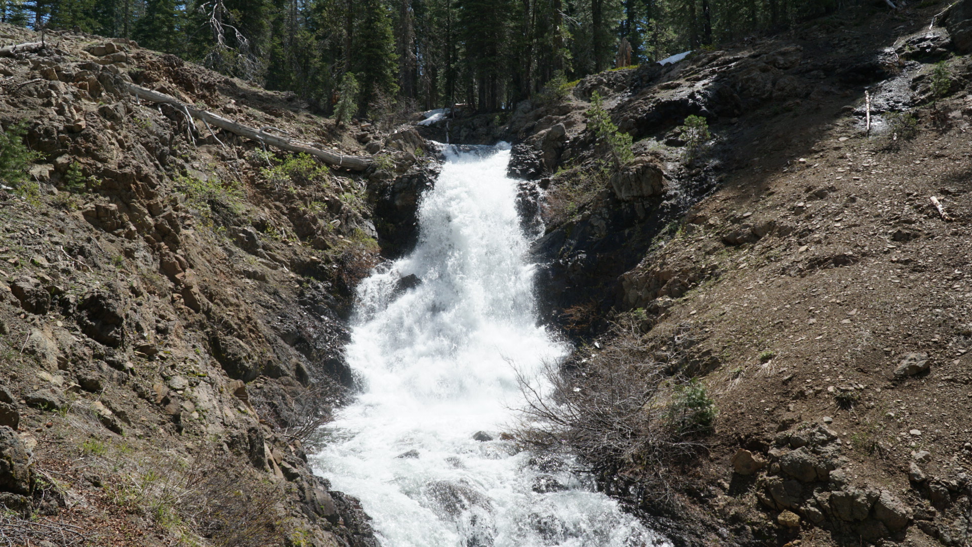
Apparently this waterfall is usually so low key that no one even bothered to name it.

Looks safe.

Mount Lassen.
The trail?
Heat, Rocks, Poison Oak, Mosquitoes
The next few days were very hot and we spent them walking through mosquito hell. Between Lassen and Burney the trail winds along a mellow but very exposed ridge that is home to a cow pasture and is a haven for things that bite. The morning we walked into Burney we woke up around 5 hoping to get to town by early afternoon but this meant that the little vampires were out in full force. The trail that day also happened to traverse very hard ground with uneven volcanic flooring and was totally overgrown with poison oak. We booked it downhill, tripping on the ground and trying desperately to dodge the evil plants while swatting away the thousands of mosquitoes swarming our heads. About eight miles in I saw a car pass about 25 feet to my right and asked Dan if the road paralleled the trail. He said it did and it went pretty much all the way to Burney. I told him we should take it. Doing so solved nearly all our problems (uneven ground, poison oak, mosquitoes). But it was hot in the sun. Still, we stayed on the road and took it the rest of the way to town.

Hey look, it’s Shasta!

I wish I could say it was good knowin’ ya, Lassen.
Fortunately at Burney Falls my soul sister and once upon a time hiking partner, Chelsea (aka Foxy Shazam), had buried us a geocache that contained four cold beers and a lovely note to lift our spirits. We drank them by a river and went swimming to cool off. The day after was even hotter and buggier but we had some amazing views of Mount Shasta. One night we slept next to some power lines where a family of deer crept around our tent till dawn. The day that followed was the first day of summer. We woke up ready to hike 30 miles but only ended up hiking ten after abandoning the trail to go swimming in a lake. We hitched to the town of Mount Shasta that night and scored the very last campsite at the KOA.

If your friends don’t leave you buried treasure in the form of cold beers, you need new friends.

Burney Falls.

Snack with a view of Shasta.
Miracles in Mount Shasta
The next morning Dan awoke to a text from his friend Nathan, whom he worked with last summer, saying that he just happened to be driving through Mount Shasta. This was incredible news because it meant that not only did we get to spend time with a friend, it meant we had access to a car. Nathan drove us to two different grocery stores and we got to just keep our stuff in his truck! We didn’t have to haul it around in our arms from place to place! But seeing Nathan was not the only serendipitous event that occurred that day in Mount Shasta. My old phone had mysteriously decided to stop charging beyond 3% battery the day Susie dropped us back off at the trail, so when I called my dad to wish him a happy Father’s Day from Dan’s phone, he said his birthday present to me would be a phone (thanks Dad!). I told him he could mail it to the Mount Shasta Visitors Center, since they accepted hiker packages and were open seven days a week. When we arrived, however, there was no package. We checked the tracking number and discovered that a delivery had been attempted but no one had been there to receive it. We were devastated. It was Saturday, so this meant that our options were to either stay in town till Monday or hike out and somehow try to get back to town from farther up the trail. Both choices were terrible. I decided to walk to the post office, even though I knew it would be closed, and hope for a miracle. No more than five minutes after I got there, one came. I saw a mail truck drive around back and ran after it. I approached the driver, a guy in his 50s with long silver hair, and said, “Excuse me, sir. I know it’s Saturday but I was supposed to pick up a package at the visitors center today. I looked up the tracking number and it said it couldn’t be delivered. Is there anything I can do about it today?” The man smiled and said no but put a finger to his lips and nodded yes. He knew exactly which package I was talking about and Dan and Nathan pulled up in the truck just as he came back out of the building with my phone! I thanked him and told him he was a great man and had just given me the best trail magic of my life. Then I hopped in the truck and Nathan drove us back to the trail.

Dan and Nathan.
Dreamland
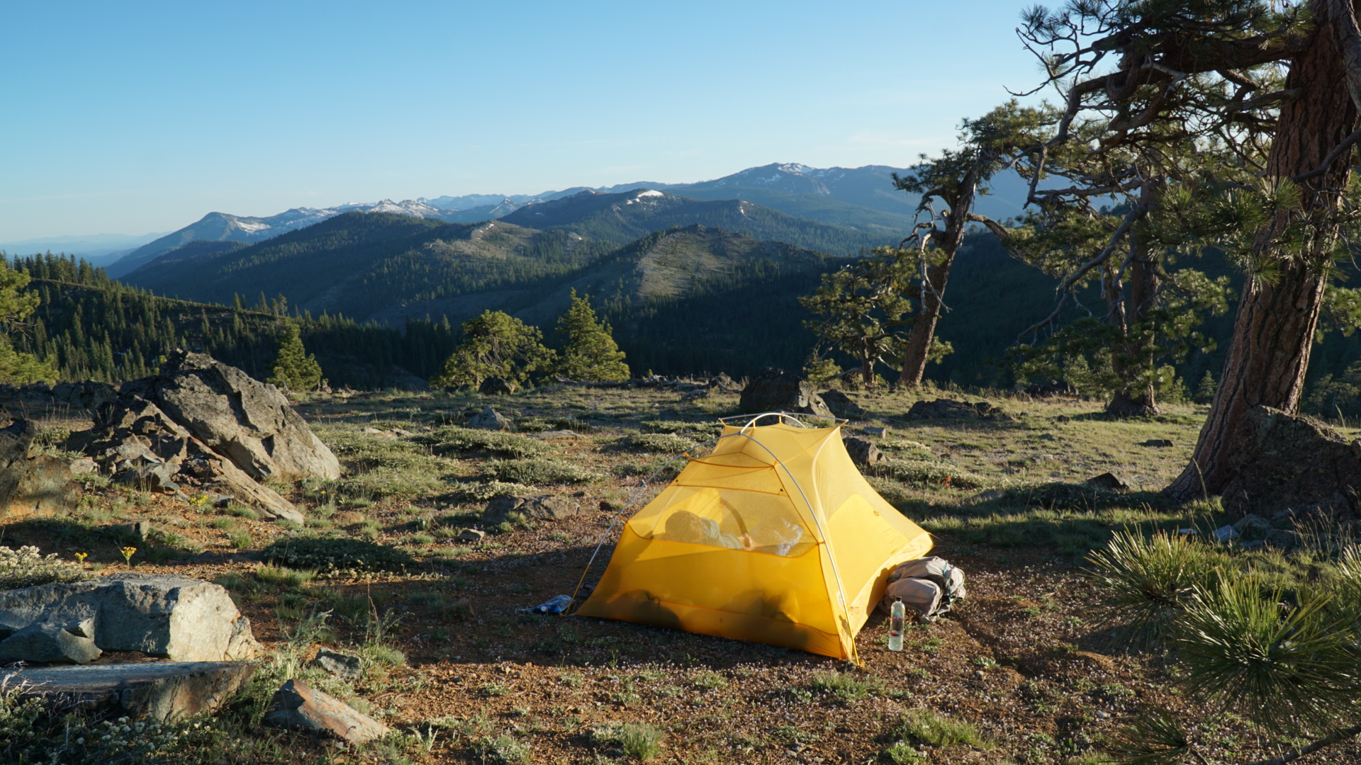
After that we were officially in the Trinity Alps, which so far have been the most beautiful part of the PCT (and that’s really saying something). Through that section the days were cool and easy. The bad mosquitoes were mostly gone and we spent the whole time walking a gentle trail through gorgeous moss-covered pines, past clear deep blue lakes, and across dramatic snowcapped peaks. It was dreamy and surreal and magnificent. The only bother was the fact that cows were apparently allowed to graze there and there was a ton of erosion and cow poop. That part was sad, but otherwise it was an absolute dream. We capped off that section with a night camping in the park in the lovely little town of Etna. A nice woman who had been hiking with her husband but was now off trail with an injury approached our tent while we were eating dinner and offered to drive us back to the trail the next morning.

Yeah, we slept here.

When you camp directly west of Shasta.
Wow.

Deadfall Lake.

“Wow.”
Wow.

Woooooow.

Just wow.

I can’t wait to come back.
Back to Reality
She drove us to Etna summit, where we encountered very cold weather and an impending storm. We made it ten miles before it started to rain. We had plenty of food so we just set up our tent and spent the afternoon relaxing and watching movies. The rest of the stretch from Etna to Seiad Valley was largely burned and as a result the undergrowth was out of control. There were many downed trees and places where you had fight your way through thick bushes and vines. But we got to see Marble Mountain and we hit our 1,000-mile mark, so that was cool. We finally got to Seiad Valley on a Saturday. It was our last stop in California. We camped at the Wildwood Tavern and ate some of the very best food we’ve had the whole trail there. Then we hiked out with just about 40 miles left to the Oregon border.

Walking through the Marble Mountain Wilderness.

A beautiful morning.

?

Only 1650 to go!
A New State
We are currently in Ashland, OR, where we spent our anniversary at Callahan’s Lodge—an unbelievably hiker friendly hotel that allows you to camp on their back lawn. We are excited for a new state and to see what adventures Oregon brings.

Welcome to Oregon.

This website contains affiliate links, which means The Trek may receive a percentage of any product or service you purchase using the links in the articles or advertisements. The buyer pays the same price as they would otherwise, and your purchase helps to support The Trek's ongoing goal to serve you quality backpacking advice and information. Thanks for your support!
To learn more, please visit the About This Site page.
