 ">
">
PCT Week 8: Going into the Sierra
Finally, we are getting into the promised land of the Sierra Nevada, climbing progressively higher starting from Kennedy Meadows. We are climbing the highest peak of the USA outside of Alaska in between, going over the highest pass of the PCT just one day later. Endless ridgelines, an abundance of mountain views, lakes, creeks, and marmots are on our way through this spectacular section.
PCT Day 41: Into the Sierra
Kennedy Meadows Camp (mile 704.6) bis mile 725
33.4km (20.7mi) / 8h / elevation gain of 1,600m (5,249ft)
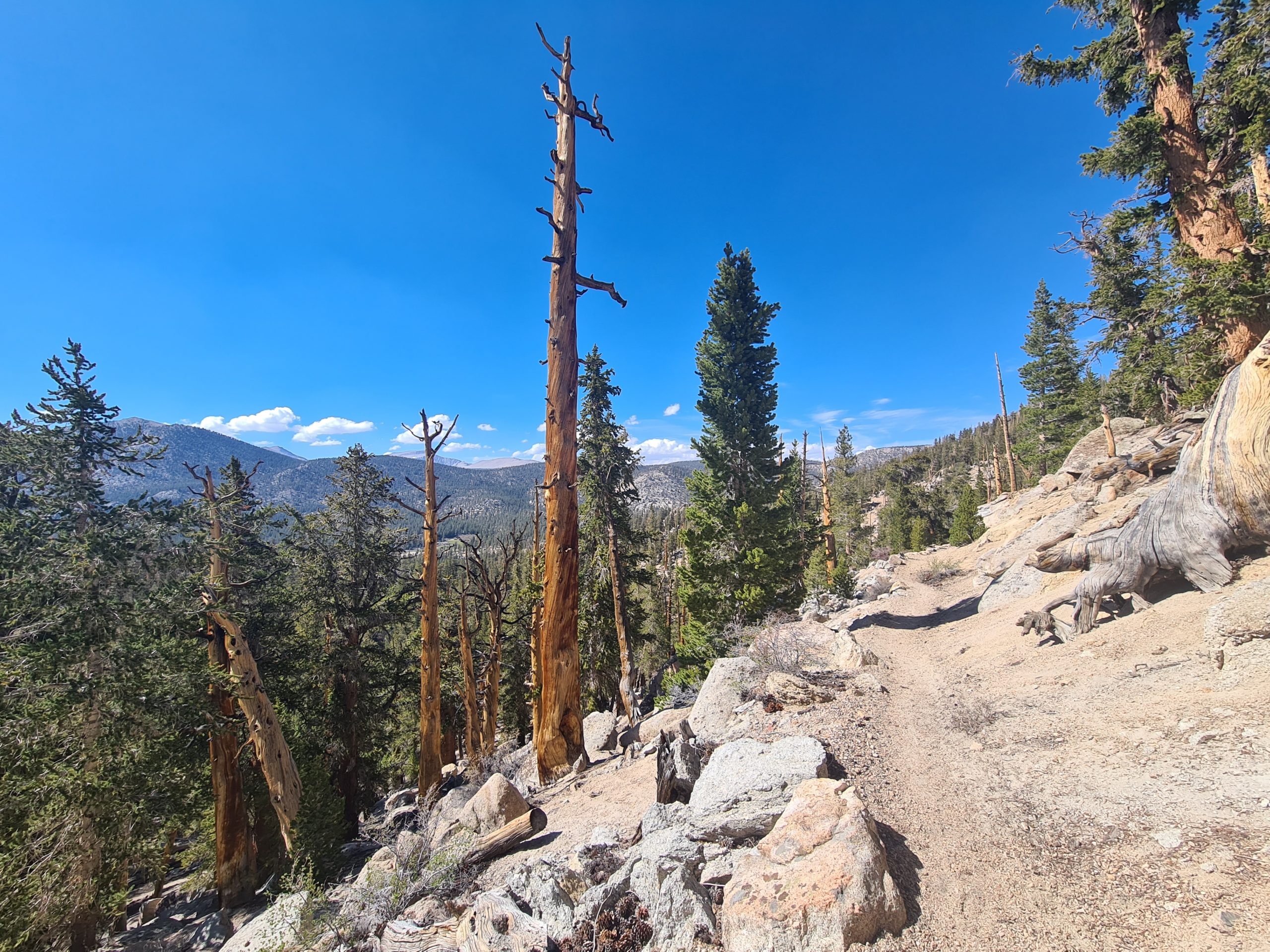
As I wake up I already feel better than yesterday and I’m ready to continue. The trail goes slightly uphill through rock-strewn conifer woodland close to the South Fork of the Kern River. My backpack is still heavy and after two or three kilometers it’s always getting uncomfortable. So I take more breaks today. We cross the river on a bridge and start a steeper climb to emerge in the valley with a lovely meadow where the river just goes right through. There is a perfect spot for a lunch break by a wooden bridge. We watch the swallows going back and forth carrying mud to build their nests. You can even have a little soak in the river, which I didn’t do today as I’m still sick.

The trail continues uphill through pine trees and has some occasional views of Olancha Peak that’s towering above us. We reach a little pass and then descend not far to a tentsite in the forest. We catch a glimpse of the sunset in between the trees and have the entire campsite for ourselves, spending the night over 3,000m (9,842ft).

PCT Day 42: Higher and higher
Mile 725 to mile 745.3
32.6km (20.2mi) / 7.5h / elevation gain of 934m (3,064ft)
Mosquitoes bit me on my face while I was sleeping and my left eye is swollen when I woke up. Welcome to the Sierra. The trail continues to go down just to go up to the next pass on 3,254m (10,675ft). Jet planes flying loudly over our heads, some doing tricks. On the way, we have a nice view of Owens River Valley, and an even better one from a rocky outcrop from the top. Owens River Valley has a mostly dry lake because of being drained as a water source for Los Angeles.

The trail is doing some ups and downs to go up towards the next pass where you can exit to Lone Pine. We are not doing that, but camping at the junction to the Trail Pass. Again we have the campsite for ourselves.
PCT Day 43: Going to Mount Whitney
mile 745.3 bis Crabtree Meadow
36.7km (22.8mi) / 9h / elevation gain of 1,110m (3,608ft)
Today we wanna push it all the way to Mount Whitney to climb it tomorrow morning. So we speed up a bit and do 12 miles by noon. The trail goes uphill to Chicken Spring Lake, a beautiful alpine lake, and standing here really feels like entering the Sierra. It would be a great place to camp for sure. We climb a bit higher and get nice views of the lake and a meadow in the distance. We then reach the Sequoia National Park Boundary, from where bear cans are required. As we carried six days of food we stored some of it outside of the bear can because not everything fits inside. I have no idea what to buy to fit as much in the bear can as possible. I guess I have to figure that out in the future.

The trail drops down just to go uphill again where a little bit of up and down follows and soon we can see Mount Whitney in the distance. We hike to the junction to Mount Whitney, where the trail goes slightly uphill to the campsite at Crabtree Meadow. It really is a nice spot to camp and a great base for climbing the 4,421m (14,505ft) peak. There is a bear box and a very special pit toilet. It’s free-standing with just a little one-sided tin sheet wall. It’s like a throne in the woods and feels quite public as there is no way to signal that it is in use. We are going to sleep early to get up very early to climb Mount Whitney tomorrow.

PCT Day 44: Summiting ice-cold Mount Whitney
Mount Whitney and back + further on to Wallace Creek (mile 770.3)
21.4km (13.3mi) + 8.4km (5.2mi) / 7h + 2h / elevation gain of 1,500hm (4,921ft) + 262m (859ft)
Climbing Mount Whitney is one of the highlights of the PCT, even if it’s technically not on the PCT, but a popular side trip. It’s the best possibility to climb the highest peak of the USA outside of Alaska as it’s hard to get a permit for this one.
We are starting the climb at 1:30 am. There is a river crossing at the beginning and it’s not that easy to get to the other side as the rocks are slippery from a thin sheet of ice. Getting wet feet would be deadly up at Mount Whitney as it’s gonna be cold. I’m not a fan of sunrise hikes. I climbed quite a few high mountains for sunrise and every time I was terribly cold. If it’s not really necessary for safety issues to go that early in the morning I just don’t do it anymore. But the others want to do the summit for sunrise, so cling together, swing together.
We start at an elevation of 3,244m (10,643ft) and have to go all the way up to 4,421m (14.505ft). As it’s dark I can only see the small spot that is lit by my headlamp. And millions of stars above us as well as the headlamps of those ahead of us. I can just hear my breathing and my crunching footsteps. Sometimes I lose the trail in the dark but can find it quickly again. We are passing a lake, but can’t see any of it.
As we are climbing higher and higher the trees retreat and we are hiking on switchbacks through rocky terrain, starting at around 3,500m (11,482ft). In the beginning, it’s not that cold, so I can get rid of my puffy soon. But the higher we get the colder it gets and I start putting on layer after layer. In the end, I’m wearing everything I have including my rain gear which helps with the icy blasts. I didn’t bring my trekking poles as I needed them for my tent where the rest of my stuff is. I just go with a light backpack with the necessities and it’s so much easier to climb up without a heavy pack. And I can put my hands into my cuffs to keep them warm.

And as long as I keep moving I’m feeling warm enough. After 8.6km (5.3mi) we reach the junction to the last push to the summit. The trail flattens and slowly the sky gets brighter so that I can turn off my headlamp and see the mountain landscape around me. Way below me there are some lakes and snow-covered peaks around them. I meander through some spiky rocky “Needles” on the last push to Mount Whitney. The sun begins to rise and I can see a band of light on the horizon. I hurry up to get to the summit in time for the sunrise and here I am.


Standing on 4,421m (14,505ft) and seeing it all. Unfortunately, it’s extremely windy and as soon as I take off my gloves to take photos they immediately go numb. (Note to myself: Buy gloves that can be used on touchscreens). So, I can’t fully enjoy the views. I have no idea how cold it really is, but it’s well under -10°C (14°F). The wind chill is extreme and it blows so hard that it almost blows my phone off my hands. I turn around for some quick photos and then seek shelter in the stone hut of the Smithsonian Institution. There is snow inside the two rooms, but at least we are out of the wind. I brought my sleeping bag and a pad up here and try to warm up.

But after just 10 minutes clouds roll in and take away any view. I was hoping that the sun will warm everything up and get a few more pictures, but instead, a sleet starts. We are waiting for one hour until The Italian arrives at the summit, too. We were wondering if he’s going to make it as we don’t know if he has anything other than shorts with him. But then he stands at the door, in his shorts. Crazy.

We take a quick picture together and then start to head down. I rush down the mountain as I want to get out of the cold as quickly as possible. My glasses are frozen from the sleet, so I need to hike without them. There is no view anyways. After reaching the junction again the clouds begin to clear and show the lakes below me. I descend all the way to a little lake where I stop and wait for the others.

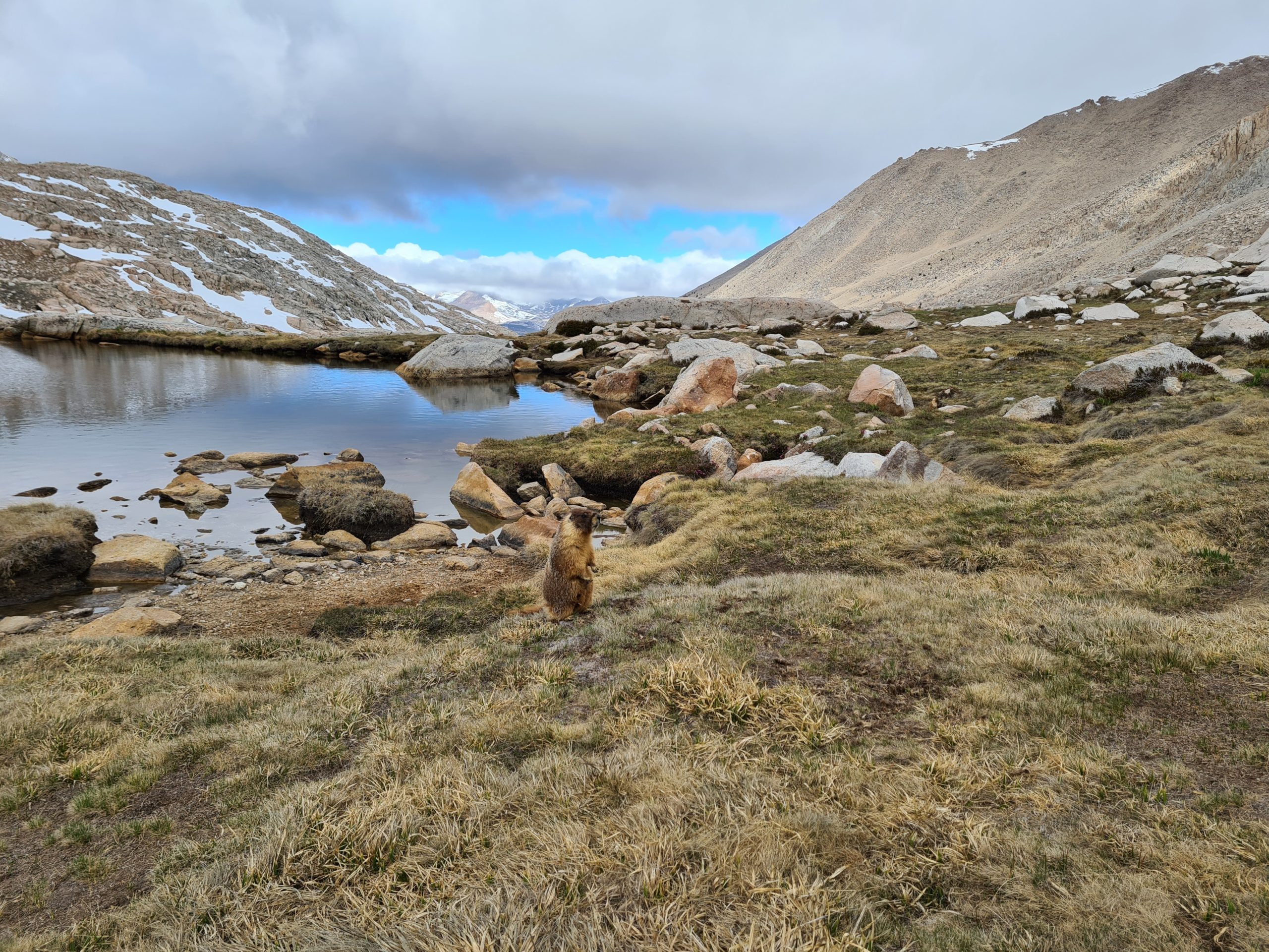
I’m here for like an hour and the sun slowly fights its way back through the clouds. Some giant marmots are running around this beautiful place and I watch them pretty closely. They don’t seem to be shy at all. There is also a nice view of Guitar Lake down below. From higher up, you could clearly see how the lake got its name. I regret that I did the mountain for sunrise as the weather is much more pleasant now. One day I might do Mount Whitney again during daylight, assuming I can get a permit.
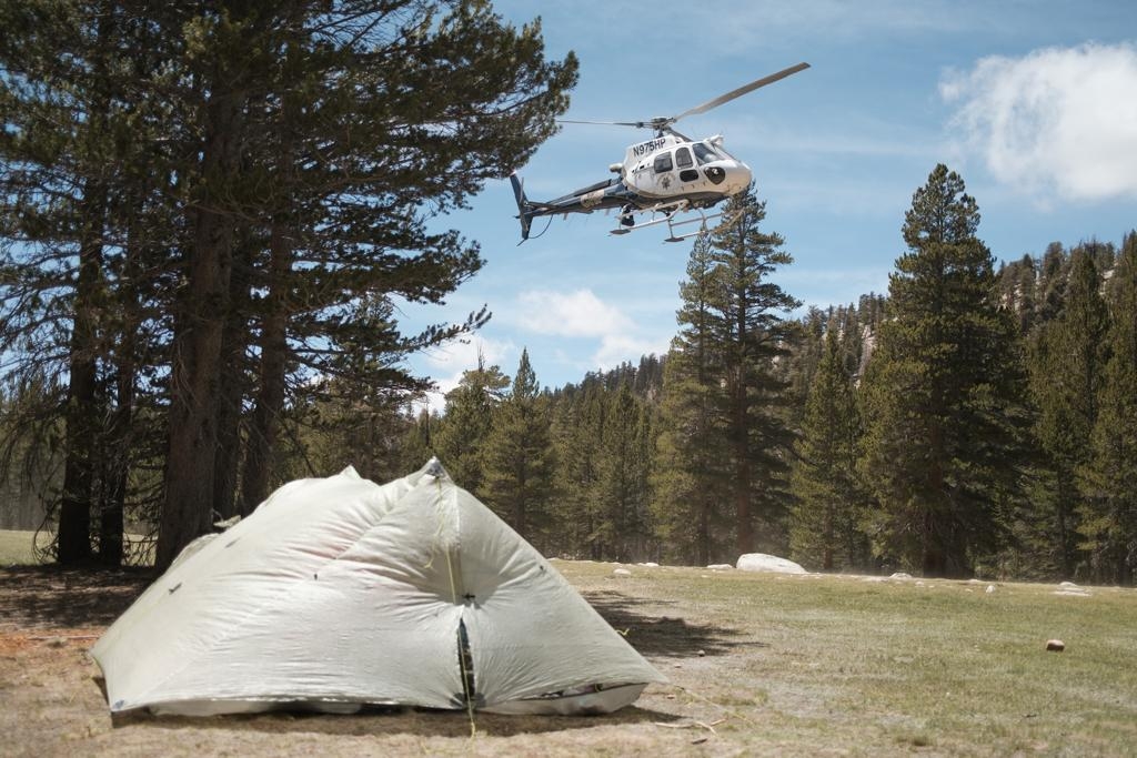
From here it’s like an hour back to the campsite where we arrive after seven hours roundtrip. I don’t feel tired at all, I’m actually full of energy. There is no possibility of taking a nap anyways as a helicopter is coming to evacuate someone due to altitude sickness. Our tents are at the edge of the meadow that is used for the landings and we quickly pack everything. I leave my tent there as I think it’s far enough away. When the helicopter finally arrives my tent holds up well, thank you zpacks! I think this was the ultimate test for the Duplex.
In the afternoon we get back to the PCT to walk another five miles to the tentsite at Wallace Creek. There is some more elevation to take in and I’m pretty exhausted and tired by now. Going uphill is a hard slog for me after all this elevation earlier and I’m very slow.

PCT Day 45: Going over Forester Pass – the best day ever
Wallace Creek (mile 770.3) to Kearsarge Pass Trail Junction (mile 788.9)
31.8km (19.7mi) / 9h / 1,564m (5,131ft)
It’s the coldest night I’ve ever experienced while out camping. Temperatures drop down to -6°C at the night. We also cowboy camped as we didn’t know that it’s gonna be that cold. First, my legs and feet get cold and I reach out to my backpack to get out my sleeping bag liner, which I bought over 900 miles ago and never used. It’s a bit better, but still too cold to catch proper sleep. So I wrap my puffy around my legs.
Somehow my upper body is relatively warm although I’m just in my fleece. I still wake up all the time because I’m feeling cold. I also dream about being cold. I’m counting the hours until daylight to get going. At around 5 am it begins to get a bit warmer so that I’m able to catch some sleep. Somehow my most miserable nights are always related to cowboy camping. So, no cowboy camping in the Sierra anymore.
All my water was frozen in the morning and it was hard to get new water as the opening of my cnoc bottle froze as soon as I put new water in. I forgot to take my water filter into my sleeping bag, so it might be broken now due to freezing. So I just put a chlorine tablet in the water as it’s too much of a struggle to handle the filter in the cold anyway. Also packing all my stuff with cold hands was a hassle. Somehow it doesn’t fit in my backpack as it used to and I can’t open my bear canister with cold hands.
I’m glad to finally start moving, but then the first river crossing comes up. It’s not that bad as there are stones to hop on over, but in the morning they are icy and slippery, but I manage to get to the other side with dry feet. Unfortunately not on the second river crossing. I can already see that this is gonna be a tough one and I get my right foot wet. Let’s put it that way: I’m not a happy hiker this morning with this bad of a start. I prepare for a mentally challenging day.
Then the trail starts to climb uphill and I’m able to get warmer. Suddenly I’m in a meadow with amazing mountain views and this almost makes up for all the troubles. With every step, the view gets better and better. There is a little lake and mountains all around me. It’s so beautiful, my heart opens and I’m in awe. It’s not possible to describe this. Everything else is forgotten now, even the cold wind that blows into my face. It’s hard to believe that we were on an even higher mountain than all these peaks around me yesterday.
The trail descends to another river where I get a wet right foot again (at least it’s the same one) and I stop for breakfast in the sun as this place is sheltered from the wind. The guys are also coming and telling me that they also got wet feet on the second river crossing.

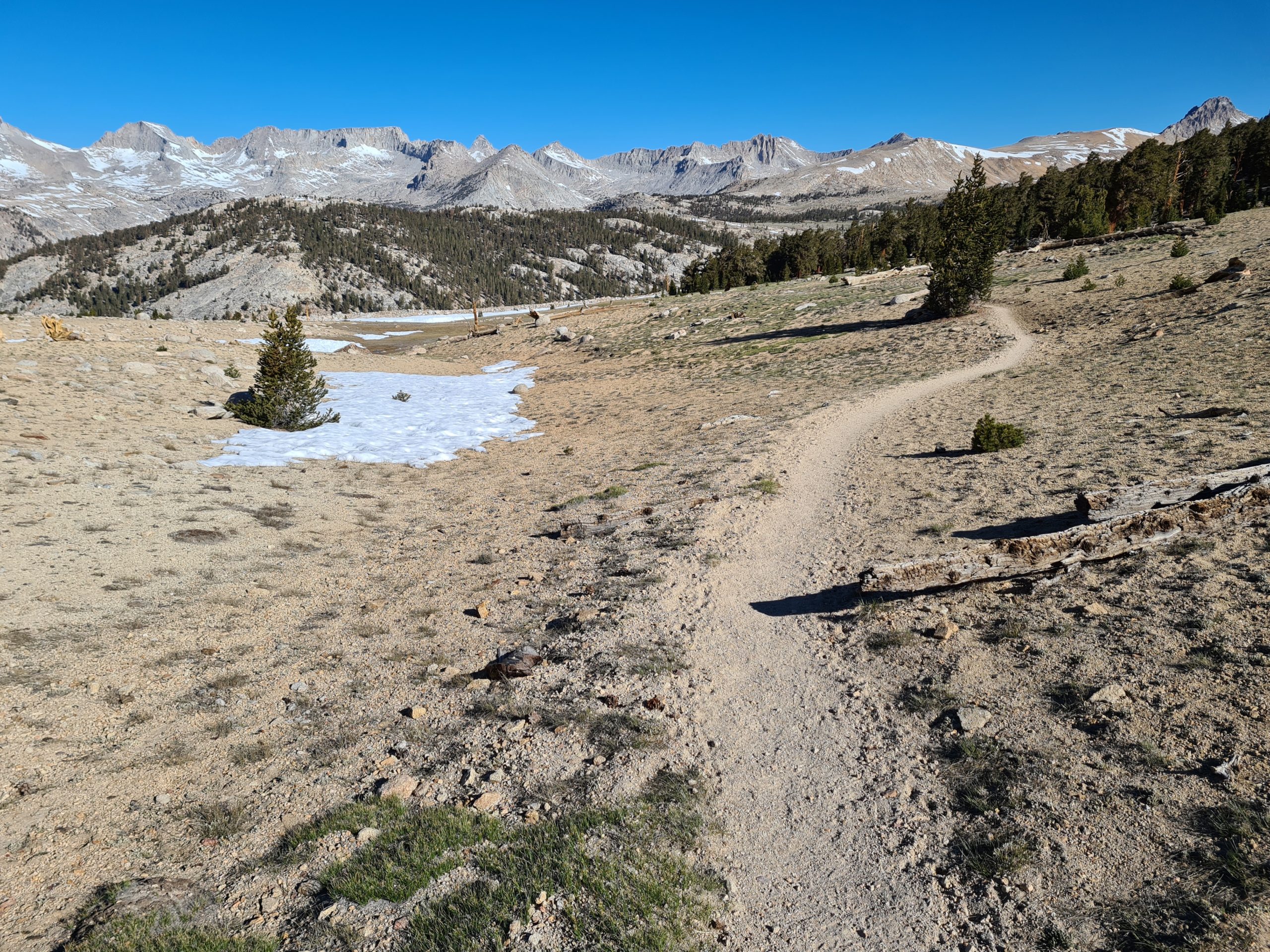
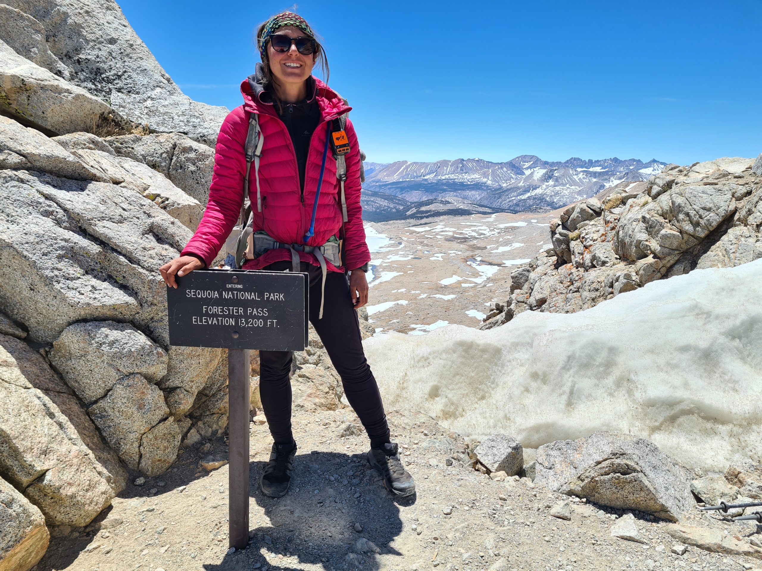
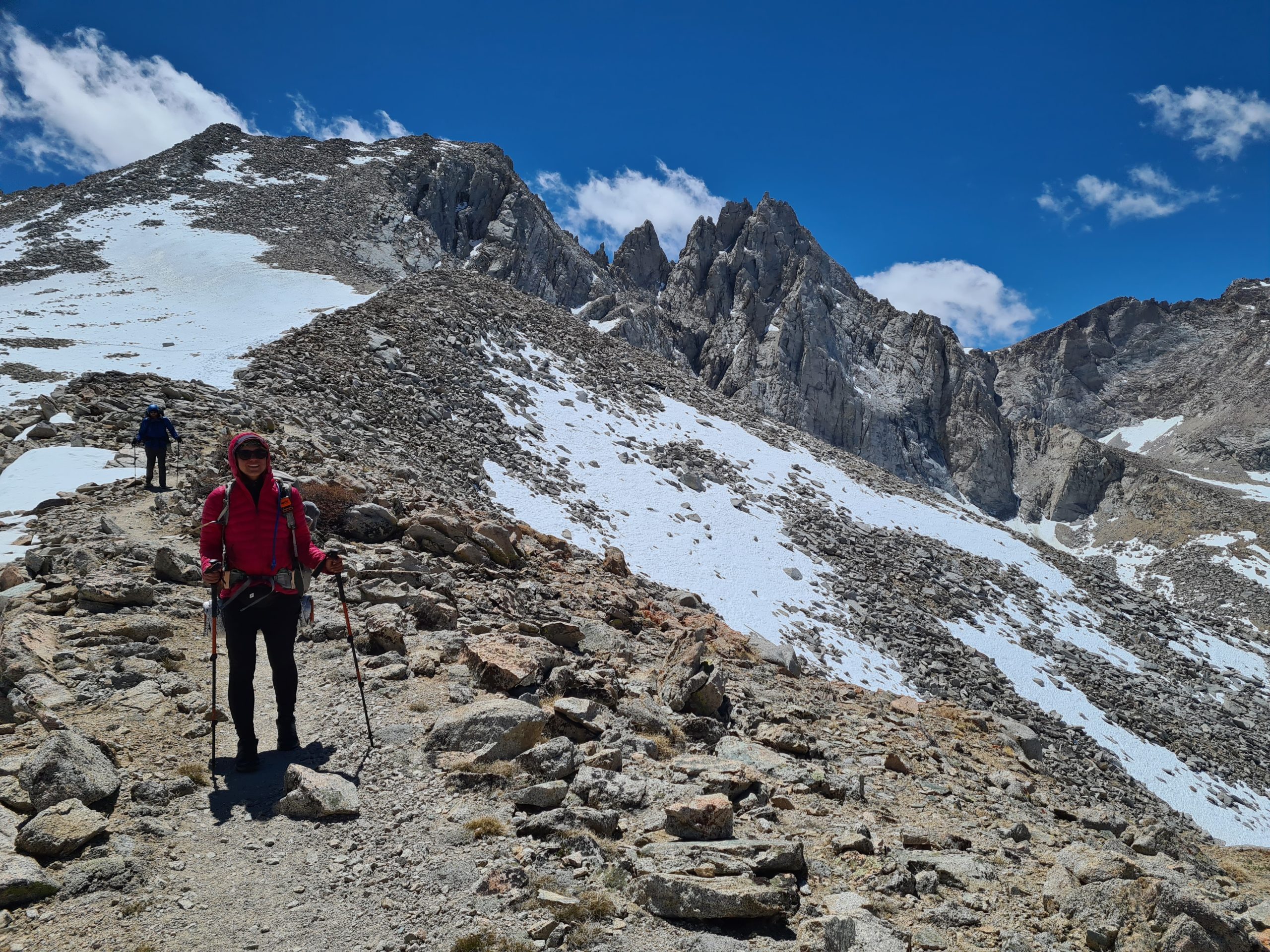
Now the big climb up to Forester Pass starts, at 4,000m (13,123ft) the highest point of the PCT. The area opens up again and we are passing lakes, gushing creeks, lots of marmots, and a waterfall. This is how I imagined the Sierra. There are some flat snowfields that are easy to walk on as the snow is firm and there is no post-holing. We are approaching a steep rock wall and I have no idea where the pass should be as none of these walls look like you can walk up there.


We do one more break until we tackle the final ascent up to the pass. The trail goes in switchbacks to the rocks to a little passage in between the granite walls. We have an amazing view down to the valley behind us with the lakes, some frozen and some open. There is no snow at all on the trail up to the pass and it’s an easy walk. We imagined that it would be cold and windy at the top but it’s surprisingly pleasant in the sun, so we are taking a lunch break. We are marveling at the views into the valley we are about to descend into.
On the other side, there is quite a lot of snow and we even can do some glissading on our butts. My pants are wet after it, but it was well worth the fun. It was also the easiest way to descend through the steep snow. The trail meanders all the way down, passing some more lakes, snowfields, and epic views. There is an abundance of water everywhere, no big carries are needed anymore. We are finally reaching the forest again. Interestingly, there seems to be no transition zone. The trees just reappear without any signs of low shrublike mountain pines as they are in the Alps. There is a river crossing where we balance on a log above the river to keep our feet dry, which looks a bit sketchy to me. But Popeye takes my backpack and so it’s easier for me to do.
We have one more climb ahead of us today to get to the junction where we are going to leave the PCT to go to Bishop for resupply. We are flying up the mountain in no time and we are proud of how strong we became. At one point we have a stunning view into the valley below us and the mountains on the other side. The trail goes back to a forest and we take water from the last water source before our planned camp. Shortly after, three deers are running over the trail just in front of me. It’s awesome how close you can get to the animals here as they are not shy.


We reach the junction to Kearsarge Pass Trail at the top of the pass and leave the PCT. We don’t have to walk far until we find a nice grassy campsite sheltered between rocks. This time we put up our tents and hope that this night will be better than the last one. I put all the clothes on I have, including my rain pants. When I rolled out of my sleeping pad I still found snow in there from the glissading through the snow. It was too cold to melt today. It was the first day I was hiking with my puffy all day long. But it still was pleasant and actually the best day on the trail so far as it was so entertaining that I didn’t even count the miles.

PCT Day 46: Exiting over Kearsarge Pass to Bishop
Kearsarge Pass Trail to Onion Valley and then hitch to Bishop
12.2km (7.5mi) / 3h / elevation gain of 351m (1,151ft)
Actually, the night was way better than the last one. It still was -6°C (21°F). but I was much warmer. The water was again frozen in the morning. We start to approach Kearsarge Pass and it’s beautiful as we can see some lakes below us with lots of snow-covered mountains around us. After one hour we reach the top of the pass at 3,569m (11,709ft). It was windy on the way up here, but at the pass, there is no wind anymore and it’s nice and sunny, so we make a breakfast stop.

Now it goes all the way down into the Onion Valley, knowing that we have to hike all this up again after our zero day in Bishop. But it’s so beautiful and there are a lot of switchbacks that are not steep. We are descending almost 800m (2,624ft), passing more lakes, rivers, and a waterfall. I can’t get enough of these views. Now I know what all the excitement regarding the Sierra is about.

We finally reach the Onion Valley parking lot and wait to score a ride to Independence. The Italian gets a hitch right away and Popeye and I have to wait a little bit longer but we just get to Independence in time to catch a hippie bus that’s taking nine of us stinky hikers in to drive to Bishop. As there is not much in Independence, Bishop is the better resupply choice. We now went down over 2,000m (6,561ft) from the pass and my ears don’t like that as doesn’t my nose. Both get congested on the way down.

We reach Bishop by lunchtime and have time to get food, do laundry, and check out the gear store. There is a gear exchange store where you can get second-hand stuff and they even have a 20% discount on new items. I get an ice axe here for the upcoming section, new tips for my trekking poles (of which I manage to get one off, the other one doesn’t want to even after soaking it in hot water for 30 minutes), and a second-hand long sleeve as a replacement for my holey one.
Later in the evening, we go out for drinks and then go bowling with lots of other hikers. It could be a great evening but somehow I managed to delete all my notes from the last eight days on my mobile phone. I’m so upset about the loss of the hours of work and trying to recover them that I can’t enjoy the evening like the others, which is such a pity. I couldn’t restore them, so I have to rewrite everything. This is also part of the life of a blogger.

This website contains affiliate links, which means The Trek may receive a percentage of any product or service you purchase using the links in the articles or advertisements. The buyer pays the same price as they would otherwise, and your purchase helps to support The Trek's ongoing goal to serve you quality backpacking advice and information. Thanks for your support!
To learn more, please visit the About This Site page.
