 ">
">
Planning a Route For 300+ Mile Chinook Trail Thru-Hike
So I have decided to do the Chinook Trail. I have two to three weeks of vacation time, have my gear and money saved up to cover expenses. The next step, it seemed, was to download a map of the route. Since so few people have completed the trail, there isn’t a Guthooks or Halfmile’s map or app available. I figured the Chinook Trail Association would have an official route map, either online or print. Instead, this is what you’ll find on their website (actual size):
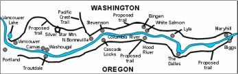
Now I don’t mean this as a slam – they are a small but determined group that really want to see the Chinook Trail become a popular, established thru-hike option. They have done amazing work on the Washington side with trail maintenance, and have been super-helpful with me since day one. But this tiny little JPG image is the only map they have on their website. Their “resources” page does include links to sections of the trail, as well as links to pages from people that have completed the Chinook Trail. However it was pretty obvious that I’d have put together a detailed route on my own using this JPG as a guide. This seemed easy at first and completing the route using the Gaia app only took a couple of hours. However, once I began looking at my intended route carefully there were a few problems that would have to be figured out.
The Washington Side of the Trail – A Few Alternate Routes Needed
Thankfully, the first 100 miles or so are pretty straightforward – it’s all trails and forest roads and really the only thing to sort out is which of the trails is the best to take near Silver Star Mountain. The trails and roads in this western section hook up nicely, and as the Chinook Trail Association is based primarily in Vancouver, WA, they have been extremely helpful with this section of the hike with advice and recommendations. It also meets up with the PCT, so I included a 17-mile section that heads east and includes one or two camping options.
Klickitat Trail Alternate Route
The first problem area is the Klickitat Trail, which is a 31-mile section (about 10 percent) of the Chinook Trail. The first half is open year round and includes one or two camping options. However, the second half goes through Swale Canyon, which is subject to an annual fire closure, usually July through mid-October. As I am leaving Oct. 1 this is an issue – unfortunately, it means I’ll need to take an alternate route, which involves about 15 miles of road walking. Interestingly, I found out that the Swale Canyon fire closure isn’t because of current or past fires – it’s because if there is a fire, there are no easy ways out of the canyon. There is a small chance that Swale Canyon might be open upon arrival at the start of that section, but I won’t know until a week or two before getting there.
Maryhill, WA, Alternate Route
The next problem area is the approach to Maryhill, WA, the eastern end of the Washington side of the trail. If you use Google Maps you’ll see a small dirt road that offers the most direct route from a bluff covered with wind turbines down to Maryhill on the Columbia River. This road was in my plan for two weeks, until it dawned on me that I should check Google street view where the road meets Highway 14. Sure enough, there’s a gate – and the whole road is private property, partially owned by the Maryhill Museum. I contacted them and received permission to walk the bottom part of the road, but they said I would need to contact the landowner for the upper portion. It took over a month, but I finally made contact with him, and now have permission to walk the entire section, just needing to hop a couple of gates and fences along the way.
The Oregon Side of the Trail – A Huge Detour Becomes an Opportunity
The biggest issue I faced though was figuring out a way from Hood River, OR, to Portland, OR, with nearly all of the Mark O. Hatfield Wilderness closed due to the horrible fires last year. Using the Gaia app, it was pretty easy to put together a route of forest roads to go around the fire closure to the south. That wasn’t going to work either, though. I found out several weeks later that my route goes through the Bull Run Watershed, which supplies the drinking water for Portland and is closed to recreational use. So I’d have to go south of that as well.
This temporary roadblock became an opportunity, though, as I was able to finalize my route by going south on the PCT and turning west after passing the western slopes of Mount Hood. The timing will allow me to attend one day of the ALDHA-West Gathering – it’s a 20-mile round-trip detour, but seems well worth it to meet up with fellow thru-hikers.
Overall, my intended route has grown from 263 miles to just over 300 miles. However, as these adjustments were made it cut down on the amount of road walking to do in eastern Washington. It also includes more PCT miles, includes an overnight at Timberline Lodge on Mount Hood, and I can attend the ALDHA-West event. I’m about a month away from my start date, and there will undoubtedly be a few more subtle changes to make, and may even change it up while on the trail. At this point, though, my thru-hike will follow the 300+ mile route below:
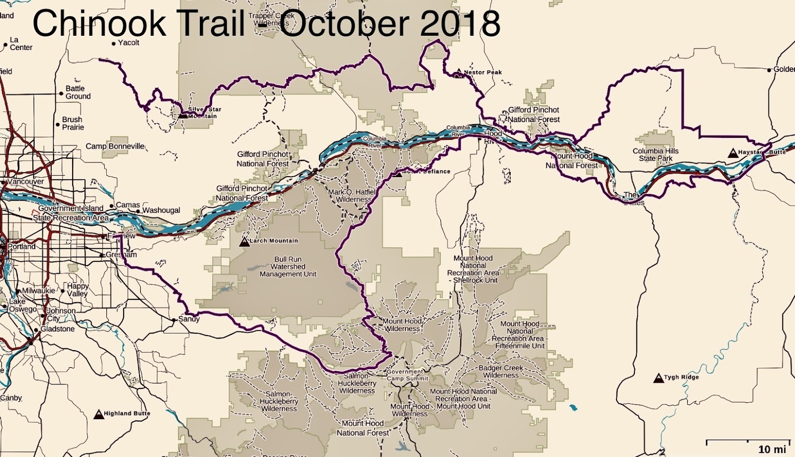
Final Chinook Trail route plan. Subject to change?
(Feature image courtesy of the Chinook Trail Association)

This website contains affiliate links, which means The Trek may receive a percentage of any product or service you purchase using the links in the articles or advertisements. The buyer pays the same price as they would otherwise, and your purchase helps to support The Trek's ongoing goal to serve you quality backpacking advice and information. Thanks for your support!
To learn more, please visit the About This Site page.

Comments 1
Sounds promising. Look forward to hearing about your journey! @HikeWithHeart