 ">
">
Ridge Walking the Carnic Alps-Reverse Route
The Karnischer Hohenweg or “Carnic High Trail” is a well-known alpine long-distance hiking trail in the European Alps that traces the Austrian-Italian border. Traditionally it runs from Sillian Austria near the Tirolean Alps in the west to the Thoerl-Maglern area in the east just south of Villach Austria. The hike is generally done from West to East in 8 to 11 daily stages. Hikers on this trail encounter everything alpine, from idyllic alpine pastures and dense Austrian stone pine forests to barren mountain meadows, rubble dumps, rocky mountain paths and adventurous peaks. Much of the trail is a ridge walk, as the hiking trail runs along the main ridge that separates the two countries. Hikers are treated to fantastic views of some of the range’s most powerful peaks, including the Sesto Dolomites, the Julian Alps, the Hohe Tauern and the Gailtaler Alps.As is normal for me, I have a way of doing things ass-backwards. Since I generally only get to make one hiking trip to Europe each year and due to the desire to include a second hike of the Alta Via 1 (AV1) through the Italian Dolomites, I decided to hike the Karnischer Hohenweg in reverse from East to West. Once I complete the Karnischer Hohenweg, I will have one day’s rest and only a 32km train ride to the beginning of the AV1 hike. Due to time constraints however, I will only have 7 days to complete the Karnischer Hohenweg hike which will necessitate doubling up on some stages.My hike on the Carnic High Trail will include around 111 miles (178 kilometers) through the mountains, forcing me to contend with a total of around 56,000 feet of elevation change. Fortunately, the altitude difference is evenly distributed over the stages with countless smaller summit ascents making up much of the altitude gain. The ascents and descents are balanced through much of the trail with elevation ups and downs of generally less than 7000-8000 feet per day.The Carnic Alps are a geologist’s wonderland. The area is one of the better preserved Palaeozoic sequences of the world. This narrow region underwent compressional as well as extensional deformational events which originated a complex structural framework of folds and uplifts. Fossils, mainly bryozoans, brachiopods, trilobites and gastropods are abundant.While on the hike, I’ll cross the border between Italy and Austria over and over again since the border of the two countries is the ridgeline.During World War I, the main ridge was the front line and soldiers’ cemeteries, bunkers and fortified positions are still visible along the trail. Since the end of the war the route became known as “The Carnic Peace Trail” and an outdoor museum is maintained near one of the assessable passes along the trail by the governments of the two countries. Hikers still often find remnants of the battles that took place during the war.There are high Alpine huts and guest houses along the trail where hikers are accommodated. The Austrian Alpine Club of which I am a member is responsible for many of these huts. Huts are sparse and hikers need to carry provisions for much of the period on the trail
.


Carnic High Route – Stage 1
Thor-Maglern to Nordio Deffar – Reverse Karnischer Höhenweg
Ascent 1,770 m Descent 940 m (or approx 9000 ft of elevation change)
I caught the 5:15am train from Villach to Arnoldstein to get an early morning start on my trek.
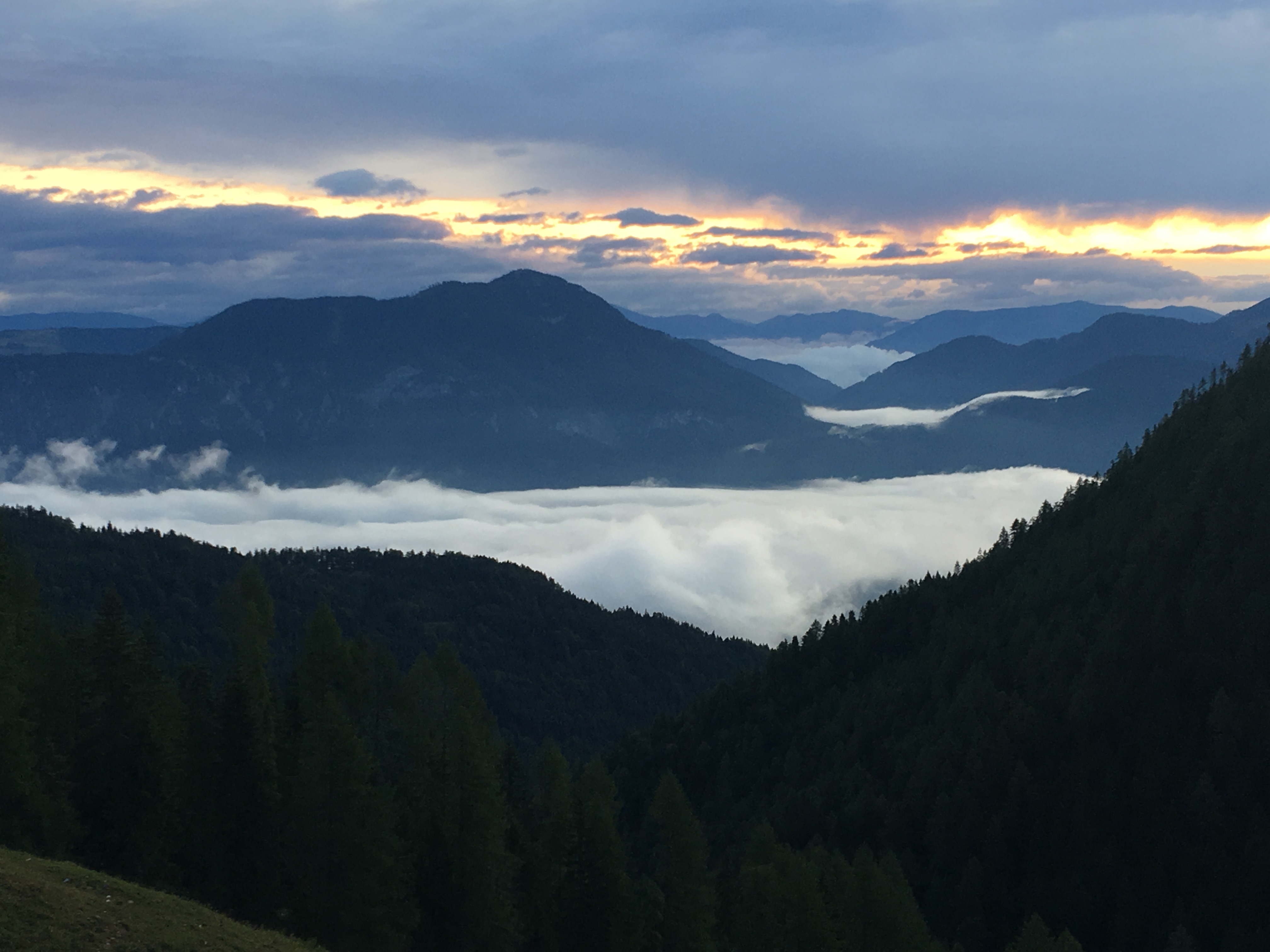
During the first stage of the Karnischer Höhenweg, I was mostly walking on good paths upwards through forests as I headed up the broad mountain ridge, but the long ascent from Thoerl Maglern to Göriacher Alm (Alm means alpine pasture) was certainly a challenge. I followed the 403 route as I progressed upwards from the Klagenfurt basin. The trail continued steeply upward and about 3500 feet of elevation change awaited me in the first 5-6 kilometers.
I did make a short detour to the viewpoint at an area called “hawk view”. From this point the Italian, the Austrian and the Slovenian mountains offer a marvelous alpine panorama.
I then hiked up the Kapinberg mountain which trashed my fresh legs. Along the ridge, the trail continues between the trees to the Göriacher Alm.
When I came out of the forest I was rewarded with a great view. On the other side of the broad Gailtal valley I got a wonderful view of the striking rock face of the Dobratsch mountain range and could see to the east where the mighty Klagenfurt basin opens. The strikingly straight furrow of the Gailtal Valley is part of the Periadriatic seam , which separates the Southern Alps from the Central Alps for those of you interested in geology.
The next few kilometers took me directly over the Carnic Ridge. From there the trail goes into a wide, quiet forest area but has a steep decent. The trail is not well marked in this area. The path winds down until you reach the Bartolosattel mountain pass which is covered with picturesque meadows and then scales back upward to the Almdorf of Achomitzer Alm.
This area is too Alpine to have much of a tick problem and I encountered no mosquitos but Austria makes up for it in ants. They were everywhere (reminds me of the last Indiana Jones movie) on the forest floor and their ant hills are huge (see photo).
The area also has a growing population of European Brown Bears for which they have signs posted to be aware of.
The 403 route that I am walking continues here into the Freistitzer Alm which has a large number of chalets. The old power station there which was uninhabited for a number of years is now called the Fledermaushaus (Bat House) and houses a colony of small horseshoe bats which can be observed inside the building. After walking through a wooded brook valley I again crossed the border from Italy to Austria and then arrived at the Dolinza Alm where I said so long to an Austrian couple that I had hiked most of the afternoon with.
From there I went downward and back into Italy where my hutte for the evening was located (Rifugio Nordio Deffar). After a quick shower, the hutte caretaker served the group staying there an excellent meal which put this tired hiker to sleep.
Carnic High Route -Stage 2 Rifugio Nordio Deffar to Nassfeld – Reverse Karnischer Höhenweg
Ascent 1,530 m Descent 1,350 m (or approx 9500 ft of elevation change)
I chose the Italian Route for today which almost proved to be my undoing. The Club Alpine Italiano (CAI), doesn’t maintain their trails on this route like the Austrian side does and I found at least four trails blocked by avalanches. Several of these I scrambled across (not recommended) and others were so blocked that I had to backtrack. Many trails were blocked by fallen trees also. I did not encounter another person until I was near the final hour of today’s 15 hour hike.
From the Rifugio Nordic Deffar I followed the route 403 as the Karnische Höhenweg led me steadily uphill through hiking paths and farm roads. I then crossed a small forest and some narrow alpine meadows and the path continued but took a downhill grade.
From there I crossed the border into Italy and accented several steep peaks before losing the trail near a river crossing. With my phone battery running low and no cell service I had to guess on the direction of the route which led me to a risky climb near a washed out WWI river bridge. I eventually found an mining old road (probably from the 1800s) that led me back to a trail marker for the 403 route.
As I continued through the forest I saw several signs that warned of bears in this area. The European brown bear which can weigh up to 650-750lbs is making a comeback in Austria but they rarely attack people. Their diet consists of about only 25% meat and so far there have been no reports of hikers being included in that percentage.
Near the Schultersattel ridge I crossed the border back into to Austria. A final decent awaited me right at the end between Gartnerkofel summit and Garnitzenberg as I headed down to the Nassfeld pass.
In 1799 a botanist named F. X. Wulfen discovered on the slopes of Gartnerkofel an endemic flower, now named after him (Wulfenia Carinthica). In Alps this is the only place where it can be found. Early in summer each year a day of wulfenia is held when local residents go out a search for the flower.
My accomodations for the evening were The Alpenhof Platner in the Austrian ski area of Nassfeld.
Carnic High Route – Stage 3 Nassfeld to Zollnersee Hütte – Reverse Karnischer Höhenweg
Ascent 1,060 m, Descent 940 m (or approx 6600 ft of elevation change)
The third stage takes you through the picturesque mountain meadows that characterize the landscape of the eastern Carnic main ridge. While it begins with a steep climb out of Nassfeld, there are also slight elevation changes of a few meters or more on this long stretch of almost 24 kilometers.
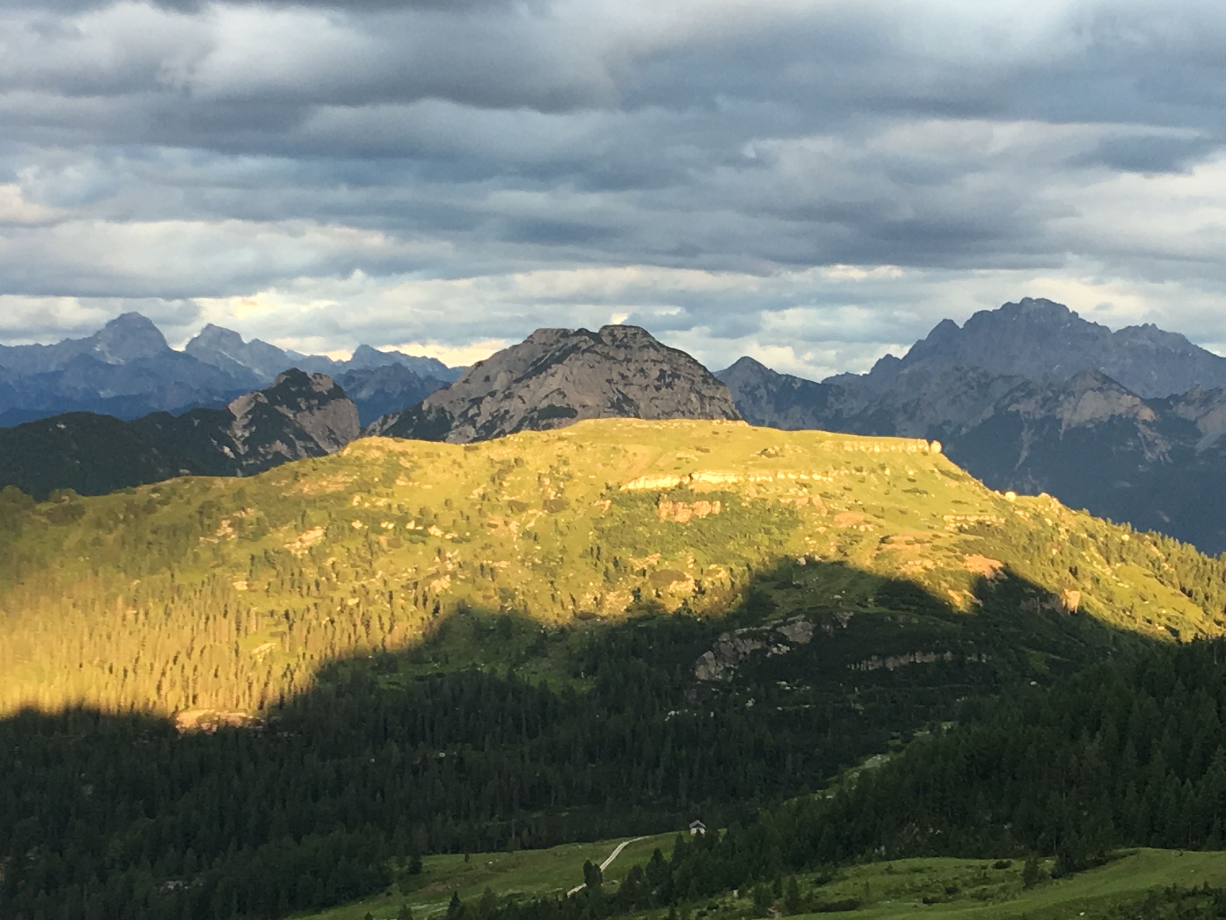
From the Alpengasthof Plattner, I hiked through the meadows and villages of Nassfeld up the slope of the ridge and over the summit of the Madritsche where there is a ski station. Here the Karnische Höhenweg runs through a depression on the northern slope. At an area called the Rudnigsattel you finally cross the pass between the Trogkofel and Hinterrosskofel summits (see photos). At the striking rocky summit of the Trogkofel you pass on a narrow path to its impressive southern flank.
The Trogkofel area was a deadly area during World War I as the front lines of the Isonzo front converged here. Ernest Hemingway’s book A Farewell to Arms is partly set in the events along this front. There are many remnants of the war that remain along this part of the route.
From here you continue around the summit group of shoulder and ring wall on a moderate decline from Italy over the Rattendorfer Sattel to rejoin the ridge.
The path then led me just south of the cliffs of the Ringmauer summit (so named because of its resemblance to a coliseum). The path then follows a shallow side summit of the Karnischer main ridge down through a sparse mountain forest.
The path then winds along the broad ridge and soon opens up the view of a wide, hilly plateau. This plateau forms the pastures of the Straninger Alm. The farms in the village offer direct purchase of their world famous gailtalian cheeses and dairy products and feature a cheese tasting every Tuesday and Saturday at 3pm (unfortunately I was here on a Sunday).
Past this a contouring path that is narrow in some places runs for about 2km below the Waideggeralm-Sattel and then up to the Nobling Pass. I then passed the Zollnersee lake, which makes a wonderful photo opportunity against the mountain backdrop.
My accommodations for the night were at the Zollnersee hutte Where a well deserved beer was the order (it’s good to stop inflammation)!
Carnic High Route – Stage 4
Zollnersee Hütte to Wolayersee Hütte– Reverse Karnischer Höhenweg
Ascent 1,770 m, Descent 1,560 m (or approx 11,000 ft of elevation change)
The fourth stage of the Karnische Höhenweg forms the transition from the quiet alpine landscape of the eastern part of the long-distance hiking trail to the rough high mountain landscape of the western section.
From the Zollnersee hut, the path snakes over the mountain pastures and barren mountain meadows on the northern slope of the Carnic ridge. From the valley, I hiked past the Koder Alm and up to the summit where the trail goes parallel to the main the slopes of ridge.
At the Köderkopf I reached the highest point of the day’s stage and enjoyed a magnificent view of the Carinthian Mountains and the peaks of the Karnien main ridge.
The path then goes steadily downhill through mountain forests and sun-kissed mountain meadows as the Carnic mountain trail meanders toward the pass, parallel to the main ridge, through the valley of Angerbach.
This is a very adventurous decent directly down to the Plöcken pass from the main ridge. The surrounding landscape became more barren the further I went. I then followed the path to the Plockenhaus down through a small woodland and over the final mountain pastures. My knees were continually pounded on this long downhill section.
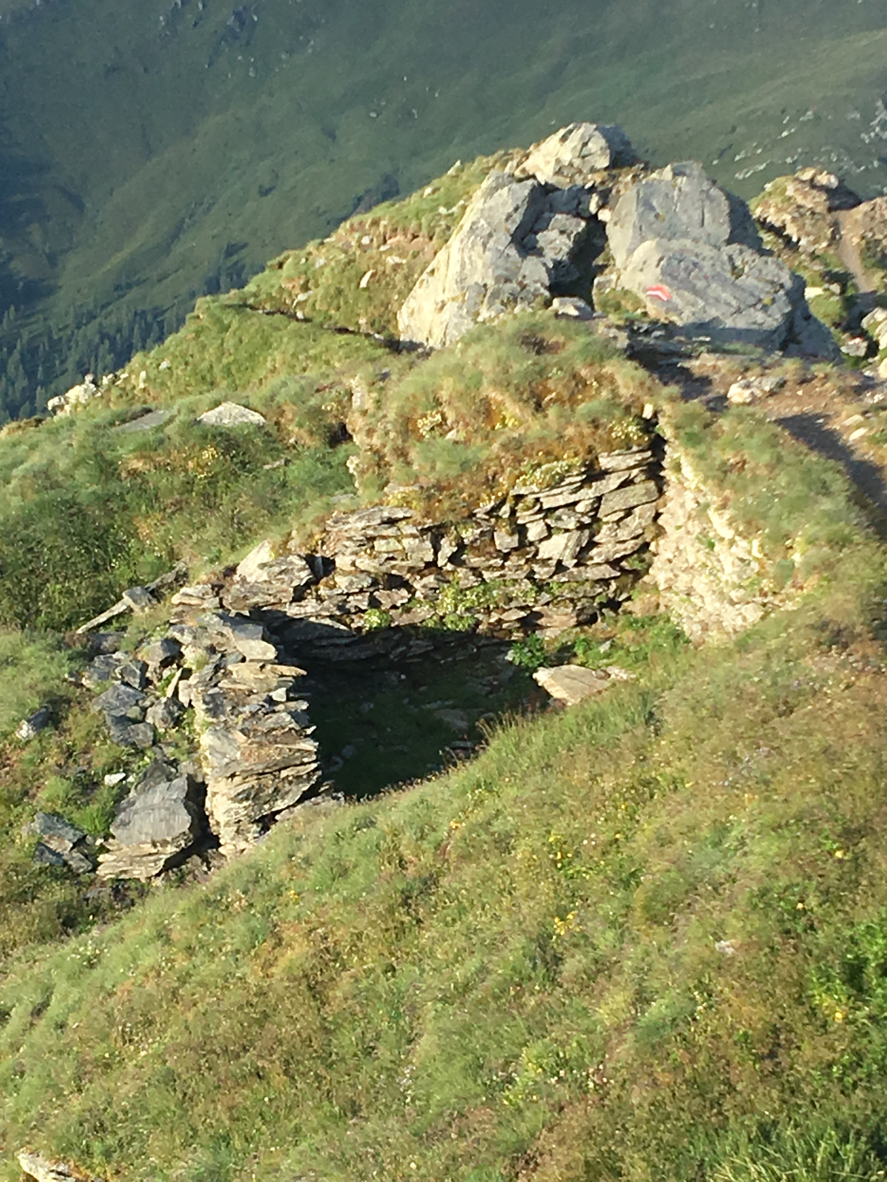
The Plockenpass dates back to early times as an ancient trade route. In 15 BC Roman general Tiberius rebuilt the road to reach the recently conquered lands north of the Carnic Alps. There is an open-air war museum here at the border (2km north of where you cross the road but bus service is available) that is free to the public and contains substantial trench works and fortifications from World War I (see photos).
I continued on past the Gasthof Valentinsalm in a steep climb to the pass that has stunning views in both directions (see photos).
Along the way the alpine flora and wildlife was in full view. The marmots are unique little creatures that resemble the gofer from Caddyshack. They usually are very skittish unless you have Snicker bars!
My stay for tonight is Wolayersee Hütte which sets right on a high alpine lake. The lake dates back to the last ice age and was formed by a collapsed sinkhole. The water in the lake is just above freezing but that doesn’t stop overheated hikers from attempting a swim.
With 11,000 feet of elevation change (1/3 of the height of Everest) this day was the toughest on my legs so far.
Carnic High Route- Stage 5 Wolayersee Hütte to Hochweißsteinhaus – Reverse Karnischer Höhenweg
Ascent 840 m, Descent 920 m (or approx 5800 ft of elevation change)
On the section between the Hochweißsteinhaus and the Wolayersee hut, the Carnic High Trail leads through the picturesque Val Fleons, an untouched high valley on the Italian side of the ridge. The trek lets you enjoy the view of the towering rocky peaks above you.
After leaving the hut I headed uphill northwest along the trail along the northern slope of the Carnic Ridge to the junction with a dirt road. The route then looped around to the east below the Kreuzleithohe ridge and through a boulder field to the Giramondo Pass where I reentered Italy. This area is ripe with ruins from old WW1 fortifications.
After going through a second pass (Passo di Niedergail) the shores of the small mountain lake Lago Pera appeared just below the path (skinny dipping certainly appealed to me at this point).
The valley continues for a ways and then the long descent from the pass Sella Sisani begins with great views of the Carnic ridge. After passing a couple of farmsteads, the path then led back upwards to the Ofner Joch pass which features a statue of a shepherd bringing home a lamb.
I then crossed back into Austria and I hiked downhill to the Hochweißsteinhaus Hutte. The hot water in the shower at this Hutte stops after two minutes and then turns freezing cold but the food was excellent. I got to eat dinner with two seasoned Austrian hikers (Walter and August) that were roping up the peak the next day. They were both 72 years old!
Carnic High Route – Stage 6 Hochweißsteinhaus to Filmoorhutte– Reverse Karnischer Höhenweg
Ascent 1380m, Descent 980 m (or approx 8100ft of elevation change)
This section is a real tightrope walk. Almost the entire route of this third stage runs directly along the summit ridgeline of the Carnic ridge. In the constant ups and downs the walk is on narrow rocky paths to the numerous peaks along the way.
The flora is amazing with natural high mountain roses in bloom and the edelweiss in abundance. I did see my first snake of the trip which the hutte proprietors have informed me are quite poisonous.
From the Hochweißsteinhaus I wandered through a breathtaking high valley up to the ridge path. Once I reached the Luggauer Sattel it was a border walk for much of the day with one foot in each Austria and Italy.
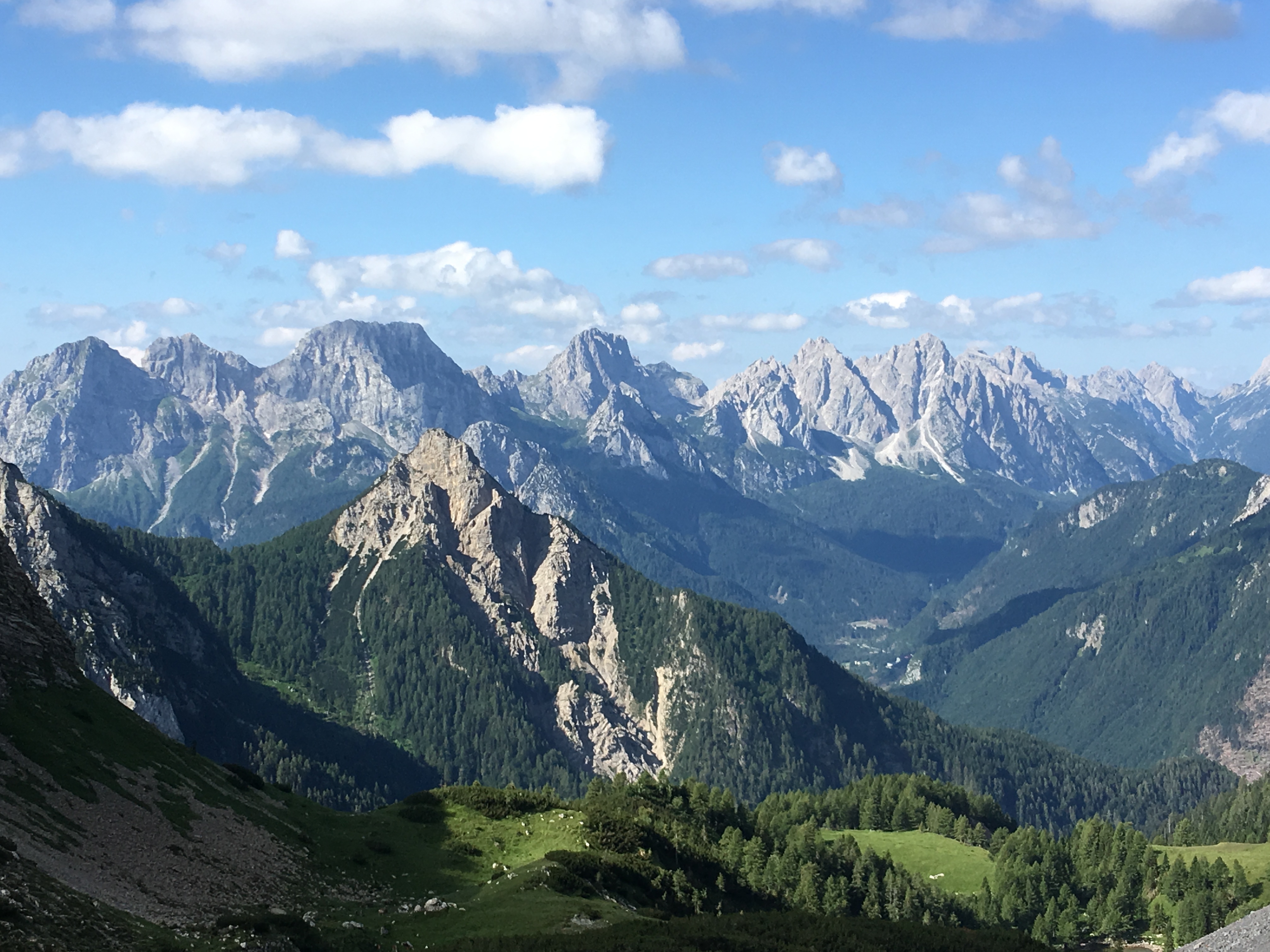
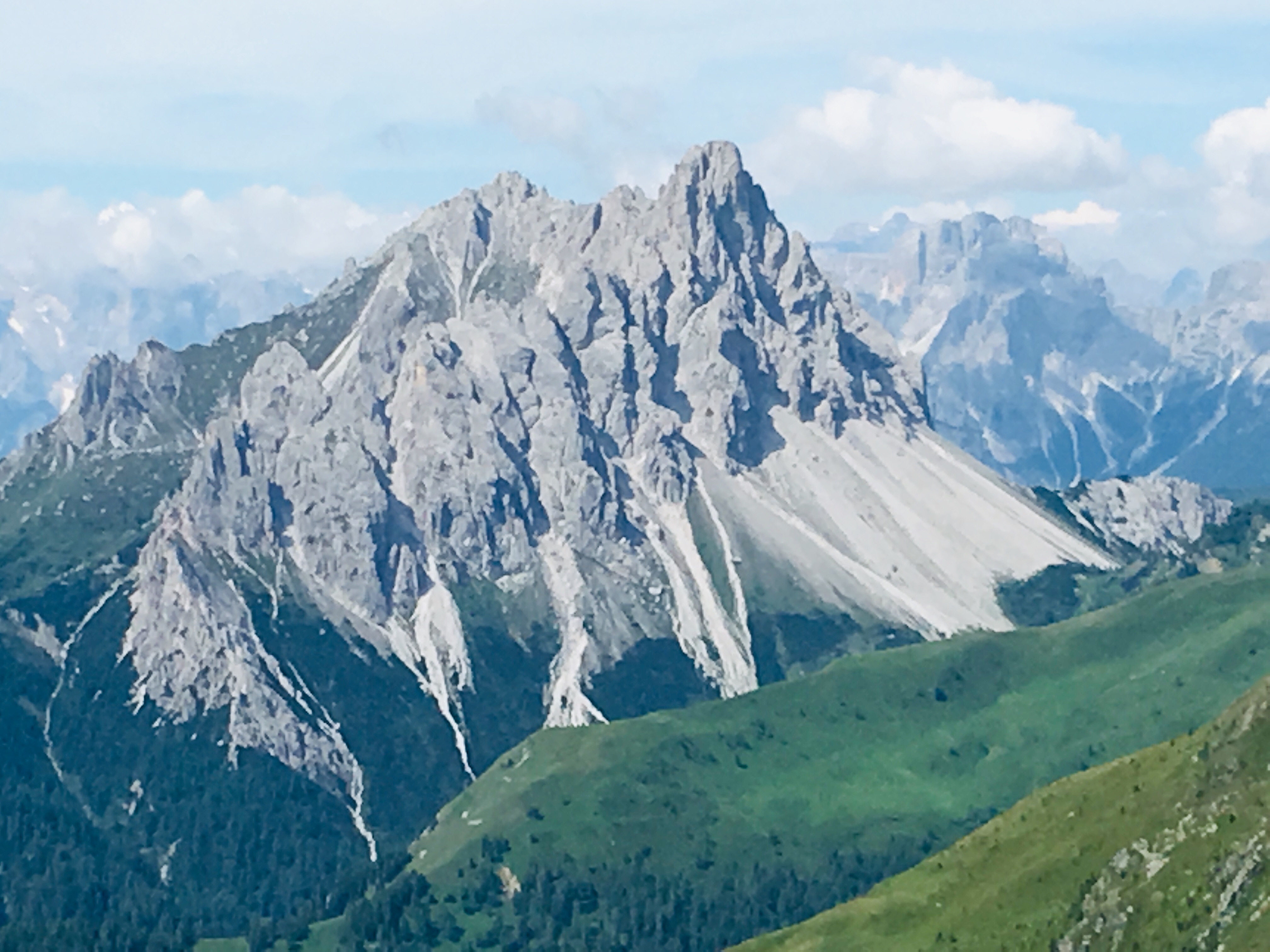
The path first headed uphill to the waypoint to reach the Steinkarspitz. At 2,524 meters, the summit was the highest of today’s stage. From here there is a great view of the mighty summit of the Hochspitz (see photo). There is no direct access to the summit here, so the Karnischer Höhenweg leads you over a rocky slope south to the summit.
The Karnischer Höhenweg then runs over mountain meadows only a few meters below the ridge and leads around the Gamskofel and the Mosescharte peaks and then through to the Winklerjoch Pass to just below the Reiterkarspitz peak.
The route then gradually slopes uphill to the Barenbadegg peak. The Bärenbadegg with an altitude of 2,431 meters at least the third highest peak of this stage. Of course, the views are great. Towards the north, you can easily see the parallel mountain range of the Gailtal Alps and in the south, the rocky slopes of the eastern Dolomites are visable. From here, the Karnischer Höhenweg winds steeply downhill from the summit of the Bärenbadegg.
I stopped at the picturesque Porzehütte for a quick Coke to give me some more energy before continuing on to the Filmoorhutte. I got caught in a pretty good rainstorm at the final pass with some small hail. The fog was blowing in as I reached the hutte just before dinner.
The small Filmoorhutte where I stayed was the most fun hutte of the entire trip with folk music and plenty on good Austrian food and beer to be had. The Austrian innkeeper even makes his own Schnapps which he hands out complimentary to guests!
Carnic High Route – Stage 7 Filmoorehutte to Sillian – Reverse Karnischer Hohneweg
Ascent 440 m, Descent 880 m (or 4300 ft of elevation change) Final Stage
The day started early with the full moon still up when I began my hiking day. The trail runs through a huge Schuttkar and you have a breathtaking view of the towering Pfannspitz directly above you. Behind you to the east, you can see the striking rock peaks of the little ones and the Great Kinigat. The hike is continually uphill until you reach the Pfannspitze which is the highest point of the this stage. From the summit of the Pfannspitze you have a wonderful view of the mountains of the Sesto Dolomites and the Friulan Dolomites.
The trail then leads straight down and then directly to the Obstansersee hutte which I bypassed by choosing to stay high and not lose the elevation gained.
The last stage of the Carnic High Trail leads you down from the barren mountain meadows of the Carnic Ridge to the green slopes of the Drau Valley while taking in the scenic view of the rocky peaks of the Sexten Dolomites.
The path initially meanders along the wide summit ridge. There are only a few sections of long upwards altitude increase on this entire stage but some areas are so steep that they require cable assisted climbing to avoid falls.
There are numerous remnants of the fortifications from WW1 along this part of the route. I even ran into some people doing an archeological dig at one of the sites.
After I passed the Hochgrätsee pass though, downhill dominates the trek and the ridge is quite rocky so your knees begin speaking loudly to you.
Continuing on the trail, I made a brief stop at the Sillian hutte which was completely renovated in 2018. Most hikers take a break here and have lunch when hiking from west to east. After passing the Sillian hutte, the path descends down some wide mountain meadows through a sparse mountain forest. The narrow mountain trail becomes a farm path and eventually opens onto a wide gravel road leading to Alpengasthof Leckfeldalm.
Leckfeld Alm which serves as a west to east starting point for some, has a shuttle to Sillian’s bus and train stations and several other connections.
Hikers are rewarded with a fantastic view of the Dolomites to the South during the length of this stage.
I would certainly recommend the east to west route for this hike since the sun was generally at my back rather than in my face during the mornings and it made for some beautiful picture opportunities. The climb is also more gradual in this direction some trekers are given the opportunity to acclimate and prepare their legs for the higher mountain passes as the hike progresses.
The entire completed hike was 180 km long with a total elevation change for the entire hike of 56,000 feet in seven days.
A special thank you goes out to John Hayes whose Cicerone guidebook provides valuable insight along this route.

This website contains affiliate links, which means The Trek may receive a percentage of any product or service you purchase using the links in the articles or advertisements. The buyer pays the same price as they would otherwise, and your purchase helps to support The Trek's ongoing goal to serve you quality backpacking advice and information. Thanks for your support!
To learn more, please visit the About This Site page.
