 ">
">
Section D
Section D of the Great Divide Trail is a 97km section with 3522m of gain. We hitched the last 5km which followed the highway to Saskatchewan River Crossing. Section D is mostly in Yoho National Park and follows some of the now-abandoned Amiskwi River Trail which has not seen maintenance or brush cutting for well over 20 years. We heard a few horror stories from other hikers, and also from someone that picked us up on our way to Lake Louise, that the bushwhacking was overhead and was a very slow go.
This section gets a lot of bad press, it’s frequently looked at as the “worst” section of the entire trail and the most monotonous.
With expectations very low and ready to power through some mentally challenging days we planned to complete the section in 4 days. After hearing of multi-day bushwhacks, we wanted to make sure we wouldn’t be too stressed for time. Other bushwhacks we had been on in the past could be less than 1km/h and the thought of having over 30km per day of that gave us both a bit of anxiety. Taking 4 days to cover just under 100km was well within our comfort zone so we knew we would have ample time to get through this section.
We had originally planned for 5 days but were incentivized to speed up a bit to be able to spend two nights and have a full zero at Saskatchewan Crossing; we previously planned for just one night there.
Taking our zero in Lake Louise instead of Field was great but did mean we would have to find our way back to the trail in Field, BC, about a 20-minute drive away. We were super lucky that our friend Tyler was also starting section D the same day and coming from Calgary. He would be driving right past us and he happily picked us up at 7:30am. He was hiking with 2 others we had met earlier on in Section A.
Section D starts out with a choice right off the bat: taking the Amiskwi River Trail, which is the official GDT or the Kiwetinok Alternate. Instead of following the valley, the Kiwetinok Alternate travels through the Iceline Trail, a very popular and exceptionally beautiful trail many hikers trail run or complete over 2 days. Starting from the highway, climbing up to the Iceline Trail/Kiwetinok Alt is a pretty substantial amount of elevation gain. 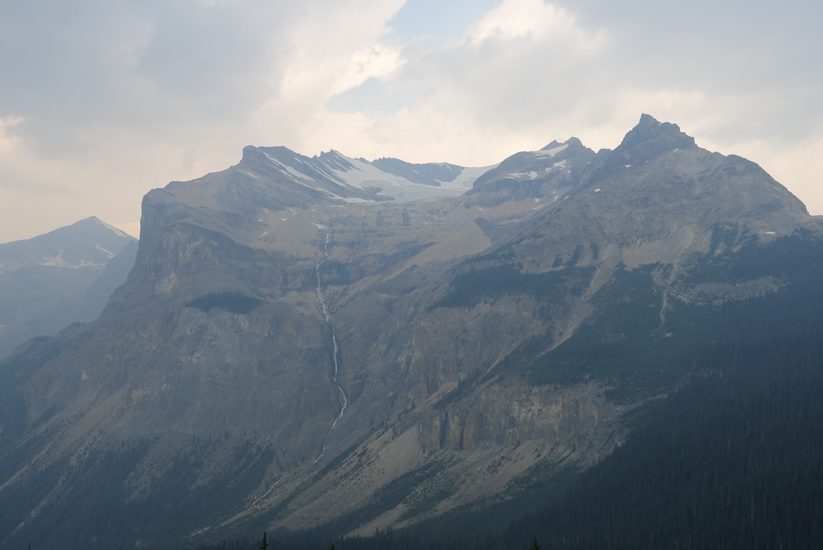
We climbed up 1556m in just over 22km, we camped at Little Yoho campground and enjoyed our time on the Iceline Trail rather than pushing up and over into the difficult section of the Alt. It was smoky and windy but a very nice day for hiking up through the Iceline Trail. Tanya and I hiked it a couple years ago so it was nice to revisit the trail with strong hiker legs!
We picked up our replacement tent in Lake Louise and it sure was nice climbing into it at the campground.
While it did weigh nearly 4 times as much as our previous tent, it was a fortress of comfort.
The next morning, we slept in and awoke at 6:30, ate breakfast and then went back to the tent. We didn’t end up leaving until 8:30. It was super cozy in the tent and after a zero in Lake Louise and a relatively mellow day it felt like we were traditional backpackers, rather than thru-hikers. It took a bit of effort to get moving. The rest of the day would be mostly off trail so we were savoring the comforts of camp while we could.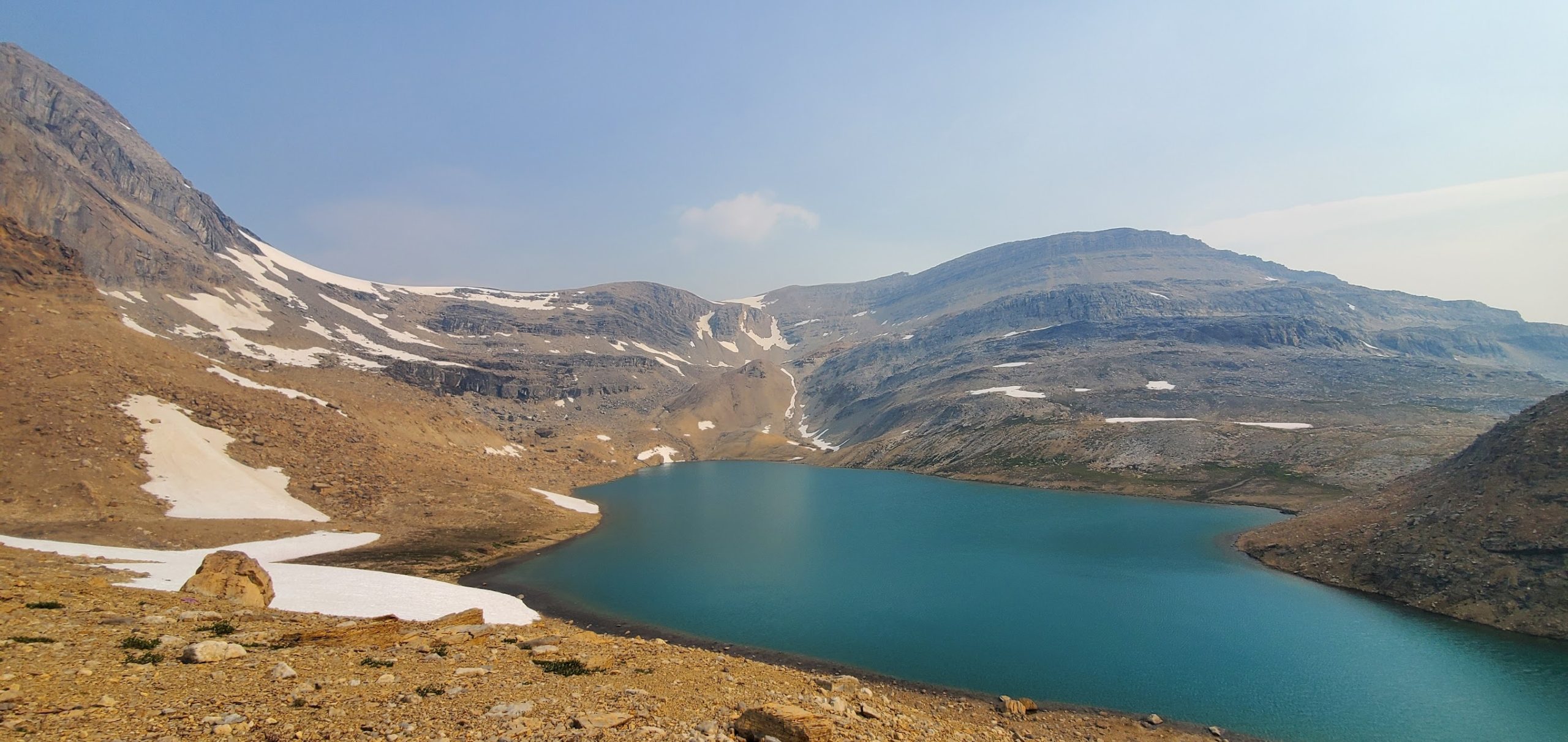
Once we were up and over the pass it was time to pick our route down to the valley. Looking down it was a boulder field. You could descend far right but enter into several no fall zones and more technical scrambling than we were willing to take on. Far left looked like a bit of a longer route but much more manageable. We took the center line, which probably could have been improved on a bit. It looked fun, some sections where you needed to stem the legs and use hands, and there were large boulders that needed to be climbed through.
My level of comfort in these sections is drastically different than Tanya’s and that should have been part of our decision-making process. As we slowly descended, we kept a short distance between the two of us just so we could communicate. At one point, my spidey-senses told me to turn around and I saw that Tanya had just fallen on the rocks.
She was on her back with her feet going uphill. 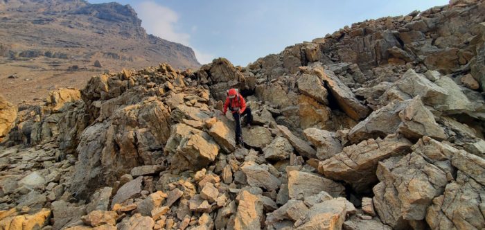

Thankfully a pack does a great job at protecting your neck and back. I quickly ran over to her and she seemed ok but was kind of shaken up. A fall like this could be really bad. It sounded like the rocks she stepped on, a little smaller than a soccer ball, had rolled out from under her in a pretty steep section. Besides a tear on her brand-new rain jacket, she looked relatively unscathed.
We took it very slow for the rest of the descent until we hit the valley. Really really slow. 8km took us 5 hours.
I was now getting a bit stressed for time. We still had to go up and over the next pass and then drop down through the final bushwhack to reach the old Amiskwi River Trail. Coming up the last pass, the Kiwetinok Gap, was crazy steep! We then descended through some steep alpine scree and into the forest.
Once we hit treeline, we were incredibly happy to see the route through the bushwhack was flagged. And by flagging, I mean flagged about every 30 or 40 feet. There was some evidence of other hikers coming through as a trail was slowly being broken in. Had the flagging not been here it would have tripled our time coming through this section
By this point I was getting grumpy.
Not grumpy at Tanya or grumpy that she fell but grumpy because it was turning out to be a very long day with not a lot of distance and I was stressed out. With time not on our side we just kept pushing through and never took our lunch break, which also doesn’t help with the grumpiness.
Once we finished the alt we arrived back on the Amiskwi River Trail and the official GDT. While our previous 30km involved over 2000m of gain, the official GDT would have been about 500m. This section of trail was an old road, however it was pretty overgrown. With some sections of willows and alders well over our heads, it really salted the wound whenever we would slowly start to get a good pace going. 
The stress and grumpiness were also aided by the fact that we were meeting someone on trail that evening. Dan Durston, the gear maker and GDT royalty was hiking in to do a bit of work on the trail. I had been chatting with him prior to the trail and was asking him about tents, as he has his own tent company, therefore has a lot of insight. I told him about our previous tent not working out and how we were switching to our other tent we had shipped out.
He asked us where we were going to be and the stars aligned, he would be hiking past us that night and would be bringing us a tent! Knowing he would be crossing our path I really did not want to make him wait.
After what was the hardest 20km section of the trail so far, we met up with him around 7pm. We chatted for a while in an insanely buggy meadow before we parted ways. His vehicle was down the trail a bit and we could stash our tent in his vehicle and grab it after trail.
He was an angel sent from the heavens bearing a tent for the rest of the trail.
On our app it showed there was a campsite less than 1km down the trail from where we met up. Unfortunately, there was no such campsite. It was a nice meadow but very lumpy and wet, nowhere in sight to set up a tent except back about 2km. We kept hiking. We finally came to the clearing and saw his vehicle at the end of a gravel road. First things first, we needed to eat. We cooked dinner and may have eaten in the back of his vehicle to hide from the bugs. We stashed our tent, set up the new tent, and crashed right away. It was a terrible campsite on gravel in a ditch on the side of an old logging road.
Day 27 and it was the first night on the entire GDT that we slept without neighbors!
The next morning, we woke up to soggy condensation on everything due to our terrible campsite. We got moving and flew down the first bit of trail as it was on a wide logging road. It was very nice to get the legs moving. We took a newer section of trail that is called the Collie Creek Alt but I firmly believe this should be the real trail.
Just after this we hit the official GDT halfway point! It was amazing progress and from here on out we would be chipping away at the second half.
We took lots of small breaks today and the hiking was pretty easy and flat. There were a handful of small river fords that people had talked about being scary but everything was at or below the knee. With very wet feet I walked without socks and insoles for a huge portion of the day. We hit the Howse River Floodplain and had super cool views looking out at the surrounding peaks as we traversed through the river valley.
Our day was going so well that we pushed to 32km quite easily, this meant our next day would only be 23km to the road and onto our next resupply! We camped right on the bank of the river after a nice day of hiking.
Our final day on Section D, only day 4, was mostly walking on the floodplain. Walking on a floodplain involves a lot of wet feet: constantly walking through water trying to figure out the best route to reach dry sections. At 7am this meant very, very cold feet.
We walked through the floodplain for about 15km. At one point we tried to follow our GPS track showing the actual trail, that turned out to be a mistake.
We eventually were knee-deep in a swamp.
Today was a low energy day. We walked with music through the floodplain and it was really nice. We were both falling in love with Section D, it was drastically different than the other sections and there was something very special about following the floodplain for such a long distance. It truly felt like we were traversing through the Rockies. It was also very relaxing walking for such a long stretch without a trail, knowing we couldn’t really mess up navigation, compared to other sections of route finding.
The trail eventually turned into the forest and we popped out at Mistaya Canyon, a slot canyon with a river powering through it. It was accessible from the highway and there were quite a few tourists checking it out, it was super cool.
Now it was time to hitchhike, neither Tanya nor I were looking forward to a 5km walk down the highway to our resupply. We thumbed it for a bit but it wasn’t looking good, so we talked really loud about how short of a ride we needed.
“I WISH PEOPLE KNEW WE ONLY NEEDED A RIDE FOR LIKE 4 MINUTES”, “IF PEOPLE KNEW WE JUST WALKED 600KM MAYBE THEY WOULD PICK US UP” and other things like that.
It worked! Someone who hiked a bit of the GDT a few years ago said he could drive us to Saskatchewan Crossing Resort.
To introduce Saskatchewan Crossing Resort, a bit of context is needed. It is on the Icefields Parkway, probably the prettiest road in North America. It travels through the Canadian Rockies and there are endless views of glaciers and peaks as you wind through the mountains for a few hours. Saskatchewan Crossing is a bit past halfway. There are no services on the entire highway, with the exception of here. It is a bit of an outpost; there is gas, a small store, places to stay but it does not have cell service and the internet is available through one desktop computer with Windows XP.
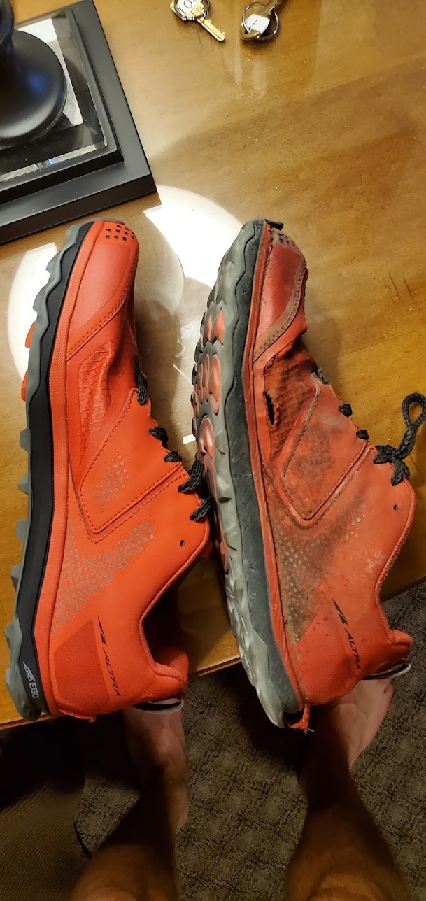
Our resupply box had a new pair of shoes for me and I was stoked. We grabbed our resupply box from the resort front desk and were told it would be a couple hours before we could check-in. Not a problem, we could hit the bar and chill. Until we found out the bar didn’t open until 5pm.
As we were walking out of the front desk building carrying our boxes someone asked us if we were GDT hikers, it was obvious that we were: small packs, running shoes, gaiters, very weathered and now carrying resupply boxes. He had just hiked a section but had to get off trail early. He left his car at the resort and invited us over to his car where he had a few beers. Oh, the magic of trail!
We sat at the corner of the parking lot and had some beers at his car and chatted about the trail for a couple hours.
We got into the room just before 5, showered and went to the bar for dinner.
What a strange place, $17 for a burger that you have to cook yourself… $17 gets you a defrosted Costco patty wrapped in plastic wrap, a bun and all the normal toppings.
Additionally, you can get salad and soup (obviously Campbells). Despite the crazy pricing and my $9 beer we didn’t really have a lot of other options.
We went down to the store to get some snacks and treats for our zero the next day. I have never had such a strong case of sticker shock in my life. Our 8oz fuel can, which can normally be found for $7, was $17. Our snacks for our zero included 2 packs of instant noodles @ $4.99 each, PopTarts @ $6.99, bags of candy @ $4.99 and $7.99, Nutella @ $8.99, a can of pop and a bottle of pop. The total was $47, in the real world it would have been under $20.
Accepting our fate, we pounded back the sugar and watched the Olympics and played a ton of ping pong. This was our best zero yet. Actually chilling all day, charging up everything, showering and eating without any obligation or needing to go anywhere. It was exactly what we were looking for

This website contains affiliate links, which means The Trek may receive a percentage of any product or service you purchase using the links in the articles or advertisements. The buyer pays the same price as they would otherwise, and your purchase helps to support The Trek's ongoing goal to serve you quality backpacking advice and information. Thanks for your support!
To learn more, please visit the About This Site page.
