Well, here I am in the middle of the North Island, and this hike has turned into a complete jumble. It all started with me, Rob, and Ellyse flip-flopping from our original northbound path to paddle the Whanganui River southbound and downstream. I suspect this disrupted something in the cosmic flow of our travels, because this is when the jumbling began. After the paddle we had to take a bus back up to the top of the river section to continue northward, and then there were some highway-walking bits that we wanted to skip, and THEN I had to get myself to Hamilton to buy a new pair of shoes, and then Ellyse hurt her back and went back to Australia, and later at one point Rob and I found ourselves mouldering in a garage in Te Kuiti… And now the whole thing feels like scrambled confusion. I’ve been rereading The Two Towers, in which Gandalf spends many hundreds of pages galloping back and forth across Middle-earth from Edoras to Fangorn to Helms Deep to Isengard to Minas Tirith, and I’m like, I KNOW HOW YOU FEEL BRO. So much simpler back in Book 1 when you were just hiking with the gang from Rivendell to Moria with a backpack on. SO! I’m going to attempt to recount some of the high points of the past week or so, and if you’re trying to follow along on a map you can just set it aside because the logistics here meant for a LOT of hopping around – so strap in and come along with me on this Te Araroa scavenger hunt, won’t you?
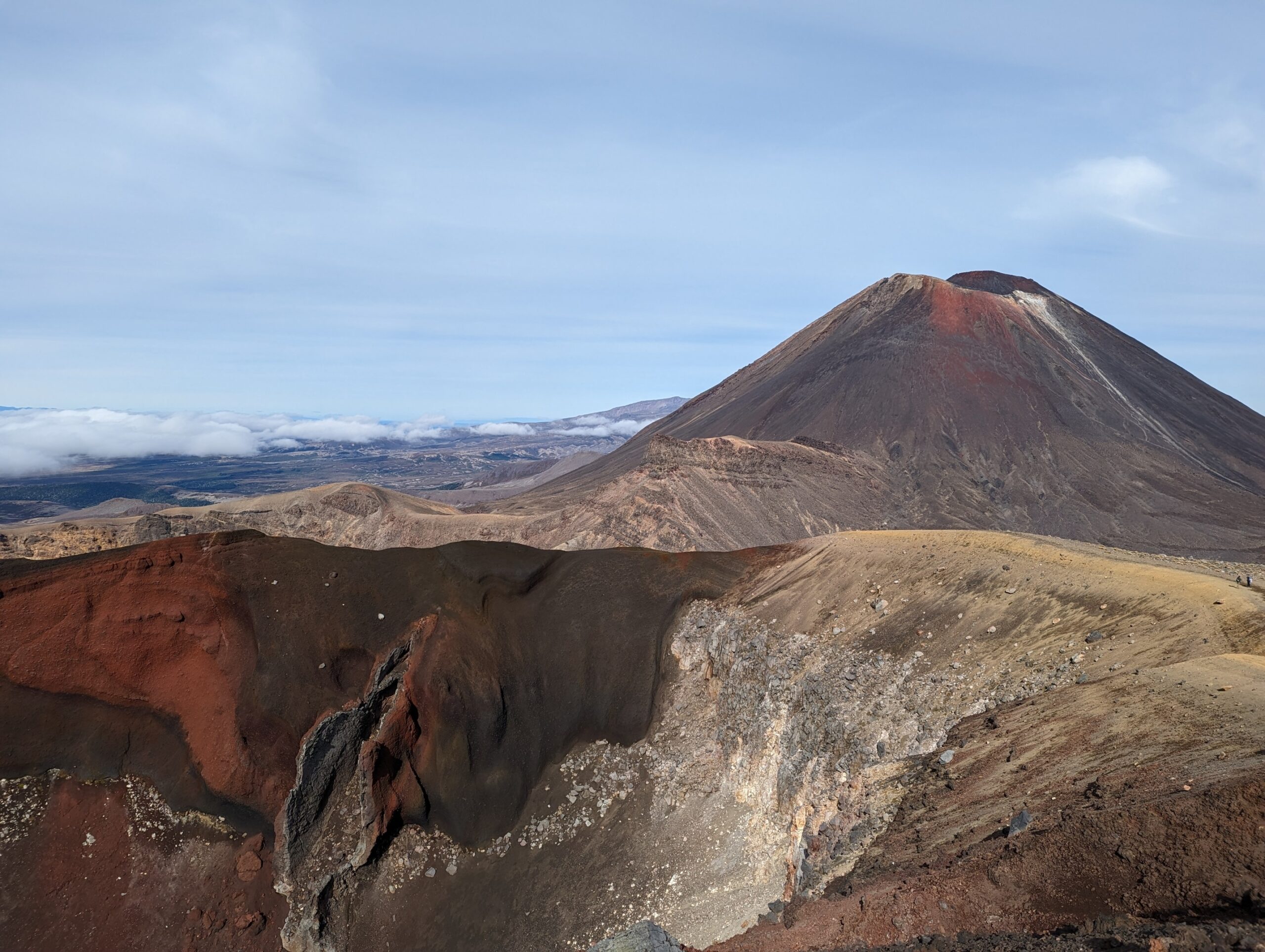
Our epic paddle down the Whanganui River was also the cause of Ellyse’s aforementioned back injury, and she wisely decided to rest up for a couple of days while Rob and I continued on to the next section of the trail, through Tongariro National Park. Here, the Te Araroa follows the Tongariro Alpine Crossing, which wends its way past Mounts Ruapehu and Ngauruhoe and then up and over Tongariro itself. These are all active volcanoes, and the terrain and views were incredible – unlike anything I’d ever seen before. For example: do you know what a fumarole is? (Geologists, don’t answer that one out loud while other people are still thinking about it.) Well, I learned that a fumarole is a volcanic vent at the Earth’s surface that emits infernal gases produced by the activity of subterranean demons. I SAW THESE THINGS! They were just sitting there puffing away like busy little devil smokestacks, fueled by the roiling red turmoil hidden below.
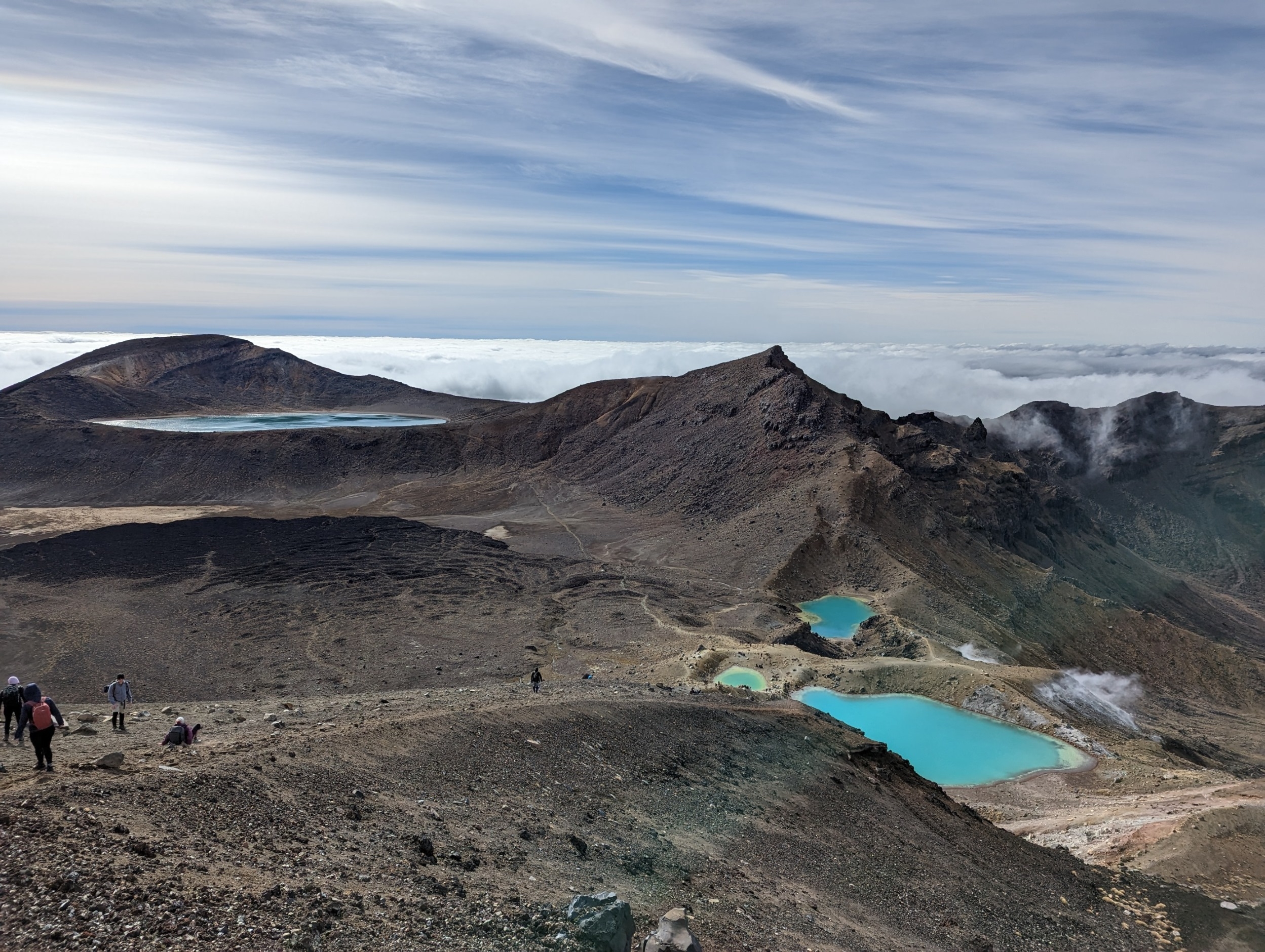
View of Blue Lake and Emerald Lakes on Tongariro. Those steamy-looking wisps to the right of the lakes are gases coming out of the fumaroles!
As a person who has had almost zero previous exposure to volcanoes, I’ve been completely bowled over by the reality of their existence. The last eruptions at Tongariro were in 2012, and although there’s ongoing monitoring there’s really no way to predict exactly when the next explosion might occur. There are lots of signs in the park reminding you of this fact, just in case you forget for a minute and mistakenly think you’re safe. One of these signs warns about “lava dikes,” which are apparently a volcanic phenomenon but which I really want to be the name of my biker gang.
Before climbing the volcano Rob and I spent a cold but beautiful night camping outside Mangatepopo Hut, where we saw one of the most incredible sunsets of my life. The slanting light cut eastward, casting the slopes of Ruapehu in an alien orange glow. To the west we could see all the way to lone Taranaki, arrayed with stripes and ranks of streaking clouds. We stood watching it for so long that I didn’t notice how cold it had gotten until after dusk – and then the ground froze solid overnight, lifting the loose volcanic sand around my tent into little crystal pinnacles that crunched when I trod on them the next morning, shaking crisp flakes of ice off my tent as we packed up.
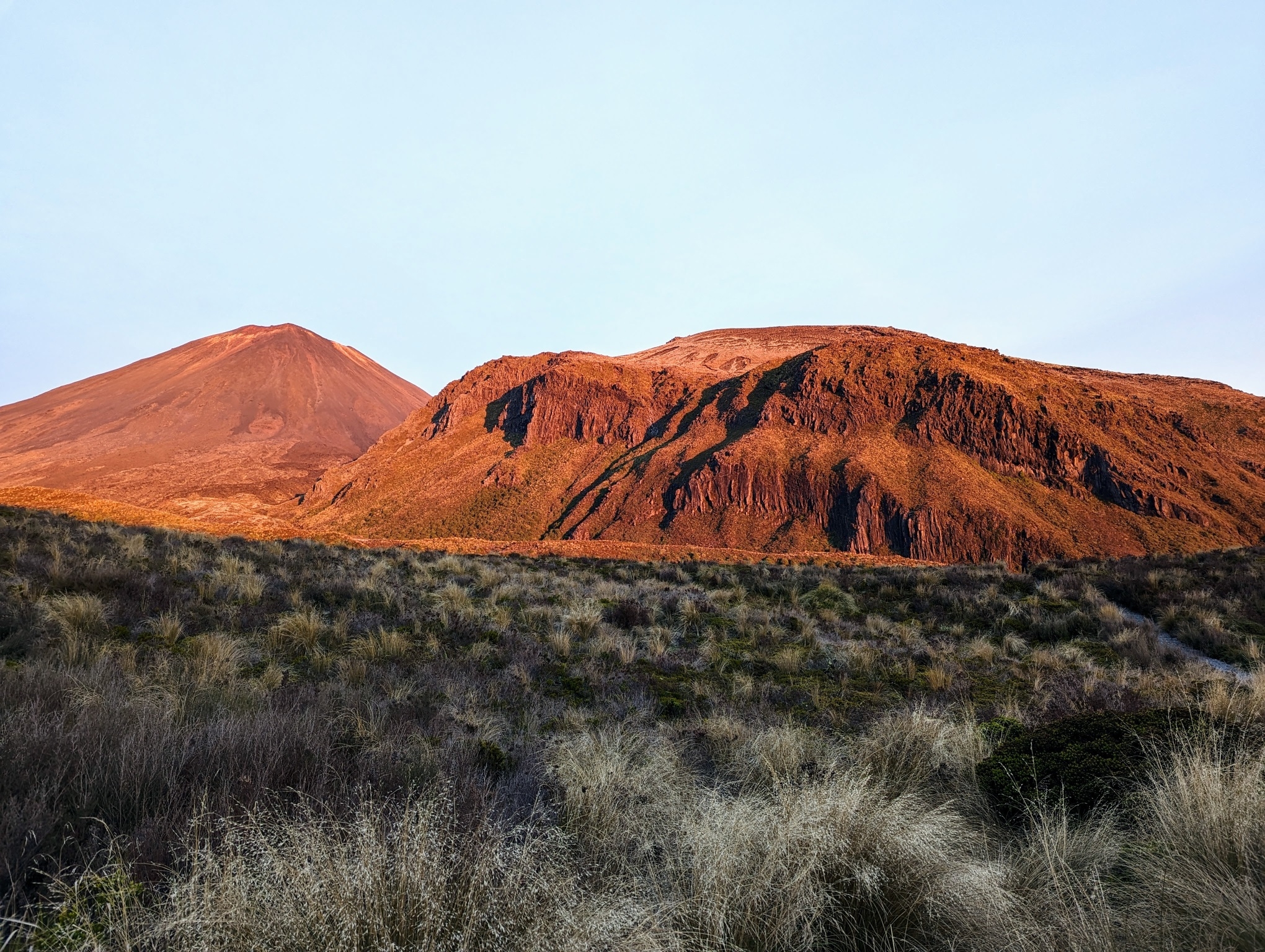
Sunset light on Ngauruhoe and Ruapehu
The Tongariro Crossing must be one of the most popular day hikes in New Zealand – we saw at least two hundred people over the course of the walk, and I’ve been told that the number of daily visitors can be easily three times that during the high season. But that doesn’t mean it’s easy by conventional standards: the climb involves an elevation gain of over 2450 feet and the end-to-end length is 12 miles – in other words, a pretty big day for the average person. Out of curiosity, I looked up some search-and-rescue figures and learned that in recent years the track has accounted for more hiking accidents than any other trail in the country – in the 2016-17 season, nearly 20% of all hiking-related S&R call-outs! (See the Mountain Safety Council’s
Tongariro Alpine Crossing page for more info.) I think this reflects one of the challenges of managing wilderness areas for public access, particularly when the allure of a place is tied to the very features (tricky terrain, remote location, dramatic weather, or active geology) that make it challenging or even potentially risky to visit. Nonetheless, the lady in front of us wearing yellow Crocs and a t-shirt seemed to be having a pretty good time, and Rob and I witnessed zero alpine rescues during our hike.
After the Tongariro Crossing, Rob and I met back up with Ellyse in the town of Taumarunui, where she’d been mulling over whether to continue walking or return home. With her back still sore, she decided it would be best to take a break and go home, so she booked a flight out of Auckland. Meanwhile, my feet had chewed through yet another pair of shoes, so I decided to accompany Rob and Ellyse on the bus as far as Hamilton, the closest city where I knew I could find a replacement pair of Altra Lone Peaks (re. the seemingly-bizarre devotion to these shoes: wearing shoes that don’t work for you is like wearing a pair of glasses in someone else’s prescription – you know they’re perfect for someone, but they’re definitely not helping you). Rob would go with Ellyse to the airport and then take the bus back to Hamilton, where he and I would meet up again and resume walking – but heading south, to fill in the section between there and Tongariro. If this doesn’t make sense to you, don’t worry – we were brewing up into Full Jumble Mode, and we ended up getting pretty confused ourselves – plus we ended up in Taumaranui about four times, which was plenty.
From Hamilton, Rob and I walked to Pirongia Forest Park, where the trail climbs up and over the extinct volcano for which the park is named. Unlike the newer edifices of Taranaki, Tongariro, Ngauruhoe, and Ruapehu, Pirongia is old enough that it doesn’t even look volcano-ey anymore (at least to my profoundly untrained eyeballs). Its last eruption is thought to have been about 1.6 million years ago, and since then erosion, weathering, and colonizing vegetation have colluded to chew the mountain down. From afar, it looks like a series of craggy ridges blanketed to their peaks in a deep and gentle green. But once you get on the trail – hoo, Nellie! – it’s a wild place indeed. Rob and I had the luck and honor to climb up and over Pirongia during what we later learned the Met Service (NZ’s national weather service) had designated a Severe Rainfall Event. I am pleased to confirm the accuracy of that determination. At the time, this was the most rain I could ever remember being caught out in. Four days later, that distinction was transferred to the NEXT Severe Rainfall Event Rob and I faffed around in – but more about that later. Suffice it to say that we swam down coursing waterfalls of mud, got soaked to the bone, and showed up at a trail angel’s house well after dark, not knowing that he’d actually gone out in his truck to look for us in fear that we were still thrashing around in the floodwaters somewhere. Ultimately all was well, and when the trail angel, John, told us we’d actually done twice as much distance as hikers usually do in one day through Pirongia, we allowed ourselves to bask in the warm and healing sunshine of his regard.
Next, we made our way to Waitomo, and just like that we were in another geological realm, the King Country Karst, which is actually quite a bit like the limestone region of central Pennsylvania, where I live. There are limestone bluffs and escarpments, hidden caves, underground waterways, and sinkholes – really cool stuff, which I’d love to come back sometime and explore. We stayed the night at a hut owned by a local caving club, the Hamilton Tomo Group, and since we had the place to ourselves (heavy rain = flooding = not a good time for spelunking expeditions) I spent some quality time looking through the club’s map collection. This was held in a massive old oaken flat file and included some incredible cave survey maps hand-drawn in the 1960s and ’70s by past club members.

Limestone outcropping on farmland in the karst country

Cave map at the Hamilton Tomo Group hut
By this time it had been raining for several days, and Rob and I were settling into what we’d concluded was going to be a New Normal of mildew and wet shoes. Accordingly, we mouldered our way along the trail to Te Kuiti, where we fetched up at the digs of another trail angel, Steve. Steve’s place proved difficult to find at first, as we naively assumed we were looking for a house. Once we broadened our waterlogged minds, we realized that we were actually bound for an old auto-body garage squatting between two gas stations, where we were to spend the night lounging with an adorable tabby cat named Mouse next to a red 1973 Mercury Cougar convertible. Steve’s daughter is a stock-car driver, and the garage had some pretty impressive photos of her as a teenager tearing up the tarmac. Also to my enduring delight, we watched stock car racing on the TV instead of King Charles III’s coronation, which was was going on at the same time. I now know more about stock car racing than I ever expected to – which I will confess is still very little, but somehow also more than enough.
After our garage interlude, we were ready to head down to Pureora Forest Park and the Timber Trail, a 51-mile section of the Te Araroa that follows the route of an old logging road and rail line. Many people opt to do the Timber Trail on mountain bikes, and since we had already paddled the Whanganui River in canoes we decided to rent bikes ourselves and complete the full TA triathlon. As it happened, our journey coincided with Severe Rainfall Event #2, as well as with a group trip by 25 kids from the Taurunga Boys College. “College” over here is what we would call high school in the US (“uni” being what we would call college), so these students were all about 16 or 17 years old. We’d all rented from the same cycle company, Camp Epic, and were planning on staying at their campsite halfway down the trail. Thus did I become the slowest and oldest person on the Taurunga Boys College cycle outing. Rob, who is 6’3″ and does Mixed Martial Arts for fun at home, mostly managed to evade the group while rocketing down the trail at terminal velocity. A couple of times I got ahead of the school group while they took a break and then pulled over to let them all pass me when they caught up. Rugby and football kids first (they were wearing team backpacks), then the main pack. Then a posse of about 4 kids at the rear, walking their bikes uphill. Science Olympiad and Poetry Club: You are my people. I see you and honor you. In fact, my legs are like noodles and my ass is bruised from the seat, and I’m gonna walk my bike up the rest of this hill too.

High banks along the Timber Trail
Re. the rain on this bike ride: did you know that if you don’t have fenders on your bike, the rain will fly off the front wheel and drive into your face in a vertical line, blinding you to the hazards ahead? True fact! This storm was, if possible, stronger than the one in which we’d hiked Pirongia, and the last 10 miles of the bike ride were a wild splashing downhill race of mud puddle mayhem, which was super fun and during which I caught myself cackling crazily as gravel was flung up into my face at 25 mph. When I arrived at the end of the trail I was covered in wet mud, and I took myself directly to the hose at the rear of the Camp Epic cargo container and, fully clothed, showered myself down in the cold rain. Then Rob and I spent the night in a shed at the edge of the parking lot while the rain beat mercilessly on the roof and the wind howled through the ragged-leaved poplars. The next morning, Paul, the owner of the bike hire company, offered us a ride into Taumarunui, where we could wait for our bus back up north.
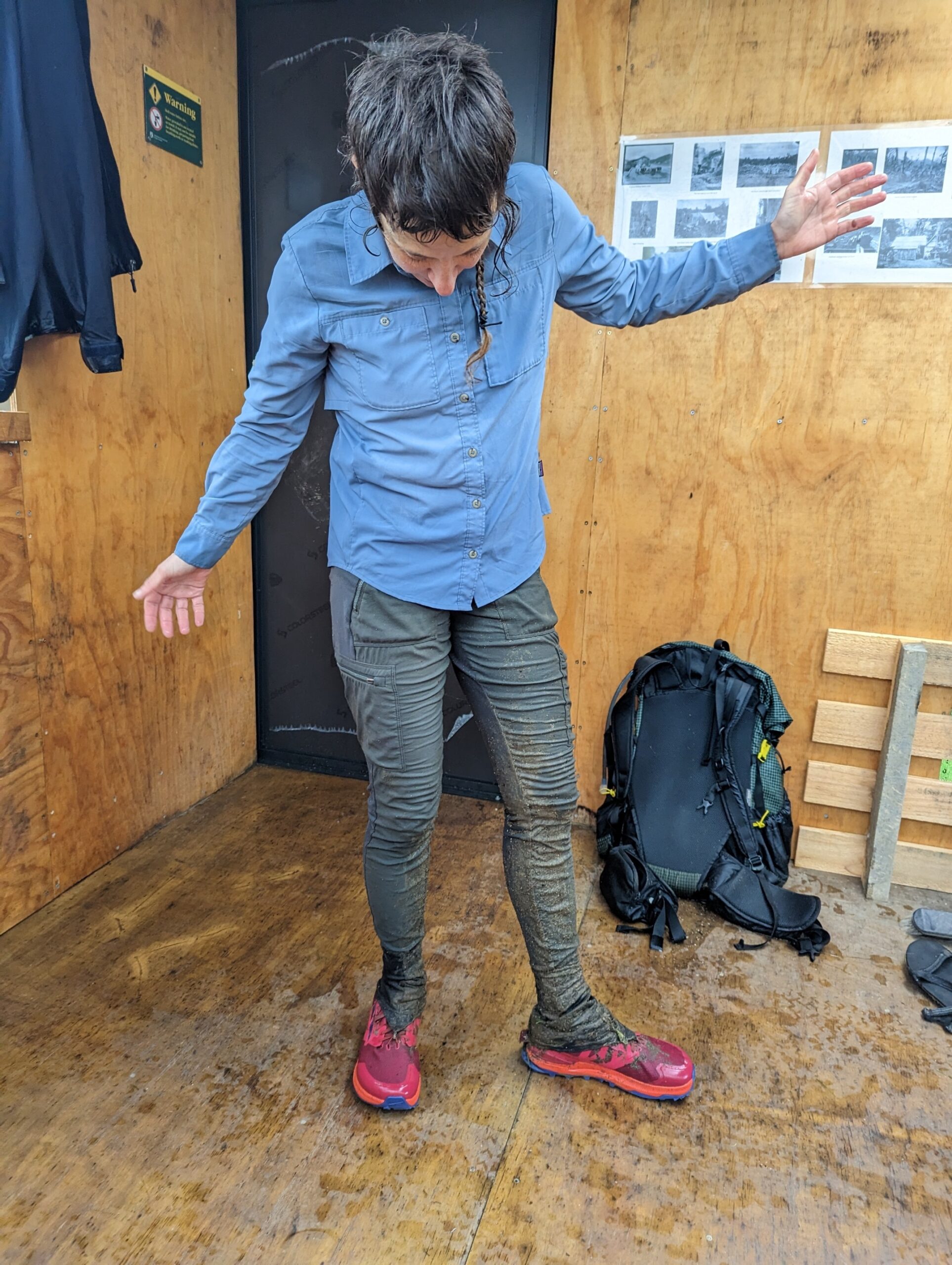
Soaked and hiding in a shed!
And as fate would have it, the Timber Trail ended up being Rob’s last Te Araroa mission for the time being. With Ellyse at home (but, thankfully, feeling better), the two of them decided it would be best for Rob to head back to Australia as well. They’re planning to come back at the beginning of June, but it looks like I’ll be hiking the final few hundred miles of the Te Araroa solo. If all goes as planned I’ll meet them, along with Ellyse’s dad, at the end of the trail on Cape Reinga. For now – onward to Auckland and northward through the rain!

T. rex sighting in Te Kuiti – barbed wire presumably to prevent escape
 ">
">


Comments 3
Did you love Hamilton? I remember it fondly from 1985 and 1987. I expect you saw it from a different perspective!
Outrageous adventures! I do know the part about a front tire without a fender in heavy rain. Not advisable…
Fumaroles sound like a delicious pastry–especially with Nutella! You’re getting close to the finish, right??? Can’t wait to see you back in geologically stable, Central Pennsylvania!
I <3 Tongariro with all of me. Volcanoes!
Also <3 to your muddy little braid.