 ">
">
The Border Route Trail: 65 Miles Deep in the Minnesota Northwoods
The Border Route Trail (BRT) is a 65-mile trail spanning the Boundary Waters Canoe Area Wilderness, an expanse of rolling hills, lakes, and forests that is a paradise for canoeists. The BRT is isolated, challenging, logistically difficult to get to, and it’s worth every step. It’s a short but very sweet trail that best serves the veteran hiker looking for a challenge that can be done in a matter of days.
The Border Route Trail At-a-Glance

- Length: 65 miles, point-to-point
- Expected Completion Time: 3-5 days; 15-20 miles per day
- Location: The Minnesota-Ontario border in Minnesota’s Arrowhead Region (Note: The eastern terminus of the BRT adjoins the northern terminus of Minnesota’s famed Superior Hiking Trail.)
- Best season to hike: Late spring (mid-May to mid-June) or late summer/early fall (September)
- Trail Type: Out and back, or shuttle
- Scenery: The area is heavily wooded with few signs of civilization. Hills and lakes dominate the landscape, and you’ll get daily views of Canada from along the trail.

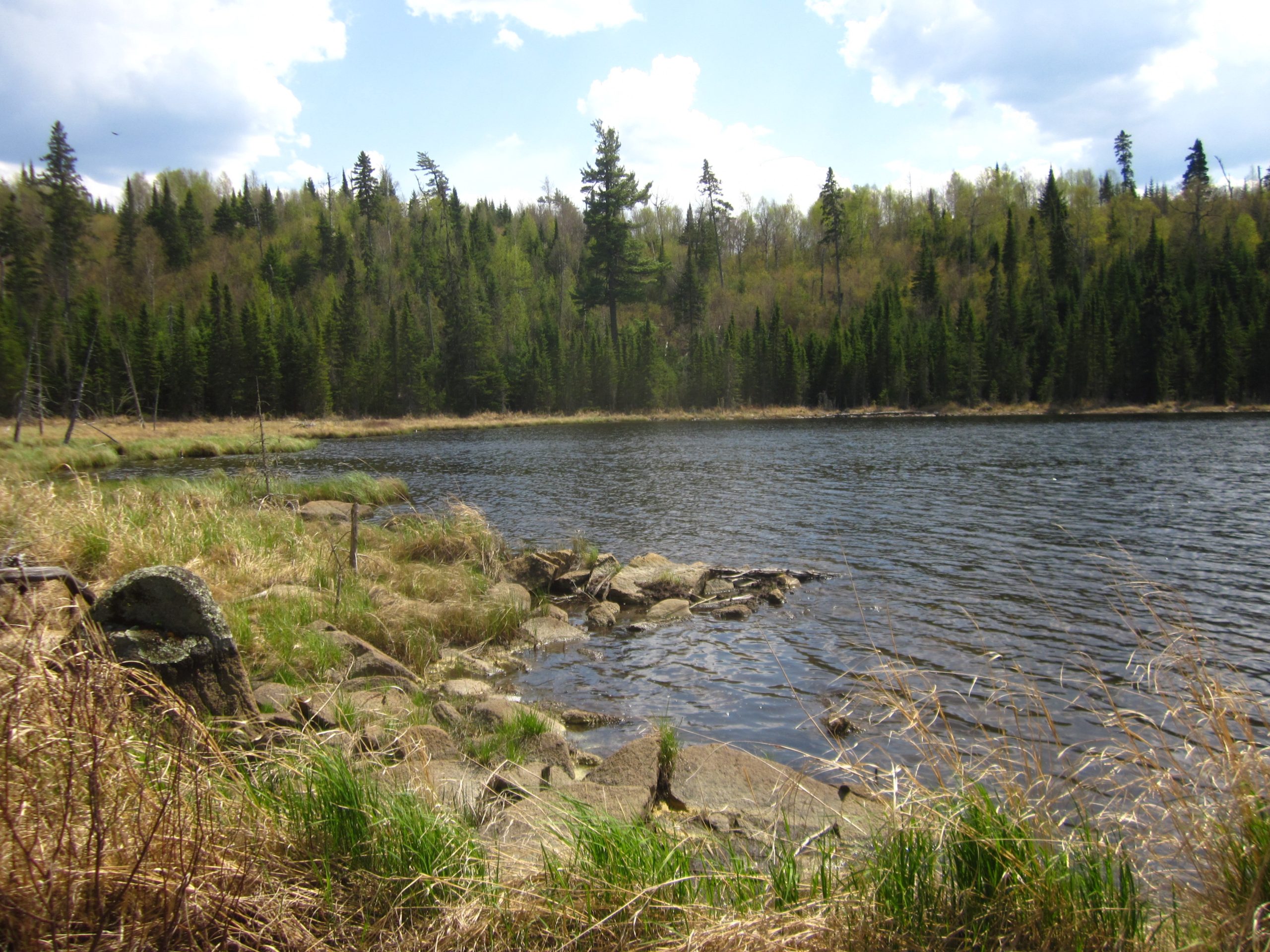
The Border Route Trail follows a chain of lakes that comprises the Boundary Waters, separating Canada (right) from Minnesota (left).
Terrain and Navigation
The terrain is moderate in difficulty. There are numerous hills along the BRT, none of which are very tall or steeply graded, but can be exhausting, especially in warm weather. The trail may be overgrown in places, especially early in the season before maintenance crews have had a chance to clear the brush. Fortunately, there are no rivers or creek to ford, nor are there any rocky stretches or very steep grades that may pose any immediate danger to hikers.
The BRT can be woefully undermarked in places, although with it becoming integrated into the North Country Trail, this may change. Regardless, make sure to have a map and know how to use a compass. The forest can be thick, making it impossible at times to orient yourself based only on your surroundings. For more information on maps, refer to the Border Route Trail Association’s website, where online and paper maps are available.
Getting There
The BRT is far-flung. It is not located on or near a major roadway, nor are there many towns nearby. The backcountry roads in Superior National Forest can be labyrinthine, and expect spotty cell reception to make navigation even more difficult. The easiest, surest way to get to either terminus is to hire a professional shuttle service who knows the area and let them lead the way. The Border Route Trail Association has a page of recommended local outfitters and transportation services here.
The BRT is a point-to-point hike, therefore either a shuttle service or two cars are required (unless you’re thinking of yo-yoing it.) For those attempting it using two cars, be warned you’ll have to take several winding country roads through the forest to get to the other end of the trail. Know where you’re going, and four-wheel drive is recommended as some of the roads may not be paved. Google directions here.
Direction
There is not any particular advantage in going east or west. Those going eastbound will pass through Grand Marais, MN when they are finished and besides being a picturesque lakeside town, there are several great restaurants and pubs as well as lodging and supplies to be found there. Those going westbound will have Gunflint Lodge very close to the end of the trail.

Why Hike This Trail
The BRT is remote. No matter which direction you go, you’re deep in the wilderness when you first set foot on the trail, and you’re deep in it when you finish. It offers the kind of isolation many backpackers look for.
However, this should also be regarded as a marker of difficulty, as getting injured or sick on the trail runs a higher risk than many other trails. Although there are exits in the form of trailheads throughout and likely other hikers and canoeists in the area, getting off the trail might not be easy. (Tip: If you’re using a shuttle service, have their number handy and work out an arrangement in advance to get picked up at a trailhead in the event of an emergency.)
The BRT is also physically challenging and can be difficult to navigate. This is a great, short trail to build confidence in backpacking for those who have taken the first steps but haven’t quite worked up to a long trail. It’s also a fun challenge for experienced backpackers who want to get away for a long weekend. Your reward other than isolation and challenge will be countless vistas of wooded, rolling hills, and glimmering lakes. You’ll probably get more than your fair share of wildlife sightings, too.
Finally, you’ll encounter lakes throughout most of the trail. This not only means that water sources are frequent, but you’ll get the added bonus of swimming and fishing if you so desire.
READ NEXT – 6 Reasons to Visit the Boundary Waters Canoe Area Wilderness
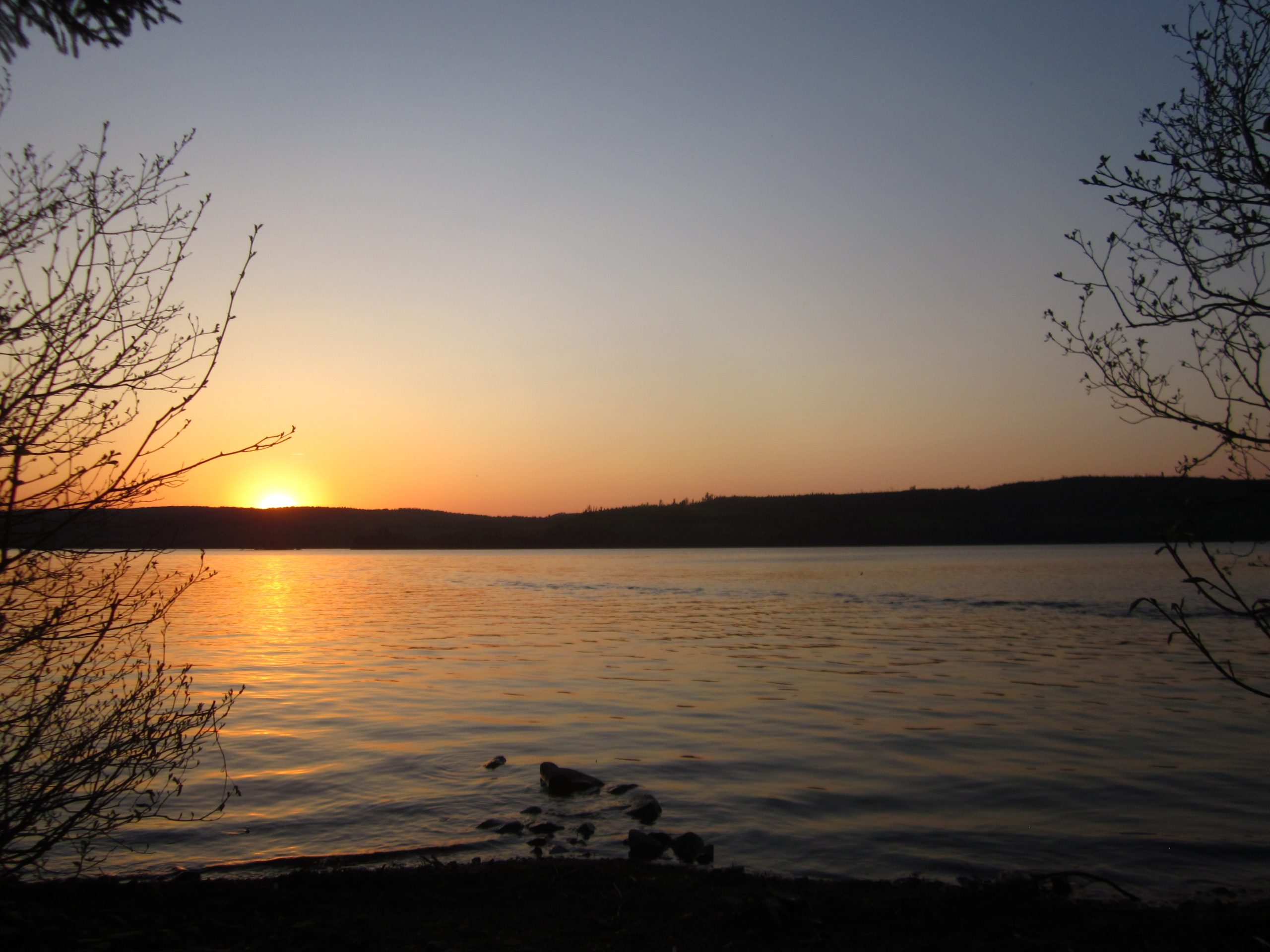
Watching a sunset on a lake in northern Minnesota is one of those experiences everyone should have at least once in life.
Climate and Weather
Upper Minnesota has a warm-summer humid continental climate. This means hot, humid summers and cold, snowy winters. As with much of the Upper Midwest, hiking the BRT is best done in the shoulder seasons, particularly late spring and early fall.
The BRT is totally hikeable in the summer, although the errant backpacker will have to contend with swarms of pests, namely mosquitoes, horseflies, deer flies and ticks. Furthermore, weather can be very humid in the summer, and thunderstorms from the west come quickly to Minnesota: a bright, sunny afternoon can quickly transform into a thunderstorm and a downpour.
Late spring, specifically late May to mid-June, is a great time of year to hike, although the weather can still be quite mercurial. When my group had hiked over Memorial Day weekend, the weekend prior had seen several inches of snowfall and the weekend we hiked was hot and we had encountered the first bloom of wood ticks for the season, which we got to pick off us for the next several days.
Early fall, specifically most of September, is also a great time of year to hike the BRT. Most of the bugs will be gone for the season and days will be milder and nights cooler. By mid-September, this area will likely have seen its first frost already, and snowfall isn’t out of the ordinary for this time of year.
Regardless of when you choose to hike the BRT, be prepared for wet weather that could last for the entire hike.

It can get rainy, foggy, misty, or all of the above.
Gear Suggestions
Be sure to have rain protection, as storms can come on suddenly and rainfall can last for days. Dress appropriately for the season, and be fully prepared for hot days even in spring or fall, and very cool days even in the summer. Bring sunscreen and bug repellent, and make sure your first aid kit includes ointment to treat and relieve bug bites.
Shoes or boots with good ankle support and trekking poles aren’t necessary, although they are always worth considering on any hike. You won’t have any steep climbs or descents, nor should there be any significant water crossings (unless a beaver has recently decided to terraform some of the forest and in doing so, flooded the trail.)
Also, bring a physical map and compass, and know how to use your compass. There are other trail junctions throughout, most of which are portage trails and will eventually dead-end you at a lakeshore, but even a short wrong turn can sap valuable time and energy.

Minnesota on the left, Ontario on the right.
Camping
A permit is required for all overnight trips, and regulations can be found here. Permits can be purchased here, or at the ranger station in Grand Marais.
Hikers can camp anywhere along the trail provided it is at least 150 feet from the trail or a body of water. When possible, it is advised to stay at campsites. Fortunately, this shouldn’t be a problem as there are many developed campsites along the BRT, and the Border Route Trail Association has an excellent page describing each site here. Furthermore, their map shows the location of each site, which will allow you to thoroughly plan your itinerary.
Be aware that campsites are first-come-first-serve, and the BRT cuts right through the heart of the Boundary Waters Canoe Area. This means you’ll be competing with canoeists over spots, especially for those pristine lakefront campsites. However, many sites are large enough to accommodate more than one group, so you may not necessarily be out of luck if someone is occupying your desired site. If a site is full or you are hesitant to camp with a group of strangers, there are many more sites, especially on the western half, and the next one may not be too far.

Dramatic cliffs topped with pines towering over the Boundary Waters that separate Canada and the United States.
Highlights
Deep wilderness. Rolling, forested hills. Blue lakes shimmering in the distance. You’ll get vistas of the undulating landscape and sparkling lakes throughout the hike, but you’ll also get plenty of opportunities to go for a swim, whether it’s cooling off during a midday break, or at camp relaxing and having fun with your friends.

The glassy waters of an idyllic lake deep in Minnesota’s Northwoods.
Water Sources
You shouldn’t have to carry too much for too long at any given time. Lakes are frequent along the BRT as well as the occasional creek or small river.

One of many vistas of the countless lakes along the Border Route Trail, with the forested hills of Ontario skirting the horizon.
Resupply Options
Not long enough to require a resupply.
Closing Thoughts
The experience of hiking the BRT is one of isolation, of being far away from civilization. It’s a challenge in more ways than one: it’s far away, it’s wild, it requires navigational skills and it’s uncompromising. Yet all those challenges are what make it particularly rewarding, and its length is perfect for an experienced hiker looking for a challenge without committing weeks of his or her time.
The Border Route Trail is the quintessential Northwoods adventure, and you’ll get some of the best that Minnesota and the Upper Midwest have to offer.
Featured image: Graphic design by Jillian Verner (@yourstrulyjillian).

This website contains affiliate links, which means The Trek may receive a percentage of any product or service you purchase using the links in the articles or advertisements. The buyer pays the same price as they would otherwise, and your purchase helps to support The Trek's ongoing goal to serve you quality backpacking advice and information. Thanks for your support!
To learn more, please visit the About This Site page.

Comments 9
Well written article Matt.
My family’s from New Ulm…you’ve made me thirsty for a Schells
Have you hiked this trail? I have, and dude there were blow downs for 100 yard stretches at a time, often. Talk about a challenge constantly climbing over and crawling under mature timber trunks with a 40-50 lb packs! Multiple times on the first day one of us held the last know place on the trail while the other 5 in our group bushwhacked up ahead to find the trail again. We camped the first night at our planned lunch spot because we would have never made it to our planned sleep spot in the light. The 2nd day the trail literally went straight through part of a lake thanks to beavers building a dam below the trail (how often do these “maintenance crews” come through?!) And when we realized we were less than halfway to our exit on the 2nd night because of how slow going this Tough Lumber (as opposed to Tough Mudder) challenge was, we had to climb to the highest point we could find and use Canadian cell service to call an outfitter and have them send us a boat to the nearest portage the next day. The only time we saw chainsaw cuts clearing blow downs off the trail is when the BRT temporarily merged with a portage between two lakes. Good to hear another bigger trail is merging with it so the BRT might actually become established by human feet again and the blow downs cleared, but when we hiked it in July a few years ago you might as well call it impassable. Got home to find articles about other people getting lost on the BRT and calling 911 (not realizing the got Canada’s 911) for a rescue. Would recommend the BRT 5/5 stars.
I hiked part of this some years back. Numerous tree falls made for very slow going.
It is very remote and wasn’t getting much maintenance at that time.
I would have never thought of adding this to my list of must-see destinations. Thanks for sharing!