 ">
">
The Colorado Trail Guide: Section by Section
If you want to get a sense of what the Colorado Trail is actually like, this guide will tell you the basics for each section of the CT. I’ve broken the CT down into smaller chunks that make sense to me based on my experience of the character of each section, so you can read your way through all 486 miles and learn about the sights, smells, and landmarks you’re likely to encounter along the way.
Take everything I’m about to tell you with a big old grain of salt because the conditions of the day will dramatically affect your experience of the Colorado Trail: the same stretch of trail could look and feel completely different to two hikers on different days.
Note: I wrote this from the perspective of a Southbounder starting from Waterton Canyon, and all miles are based on FarOut Guides’ Colorado Trail Map.
READ NEXT – Everything You Need to Know to Hike the Colorado Trail
Quick Navigation
Segments 1-3
Segments 4-5
Segment 6
Segments 7-8
Segments 9-11
Segments 11-14
Segments 15-19
Segments 20-21
Segments 22-23
Segment 24
Segments 25-28
Mile 0 – 40.7 (Segments 1 – 3)
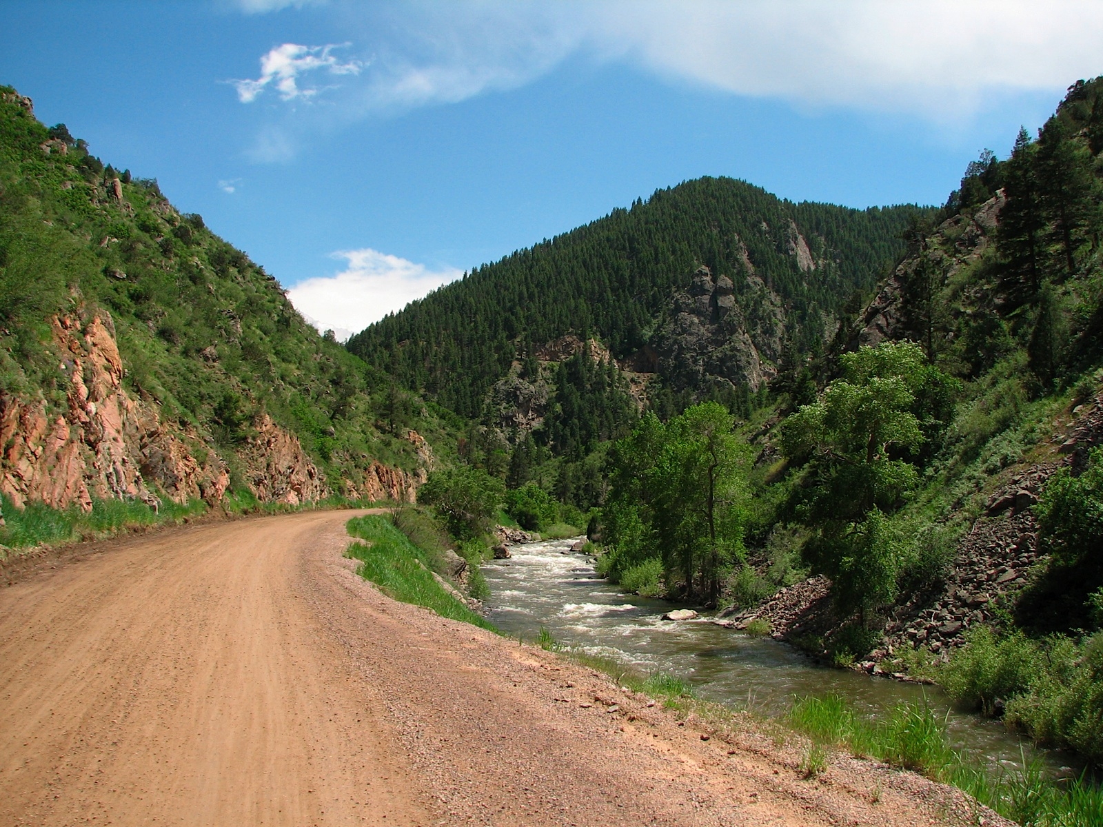
Follow this gently-graded road all the way to the top of Waterton Canyon, and keep your eyes peeled for bighorn sheep along the way. Photo via.
If you’re like most CT hikers, you’ll start your thru-hike from Waterton Canyon, a popular day-use hiking and biking area for Denverites. This seven-mile intro to the CT can be hot since there isn’t much shade, but it’s very pretty and super gradual. Keep an eye out for bighorn sheep in the canyon. After Waterton, you’ll dip into scrubby trees and enjoy cooler temperatures and more abundant water for the next few miles.
Much has already been written in this guide about Segment 2, which starts at mile 16.5 at the South Platte River. So I’ll just summarize here: 10 miles, very hot, very dry. Start early in the morning and pack plenty of water. It’s a gorgeous, desertlike stretch if you’re prepared to handle the heat.
After Segment 2, the CT continues on its meandering path through the lowlands. It should be noted that the trail hasn’t broken above 8,000 feet so far, so if you’re hiking in the summertime like most people, conditions will likely be pretty toasty. You won’t go so long again without water as you did in Segment 2, but the environment will continue to be arid and shrubby with sparse shade from tall shrubs and evergreens.
Mile 40.7 – 71.4 (Segments 4 and 5)
Just a few miles into Segment 4, you’ll enter the Lost Creek Wilderness Area, where you’ll have to stop at the kiosk and fill out the free permit. The trail is mostly forested in this section. Mountain bikes are not allowed in this or any other Wilderness area. The trail climbs a lot in Seg 4, so show up ready to work.
In exchange, you’ll get above 10,000 feet for the first time and the trail will start to feel cooler, lusher, and more mountainous. Incidentally, at mile 45.2 you’ll cross a gorgeous rocky stream, and there will be ample camping just before the crossing if you look downslope. This is a great stop to break up your first big climb of the CT into more manageable chunks.
After the high point at 47.5 and descending for about a mile, you’ll start a very long, gradual, beautiful five-mile climb through a long valley that’s fairly open and features many expansive views. The trail is mostly exposed, so this may be a section to tackle early in the day if possible.
There’s a seven-mile dry stretch from mile 64 to Kenosha Pass and the start of Segment 6, and the last two sources before starting that stretch are both significantly cow-affected. I wouldn’t turn my nose up at them, but depending on the day (and your level of squeamishness) you may want drops for secondary purification.
Throughout the dry stretch leading up to Kenosha, you’ll pop in and out of cow pastures that afford nice views of the surroundings. These meadow walks are broken up by short stretches through aspen groves. Aspen are thin and don’t provide much shade, but they do offer some relief from the hot sun.
Mile 71.4-100.3 (Segment 6)

A busy highway goes through Kenosha Pass, and there’s a campground there where you can fill up your water. Some hikers hitch into the towns of Jefferson or Fairplay from here.
Shortly after the campground, you cross Jefferson Creek around mile 75. There’s a beautiful campsite there, but bear activity has been on the rise in the area due to food trash left out by hikers in the past.
Then you start the long climb up to the beautiful Georgia Pass. You’re likely to encounter quite a few mountain bikes in this stretch. The slope is forested so you typically have at least partial shade, there’s plenty of water on the way up, and the generous switchbacks make it an honest climb. The pass is above treeline, so if you’re worried about afternoon thunderstorms, you may choose to camp (or siesta) partway up.
Georgia Pass was really the first time I felt like I was hiking in the Rocky Mountains on this trail. The views are to die for up top, and the surrounding peaks are indeed starting to look bigger and wilder. Depending on the season and the year, many of them may still be graced with snowy caps.
Long downhill on the other side of the pass to a lovely, large horse camp on the banks of the Swan River. The campsite is adjacent to a dirt road and you may encounter car campers on summer weekends: consider yourself warned.
Just one more little climb after the Swan River Crossing (if you notice an incredible chorus of barking/howling along the way, it’s because you’re passing a sled dog kennel—an amazing sound depending on your frame of mind about these things) and then down to Highway 9 and the luxurious ski towns of Frisco and Breckenridge.
Mile 100.3 – 143 (Segments 7 and 8)
The first few miles of the climb out of Breck are hot and dry thanks to a wildfire that incinerated much of the slope. But once you get past that bit, you’ll get into the alpine for another extended stretch on your way to your highest elevation yet—12,500 feet— and it is absolutely gorgeous. Shortly after you first break out of the trees (warning: the section right around treeline is particularly steep and exhausting), you’ll have an incredible view of Tenmile Peak (Peak 1). From the top of the climb, you can see down to Copper Mountain Ski Resort on the other side. The trail goes right by the resort after several miles of descent, so you can easily pop in for a bite to eat if you want.
Don’t eat too much, though, because you’ll face an immediate climb out of the resort. You’ll have prime wildflower-viewing opportunities as you make your way up a tough climb to Elk Ridge and Kokomo Pass and then down the other side to Camp Hale, a WWII-era Army training camp that is now retired. You’ll walk right past the old bunkers, and there are still signs in the area warning hikers to stick to the trail because of possible unexploded ordinance in the area.
Following a seven-mile, very gradual climb from Camp Hale (including several miles of smooth, gently-graded walking on a retired dirt forest road), you’ll reach Tennessee Pass and the end of Segment Eight. You can hitch into the charming town of Leadville pretty easily from here.
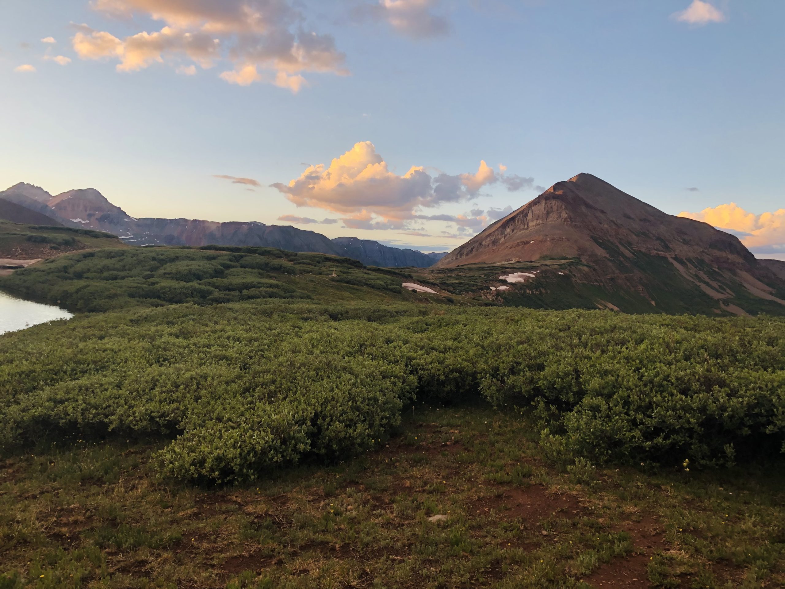
Mile 143 – 177 (Segments 9 – 11)

Camped among the aspen near the base of the Mount Elbert approach trail.
Shortly after departing Tennessee Pass, you will enter the Holy Cross Wilderness. A series of sharp climbs will get you up and over the ridge, going past several lovely alpine lakes along the way. The trail continues to bounce around through forested landscapes mostly between 10- and 11,000 feet.
At miles 166 and 170, you will pass junctions with the Mount Massive Trailhead, your first opportunity to summit a 14er, followed closely by the Mount Elbert Trail junctions at miles 170 and 175. (Mount Elbert is the highest summit in Colorado and second-highest in the Lower 48 after California’s Mount Whitney). The forest becomes very aspen-dominant around Elbert, meaning shade will be on the sparse side.
At mile 175 you can take a shortcut side trail down to Twin Lakes Village, or you can continue on the CT and do a short road walk into “town” (which really just means the general store, there’s not much around) if you need to resupply.
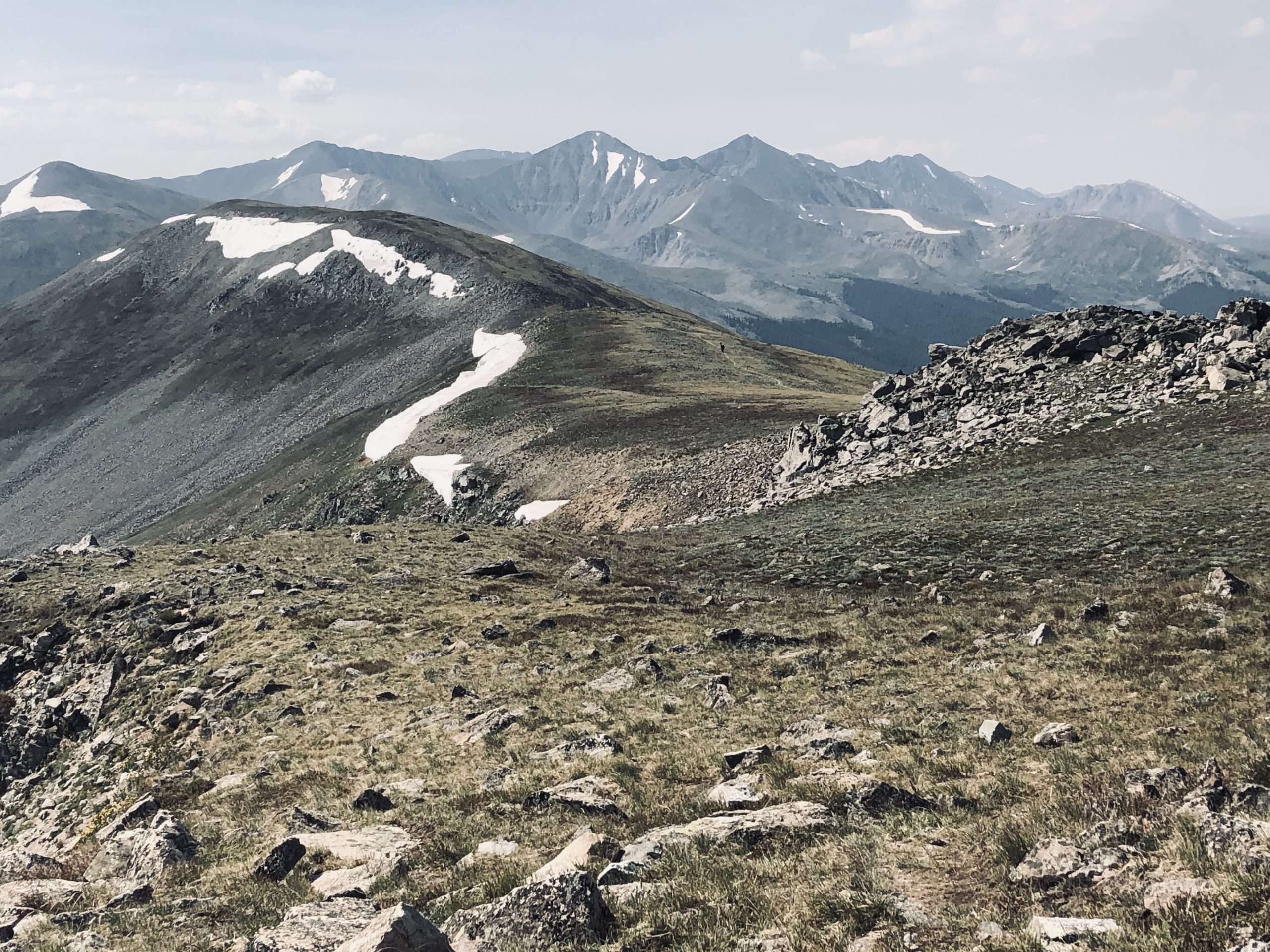
Miles 177 – 253 (Segments 11 – 14)
Um… Photo via.
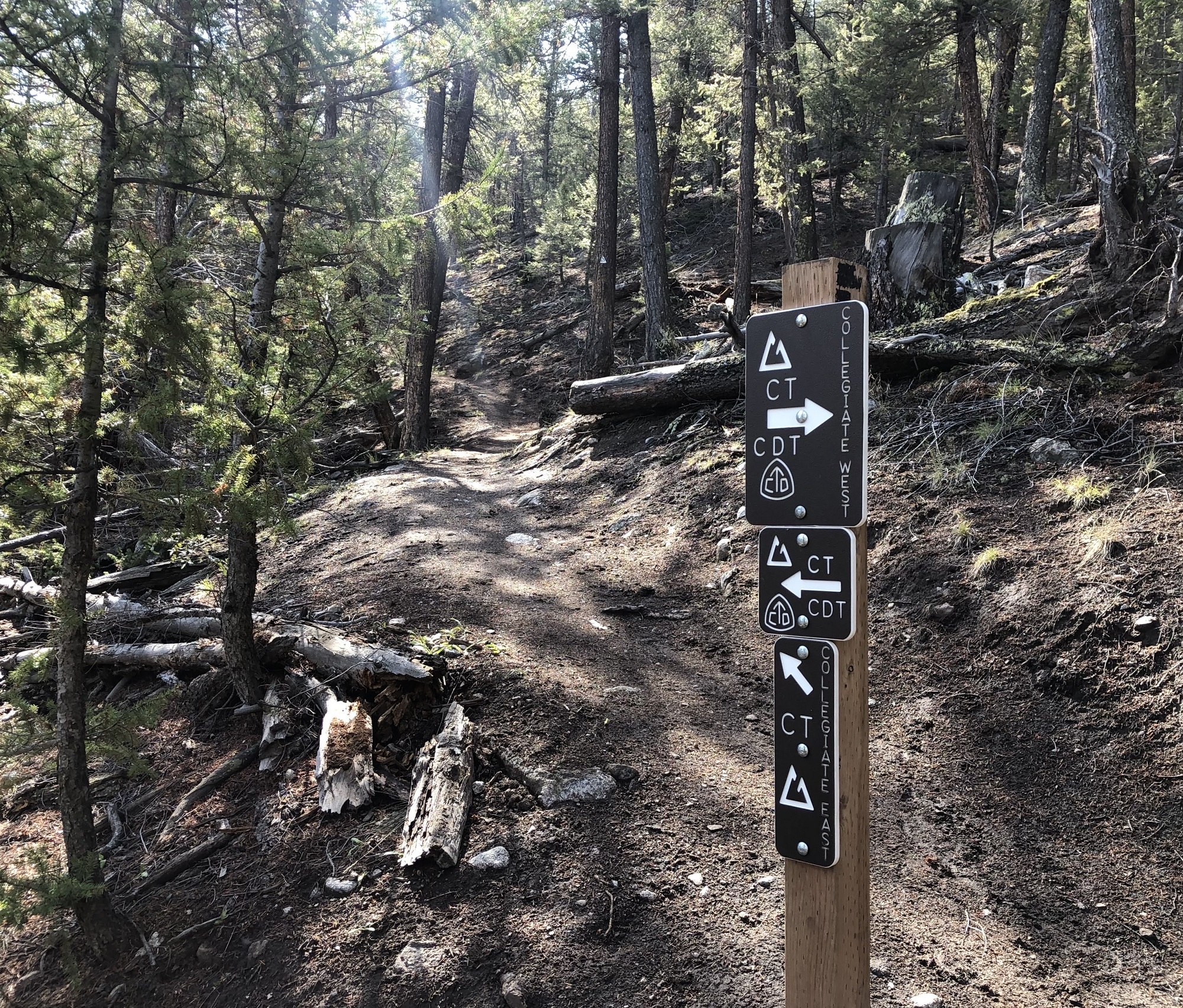
After Twin Lakes, you have to decide whether to hike Collegiate East or the Collegiate West Alternate. Although Collegiate East is the official route of the CT, both paths are accepted by the Colorado Trail Foundation as part of a CT thru-hike. Collegiate West is more grueling but also more scenic, while Collegiate East doesn’t have quite as much elevation change and keeps to lower elevations more of the time, so you’re less at risk during thunderstorms.
To get a sense of what this section will be like and which of the two routes you should choose, check out Collegiate East vs. West: 8 Key Differences for CT Hikers.
Either way, you’ll pop out of the Collegiates at Highway 50 some 75 miles later and most likely hitch down to Poncha Springs or Salida to resupply.
Miles 253 – 330 (Segments 15 – 19)
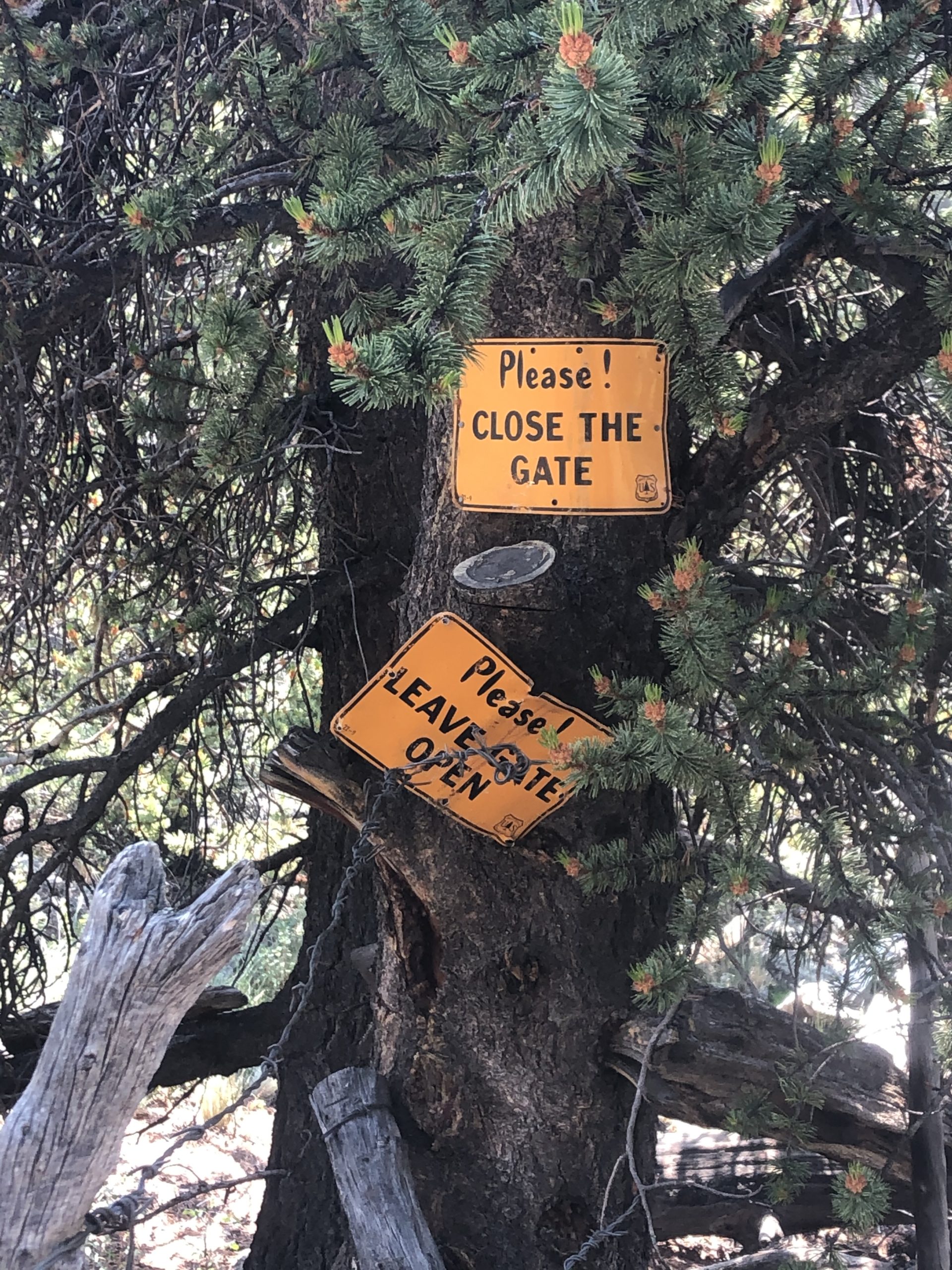
Favorite sign sighting on the whole CT. Spotted just before Eddiesville Trailhead and the end of Seg 19.
You’ll do a lot of unremarkable cow pasture walking (still interspersed with forested sections—you aren’t constantly exposed) after getting out of the Collegiates. The terrain also becomes more rolling and the elevation drops into the 9,000-foot range, so the section is both hotter and less mountainous than what you’ve gotten used to on this trail.
This stretch is still pleasant in its own way, though. The steady climb up to Sargent’s Mesa is a section highlight, offering a more pastoral vibe than the CT normally serves up.
Segment 19 is a nice way to wrap up this little interlude. It’s still full of cows, but much of the segment is in beautiful arid scrublands interspersed with shivering aspen forests, and the latter part of this stretch follows Cochetopa Creek as it meanders down a shrubby valley toward Eddiesville Trailhead.
Miles 330 – 358 (Segments 20 and 21)

The trail gradually shifts in character as you make your way toward San Luis Pass from Eddiesville Trailhead. The shrubby cow pastures slowly give way to tall, jutting peaks on either side and a marshy, willowy valley floor. You’ll climb up to a saddle with an unmarked mile-long trail up to the top of San Luis Peak and then continue on a steady downhill to San Luis Pass on the other side, from where you can access Creede.
After miles of fairly monotonous pasture walking, you’re launched back into sensory overload in Segments 20 and 21. Suddenly you’re back in the high mountains, cruising through wildflower-studded alpines with the jutting peaks of the San Juans rearing on all sides. Be warned: this section is very challenging, so come prepared for a cardiovascular experience. You’ll wrap it up with a long, exposed traverse of Snow Mesa before dropping back down to asphalt at Spring Creek Pass, the access point for Lake City (or, less commonly, Creede).
Miles 358 – 391 (Segments 22 – 23)

Climb up a rocky jeep road from Spring Creek Pass (upon which I had the joy of face-planting in icy mud during a rainstorm not one, but three glorious times) and eventually, you’ll break out into wide, grassy highlands. The terrain slopes away so gently on either side that you feel like you’re hiking in mildly hilly flatlands, rather than in the heart of the Rockies and approaching the Colorado Trail’s 13,259-foot high point at mile 373. A technicolor array of big peaks and crags off in the not-too-far distance clues you in that you’re still in the mountains.
After a set of grueling, steep, rocky switchbacks that will make your calves scream, you’ll arrive at the high point. It is slightly anticlimactic—just more grass gently sloping away in every direction and a wooden sign to mark the significance of this place. Still, if you’re like me and manage to go across the high point on a summer afternoon, with impending thunderheads of doom nipping at your heels, it will be dramatic enough regardless.
Shortly after the high point, you’ll join a dusty jeep road (watch out for ATVs), pass an interesting sinkhole, and then start contouring one side of a long valley. Several miles later, you will enter some of the most singular, glorious hiking of the entire Colorado Trail. I’m not a big spender, but I found myself longing for a $400 GoPro all throughout this stretch. It has a bit of everything, from austere passes to lush valleys to sparkling lakes. A friend of mine reported seeing a moose submerged almost to his antlers in a lake in this section while he grazed the lake bottom.
You’ll end the section with a hot, dusty road walk on Stony Pass Road, where, if it’s a weekend, you might get to “enjoy” the “pleasure” of being passed a conga line of jeeps and ATVs on their way up to the scenic summit.
Miles 391 – 412 (Segment 24)

Elk Creek Canyon viewed from mile 398.
The trail splits off from the road before the top of Stony Pass Road (the juncture marks the beginning of Segment 24) and starts another long, gradual descent through grassy meadows. You’ll bounce around in these curious hills for some miles. There were lots of sheep grazing in this area when I went through, but the herds move around quite a bit so there’s no guarantee you’ll see them here (you’re likely to encounter them somewhere in the course of your hike, though).
Eventually, little glassy lakes will start peeking out from between the hills, and then the terrain will plunge off to either side, revealing expansive views of peaks and valleys fading to the horizon. Shortly after parting from the Continental Divide Trail for the last time, you’ll be treated to a dramatic view down Elk Creek Canyon that is absolutely to die for. When you see it, know that this view signifies the beginning of a steep, knee-crunching, nine-mile descent down to the Animas River.
The first few miles of this descent are treacherous due to the unhappy combination of a steep gradient and an abundance of pea gravel that works like ball bearings under your feet. Once you get below treeline, the tread stabilizes and it’s easier to walk. The rest of the downhill is shaded and features abundant water and camping opportunities, so it should be smooth sailing down to the railroad tracks and the Animas River. There’s one more big climb up to Molas Lake before you can catch a ride into Silverton on Highway 550 for a well-earned rest.
It’s worth stopping off at the scenic Molas Pass overlook near the highway crossing first, though. The fact that air-conditioned motorists can appreciate this view just as easily as flea-bitten thru-hikers does not negate the fact that it is one of the most spectacular vistas on the trail.
Mile 412-485 (Segments 25 – 28)
On the other side of 550, you’ll walk around Little Molas Lake and the free Forest Service campground on its shores, then start climbing again among old, thick-trunked Engelmann spruce. As of 2021, the trees in this area were still mostly alive. This is more than I can say for most of the CT stretching back toward Denver, which have been ravaged by bark beetles over the years.
You’ll duck in and out of these clusters of ancient trees, often swapping them for lush, grassy meadows and (especially in July) brilliant wildflowers. Large, reddish, mound-shaped mountains jut out here and there, and the ground slopes away, revealing a patchwork of dark trees, brighter grasses, glinting lakes, and occasional bare bedrock.
You’ll climb up and over a gorgeous pass, then drop down for a few miles until you cross appropriately-named Cascade Creek (home of incredible camping and at least one unbearably snoopy marmot). Eventually, you’ll find yourself on Jeep roads again as you approach the shores of scenic Celebration Lake.
After going over Blackhawk Pass, be sure to fill up at Straight Creek as there isn’t much water between there and Taylor Lake 21 miles south.
Just before getting to Taylor Lake, you’ll cross Indian Trail Ridge, a long, knife-edge spine of rock that’s well above treeline and is notorious for bad weather. I’ve crossed it both and have indeed had crappy, dangerous weather both times (lightning and freezing rain, respectively). However, it’s very beautiful and a lot of fun to hike. Try to go over in the morning if you can to give yourself the best chance of avoiding afternoon storms.
Taylor Lake itself is very beautiful and basically signals the beginning of the end of this trail. From there you’ll have one little climb to Kennebec Pass, then a long downhill into Durango.
More Resources from the Colorado Trail Guide
Everything You Need to Know to Hike the Colorado Trail
11 Highlights of the Colorado Trail You Won’t Want to Miss
Colorado Trail Packing List
Logistics for a Colorado Trail Thru-Hike
Towns and Resupply on the Colorado Trail
Essential Safety Tips for Thru-Hiking the Colorado Trail
Collegiate East vs. West: 8 Key Differences for CT Hikers
How to Hike Every 14er on the Colorado Trail (with FarOut Miles)
The Beer Drinker’s Guide to the Colorado Trail
Featured image: Graphic design by Chris Helm (@chris.helm).

This website contains affiliate links, which means The Trek may receive a percentage of any product or service you purchase using the links in the articles or advertisements. The buyer pays the same price as they would otherwise, and your purchase helps to support The Trek's ongoing goal to serve you quality backpacking advice and information. Thanks for your support!
To learn more, please visit the About This Site page.

Comments 3
I’m pretty sure what you called a sinkhole is a geological pothole. It appears to be formed in solid rock. Sinkholes are formed in soil,clay gravel or a combination of these.
My son Justin is on the trail as I write this. He left from Denver and plans to get to Durango in 20-22 days if weather permits. Hiking and journeys life this are a part of his life. Happy trails.
How easy it is to join someone along the way on the CT?
How far apart are the access points
I have friend who invited on the CT with him, but I cannot join him for the first two weeks.
thx
ian