 ">
">
The Great Divide Trail 101
The Great Divide Trail
If you aren’t familiar with the Great Divide Trail, it’s a network of connected trails that starts at the US/Canada Border at Waterton Lakes National Park and follows the Rocky Mountain Range north for about 1150km (700miles). The “Divide” symbolizes the fact that the trail follows the true Continental Divide, the spot where both tectonic plates meet. Resulting in the Rocky Mountain Range. Fun fact, all the water on the west side eventually ends up in the Pacific and all the water on the east flows into the Great Basin and eventually to the Atlantic.
The Great Divide Trail is the somewhat unknown sibling of its American counterpart, the Continental Divide Trail (CDT). The CDT starts at the US/Mexico border and travels through New Mexico, Colorado, Wyoming, and the Idaho/Montana border until it finishes at the starting point for the GDT.
The Great Divide Trail is known for being quite strenuous of a hike given its remoteness, limited infrastructure, and long stretches between resupply spots. The terrain is also very rugged compared to a lot of well-traveled weekend trips I’ve been on in the past. To put this remoteness in perspective, the Appalachian Trail on the east coast is 2190 miles long and crosses a road on average every 4 miles. The Great Divide Trail crosses a road less than 10 times through the entire hike.
Hiking the Great Divide Trail
Resources for hiking the GDT are growing fast. Every year more and more people are hiking the GDT and covid seems to have boosted the number. At the time of writing this, there is a very active group on Facebook called Great Divide Trail Hikers with almost 4000 members. The number of hikers however is still incredibly small compared to some of the American trails. With only 75 people currently showing they are attempting it. The Pacific Crest Trail has over 700 people that start every year..
Our Plan
The trail is broken down into 7 sections. I have included our planned duration for each section:
- Section A- 150km (93mi) ->7 days
- Section B- 202km (125mi) ->8 days
- Section C- 213km (132mi) ->7 days
- Section D- 110km (68mi) ->4 days
- Section E- 197km (122mi) ->6 days
- Section F+G- 280km (173mi) ->10 days
At the end of each section is a spot where you can resupply. So in essence it is kind of like 6 week-long hikes. Some of these spots are relatively remote or don’t have facilities to go shopping, so we are mailing a box of supplies to each location and having them hold it for us. In this box will be dehydrated/vacuum-sealed food to last until the next section, toiletries, soap, probably some tequila, and other lightweight contraband. I will make a separate post dedicated to each resupply box as they are made. Also, at these resupply points, we will be taking a few break days, called zeros.
Our entire hike is planned to be 52 days, with 6 zeros. This seems to be pretty close to the average duration, with record durations being just under 30 days and a relaxed pace of around 60 days. We have 5 days under 16km (10miles) and our longest day is about 50km(30miles). On average we will be hiking around 28km (17miles) per day.
Section to Section
Each section varies by difficulty given our changing average distance per section. Last summer we went out and did about 100km (60miles) on Section E and there was a substantial amount of route finding. In other words, there wasn’t a trail so we couldn’t stare at our feet all day. Instead, we had to navigate through several valleys and passes. It was a bit daunting at first, but given the vastness of the Rocky Mountains, it was pretty easy to understand where we were.
The harder part was picking the most efficient route to the next landmark (usually a pass or a lake). While we did cross a knee-high river about 7 more times than needed, we ended up alright! I was also very naive about how much this would affect our hiking speed. Our average pace was cut in half, so instead of comfortably averaging 30km (20miles) per day, our 33km day was an absolute 12-hour suffer-fest. This section was the most beautiful hike I have ever done but… Jesus, it hurt! These slow-moving sections are balanced out with some higher speed sections on world-renowned backpacking trails like the Rockwall Trail in Kootenay National Park and the Skyline Trail in Jasper National Park.
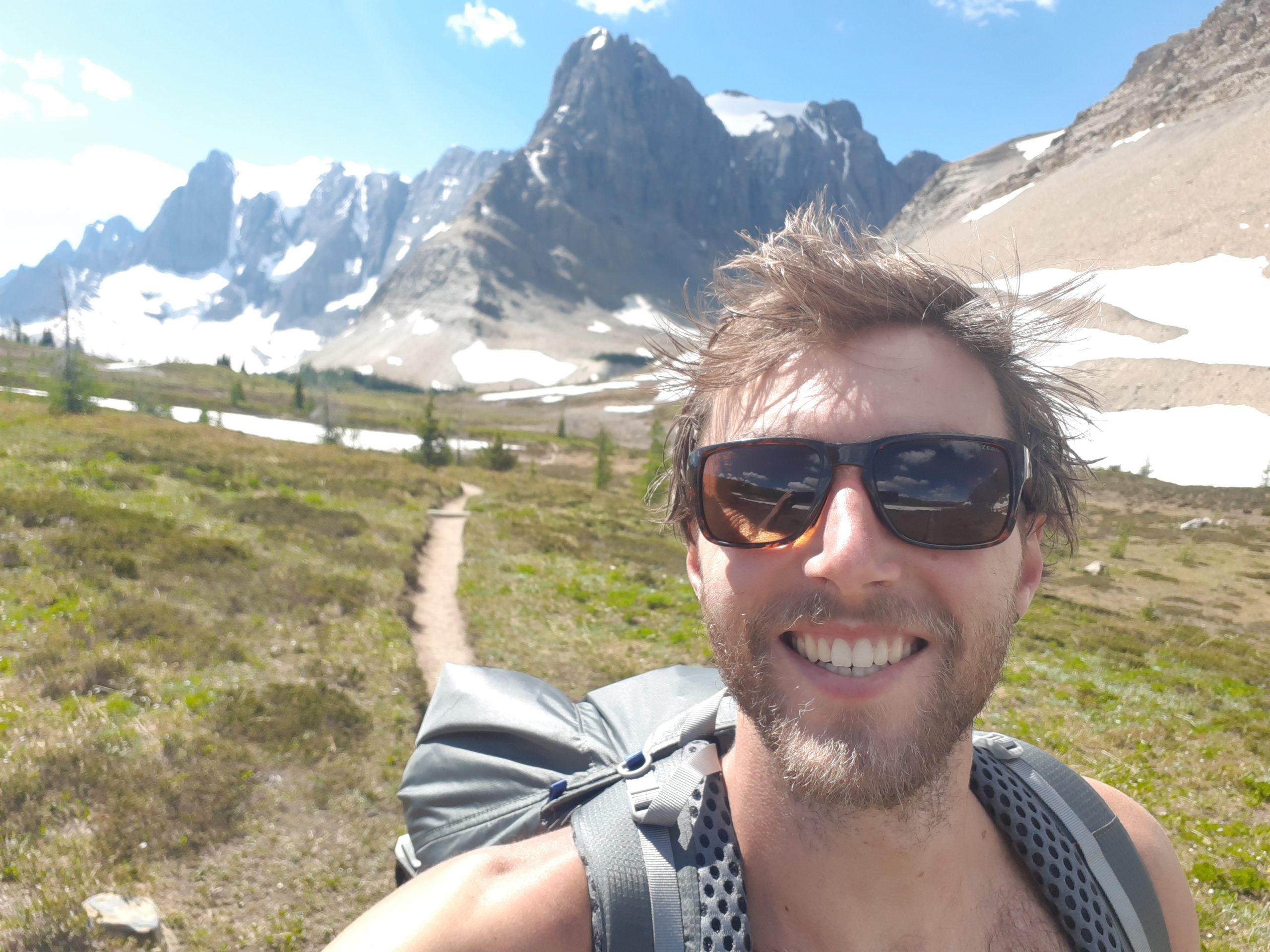
The image at the top is a great example of route-finding and off-trail travel. It’s a picture of our 100km (60mile) hike last year in Section E. Below is a picture of the Rockwall Trail! You can see how perfect the trail is which sure makes kilometers come easy.
We also chose to link up sections F and G together. There is an option to resupply at the end of section F but this includes a 23km side hike, called the Berg Lake Trail. We actually did this trail last year and it is insanely beautiful. We weren’t really interested in adding 46km for a food resupply when we could just put all that energy into heading towards the finish.
Finishing the Hike
The GDT ends at Kakwa Lake, but just because you made it to the end doesn’t mean your hike is over. At the end of the trail you are left with 3 options. Option 1 is hiking back to “civilization” which involves a 75km (46miles) walk along a forestry road, then spitting you out onto the highway. Hopefully, here you can catch a hitch or arrange for someone to pick you up. Option 2 is hiring a floatplane or helicopter to pick you up at Kawka Lake, which means no extra hiking! Option 3, which we are going with, involves hiking around 30km (20miles) to the trailhead of Kakwa Lake and then hiring someone to pick you up.
The road condition is always changing and I’m under the impression they have a side-by-side to pick you up if the road is impassable to cars. Well worth the money! We have also arranged to leave our vehicle with our ride out of Kakwa. The company is called Robson Valley Unplugged and they seem to have really found a niche for helping out hikers. We also are avoiding the hitch at the end by finishing at our vehicle. It will be a few hundred bucks but I’m expecting it will be worth it rather than a 2-3 day hitch back home.
The next post will be about the reservation system and the hurdles particular to the GDT!
If anyone has any questions, especially stupid questions, please leave a comment! I’ve had tons of questions and they are super helpful at shaping what I want to talk about. They also help remind me what people may or may not know, whether it’s about long-distance hiking or not let the questions fly!

This website contains affiliate links, which means The Trek may receive a percentage of any product or service you purchase using the links in the articles or advertisements. The buyer pays the same price as they would otherwise, and your purchase helps to support The Trek's ongoing goal to serve you quality backpacking advice and information. Thanks for your support!
To learn more, please visit the About This Site page.

Comments 1