 ">
">
The Great Range Traverse: Tackling the Premier Adirondack Hiking Challenge
For hikers looking to tackle one of the toughest challenges in the Adirondacks, look no further than the Great Range Traverse. Often compared to the Presidential Traverse of New Hampshire, the route gains nearly 9,500 vertical feet of elevation over 26 miles as it traverses 10 summits with eight peaks over 4,000 feet.
The route reaches its apex at the highest summit in New York, 5,344-foot Mount Marcy. Along the way, expect some of the East’s toughest terrain with numerous steep scrambles, ladders, and even a section utilizing a cable for aid on a long slab. With so many summits along the way, mountain views appear around every corner.
Great Range Traverse Quick Facts

Length: 26 Miles
There are several variations of this traverse. The most common traverse includes the full Great Range from Rooster Comb and ends on Mount Marcy, which totals 15.5 miles.
From Mount Marcy, some choose to continue the hike to the Adirondack Loj. To avoid the need to shuttle from the Loj, continue to the Garden Trailhead via the Phelps Trail for 9.1 miles as described below.
Hiking to the Garden puts the route at 24.6 miles. An additional 1.8-mile downhill road walk connects the Garden to the Rooster Comb Trailhead, completing a 26.4-mile continuous loop.
Location: High Peaks Wilderness in the Adirondacks of New York.
- Rooster Comb Trailhead: 44.185408, -73.786715
- Garden Trailhead ($10 parking fee): 44.188986, -73.816074
Trail Type: Loop (when descending via the Phelps Trail).
Scenery: Dense forests give way to mountain panoramas on the summits with alpine areas on the highest peaks and creekside hiking in the valley.
Approximate Time to Hike: Two to three days to backpack, although single day traverses are fairly common.
Guide Book and Maps: The Adirondack Mountain Club’s High Peaks Trails 14th Edition features the most up to date trail details.
The National Geographic Trails Illustrated Map 742: Lake Placid/High Peaks and the Adirondack Mountain Club’s High Peaks Adirondack Trail Map both provide detailed information.
These guides can also be found at local retailers or at the Adirondack Mountain Club’s online store.
Terrain

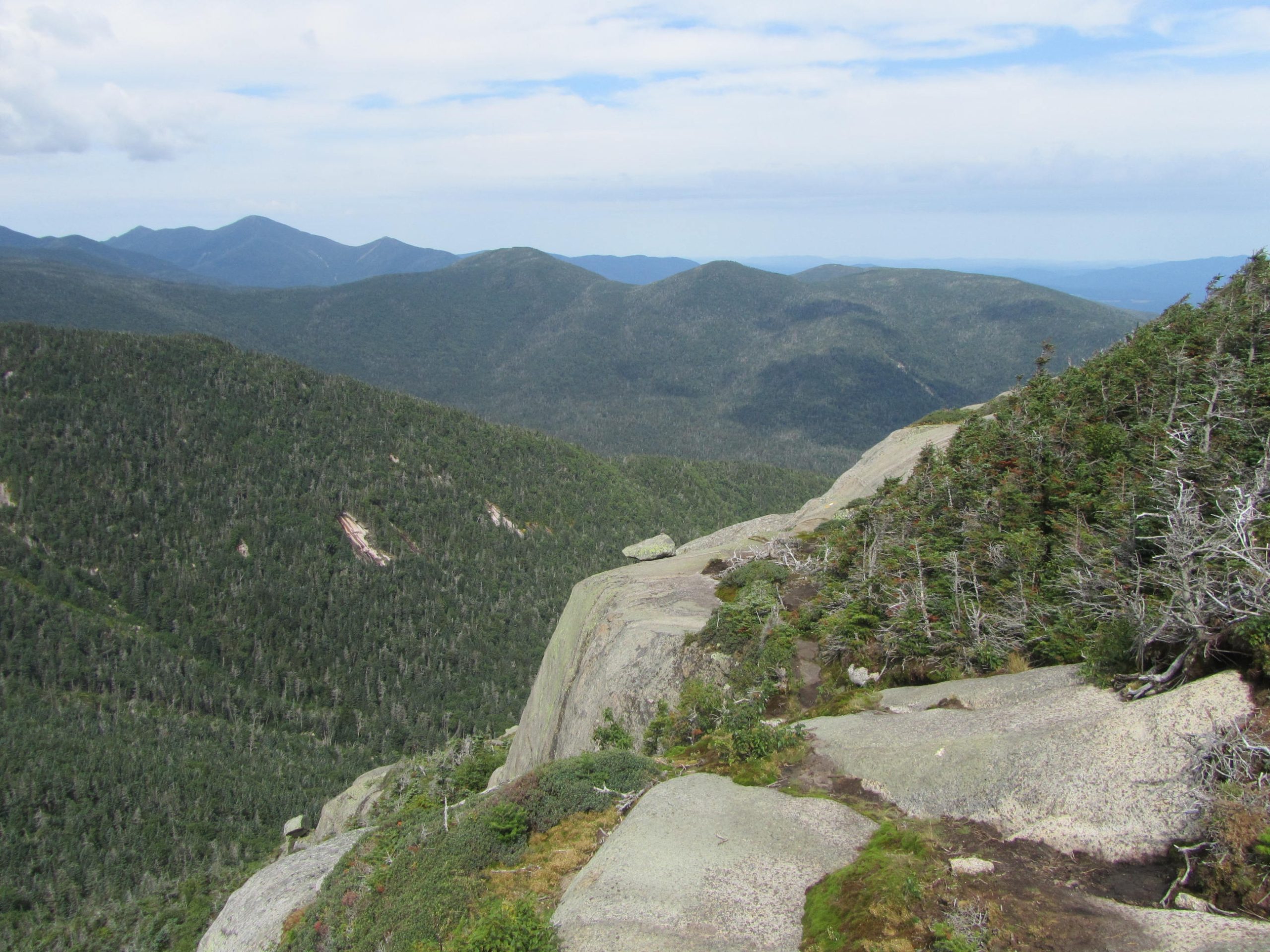
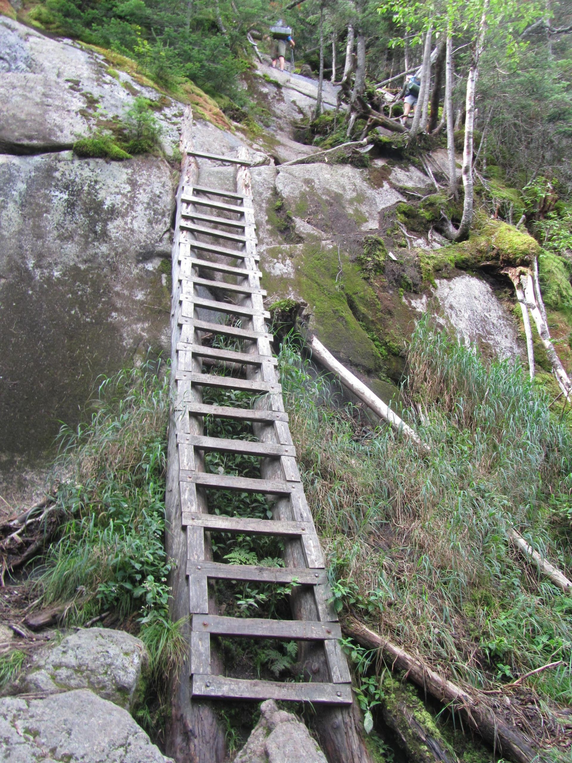
The route travels some of the most strenuous terrain in the Northeast. Adirondack trails are notoriously steep and unforgiving. The main part of the range continuously changes elevation on steep and uneven pitches over rocky terrain. Ladders assist in steeper sections.
The route negotiates a steep slide on Gothics with a bolted cable in place to assist hikers. A steep scramble over ledges with an exposed drop on Saddleback Mountain may deter hikers with a fear of heights. The terrain becomes rather easy along the Phelps Trail after it descends from Mount Marcy.
As with any hike in the region, the Adirondack trails hold mud longer than many other places. Muddy sections often utilize bog bridges and rocks to avoid the worst sections. Even with logs and rocks, expect some unavoidable mud in all but the driest years.
Getting There

The best trailheads to access the route are located just outside the hamlet of Keene Valley.
The Garden trailhead often fills early and costs $10 to park per day. From the center of Keene Valley on Route 73, a sign marks the turn for the Garden. The road ends at the 1.6 west at the trailhead.
The Rooster Comb trailhead sits 0.4 miles south of the turnoff for the Garden in Keene Valley along Route 73.
Direction

Although the route can be hiked either direction as a loop, most people travel clockwise starting at the Rooster Comb Trailhead. The climbing begins out of the gate with the lowest peak first when headed clockwise. The mountains generally become higher as you head clockwise, ending at the route’s high point on Mount Marcy. After leaving Marcy, the remaining 11 miles travel generally downhill.
Why Hike the Great Range Traverse

Hikers attempt the Great Range Traverse for a few reasons. They are trying to test personal limits on some of the toughest terrain in the East, bag as many peaks as possible on one trip, or looking to take in some of the finest mountain scenery the Adirondacks have to offer. The Great Range Traverse accomplishes all three of these objectives.
Highlights

Mount Marcy: Let’s start with the highest of the highlights. At 5,344 feet elevation, Mount Marcy stands as the highest point in New York with a large area of alpine terrain.
Mount Haystack: Reaching 4,960 feet, Haystack stands as the third highest peak in New York and features an alpine area above treeline with a more rugged feel than Marcy.
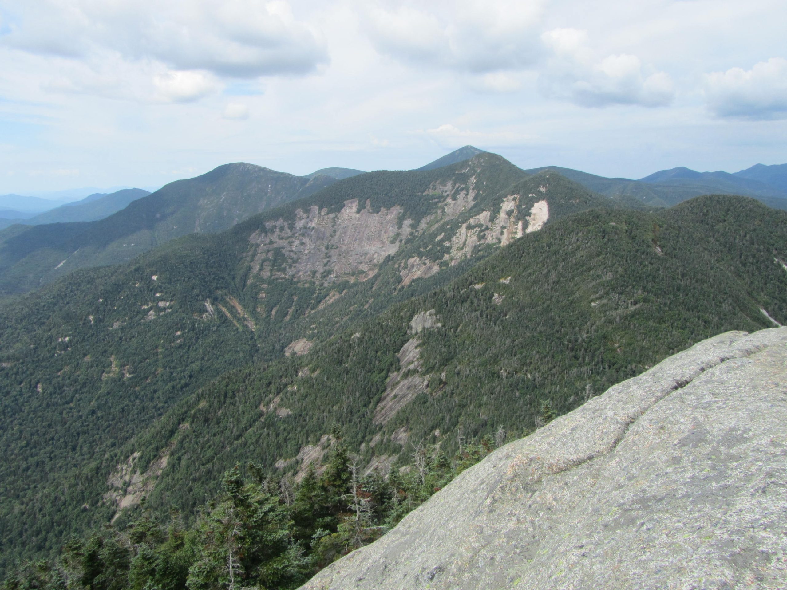
Basin Mountain: The ninth-highest peak in the state, at 4,827 feet, features grandstand views of Marcy and Haystack as it sits on the edge of the alpine zone.
Gothics: The 4,736-foot slide-scarred slopes and alpine summit of New York’s tenth-highest peak provide dramatic views and tough terrain, including a steep slide traversed by the trail with a long cable for assistance.
Saddleback Mountain: The 4,515-foot summit offers great views, but the real highlight that stands out is the near-vertical ledges that drop from the south side of the summit. The route traverses the ledges, requiring careful hand and foot placement to ensure safe passage. This is one of the most challenging sections of a marked trail in the Adirondacks and is even more complicated with a full pack.
Additional Summits: The traverse also climbs the 4,000-footers Armstrong, Upper Wolf Jaw, and Lower Wolf Jaw. The lower peaks Hedgehog and Rooster Comb are also climbed. With the exception of Hedgehog, all the peaks offer at least partial views at some point.
Bushnell Falls: Accessed by a steep-250 yard side trail, this beautiful waterfall is worth the detour, even with nearly 20 miles underfoot by the time it’s reached.
Weather

The Adirondacks aren’t known for cheery weather. Midsummer brings the best conditions, with valley temperatures typically in the 70s during the day and 50s at night. Days reaching the 80s aren’t uncommon. Expect temperatures as much as 20 degrees cooler on the summits above 4,000 feet.
By September, the temperature begins to cool dramatically with less humidity. You should be prepared for freezing temperatures, even in the valleys.
Snow typically begins falling in October and the ground remains covered consistently by mid-November most years. Expect snow to linger at higher elevations through May. A full traverse in winter shouldn’t be attempted without expertise in winter travel in the mountains.
While the peak hiking season boasts dryer conditions, prepare for wet weather any time of year. Midsummer offers the best opportunity for dry weather, but showers are common in the mountains even when surrounding areas remain dry. Spring and autumn tend to see more wet weather than summer.
Significant temperature drops are not unusual during rainy weather in the Adirondacks. If possible, postpone a trip during extended periods of wet weather to avoid the elevated risk involved with hiking on wet slides and rock scrambles.
Gear Suggestions

Bear Canister: A hard-sided bear canister is required for overnight stays within the Eastern High Peaks Wilderness. Ursack products are not permitted. The Adirondack Mountain Club and local outdoor stores such as EMS in Lake Placid and The Mountaineer in Keene Valley rent the canisters.
Warm Clothing: The temperature drops dramatically on the summits. Expect exposure and wind at higher elevations with several peaks rising above treeline. Be prepared with appropriate extra layers.
Rain Gear: Even with a solid forecast, the Adirondacks make their own weather and showers are always a possibility. You should always be prepared with adequate rain gear.
Gaiters: Mud lingers in the Adirondacks long after wet weather. Low gaiters may help protect your shoes and feet.
Bug Protection: Black flies love the Adirondacks. Trips in spring and early summer guarantee black flies. The flies linger until early July on the summits. Some form of bug protection is highly recommended. Insect repellent, a head net, and permethrin treatment for clothing and gear will go a long way toward preserving your sanity.
Camping and Water Sources

Along the high elevation stretch between the Rooster Comb trailhead and Mount Marcy, camping and water are both limited. Camping above 3,500 feet is prohibited with the exception of Sno-Bird campsite, 12.2 miles from the start. The only reliable water source during this stretch can be found by the campsite.
Due to rough terrain, dense forest, and elevation, a reliable and legal spot to camp may be difficult to find without dropping off-route to designated sites at lower elevations.
After descending Mount Marcy via the Phelps Trail, the trail routinely travels along creeks. In the seven miles between Slant Rock and the Garden, the route passes numerous designated campsites and lean-tos. Three and a half miles before the Garden, the trail reaches Johns Brook Lodge. This backcountry lodge offers meals and bunk rooms during the summer season for a fee.
Closing Thoughts
Beginners may want to avoid the Great Range Traverse due to the strenuous terrain and trail conditions. Experienced hikers will find the route challenging and rewarding. The route provides the opportunity to travel over 10 summits, including a state high point, while taking in some of the finest mountain scenery in the region.
Even though single day traverses are not uncommon, you may just want to take your time to enjoy the abundant scenery and vistas that the route packs in over its course.
Additional Resources
- Adirondack Mountain Club: The Adirondack Mountain Club has information on all recreation in the Adirondacks and sells publications including guides and maps
- New York State Department of Environmental Protection High Peaks Information: Special regulations and updates specific to the High Peaks Wilderness from the managing agency of the region
- Adirondacks High Peaks Forums: Forums dedicated to the High Peaks with trail conditions and good information
- The Great Range Traverse: The author’s firsthand account completing a single day Great Range Traverse
Featured image: Graphic design by Sophie Gerry.

This website contains affiliate links, which means The Trek may receive a percentage of any product or service you purchase using the links in the articles or advertisements. The buyer pays the same price as they would otherwise, and your purchase helps to support The Trek's ongoing goal to serve you quality backpacking advice and information. Thanks for your support!
To learn more, please visit the About This Site page.

Comments 1