 ">
">
The Zion Traverse: Hiking Off the Beaten Path in Utah’s Most Popular National Park
Very rarely do I immediately want to repeat a trail I just hiked. Every rose has its thorn, and whether you’re hit by heat, deep sand, brutal climbs, or high elevation, Utah does not deal challenges sparingly.
Though the Zion Traverse has extremely challenging moments, it’s one of my favorite trails I’ve ever completed. My best friend Alex and I did it in a single day this past April and have been raving about it for the past few weeks. As is typically our style, we threw together plans in the 11th hour and somehow pulled it off with no major meltdowns.
The route we did went from east (The Grotto Picnic Area) to west (Lee Pass/Kolob Canyons). This was 37 miles and 7,200 feet of elevation gain. When the route was originally created, it started at the East Rim Trailhead and was about 50 miles. However, this section of trail has an “indefinite closure due to damage” (NPS, 2020).
For the sake of this profile, I’m going to write up the 37-mile version so as to not confuse hopeful hikers. Hopefully in the next few years, this section will reopen, and I’ll have to do the full thing just for the sake of updating this profile.
The Zion Traverse at a Glance

The landscape changes drastically throughout this route.
- Distance: 50 miles (original) / 37 miles (modified)
- Elevation gain: 8,500 ft (original) / 7,200 ft (The Grotto to Lee Pass) / 5,000 ft (Lee Pass to The Grotto)
- Difficulty: Moderate
- Days to hike: 2-4
- Camping options: Established backcountry campgrounds, or detours on forest service roads
- Permit required: Yes if camping
- Water availability: Limited, water drops encouraged
- Best time of year: April – May or September – November
- Terrain: High desert – dirt trails, deep sand, paved paths
Why Do the Zion Traverse?

We didn’t see another single human on this four-mile stretch of absolutely gorgeous trail
In 2021, Zion was the second most visited national park. To some, this may seem alluring, while others may be tempted to stay away because of the crowds associated with the park. While the main Zion entrance and the nearby town of Springdale certainly boom with tourists, there are corners of the park where you’d be lucky to come across other hikers. These hidden gems are what make Zion a world-class destination for climbers, canyoneers, and backcountry explorers.
The Zion Traverse starts smack dab in the center of all the action: Angel’s Landing Trail. After two miles, it splits with the popular flow of traffic and immediately the people are reduced by about 99%. We did the Zion Traverse on a Saturday in late April and had multiple 5-plus-mile stretches with just each other as company. This route truly gives you the entire Zion experience. You get a taste of what brings so many to this magical place every year, as well as less explored areas with more subtle desert beauty.
Which Direction Should You Go?
This trail is very different depending on which way you go. The Grotto to Lee Pass has 7,200 feet of gain, with most of it being in the first 5 miles. From there, the trail is mostly rolling and the miles start to cruise. Conversely, Lee Pass to The Grotto starts out relatively mild and flat, then has an extremely long and steady climb. This all leads into a sharp 4,000-foot descent at the very end of the trail.

It was really inspiring to start our trip by climbing up the Angel’s Landing Trail. Also, it gets the most crowded area over with at the very beginning.
The Grotto to Lee Pass (East to West)
Pros
I absolutely loved starting our trip by climbing out of Zion Valley and up the Angel’s Landing Trailhead. I had never been to Zion before and was so inspired by the towering canyon walls and orange features in the distance. Also, with this direction, you get most of the climbing done in the first few miles. Once you get to the end, all you have to do is catch your ride and get back to the shuttle stop where you left your car. Getting the shuttle portion over with early in the day leaves fewer logistics at the end.
Cons
You can’t start whenever you want; you’re reliant on the shuttle service. The shuttle is super crowded first thing in the morning, so you end up having to bake an extra half hour or so into your day for that whole ordeal. Also, you start off the day with 4,000 feet of vert. If you’re prepared, it’s nice to get it out of the way, but if taken too hard it has the potential to cause lingering fatigue for the rest of the trip. Also, you reach the sandy section towards the end. Slow miles when you can see the finish line are very disheartening.
Lee Pass to The Grotto (West to East)
Pros
If you’re not in quite as good of shape, this route has less overall vertical gain (about 5,000 ft) and only a few steep climbs. Plus, you get the sandy section done pretty early on. You also don’t have to deal with the shuttle service at the beginning of the trip, so you can start at any point during the day and don’t have to deal with crowds right when you hit the trail. You also end on a high note – descending into Zion Valley for your last few miles.
Cons
The biggest con I would anticipate here is having to coordinate your ending time. The shuttle only runs until 7:00 pm, so you’d have to be sure to finish before then. Also, having to wait for a bus and then shuttle with a ton of humans back to your car is kind of a drag at the end of an epic trip. Also consider if your body will be able to handle a ton of steep descent at the very end of a day, or if your knees might prefer ending gradually.
Transportation
Our transportation logistics simply included parking at the visitor’s center shuttle stop and securing a ride (thanks Chris) from the end back to the start.
No private vehicles are allowed into Zion National Park at the main visitor’s center entrance. This is where The Grotto Picnic Area and Angel’s Landing Trailhead are located. Because of the East Rim closure, this is now the Eastern Terminus of the Zion Traverse. So, you’ll have to take a shuttle either at the beginning or end of your trip. The shuttle system is easy to navigate and does not require reservations. You can park overnight at various areas outside of the park as you hike the trail.
From one end to the other, there are no public transportation options. If you’re going solo, you’ll have to figure out a ride. The journey between the two is just about an hour, so it’s not too big of a favor for someone coming to join you for a post-hike campout :). If you’re going in a group, it only adds an extra hour to the drive down to stage a car at the end of the trail.
It’s technically possible to avoid having to shuttle from The Grotto if you’re willing to do a five-mile road walk. It’s five miles from the National Park Visitor’s Center (where you can park your car) to The Grotto. This would allow you to get a really early start if you’re heading Westbound, or finish as late as you need to when going Eastbound.
During peak season (summer), there are more frequent shuttle and options much earlier in the morning. However, this is when it’s hottest and most crowded in the park and at nearby campgrounds. I don’t recommend choosing to do this trip during peak season unless completely necessary.
READ NEXT – Rim-to-Rim-to-Rim: Backpacking Guide to the Best of the Grand Canyon
Camping On the Zion Traverse / Permits
Permits are absolutely required when backcountry camping in Zion. All of the campgrounds are established and well-marked. This website lays out in detail how to make a reservation for a wilderness area. The three areas that fall along the Zion Traverse route are West Rim, Hop Valley, and La Verkin Creek. These are listed in order if doing the route from East (The Grotto) to West (Kolob Canyons).
If you don’t have a permit in advance, the hike *can* be done in a day. We did it as a trail run, so we moved as fast and light as possible. It took us about 10 hours in total. If you don’t want to do the entire 37 miles in a day, it’s possible to do it as a section hike as well. You can shorten it by making either Hop Valley or the West Rim Trailhead one of your termini. These areas are described in greater detail below.
There are no permits required to simply do the trail. However, if you want to tack on Angel’s Landing, you do now need a permit for that quick detour. More information about that here.
Water Sources

Water cache stops were pretty much necessary but very easy to plan out.
We didn’t drink a drop of water that crosses the trail. A toxic algae bloom affects the freshwater along the course, so we only wanted to filter in a dire pinch. Instead, we dropped two caches of water for ourselves the night before we started our run. These two areas were the West Rim Trailhead (mile 15) and Hop Valley Trailhead (mile 24). This added two total hours to our drive down the night before, and it was absolutely worth it to hit both locations.
The West Rim Trailhead has no trash but is directly off the trail. However, Lava Point is a short detour and does have an established car-camping campground and a trashcan and toilet. We chose to crush and carry our gallon jugs out with us to Hop Valley rather than venture off our course.
Hop Valley Trailhead is right off the road and has large trash cans and pretty nice facilities (by pit toilet standards). There was also good service here. If I were to do this again in a single day and wasn’t fit enough to finish the whole thing, I would end here. Hop Valley is the start of the six-mile sandy stretch that threatened my sanity.
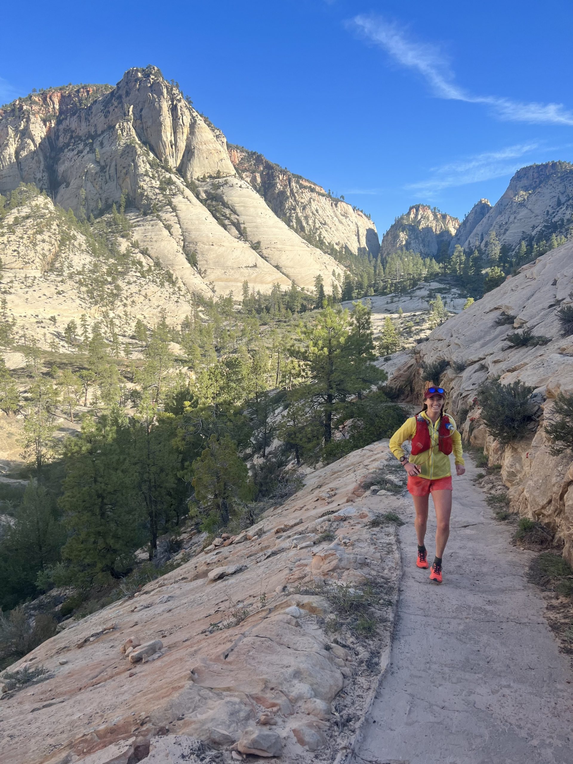
In an emergency, there is water along the trail that can be filtered. It’s not plentiful for the entire route, but in the Kolob Canyons / La Verkin creek area (last 13 miles) you’re passing water at least once a mile.
Best Time of Year to Hike the Zion Traverse
Spring in the desert = big smiles.
In Utah, many of us refer to the shoulder season months as “desert season.” It’s outside the heyday craziness of summer crowds and avoids the worst of the heat. Though it is possible to visit Zion during the winter, high levels of snow would make this trail extremely difficult. Additionally, the shuttle service is not running as frequently. Though the road to Kolob Canyons is most often plowed during the winter, it has the potential for closures due to high snow or ice. I think a winter section hike in Zion could be possible but only recommend it to those who are very familiar with the area and winter travel.
- April – May: Spring in the desert is absolutely magical. If you time it right. However, there’s always the potential for lingering snow to cover parts of the trail up high during a high snow year. On the other hand, by mid-May, you may be looking at close to triple-digit temperatures in some sections. We chose April 30th and were fairly lucky. Most of the day was between 70 and 75 degrees, with a few 80+ moments.
- September – October: Early fall is also a good option for long desert trips. By choosing this option, you won’t have to deal with as many river crossings in the Kolob Canyons section and still enjoy relatively milder temperatures. There won’t be as much water available on the trail, BUT because we didn’t filter any water along the way and simply relied on our caches. Though there is the chance that in October you may see some early season storms, you can count on fairly mild weather.
A Few Pro Tips

I’m so glad we made our one-day run into a three-day weekend trip. The camping outside of Zion is absolutely unbelievable.
- Plan an extra day (or two!) to camp outside the park. Zion has my favorite dispersed camping in the state. An extra night to gawk at the stars and see the canyons you crossed from a distance is 1000% worth it. There’s also an AMAZING coffee shop in the town of La Verkin, which I could easily spend all day at.
- Don’t get frustrated with crowds at the beginning. I almost shot my wad in the first mile by trying to run uphill around crowds clumping all over the trail. Yes, not everyone has the best trail etiquette. However, everyone has a right to see these absolutely amazing places too. Within an hour we were at the top of Angel’s Landing and saw fewer people the rest of the day than we did in those first 45 minutes.
- Give yourself extra time for the shuttle. The first shuttle of the day is PACKED. The National Parks Service doesn’t guarantee this, but they had four shuttles lined up to take the first batch of hikers. We got to the shuttle stop 15 minutes early and barely got on the third bus.
Safety Considerations: Heat, Water Sources, and Tricky Terrain

Running through this sandpit for 90 minutes in 80-degree heat is something I don’t necessarily want to repeat.
- Prepare. For. Heat. Even if the temperature says it’s a high of 70, prepare for 10 degrees hotter. Stifling air can sit at the bottom of canyons and absolutely smack you in the face during long sections of trail nestled between cliffs. We both had plenty of sunscreen, more than enough water, and long-sleeved sun shirts to keep ourselves protected. We also made sure to eat a lot very early in the day, so we could stock up on calories before the heat ruined our guts.
- Toxic water. As detailed above, we didn’t want to flirt with giardia. However, this also means that you don’t want to bathe or swim in any of the water. It’s very tempting to splash your face in the middle of a hot day, but we restrained ourselves. The water caches are really easy to do, and I cannot stress the importance of making these stops enough.
- Prepare for some tough sections. There are steep climbs, rocky narrow trails, and sandpits littered along this route. We went into the run thinking that it was going to be beautiful dirt single track the entire time. Though ultimately the sand was good on my joints, it made some sections much slower than we originally anticipated.
Closing Thoughts

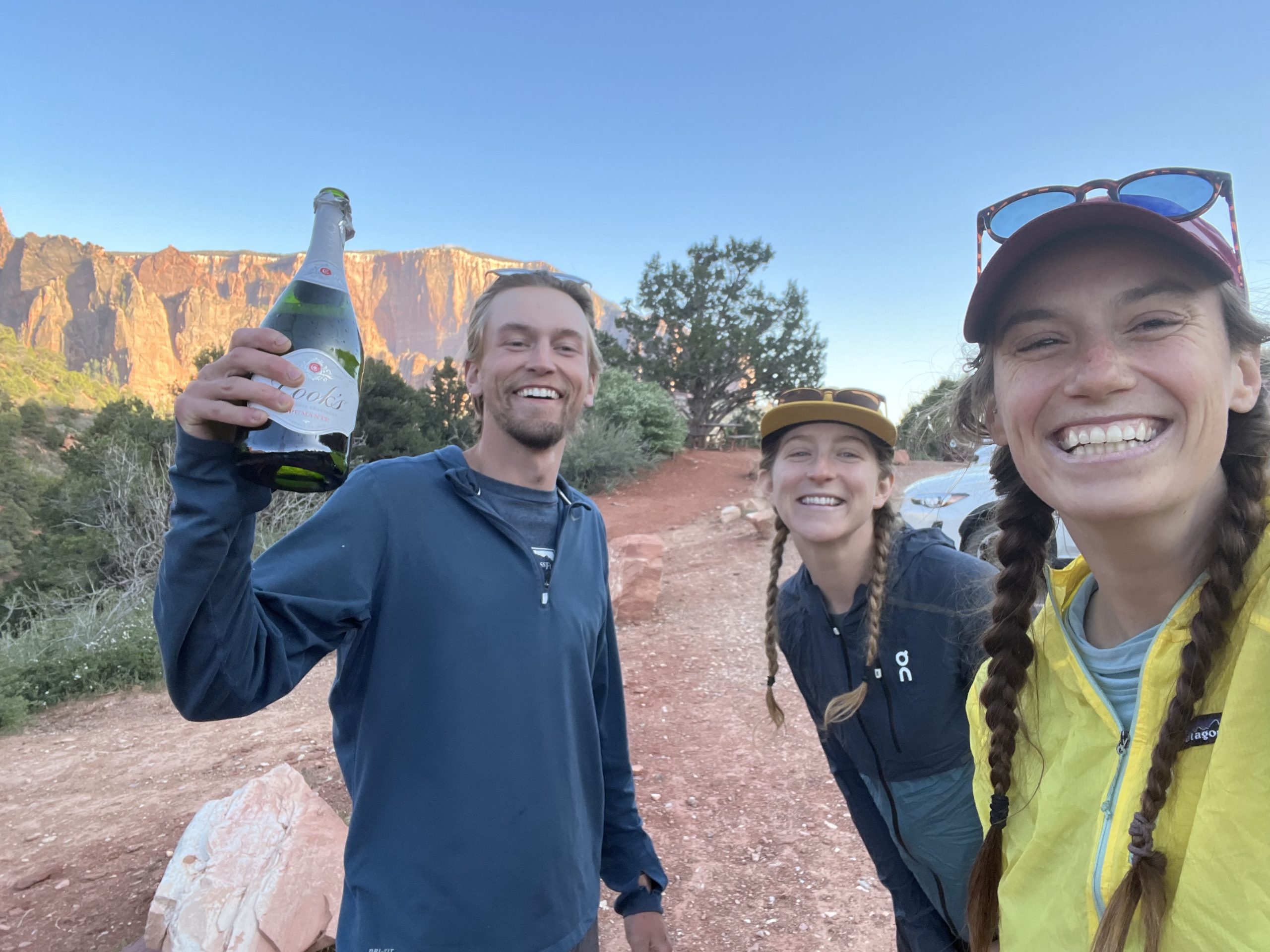
Our end-of-run ride arrived bearing a bottle of champagne. God bless him.
I’m already planning a trip back to the Zion Traverse in less than six months. The landscape is unlike anywhere else in this country, which is what draws so many visitors to Zion in the first place. However, hiking this route gives you the experience of seeing Zion’s most popular and photographed areas, as well as hidden gems where you’re unlikely to see many others. Though the desert means heat, long water carries, and sand, those towering red and orange canyon walls, vast landscapes, and enormous blue skies keep me coming back.
Featured image: Photo via Katie Kommer. Graphic design by Jillian Verner (@yourstrulyjillian).

This website contains affiliate links, which means The Trek may receive a percentage of any product or service you purchase using the links in the articles or advertisements. The buyer pays the same price as they would otherwise, and your purchase helps to support The Trek's ongoing goal to serve you quality backpacking advice and information. Thanks for your support!
To learn more, please visit the About This Site page.

Comments 2
Great trail story! The 3rd picture is not Angel’s Landing. That is Scout’s Lookout. Perhaps you knew that, but your story seems to say you went to Angel’s Landing. Angel’s Landing is another 1/2 mile across that craggy, narrow ridge to your left, right side of the picture. Doing it would have added probably 3 hours to your trip and running it would have been suicidal. Thank for the story. I really enjoyed it.
Thank you for your great story. I did the R2R2R recently and now I am preparing for this hike. Greetings from Germany. Zion is my favorite.