 ">
">
Three Lakes Wildlife Management Area to the Little Big Econ State Park on the Florida Trail
This is the land of a thousand parcels with a huge road walk in the middle. Mud, water, and cars abound.
Three Lakes Wildlife Management Area
This management area is what you hit after crossing the Kissimmee River on SR 60. But you don’t get there until completing a six-mile road walk on a busy 2 lane highway. There are wide grass shoulders for part of it, so you can avoid the traffic for most of it. There is enough room in places to be able to take a break, but not much shade.
Entry into the area is down a dirt road two miles or so before the trail enters the woods again. There is a hunt station and hunt campground with a hand pump. Many of these wildlife areas have hand pumps, but you still need to treat the water.
It is another floodplain with ample opportunity to get your shoes covered in mud and the occasional calf-deep water traverse. It is definitely a challenge to keep dry feet.

With the swampy Savannah floodplain also comes limited spots for camping. There are plenty of dry places to be found, but they can be far apart. It is similar terrain to the Kissimmee Preserve State Park.
The Management Area is named for the three lakes in the area, Lake Kissimmee, Lake Jackson, and Lake Marion. It is a large area of 62,000 acres and Wikipedia says it is the second-largest open dry prairie in the United States.
Dry is in the eye of the beholder, but it was far driver than I expected something called a floodplain to be. Especially considering a hurricane deposited record amounts of rain on this part of the state just four months ago.

You exit this WMA with another road walk. This time on US 441. It is only about three miles long and the traffic is not nearly as heavy as I was expecting for a two-lane highway. It has a picnic bench near the midpoint, but no other services.
Forever Florida
This next section goes through a private preserve that is no longer open as a tourism destination but is still open to thru-hikers. They have one campsite that you can still use if you call ahead to receive permission.
The terrain is open palmetto and pines. There are a few cypress domes and opportunities to get your feet wet. But the majority of the wet spots have really nice boardwalks over them.
But the major excitement of this section is an animal rescue near the beginning. It is the Central Florida Animal Reserve. They specialize in big cats and as you hike by you can hear them talking to you. I was able to see a male lion, but the other cats were bedded down or hiding.
Bull Creek Wildlife Management Area
The trail transitions into the next WMA without much notice other than a style over a fence. This one is like the previous ones with the same palmetto pine vegetation, multiple hunt check stations, and areas of mud and water.
There are high-water alternate trails in many of these floodplain areas. Since the water in general has been higher than normal I have been taking most of these alternates. But nearly all of these alternates also have water or muddy areas to deal with. Life in Florida.

The most important aspect of Bull Creek is the Jane Green Camp. It is the last campsite before the beginning of 30-mile road walk, so it is an important staging area to prepare for that.
The campsite itself is high dry pines with grass and tons of space for dozens of tents. It also has a very nice hand pump.
I got here early in the afternoon and decided to stop and rest the rest of the day before the big round walk. It gave me some time to catch up on chores and dry out some of my gear.
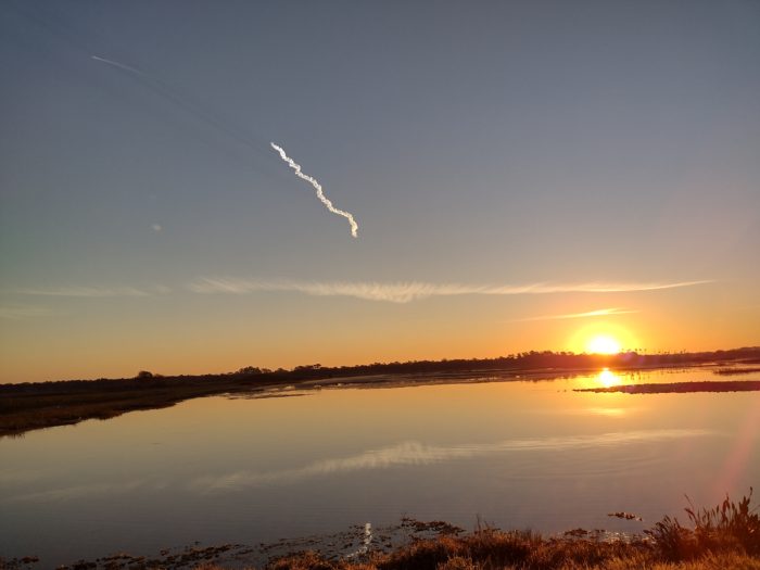
An unexpected bonus at this campsite was being able to see a SpaceX launch. Justice for sunset there was a launch of a Falcon Heavy rocket. The campsite is less than 40 miles from the launch pads at Kennedy Space Center, so the view was pretty outstanding.

You could follow the two boosters doing their reentry burns and returning to the Space Center after the main rocket continued on to orbit. As a former Space Center employee, it was a really nice bonus to be able to see that.
The Deseret Road Walk
This is a section that most people dread on the Forest Trail. It is a section of 30 miles of road walking. There are no services along the road walk unless you’re lucky enough to meet the 520 fruit man.
The road walk is actually five different roads. It begins on 192 that leads into Melbourne. This one is only about three miles but is very high-speed four-lane traffic. The grass shoulder is sometimes good and sometimes bad. The traffic is always bad. There are no stealth camping opportunities on 192.
The next road is Deer Park Road and is the long one at about 13 miles long. This is the road that takes you through the center of the Deseret Cattle and Citrus Ranch.
There are no services other than the occasional creek that the road crosses over. But all of the creeks are considered polluted because of the biosolids application that the ranch uses on their property. There is a water cache along the road about 6 miles in with a really nice bench under a tree to rest up.

There are shade trees every half mile to a mile on the first half of the road. The second half has far fewer trees. There are gates every few miles that you can duck into to get further away from the road without trespassing to take a break.
There are very few opportunities for stealth camping along this road. Along most of the road, the cattle property comes right up to the right of way.
The road itself is two lanes and has a light amount of traffic which seems to vary quite a bit on the north half and south half. Traffic is a mix of passenger vehicles and large trucks.
Nova Road is the next section. It has far more traffic than Deer Park Road and is also two lanes. The grass shoulder is not terrible.
There are many stealth camping opportunities on this road. But all of these opportunities are within 30 yards of the roadway. If you are a light sleeper you will not be sleeping. I would not feel comfortable at any of the sites.
The next road is even busier, and I knew that there would be very little, if any, opportunities to stealth camp on that one. This is when I begin to hatch a plan to hitchhike into Cocoa and grab a hotel.
The fourth Road in the road walk is State Road 520 leading into Cocoa and Cocoa Beach. It is a four-lane highway with lots of high-speed traffic. The grass shoulder is wide and decent. You are walking along this road for about 6 miles.
If you are lucky and arrive on a weekend Friday through Sunday or a holiday, there may be a fruit stand a quarter mile to the east when you intersect with 520. If he is there then consider this a mandatory stop.
His family has been running this fruit stand for nearly 30 years. And he is one of the nicest people you were ever meet on this planet. He loves hikers and will go out of his way to help anyone in need.
The road walk itself is not too bad. The shoulders are decent and there is enough room at the overpasses of creeks which is not always the case when you are road walking.

I didn’t really see any good places to stealth camp, but then I wasn’t looking. I did end up acting on my plan to go into Cocoa and grab a hotel. I even upgraded it to going to all the way to Cocoa Beach and grabbing a nice hotel on the beach.
A little bit further east from the fruit stand is a loop trail that is part of the Florida Trail network. It does not list that there are any campsites but at least you could get further away from the road if you wanted to try to stealth there.
This is where Marriott points come in handy. The hotel is free, but there is still the cost of an Uber. it’s easy to hit you into a place like Cocoa or Cocoa Beach from the trail. But it would be very difficult or take forever to try and hitch back out to the trail.
The last Road in the road walk I thought was State Road 528 to Cape Canaveral. But it turns out you are actually on a side road called Yates Road. This is a small two-lane country road with almost no traffic on it. It is only one mile in length. It was quite pleasant.
Since this ended the Deseret Ranch road walk, there is a water cache and a sign indicating the location of the water caches on the road walk southbound. I didn’t see one on the south side, but I bet there was one. Since I had rolled out early in the morning and wasn’t looking, I probably walked right past it.

A very detailed sign awaits SOBOs about to hit the Deseret road walk that just finished for me.
Tosohatchee Wildlife Preserve
Now you enter another Wildlife Preserve, the Tosohatchee. You must telephone the office and let them know when you are entering and exiting The Preserve. There are campsites within the Preserve, but it only takes a few hours to hike through so most people do not.
It is part of the St Johns River floodplain so it is not all high and dry. The first quarter mile is nearly all wading through water. There are several muddy sections and one or two shorter areas where you need to wade through water.
When I passed through they were having an active wild hog hunt. When you call in to register your entry they will let you know of any active hunts. I wear a red shirt and a blaze orange hat for such occasions. I could see Hunter’s driving down the roads in various places but I never saw them actively hunting.

Christmas Time
In this part of the trail, it is always Christmas. That is because you are hiking across the town of Christmas, Florida. There is a fort in the area but the real draw is the post office. I understand thousands of letters are sent here just to be postmarked from Christmas each holiday season.
What the town consists of for the hiker are two convenience stores about a half-mile off the trail. I stopped at the nearer one because I am a sucker for a sandwich and an ice cream cone. It just means I will not be eating more of the food I am carrying. First-world problems.

The gate that leads into the small town of Christmas, FL.
Seminole Ranch Conservation Area
After passing through the tiny town of Christmas you enter another conservation area. This one introduced more oaks but still had plenty of cabbage palms and we’re still in a moist area.
The official trail stays in the conservation area, but the wetlands park is an alternate blue blaze. This is where I took a detour to visit an adjacent property the Orlando Wetlands Park. It is a huge Wetlands Park that is just teeming with birds and other critters.
I went there in the morning to witness another SpaceX Falcon launch. The lunch was at 7:24 a.m. and was an absolutely magnificent view because of no vegetation nearby and the rising sun off to the side. I think this launch was a polar orbit so the booster landed in the ocean and I didn’t get the witness that part of the launch.
This is an area of wilderness in close proximity to houses. It pops in and out of neighborhoods and crosses small roads as the trail winds its way west. There were a few muddy spots but nothing significant.
Charles Bronson State Forest
No, not that Charles Bronson.
This state forest is a mix of pine, palmetto, and scrub oak. This also might have been one of the dryer areas I walked through in the last few weeks. I can’t remember if I even encountered any mud or water. I think there might have been one toward the end.
There is also another huge one-way alternate that goes north through the property and has nothing to do with the Florida Trail proper. This trail goes right at the edge of the St. Johns River and the Econlockhatchee River, which comes into play further north on the trail. If you were to take this long alternate, you could reconnect with the Florida Trail just south of the Charles Bronson WMA and miss out on the Chuluota and Mills Creek sections. I might have to go back one day and check out what this alternate offers over the official route.

A typical view in Florida – pines and palmettos.
Chuluota Wilderness Area
This section was indistinguishable from the State Forest other than beginning with lots of puncheon boards and several areas that still needed puncheon boards. It got a little bit goopy.
You can tell at this point you are getting closer to the suburbs. There are neighborhoods off into the distance and you can see houses occasionally.
Mills Creek Woodlands
There was a short road walk of less than 2 mi to get to the next section.
Suburbia begins to increase in this section. The vegetation itself remains much of the same. I don’t remember having to walk through any motor water in this section.
There had been a controlled burn within the last few days. So there were several miles of scorched ground and a spot or two still smoldering. You don’t want to camp in this area unless 100% of your gear is already black.

Little Big Econ State Forest
This is one of the crown jewels of the Eastern route through Central Florida. The Econ River is a fairly large tannic River with white sandy beaches and high bluffs all around it. It is like the Suwannee River in miniature scale.

A severe storm late last year has taken out one of the bridges over a ravine. The FarOut app has posted a rerouted trail to bypass about half of the length of the river. There are no Trail closed signs posted on the ground, however.
I took the official Trail since it is not officially closed. I am glad too because this Trail is as beautiful as I remember it from 25 years ago when I hiked it for the first time.
The bridge in question is indeed out. And it is indeed a necessary bridge over a ravine that is at least 15 ft deep. The bridge is completely missing but the debris has been stacked about halfway up the ridge to make a makeshift bridge. There is also a very large dead tree over the ravine that you could walk across if you are not afraid of heights. It is definitely passable but will have to be closed off when reconstruction begins.

Many people choose to camp in the later sections of this state park. There are official campsites that require reservations and a fee. But I think most people are stealth camping.
I am going into the town of Oviedo tonight because I have developed a leak in my air pad and need to do a makeshift repair in a bathtub. More Marriott points and more Uber dollars. I might have to change my name to Platinum Gill.
By the way, the pizza shop in Oviedo square is quite legit. They only have afternoon hours but they know how to make a pie. Order a margarita pizza with oil. If you order it with red sauce you will ruin it. Trust me.
Pick one Emotion
There was a mixture of many emotions in this section. The dread of more mud and waiting through the water. The dread of a very unpopular road walk. The anticipation and excitement of walking through the Orlando suburbs. The surprise of not one but two SpaceX launches.
But I have to pick just one.
So I pick surprise.
The amount of water and mud to deal with was a bit of a surprise. It is called the St Johns River floodplain so I’m not sure why I should be surprised, but I was. Even the Tosahatchee has always had the promise of waiting for the decades I have known about that section. But somehow I thought this doesn’t apply to me. Surprise, it does.
I was surprised at how not scary the big Deseret road walk was. Granted, hitching into Cocoa Beach made it a whole different event. I don’t want to say it was fun but I would not dread doing it again.
I was also surprised at having to have advanced reservations at many of the campsites ended up not being a big deal. I basically hiked right through nearly all of them.
I was also surprised to find that a high water alternate really doesn’t mean you are safe from water. That was the case in the Kissimmee River flood plain so why should it be any different in the St Johns River floodplain.
Surprise is a good emotion to have.

This website contains affiliate links, which means The Trek may receive a percentage of any product or service you purchase using the links in the articles or advertisements. The buyer pays the same price as they would otherwise, and your purchase helps to support The Trek's ongoing goal to serve you quality backpacking advice and information. Thanks for your support!
To learn more, please visit the About This Site page.
