 ">
">
Trail Profile: South Dakota’s Centennial Trail
The Centennial Trail is a 123-mile trail that winds through the Black Hills of South Dakota. Traversing ponderosa-pine forests, pastures, and open grasslands, the trail passes by several lakes and numerous stream crossings. Exposure is negligible and the trail is almost entirely graded for stock, but there is plenty of climbing.
Centennial Trail At-a-Glance

Length: 123 miles (per the most detailed guidebook)
Expected Completion Time: 7-9 days (14-17 miles per day)
Location: The trail traverses South Dakota’s Black Hills, running north-south between Bear Butte and Wind Cave National Park.
Trail Type: Shuttle (end-to-end)
Scenery: Rolling hills, open grasslands and low mountains with elevations up to 5,800 feet. Predominantly ponderosa-pine forest with birch, oak, aspen, and other species, and semiarid grasslands. The trail regularly crosses creeks and passes several lakes.
Terrain: Easy to strenuous. Keep in mind that there there are climbs of 2,000-3,000 feet, and overall elevation gain is 20,000 to 22,000 feet, depending on direction of travel.
Navigation: Mostly (but not entirely) well-marked. Tread is hard to find in places, and markers are occasionally AWOL, necessitating basic route-finding.
Centennial Trail Access

Hot Springs, 12 miles south of the southern terminus of the Centennial Trail, is a historic town offering hot springs, restaurants, and the Mammoth Site, a remarkable, active archaeological dig. Clay Bonnyman Evans photo.
Southbound: SOBO thru-hikers start at Bear Butte State Park, six miles northeast of Sturgis, SD.
Northbound: NOBO thru-hikers start in the middle of Wind Cave National Park, 12 miles north of Hot Springs, SD.
Hikers can drive fairly close to either terminus, but cannot park long-term at trailheads. Ride-share apps and services are the best bet for transportation to the trail. Flights are available and rental cars can be dropped off at Rapid City Regional Airport.
Rapid Shuttle picks up passengers at the airport; costs as of September 2019 were $75 to Sturgis (my shuttle driver took me all the way to Bear Butte for $80 on request) and $120 to Hot Springs.
Thru-hiking is little known in the area, so trail angels and shuttles are all but nonexistent. But the trail passes close to small towns, stores, and other potential resupply spots, so shuttles are generally not needed.
Maps and Guides

The bison skull logo can be found on posts and nailed to trees, marking the trail. Clay Bonnyman Evans photo.
Section mileages can vary between various maps and guides. Options include the National Geographic Trails Illustrated Black Hills Map Pack Bundle, US Forest Service literature, and the 2018 guidebook, Hiking Centennial Trail: A Guide to Hiking South Dakota’s Centennial Trail.
The guidebook describes a northbound hike, but southbounders won’t have trouble reading it back-to-front.
Direction of Travel
The Centennial Trail in some ways resembles the Appalachian Trail: The northern part of the trail is more challenging and finishes on a dramatic, prominent summit with spectacular 360-degree views.
You can hike this trail either direction. Total elevation gain for SOBOs is about 22,000 feet, and for NOBOs about 20,000 feet (per the guidebook). SOBOs start with a steep ascent of Bear Butte, then go from 3,200 feet to more than 5,200 feet (with plenty of ups and downs) within 20 miles. NOBOs go from about 4,000 feet to nearly 5,500 feet over the first 23 miles, with a less jagged overall elevation profile.
Why Hike the Centennial Trail

The Centennial Trail is almost entirely graded for stock, but becomes steep and rocky in a few places. Clay Bonnyman Evans photo.
South Dakota’s Centennial Trail was built in 1989 to celebrate the state’s 100-year birthday. This is an excellent shorter long-distance route that offers plenty of challenge. Expect a rich experience, from the iconic Mount Rushmore to herds of wild buffalo and frequent views of rugged landscapes beyond the 100th meridian. Though traveling through forests for much of its length, this is no green tunnel.
The trail is remarkably uncrowded. I walked its entire length over five and a half days during excellent weather in late August and saw not one backpacker, perhaps 20 day hikers (total) around popular trailheads, and about 20 people riding horses or mules. If solitude in the wilderness is your thing, the CET is an excellent choice.
Hikers can walk from end to end in five days by averaging just under 25 miles a day, or seven days doing 17.5-mile days, which makes it possible to hike within a week’s vacation. It could be a nice introduction to long-distance hiking or a training hike for those set on a longer Western trail such as the Pacific Crest Trail or Continental Divide Trail.
And for those with time before or after doing the miles, there is a plethora of cool things to see within an hour’s drive of the trail, including Devil’s Tower National Monument, Wind Cave and Jewel Cave (third longest cave in the world), the Mammoth Site (an active archaeological dig), hot springs, and more. Bear Butte, the northern terminus, is sacred to American Indian tribes in the region.
Climate and Weather

The Centennial Trail opens up to frequent, long views on the surrounding Black Hills. Clay Bonnyman Evans photo.
The Black Hills (despite the name, they are indeed a mountain range) are generally dry, receiving around 20 inches of precipitation annually. In a typical year, hikers must pay close attention to water sources and be prepared to carry plenty in drier segments.
Temperatures vary greatly throughout the year, from average late-summer highs in the mid-80s to lows in the teens December through February, with occasional plunges below zero; dry air makes both extremes more bearable than in humid climates (hello, Pennsylvania). Late-spring or early-autumn highs are in the 60s or 70s, with lows in the 40s.
Gear Suggestions

Dalton Lake on the Centennial Trail. Clay Bonnyman Evans photo.
There are no shelters on the trail. A three-season tent and light sleeping bag or quilt should suffice from May through September, or even October, though it can snow in early fall.
Hikers should be prepared to carry up to four liters of water in a drier year. Water is available at numerous Forest Service campgrounds along the way, but water taken from other sources should be treated or filtered.
The terrain is not particularly rugged, so trail runners or light hiking boots should be more than adequate unless hiking in cold winter months.
Bring insect repellent in warmer months, and it wouldn’t hurt to treat clothing with permethrin. Following a wet spring and early summer, mosquitoes were on the war path around low-lying lakes and waterways, though seldom a problem in the mountains. I pulled several ticks from my skin at lower elevations.
Bring sunscreen and sun-blocking lip balm. The canopy is not as dense as in eastern forests and there are many grassy, shadeless miles. The Western summer sun can be intense.

And how often do you hear this? You don’t have to worry about bears. At all. Bears are not in the current catalog of species in the Black Hills, due to limited food sources (especially acorns), in ponderosa-pine dominated forests. But that may be changing. Fires, efforts to remove pine-beetle infested trees, thinning, and other forest-health initiatives are making the ecosystem more amenable to black bears.
Of course, other critters like Pop-Tarts, Snickers, and ramen noodles, so it’s worth defending your chow by hanging a bear bag or using a critter-resistant Ursack and odor-resistant plastic bag.
Camping

Camping is allowed along most of the Centennial Trail. Clay Bonnyman Evans photo.
Camping is allowed along most of the trail. Other than paying to stay one potentially rainy night in an open-sided stone shelter at the Dalton Lake campground, and one night in the private Whispering Pines campground just off the trail, I stealth camped during the whole hike (but it’s allowed, so not really that stealthy).
Permits are required for backcountry camping in the northwest part of Wind Cave National Park. Custer State Park requires a small entrance fee and there is only fee camping available at Bear Butte State Park. Fees are required to camp in Forest Service campgrounds along the trail.
The guidebook mentions numerous official campsites and trailheads, noting availability of water, parking, and so on.
Centennial Trail Highlights
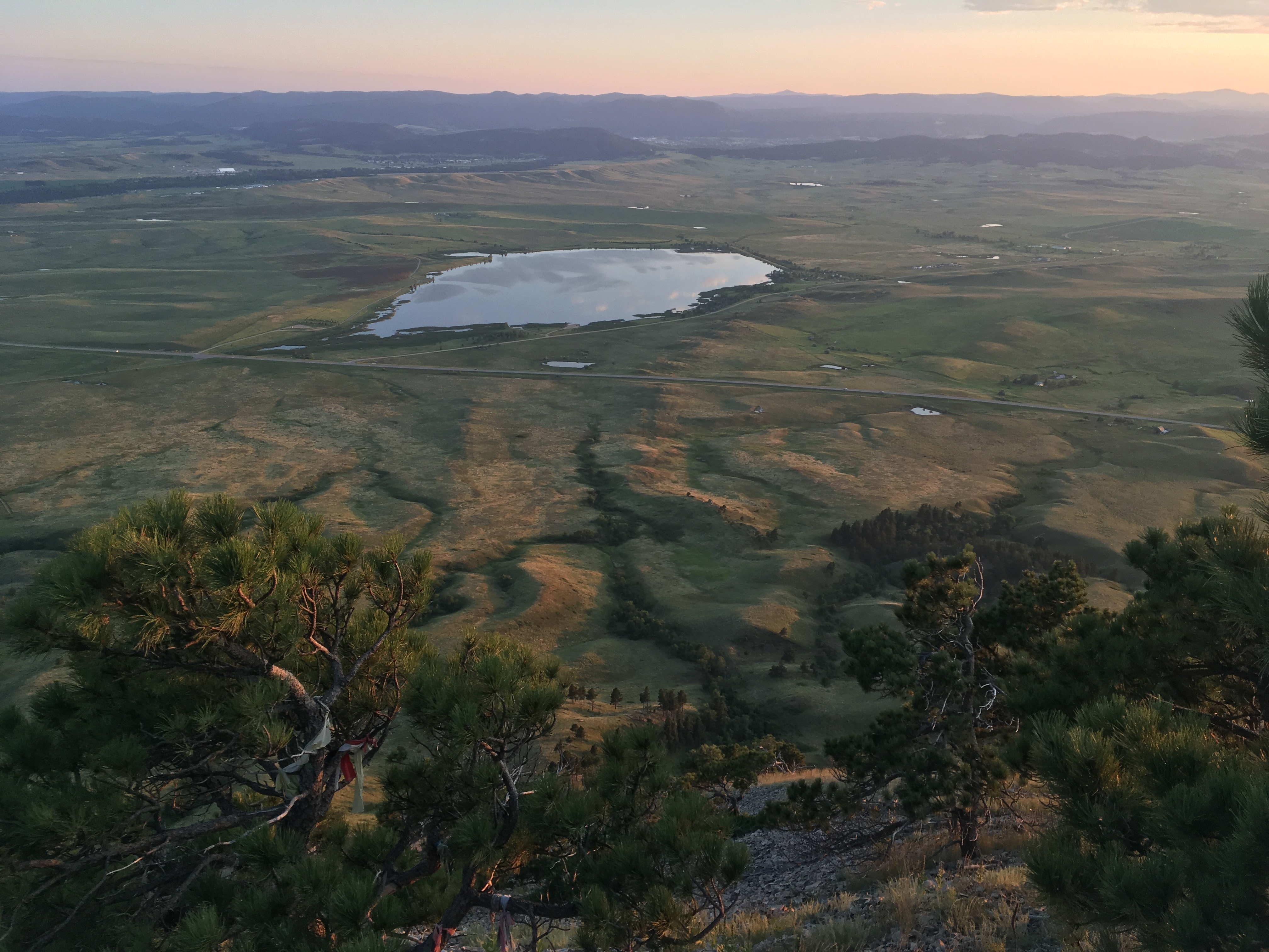
Bear Butte Reservoir, as seen from the summit of Bear Butte at sunset. Clay Bonnyman Evans photo.
Bear Butte: The Katahdin of the CET. Jutting more than 1,600 feet up from the surrounding plains, this last outpost of the western mountains–the next actual mountain directly to the east is in northern Vermont–is sacred to several Plains Indian tribes. Cheyenne, Lakota, and Hunkpapa people tie colorful cloth prayer bundles to junipers and trees along the steep, spectacular ascent, and the summit offers spectacular 360-degree views. You may see buffalo, deer, or elk on the grassy skirts far below.
Mount Rushmore: A half-mile detour on a well-marked trail and about 300 feet of climbing deliver hikers from the Black Elk Wilderness to this American icon. You may be shocked by the crowds after your solitude, but … there’s a cafeteria!

A half-mile side trail leads Centennial Trail hikers from the Black Elk Wilderness to Mount Rushmore National Memorial. Clay Bonnyman Evans photo.
Custer State Park: The trail cuts across some 70,000 acres of rolling plains and hills, offering a heart-soaring sight: Herds of American bison and lone bulls. Bison are much wilder than cattle, so keep your distance, but it’s an incredible experience to see these monarchs of the plains living as they did for tens of thousands of years before they were almost driven to extinction (though herd numbers are managed).
Sheridan Lake: If you are hiking in the summer heat, this quiet spot is a welcome place to get wet. For SOBOs, it comes before the trail’s most sustained and steepest ascent, reaching the 5,800-foot high point on the flanks of Mount Samelius.
Black Elk Wilderness: The nine-mile amble through the wilderness features cold, clear streams, soaring granite obelisks, and long views of distant peaks. Also, the admittedly un-wilderness-y side trip to Mount Rushmore. Not that you really need a cold Coke or beer at high noon on a blazing summer afternoon.
Water
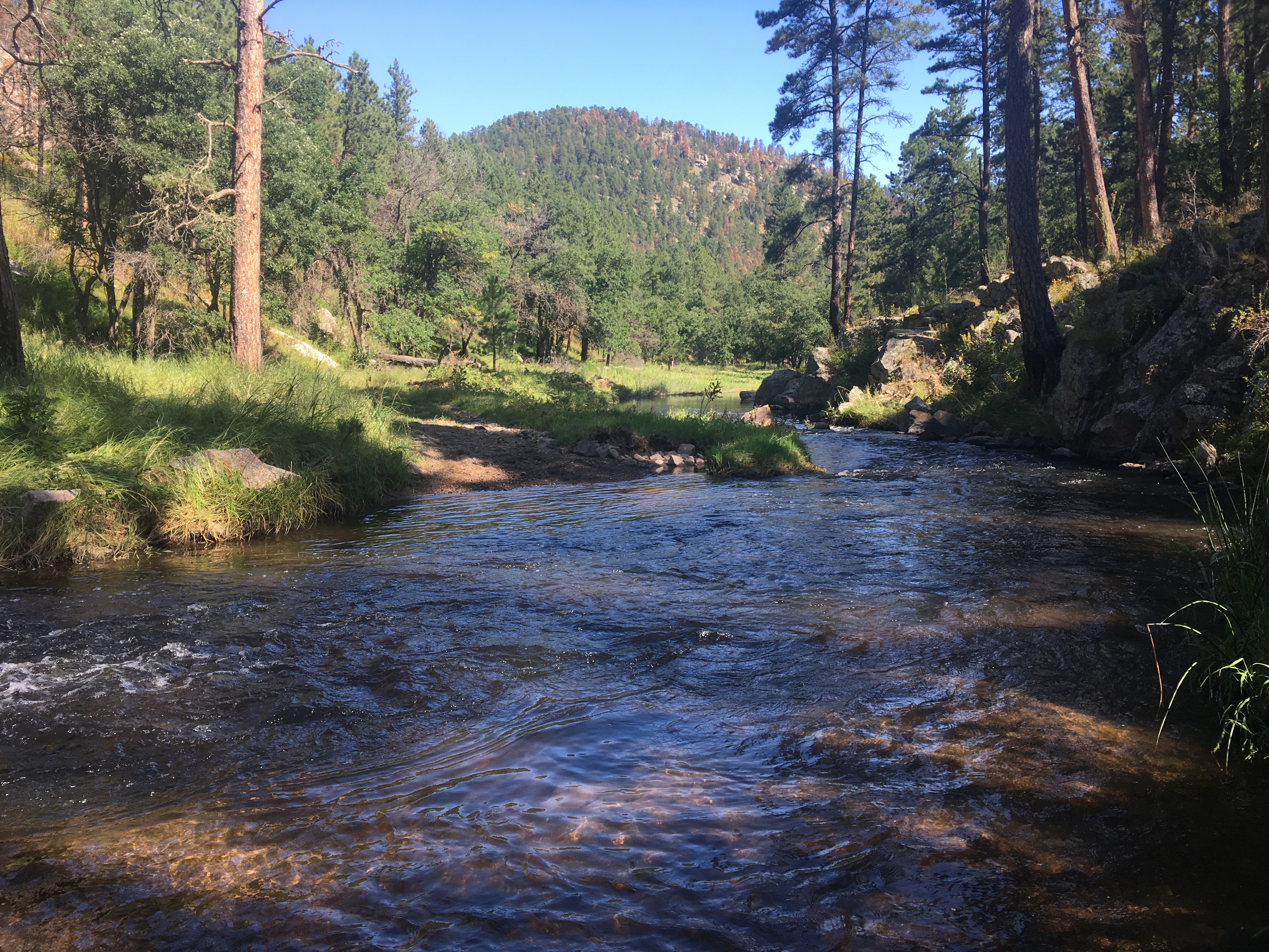
Water was plentiful on the Centennial Trail in 2019, but hikers should research water sources carefully before setting out. French Creek, shown here, was one of several streams requiring a thigh-deep ford in August 2019. Clay Bonnyman Evans.
Water is the key to the CET, and availability is dependent on recent weather patterns.
August 2019, for example, followed a wet spring and early summer, and water was plentiful all along the trail. Not only were all seasonal and reliable sources running well and lakes and reservoirs full, but also typically dry sources—even many wildcat sources—were flowing.
However, in 2018, when the guidebook authors section-hiked the trail, seasonal sources were frequently dry. Authors Cheryl Whetham and Jukka Huhtiniemi are locals; they maintain a Facebook group for the CET and post post semiregular water reports.
Resupply
The trail is short enough that it’s possible to thru-hike without a resupply.
However, it also passes two small towns that have restaurants and adequate resupply options, Merritt and Nemo. You can also hike about a half mile off the trail to reach Whispering Pines campground, where there is limited resupply (candy bars, sports drinks, canned tuna, beer, etc.). Snacks and drinks are available at the cafeteria and store at Mount Rushmore.
Fauna

Bison are a common site on the Centennial Trail in Custer State Park and Wind Cave National Park. This bull was lying in the middle of the trail early in the morning. Clay Bonnyman Evans photo.
Let’s talk about bison, aka buffalo, in Custer State Park and Wind Cave National Park. These are powerful, potentially aggressive animals; treat them as you would a bear and keep your distance. Be mindful of where you pitch a tent; look for bison sign–feces, matted grass where animals have bedded down—and make camp where there’s nothing a buffalo might have a hankering for at 2 a.m.; i.e., grass or water. I was grateful for having chosen a small hillock above a water source when, well after midnight, a hulking, grunting, growling bison bull—if there were such things as ogres, they’d sound like this—decided he needed a wee drink.
You can also expect to see:
-Bighorn sheep
-Mountain goats
-Elk
-Whitetail and mule deer
-Compact little red squirrels
-Turkey
-Raptors–bald and golden eagles, hawks, falcons and vultures
-Frogs and toads
-Snakes, including rattlesnakes; though common in the area, I didn’t see any.
-Cattle. Expect to see them.
Closing Thoughts

The Centennial Trail offers frequent, gorgeous views of wide-open Western landscapes. Clay Bonnyman Evans photo.
If you want a moderately challenging trail you can walk in a week or less, without a crowd, the Centennial Trail is a great choice. This would be an excellent hike for first-timers who want to see if long-distance hiking is for them.
That said, it’s not a casual hike; you’ve got to pay more attention than, say, on the well-blazed AT. Though generally well-marked, there are numerous places where I had to poke around a bit to determine which way to go.
Curiously, the trail has no fewer than five different styles of markers, both freestanding and nailed to trees. The one common feature is a silhouette of a (presumably bison) skull.
Occasionally, after miles of comfortingly regular markers, they inexplicably go AWOL. Meanwhile, in pastures and grasslands, many have been knocked down by cattle or bison who use them, literally, to scratch their big, dusty butts. In places the tread is invisible, or fainter than cow or bison trails, and the half-mile below Pactola Reservoir dam was like bushwhacking through a rain-drenched Southeast Asian jungle, a riot of dripping foliage rising hovering six or seven feet above the “trail.”
But with care, you won’t waste too much time toddling down stray cow- or bison-paths. After a few early mishaps that added irritating sideways miles to the day, the author adopted an attitude of almost weenie-like vigilance, tromping back to find the last marker at the first inkling of doubt.
But don’t let that, water worries, or the possibility of a night-time encounter with an ogre—bison; we meant bison—deter you. Uncrowded, eminently doable and crammed with fascinating sights and experiences from terminus to terminus, the Centennial Trail is a hidden gem tucked away in the Black Hills.

This website contains affiliate links, which means The Trek may receive a percentage of any product or service you purchase using the links in the articles or advertisements. The buyer pays the same price as they would otherwise, and your purchase helps to support The Trek's ongoing goal to serve you quality backpacking advice and information. Thanks for your support!
To learn more, please visit the About This Site page.

Comments 29
Great report! Thanks.
May be headed to the Black Hills soon and will try to tramp some of these miles.
It’s a great trail; I hope you do!
Thank you for the report – great information!
You’re welcome. I’m really glad I got to do this one; well worth it.
Love these articles about the smaller thru Hikes, my only question is how can we encourage Guthook Guides to offer these trails?
Great Write-up on this Trail. Been searching for my next week long hike and this just made the top of my list. The chance of seeing an Ogre sold it!!
Thanks for the information and I really enjoyed your writing style. Will follow your post from now on.
You have an extremely good chance of seeing a bison/ogre in Custer State Park or Wind Cave National Park. They are incredible creatures, and make the hike worth it all on their own.
~Pony
In the summer of 2020, I plan to pedal a huge, counter-clockwise loop through South Dakota. I only have time for a day hike on the Centennial Trail from the Boxelder Trail head. So which is prettier . . . going north or south? Thanks. I prefer an answer via e-mail.
John
I plan to hike the Centennial Trail May 2020. Thanks for your article! It’s hard to find good information on this trail, so I really appreciate reading about your hike. Would love to hear more details about the logistics.
I’m a local resident and long distance thru hiker. If anyone needs assistance coming to the Black Hills , go ahead and give me a ring. I can help shuttle you around and info on the area. (719) 351-5270.
Hi Jason, I am considering hiking the trail in June of 2020. I may get in contact with you if the offer is still open. Thanks!
Anytime. I can help with any shuttles on a Sunday.
Mav–we’re SOBO from Bear Butte Educational Center to Highland Creek TH (Bringing a dog). Wondering if Elk Creek will have water 6/4-6/8 timeframe? We’ve heard we need to carry water from Alkali to Dalton, but hoping Elk Creek will have water. On the flip side, do we need to worry about crossing Elk Creek? Any other hints/tips are welcome! Can we leave a car at Highland Creek TH for 8 days?
Hi, Sassy. I
‘m the writer of the above piece.
If you use Facebook, sign up for the “Hiking Centennial Trail” page. The owners of that page are the authors of the CT guidebook that you can buy, and they make a point to do water reports. It all depends on what the winter has been like, how dry the spring and summer are, etc. But they are a great resource for that information.
~Pony
As of 26 May 2020, there is plenty of water at Elk Creek. Currently shin high. You will have to cross it several times.
Hi, Jason,
I’m possibly cancelling starting my AT SOBO thru-hike (was going to start in about 1 month), and would like to perhaps take on the Centennial Trail beauty and challenge in the coming few weeks on a NOBO thru-hike. Your assistance would be great, if possible! I just left you a vm.
Thanks!
Steve
Planning on doing the Centennial this summer. There’s a trail closure though and the rangers say there’s not an easy way around on foot :/
Trying to figure out best time to go and how to bypass the section they’re blasting. Also looking for an end to end gpx track for the trail.
Getting prepped to do the CET, just making sure that you are still able to shuttle just in case? at any point or just at the beginning/ends? I’m so afraid of not being able to make all the 123 miles… just trying to cover all my bases! thank you!
Thank you for the great information! I did a section of the trail from Alkali Creek to Nemo in the Sept of 2019. Hoping to get back there in 2020 to finish it.
what is the best date range for a south bound start??
if that was mentioned in your article, i missed it
thanks
bob
Hi, Bob. Thanks for writing.
The date range is pretty variable, all depending on the weather.
Presuming you aren’t interested in a winter hike, your best bet is probably June-October.
Keep in mind that water is a critical factor, and in a lower-snow year, some sources are likely to be dried up by late summer. In addition, as with anywhere in the west over 5,000 feet, you *can* get wintry weather into June.
Although at lower elevations it was extremely hot when I hiked in late August, I didn’t find the heat in the Black Hills oppressive at all. The southern reaches of the trail are pretty exposed, but you are often in the trees for much of the trail.
If I were to do it again, I’d probably shoot for June or early July, to better my chances with water. Last summer was extraordinarily easy as far as H2O goes, but that’s not always the case!
Feel free to email me at claybonnyman (at) gmail if you have any further questions.
~Pony
Thanks for the excellent write-up. I just finished the Colorado Trail this summer and for whatever reason I tend to gravitate toward this lesser known 100-200 mile trails. This looks like an absolute gem. Hopefully next year. I am also curious about bikepacking this trail over a few days.
Thank you; it’s a great mid-length trail, for sure.
Since you’ve hiked the CT, I can compare the Centennial Trail to the foothills parts of the CT, along the Arkansas Valley, the first 100 miles (minus the higher passes). Well worth doing.
Hope you get to hike it!
~Pony
I just finished the trail on May 22, 2020. A few things to note:
1. Transportation to the trailhead when parking at one end can be done through Prairie Hills Transit. Talk to Lisa in the Sturgis Office as she assisted me with a pick up at Ft. Meade and drop off at Norbeck Dam.
2. Do not bank on intermittent streams for water.
3. Fill all water bottles & bladders for your hikes through the Northern sections from Dalton Lake to Elk Creek and from Elk Creek to Alkaline Creek. I strongly encourage 5 liters of hydration capacity. You will go long distances between fill ups. Make sure you have a good water filtration system or enough potable aqua tablets.
4. Do not expect to find good camping spots next to water sources. Be prepared to haul water to ridge tops for better camping accommodations. There is a reslly good reason these are called the Black Hills and as such, nice flat tent sites are a premium.
5. What goes down, must go up.
6. The National Geographic maps are somewhat out of date. They are still the best option. Downloading them to the Avenza Maps app is a wise decision with GPS tracking and then comparing them with the 2018 Centennial Trail book edition give greater clarity on the trail changes. All Trails does not have the complete Cemtennial Trail but only a few sections.
7. Two great resupply caches and rest options are
Rustic Ridge Guest Cabins near the Samelius Trailhead – owners Jim & Crystal are fantastic. This is a great place to hold up for a night. Also the Nemo Guest Ranch near the South Boxelder Creek Traihead – Owners Troy and Willie are great and accommodating people.
8. Take time to smell the roses. This is not a race and there is much to see and celebrate along the way. Recapture your wonder at the majesty of God’s creation!
9. A whistle can be effective for diverting stampeding buffalo. I wish I did not know this, but it was a necessary option in Custer State Park as I was outnumbered about 50 to 1. That was a crazy experience.
10. Be ready for multiple wet creek fords at French Creek, Iron Creek, and Elk Creek. Most were followed by rather strenuous inclines so be prepared and take care of your feet!
I am hiking this late May 2021. There doesn’t appear to be any camping along the trail in Custer State Park until you get to French creek area, unless I am missing it on the maps. thanks for the great post.
Hi, Amy.
Stealth camping is available throughout Custer State Park, with no restrictions that I’m aware of. You should double check that, of course, but I stealth camped in the park.
Have fun; it’s a great trail.
~Pony
Hi, Amy.
Stealth camping is available throughout Custer State Park, with no restrictions that I’m aware of. You should double check that, of course, but I stealth camped in the park.
Have fun; it’s a great trail.
~Pony
Great article with lots of useful info. Tackling this trail in about two weeks so this was very helpful. Thanks again.
You are welcome! It’s a fun trail, really great.