 ">
">
Trekking in the Shadow of Kyrgyzstan’s Peak Lenin, Day 1
We have been trekking in Kyrgyzstan for 23 days now. We have only four days left, and we have saved the biggest challenge and hopefully the best scenery for last. For our final trek, we will be hiking around Peak Lenin, Kyrgyzstan’s highest peak at 23,405 feet. They say that Peak Lenin is one of the easiest 7,000+ meter peaks to summit, but we have no interest in going that high.
Instead, we will be hiking from Peak Lenin Base Camp to Camp One, where we will spend the night and then attempt to summit 17,000-foot Peak Yuhina, which is a training ground for the mountaineers and climbers who flock here to do the big peak. On day three, we’ll head back down to base camp and then have a final day doing one last day hike in the Peak Lenin area. We have been staring at this enormous white wall since we arrived in Sary Mogul a week ago, and we are all eager to see what hiking in those mountains will be like.
After breakfast and packing up at our Sary Mogul guesthouse, we load into two cars to drive to Peak Lenin Base Camp at Tulparkol Lake. We drive through the village of Sary Mogul, which is a lot bigger than we first thought, and then pick up a dirt road that takes us straight across the grassy plain toward the mighty peak.

The white mountain chain with its base of soft, rolling green foothills gets more and more impressive the closer we get, and Matt keeps asking the driver to stop so he can get photos along the way. The driver is kind enough to oblige us several times during the one-hour drive. We’re almost ready to call it quits for the day when we arrive at base camp because just the drive alone has been so spectacular.


On the trail out of base camp, Timu and our mountaineering guide Musa are able to pick up a horse porter to carry our gear (sleeping bags, sleeping clothes, toothbrush, etc.), their gear, and the food we will need for the next few days. The horseman ties the two enormous, stuffed packs together, draping them sideways over the horse. We are happy that they won’t have to carry the heavy packs the 13.5-kilometer hike and 4,000-foot ascent that we have in store for us today.


Shortly thereafter, the trail descends to a footbridge that crosses a raging, glacial-fed river. The water is dark brown and full of silt from the glacial runoff. We cross the bridge and continue uphill until we reach a big, grassy plain with a series of well-rutted trails leading through it and snow-capped peaks all around. The mountains to our left are completely covered in chunky, white glaciers that make us all hungry for a nice scoop of ice cream on this warm, sunny day.


Most of these peaks we can see now are well over 20,000 feet, but it feels like they are right in our face even though we are only hiking around 11,000 feet. We keep asking ourselves the same question over and over again as we make our way up the trail and closer to the peaks. How can the summits of these mountains be some 10,000+ feet higher than where we are presently?
The only other mountain that we can think of that looks so big and so impressive from a hiking trail is Mount Rainier, which we got to know very well while backpacking the Wonderland Trail. These mountains are so big that it appears like we have about three Mount Rainiers lined up all in a row. It’s an incredible scene, and, with alpine landscapes like this, we wonder how Kyrgyzstan has stayed under the radar for this long.


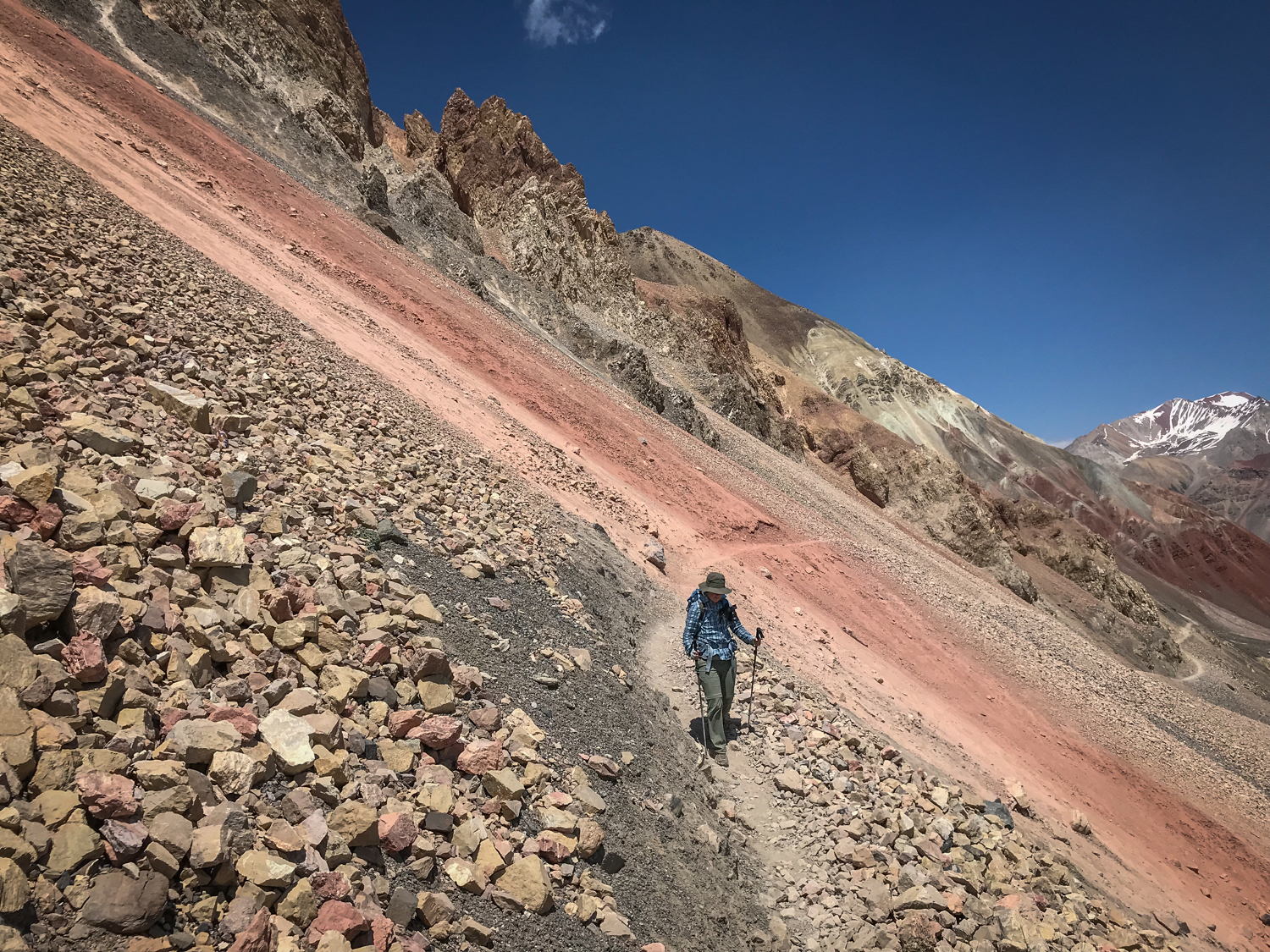
We break for a quick snack at the end of the long, flat section. From here, we have a steep climb that takes us to the base of Travelers Pass. It’s a long way up from where we are at the bottom to the top of the pass, and we can see a series of switchbacks zigzagging their way up to the top through the gray and pink rock.


This section of the trail is a little bit of choose your own adventure, depending on how steep or how long you want to hike. Our horseman takes the long route, but his horse has some trouble with a snow patch and stumbles awkwardly. Luckily, they both appear to be alright and continue on. The footing doesn’t look too bad on the slope, so we take the medium-steep route. The steepest routes seem to be reserved for climbers on their way down from summiting Peak Lenin.


It takes a lot of effort, but we finally make it to the top of Travelers Pass, the last of our little group to arrive. We can see everyone else already about 100 feet below us in a grassy spot out of the wind. Timu and Musa are preparing lunch, while Rob and Amy are chatting with some hikers. (They turn out to be a pair of French hikers who plan on summiting Peak Lenin and then skiing back down to Camp One—yikes!) It’s not every day that you stand at 4,150 meters (13,615 feet), so we take our time taking photographs and enjoying the incredible scene before joining everyone down below.


It’s hard to describe how impressive the view in front of us is, but I will give it a try. In front of us, a long row of glacier-covered peaks dominates the scene, and, just to our right and left, rainbow-colored mountains add to the drama of the landscape. There is a steep drop-off just below us, and, at the bottom, a long, rock-covered glacier fills the entire valley, a frozen river of ice, anchoring the entire scene. We have hiked in a lot of places all over the world, and this particular mountainscape has to be one of the grandest we have ever seen.


There are two other groups of hikers hanging out here, and I start up conversations with them, hoping to get some intel on what the trail will be like ahead. Unfortunately, I strike out. Both groups are day-tripping from base camp and using Travelers Pass as their turn-around point. I can only see the very beginning of the trail snaking down the valley wall, so I guess the rest of the hike will be a surprise. Fun!
After lunch, we start heading down. We descend via steep switchbacks for about 15 minutes before the trail flattens out, passing directly below Travelers Pass—that’s why we couldn’t see it. We hike for several kilometers contouring the colorful moraine valley on a narrow ledge high above the glacier. The terrain varies between loose rock, slippery scree, and soft sand, keeping us on our toes as we make our way walking for several kilometers through this stunning landscape to the far end of the valley.


For the most part, the trail is wide enough to feel secure, but every now and then we are reminded of how dangerous an unfortunate misstep could be…

The dark gray “rock” below us is actually glacier covered in rock and soil.


Just before reaching the end, the trail drops down to a river, where there are at least a dozen horsemen gathered together. We aren’t exactly sure what is going on, but, as soon as we arrive, all of them come over to us, jockeying for position with one another, trying to earn a little som by taking us across the river.

Musa grabs my poles and Amy’s poles before we get a chance to fold them up. I take my bag off, put my camera away, and hand my bag over to Timu, hoping he will take it across for me. Amy hops onto a horse with a little boy at the reigns and takes off. I’m next, but, as the horsemen try to wedge in front of each other in this narrow space on the riverbank, one of them steps on Amy’s and my poles that Musa, unfortunately, has put on the ground. Luckily, my poles are OK, but Amy’s are made of carbon fiber and are more delicate. The weight of the horse snaps them in two, rendering them useless and upsetting all of us.

The whole scene is quite chaotic, and now Musa wants me to hop on the back of the horse he is on while everyone is yelling at each other over the broken poles. Eventually, we all make it across the river on horseback, but the careless mishap casts a dark shadow over the rest of the day.

From the river, we climb steeply up to a stark, rocky plateau. The trail is fairly flat here, and we make good time heading to Camp One. We have one last obstacle before being done for the day. The trail drops down to a river crossing, and it doesn’t look too bad from above. There are many braids in the river, and each little section is simple enough to hop across.


There is some confusion as to which way to go, and we all jump the little streams while Musa heads up the riverbank. There is a short trail up a snowbank to the camp, so we aren’t sure why he is going upstream, but I see him gesturing wildly to follow him. I point to the other trail, and he gestures at his waist, which I take to mean we’ll run into deep snow if we continue.
Timu, Amy, Matt, and I turn around, but Rob is already across and heading up the snowbank. All looks good until he gets to the very top when he suddenly postholes up to his waist! He’s a good sport about it, especially considering we are all laughing at him from across the river. He digs himself out, only to posthole again! This time we get the picture.


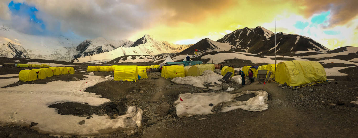
We all meet up at Camp One, a seasonal tent settlement for climbers making their way up to Peak Lenin. This particular camp is run by Ak-Sai Travel, and there are about 50 bright yellow two-person tents set up, side-by-side and organized into little lanes.


Most of the tents we pass are already occupied by climbers who are in various states of undress with their gear strewn about their temporary tiny homes. Laundry hangs from every spot possible, and huge snow boots/crampons decorate doorsteps, as if they were waiting for the arrival of St. Nick to fill them with treats. It feels a little bit like a refugee camp up here in the mountains.


Musa and Timu show us to our tents, which are numbered 30 and 31. The tents are much bigger than what we are accustomed to. They have thick foam mattresses inside and a little wooden deck in an antechamber. You can even stand upright in them, which could be a blessing or a curse depending on how cold it gets up here tonight at 14,500 feet. That’s a lot of air to warm up! We take a little time to get settled in our tent, airing out our sleeping bags, and changing into warmer pants and our dry, long underwear tops.


After a bit of a rest, we make our way to the dining tent for some tea and coffee. Along the way, we get a better sense of all the amenities on offer up here at Ak-sai Camp. There is a station of four sinks with mirrors with cold running water available from 8 a.m. to 8 p.m.


There are four outhouses, three of which are labeled for men and one for women, which roughly corresponds to the population we see here in camp. The outhouses are stocked with plenty of toilet paper and even cans of air freshener, which seems a little pointless given the circumstances, but is a nice touch. There is a line of tents that serve as the administrative hub of the camp. There are huge solar panels and signs labeled Office and Doctor.


We pass a little lounge area with benches made out of wooden crates where climbers are on their phones using the Wi-Fi offered in camp for $5 and hour. In the bar tent, you can buy soda, beer, wine, and vodka at roughly American prices, which isn’t too bad given our location. A shipping crate has been converted into a kitchen to feed the camp residents, and everyone eats meals in large, communal dining tents. There is even a sauna that can be rented by up to four people for $25 an hour.


It’s quite a scene up here. As mere hikers, we feel a little bit out of our element, and we are definitely low man on the totem pole. It’s still fun for us to get a sense of what the Big Leagues are like. And, hey, we walked up here, too!
We make our way to one of the dining tents, where we grab a space at a long table that is stocked with coffees, teas, cookies, crackers, candies, and jams/jellies at all hours of the day.


There is a trio of Russian climbers eating here who have just made their way down from Camp Three after summiting Peak Lenin the day before. They look exhausted, and the skin on their faces is beet red, hard and dry from so much exposure on the snow. One of them even has a black nose, a telltale sign of frostbite. They eat in silence, occasionally checking out the damage to their skin on their phones. Climbers are definitely a different breed.
After tea, we relax for a while in our tent before returning to the dining tent for dinner. It’s chocked full of people now, and we find space next to an older couple from Poland and some Sherpas from Nepal who spend the summers here on Peak Lenin while it is the off-season in their own country. Dinner is a plate full of the tastiest plav we have had yet and a generous portion of marinated cucumber salad. We are pleasantly surprised by how delicious it all is, and we all clean our plates.
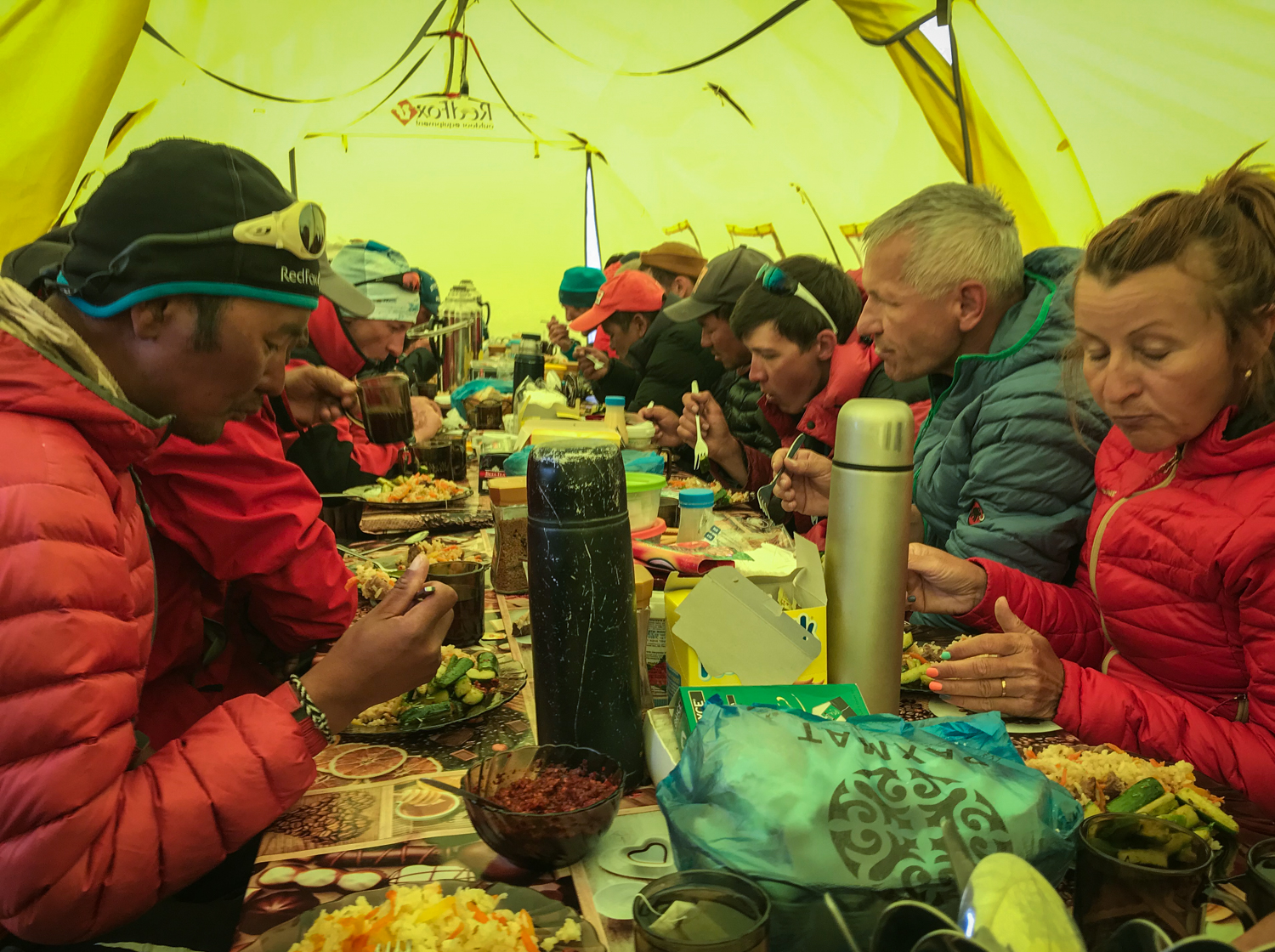

Over dinner, the Sherpa tells us that he has summited Everest 15 times (!), so he isn’t particularly impressed when I tell him that we did the Annapurna Circuit back in 2011. Peak Lenin must be child’s play for him. The Polish couple is here without a guide, and they will be leaving at 3 in the morning to begin their summit attempt. We wish them well as they excuse themselves from the table to head to bed.
After dinner, we spend some time trying to collect enough drinking water for our big climb up to Peak Yahuna tomorrow. There is plenty of hot water available, but we need to cool it down a bit before pouring it into our plastic bottles. We pour the hot water from the thermoses into coffee cups and let it cool as we type up our trail notes for the day. Rob and Amy pitch in by filling their metal drinking bottles and sinking them in the snow. The sun is just about to set, and beautiful golden light shines on the camp and all the peaks surrounding us. What a scene!


Once we’ve collected enough water, it’s off to bed for everyone. The temperature outside is rapidly cooling down, and we are all eager to climb into our cozy sleeping bags for the night.

This website contains affiliate links, which means The Trek may receive a percentage of any product or service you purchase using the links in the articles or advertisements. The buyer pays the same price as they would otherwise, and your purchase helps to support The Trek's ongoing goal to serve you quality backpacking advice and information. Thanks for your support!
To learn more, please visit the About This Site page.
