 ">
">
Vancouver Island Trail: Recap (and Tips!)
It’s spring in Victoria on southern Vancouver Island. The wind is losing its chilly bite, the daffodils are blooming, and the cherry blossoms are bursting. The greenery all around fills my nostrils and I remember that the world has a smell, as it slowly wakes up from its wet wintery slumber.

Spring! Crocuses!
Last summer, I decided to walk out my door and keep walking until I reached the northern tip of the island – 800km/500mi away. My first thru-hike: it was exhilarating, challenging, terrifying, and altogether a life-changing experience.
As the season of new beginnings arrives, closing the door on the cycle that came before, I want to reflect on some takeaways from my hike of this little-known trail, and recap my experience in a bite-size mini-guide for those interested but who aren’t bothered to read back on all my blogs 🙂
The Recap: Section-by-Section
You can see my technical and historical breakdown of each section here. But facts aren’t everything – a trail is so much more than its distance and elevation stats. Which is why I also want to provide a window into my personal experience of each of the many diverse sections of the trail.
The Bike Trails:

Straight, flat, fast
It began with two long days of flat bike trails, through the bustling city of Victoria, through the hills and farmlands, and up the river to Lake Cowichan. The excitement, the easy walking, and the lack of camp spots propelled me to log my longest day of the whole hike at 44kms. That first night, I freaked myself out by thinking the mooing of some cows nearby was the roaring of a bear. Huddled in sweat in my tent, I survived to tell the tale. It was just a taste of the mental battle I’d be facing with fear throughout my entire hike.
The Backroads:

Crossing a cutblock
From Lake Cowichan to Port Alberni it was a mixed bag of highway shoulders, logging roads, new and overgrown trail, and old mossy railway grade, with two belly-button-level river fords sprinkled in for good measure. Sometimes I was following a two-track through dense shadowy second growth, getting soaked from flapping ferns; other times I was picking my way across the wooden debris of a new cutblock, studded with fresh stumps. This is the reality of travelling through the patchwork industrial forests that are not fortunate enough to be protected in parks. I saw more trucks than foot travellers: indeed I was the only one. My first taste of solitude in these sad forests left me uneasy, wondering if I had the fortitude to push through my fears going forward. My spirits lifted when I met some kind trail volunteers who opened their home to me in town.
The Beauforts:

Looking down on Beaufort Lake from Mt Stubbs
I spent the better part of my five days in the Beaufort range on snow. With 2022 being a high snow year, the traverse was still blanketed, even in mid July. Navigation skills were put to the test as markers were buried or non-existent, and the higher elevations shrouded themselves in fog. It was a pure and silent world (save for the birds and owls). I didn’t see another human the entire time. When the clouds did clear there were views for miles. It was a lot to take on for my first time snow-hiking and my first time route-finding – it was scary, but so meaningful and rewarding, and I managed to get through it in one piece.
Strathcona:
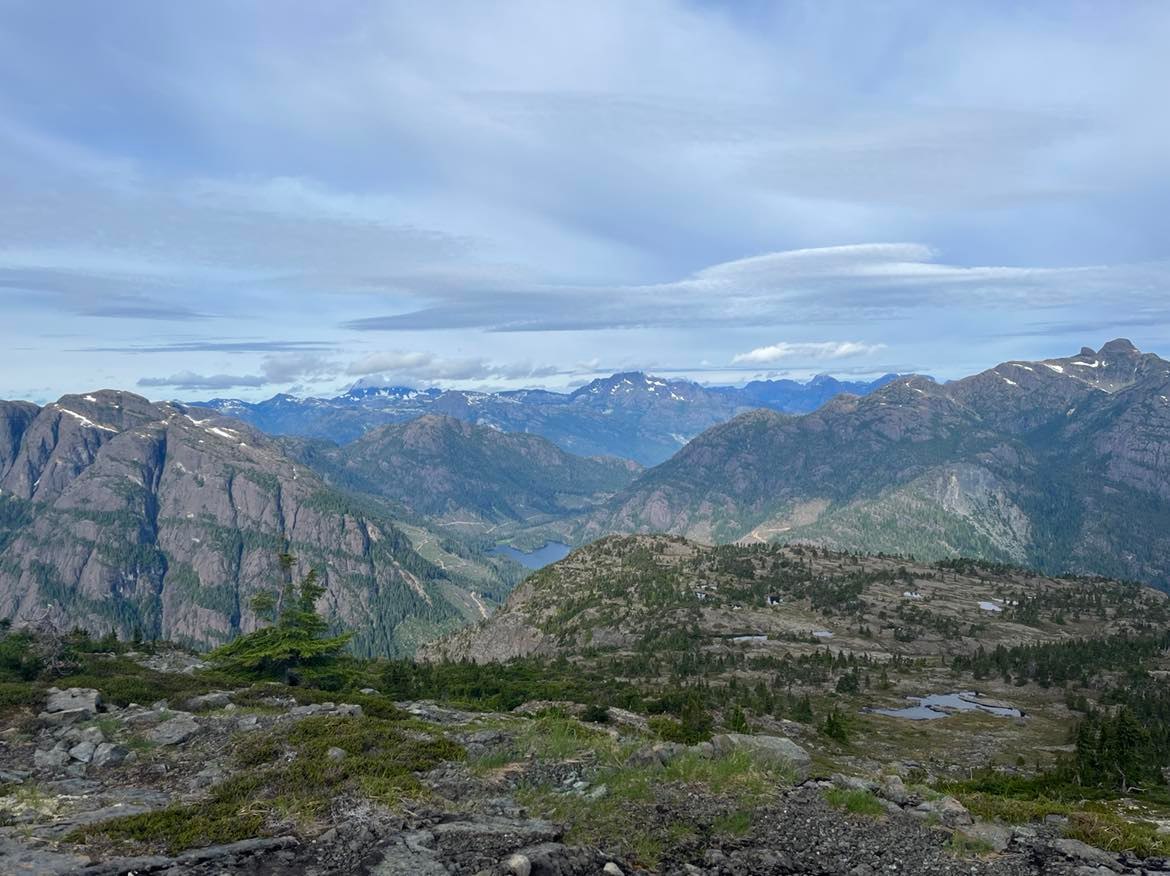
View from Mt Jutland
Due to the lingering snow in July, I skipped ~100kms of mountains in and around Strathcona Provincial Park and circled back to them at the end in August. I’m glad I did – by the time I climbed out of Cumberland and up into the heather meadows of the Forbidden Plateau, the snow was gone, the wildflowers were out, and the weather was clear. It was the most vertical section of trail – I climbed (and descended) at least 1000m/3300ft a day, four days in a row. I took the chance to side-quest and bag Mt Albert Edward, the second tallest mountain on the island (which I highly recommend!). I cried tears of elation the next day on top of Jutland mountain, taking in the beauty of the Van Isle ranges. I skinny dipped in the aptly-named Pearl Lake and stayed in the secret cabin on its shores. Unfortunately after that, on the steep slopes of Mt Adrian, I took a wrong turn and found myself in a vertical gully, where I had no safer choice but to climb down. Being too spooked to climb back up and find the trail markers again, I bailed down to a road at the bottom of the mountain. I came back later on a day trip to finish the kilometers I missed, including the beautiful mountains of Beadnell and Lupin.
The River Valleys:
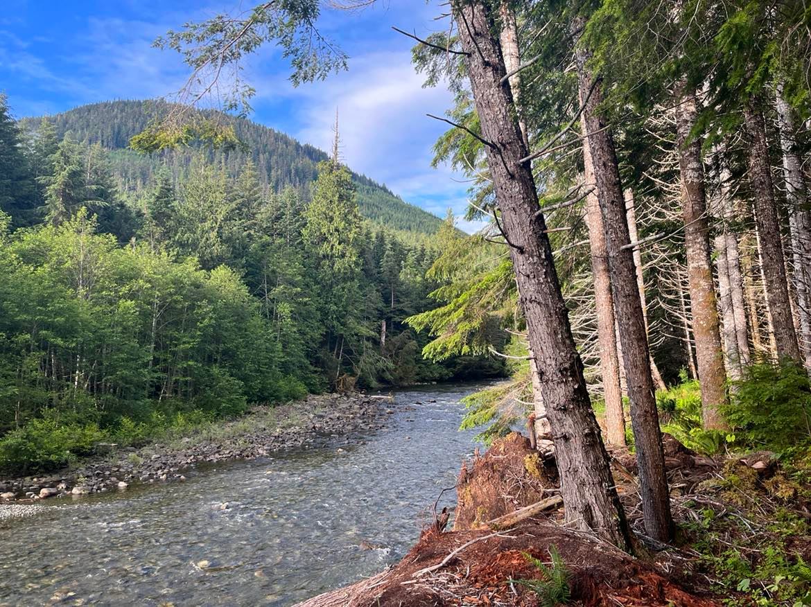
Salmon River
Crossing the Strathcona Dam, I followed deteriorating logging roads deeper into the heart of the island, where few ever set foot. I hiked on, in spite of bowel issues and a worsening pain in my right ankle. I followed the rushing Salmon River, and then the wide White River, marvelling at the old growth in the soft valley soil, and braving the gnarly blowdown. I bloodied myself with cuts and scrapes in my frustrated efforts to force myself through the dense forest. I saw elk, and then I saw my first bear, and then I couldn’t stop seeing bears. I was so scared of them, but they just left me alone and continued about their berry-eating business. I had a magical experience at Schoen lake at golden hour. When I reached the town of Woss, I called my mom to pick me up and I stayed at her place for a week, to heal my hurting ankle.
The Railway:

Nimpkish Lake / Nimpkish Valley
Ankle on the mend, I was thankful for the flatness of the railway grade that gently whisked me through the next section. Although, it was slow going, as the grade is made of pebble to fist-sized gravel, which increased the ankle rolling risk significantly. It was hot: 30+ degrees C. I followed the shore of the long and windy Nimpkish lake and found a beautiful secret beach at its northern end for an afternoon of chilling. The next day I breathed in the salty coastal breeze, in the town of Port McNeill.
The Coast:

Sunrise at Shuttleworth Bight
After a day of rest at Cluxewe Resort, I walked the long beach to the next town, foregoing the parallel but rougher forest trail. The tide was out and the beachcombing was fantastic. I witnessed bears and fishermen coexisting, both on the hunt for salmon at the sandy river mouths, where salt water meets fresh. In Port Hardy I grabbed a hostel room and resupplied, preparing for my 7-day stretch to the end. 40kms of logging roads through rolling cutblocks took me to the start of the North Coast Trail, a popular hike that is more commonly accessed by chartered boat. For the first time I shared the trail with fellow hikers, and enjoyed the fleeting camaraderie. Beautiful beaches, muddy forest trails, and two cable car river crossings saw me to the Cape Scott Lighthouse: the northern terminus.
Best Bits
Diversity: One of the best things about this trail is that it really showcases a huge diversity of terrain in such a short length. You get a city tour, dry garry oak bluffs, and rolling farmlands. Lush river valleys, old growth trees, hidden lakes. The alpine, with its unique flora and fauna and jagged geography. The coast, with its salt, sand, mud, and marine life. Where else can you experience so intimately the many faces of the Pacific northwest?
Solitude: If you’re looking for a long distance hike that’s less busy, the VIT takes the cake for achieving that alone-in-the-wilderness experience. I didn’t see any other backpackers, except for in the 2 provincial parks, which constituted only a few days out of 36 hiking days.
Wildlife and Nature:

Bear on the beach
On top of the beautiful ecosystems you travel through, there is a great chance you’ll get to see cool wildlife up close too. I saw countless bears, deer, some elk, a cougar, and even whales and otters on my trip. Indeed, Van Isle has the highest concentration of both black bears and cougars in the world. There’s also the unique coastal wolf, whose tracks I found on a sandy beach. That being said, it’s important to be smart about food storage, especially in parks and other high-traffic areas!
Best Sections: In my opinion, the most worthwhile section hikes would be the mountains in and around Strathcona Park, and the coastal section including the North Coast Trail. They showcase the best of the island alpine and the coastal ecosystems respectively. But they are also challenging, in their own ways; Strathcona for its elevation profile and route finding once outside the park, and the coast, for its mud and oftentimes foul weather.
Most Challenging Bits
Solitude: Some people seek it, others avoid it. If you don’t start out with a group, you’re unlikely to have a very social experience on trail. As in: there’s seriously no one else out there. So if you are prone to loneliness and prefer the company of others, this might be a challenge.
Route-finding:
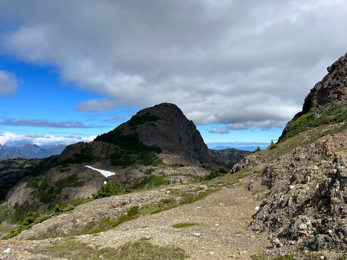
Route finding on Mt Adrian
The two high-elevation sections of trail, the Beaufort Range traverse and the mountains around Strathcona Park, can be tricky in terms of navigation – especially if you’re up earlier in the season and/or snow is lingering. When I was in the Beauforts, I mostly relied on my GPS, as snow and fog obscured many markers, and there was a stretch with no markers where I had to use my judgment to follow the height of the land. Around Strathcona, I found myself in a potentially dangerous situation when I accidentally got off route and into a vertical gully. It’s super important to keep your wits about you when in the mountains – especially if you’re not familiar with the area. Often the official route is the only safe way from one point to the next, narrowly avoiding hazardous cliffs, gulleys, or scree slopes.
Roads and Rails: Because the trail was designed to incorporate existing infrastructure as much as possible, it frequently makes use of logging roads (active and inactive), as well as old railway grades – sometimes for long stretches. You might find yourself on flat monotonous ground for multiple days in some places. This can get repetitive after a while, with the tunnel effect of the surrounding forest providing little variation. Although there are always interesting things to break up the day – like finding an abandoned railway car, crossing a trestle bridge, or passing car campers by a nice lake – there are some sections that are definitely not as wow-inducing every step of the way as other sections are.
Tips for Future Hikers
Weather Window:

This is the summit of Mt Apps when you’re too early!
The two higher elevation mountainous sections, the Beauforts and Strathcona, can be snow covered until the end of June, and snow can begin to fall again around the month of October. A thru-hike might take a month (fast) to six weeks (slower), which can easily fit into the window of July-September. The best month to hike would probably be August, as by then the snow is mostly gone in the higher elevations, precipitation is low and it is warm and dry. (However, campfire bans are common around this time to prevent wildfires). Coastal trails are also less muddy. Some seasonal water sources might be low or dry, but in general, water is ubiquitous throughout the trail and you usually have a chance to fill up a few times a day.
Resupply: A cool thing about the VIT is that it goes straight through towns at reasonable intervals, so it’s easy to hit up a grocery store every 3-6 days (depending on your speed and the section) for a good resupply. Towns will also have accommodation and entertainment options if you desire to linger a little longer – which you might want to, if you’re visiting from off-island, and wanting to be more of a tourist. However, the town of Woss only has an expensive gas station and a motel restaurant, so you might want to send a package to the post office there. As well, the stretch between Cumberland and Woss is quite long, but split in half by highway 28 – so hitching to the nearby town of Campbell River to resupply might be a good idea there.
Get in Touch: I would highly recommend prospective thru-hikers get in touch with the trail association. The people behind the trail have such a passion for their vision and love to know that their work is being appreciated by those who use the trail. During my hike, I was in contact with one of the board members and was able to receive up to date information about upcoming conditions, which was super useful in planning ahead. This new trail is still being fine-tuned, and the people with the insider knowledge and the best tips and tricks are those actively working behind the scenes. Besides, all the volunteers are such wonderful and welcoming people who want to see this trail grow and provide a positive experience for its users!
Finally:
As the summer of 2023 approaches, backpackers everywhere are pouring over maps, taking stock of gear, and preparing to go out on ambitious adventures. I write now to plant the seed of my little local trail in the collective consciousness, in the hopes that others might also experience the joy of hiking it.
That’s all for now. But.. stay tuned to this blog to hear about my next adventure!

This website contains affiliate links, which means The Trek may receive a percentage of any product or service you purchase using the links in the articles or advertisements. The buyer pays the same price as they would otherwise, and your purchase helps to support The Trek's ongoing goal to serve you quality backpacking advice and information. Thanks for your support!
To learn more, please visit the About This Site page.
