 ">
">
Via Dinarica: The BEST Thru-Hike You’ve Never Heard Of
The Via Dinarica is a network of long-distance hiking trails through the Dinaric Alps in the Balkans of Southeastern Europe. There are three trails: the White Trail, the Blue Trail, and the Green Trail. The White Trail is the most established, while the other two are more concept than reality. This trail profile focuses on the White Trail, which includes some of the highest peaks in Slovenia, Croatia, Bosnia and Herzegovina, Montenegro, and Albania.
The Via Dinarica Project started in 2010 with help from USAID, UNDP BiH, and AICS. Only the Bosnia and Herzegovina section is “officially” completed. However, My partner and I hiked the trail in its entirety from Razdrto, Slovenia to Valbona, Albania over the course of 60 days in 2021.
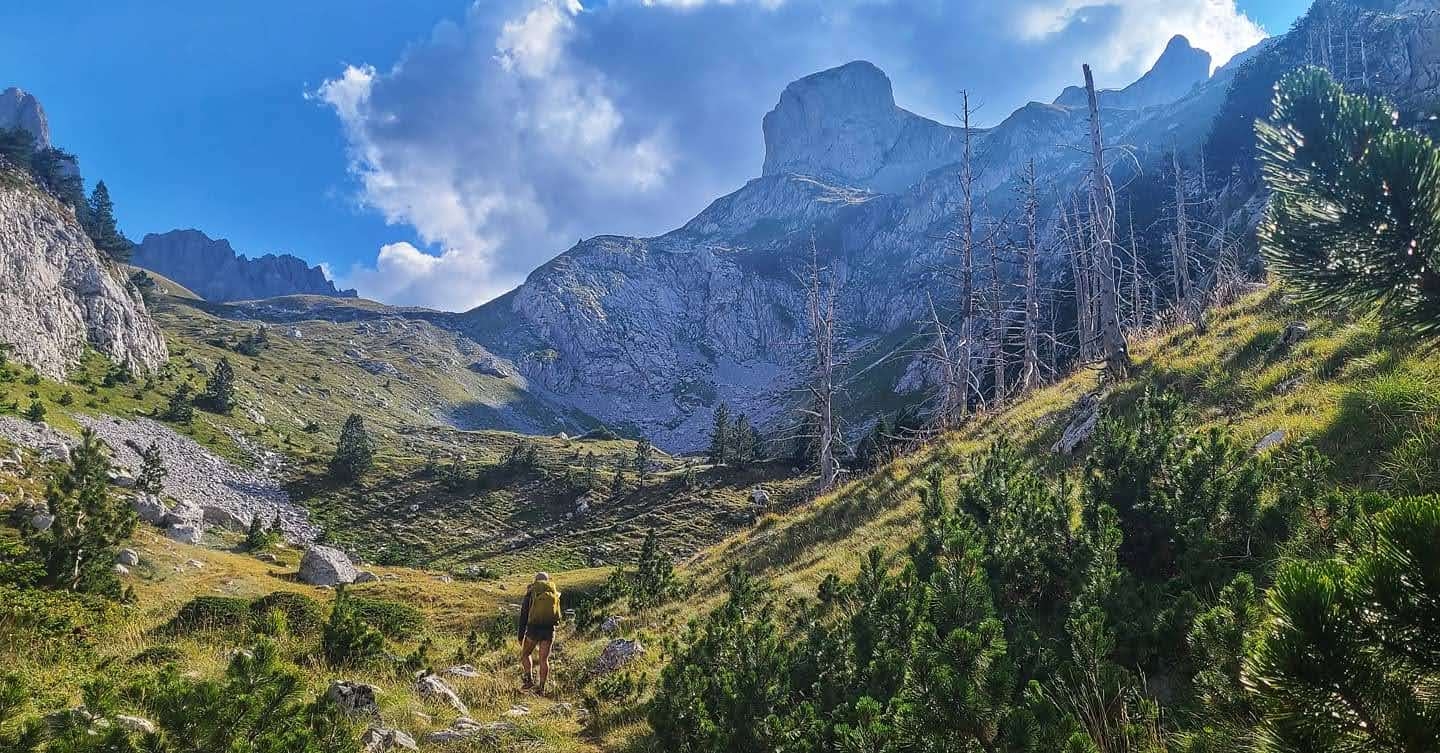
Entering the Accursed Mountains, Montenegro.
Basic Info
- Distance: 850 miles (1400 kilometers)
- Expected Completion Time: ± 8 weeks
- Total Elevation: 140,000 feet (42,672 meters)
- Location: The Dinaric Alps, AKA The Dinarides in Southeastern Europe (Balkans): Slovenia, Croatia, Bosnia and Herzegovina, Montenegro, and Albania
- Season: Spring – Early Fall
- Trail Type: Point-to-Point
- Scenery:
- Slovenia: idyllic villages, caves, forested mountains
- Croatia: white karst rock, sea views, springs, epic mountain huts
- Bosnia and Herzegovina: dramatic peaks and rock formations, lakes
- Montenegro: high plains and meadows
- Albania: gray cliffs, rugged alpine passes, canyons/valleys
- Terrain: Extremely varied. The National Park trail systems are manicured, but there are also trail-less meadows, occasional bushwhacking, road walking, and some (generally optional) scrambling/climbing.
Navigation
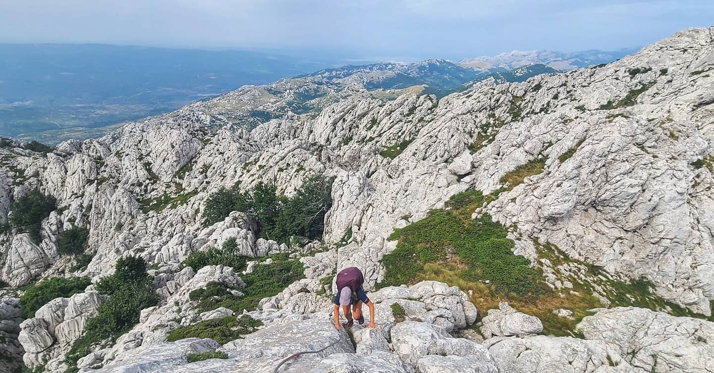
Climbing to the peak of Crnopac, Croatia.
The most important navigational tools on this trail are your brain and your eyes! Second most important is your phone (ideally with an international phone plan). With the available downloaded GPX from Outdoor Active on your phone or satellite device as your main guide, you must remain vigilant and cross-reference that path with the red/white blazes that usually mark the trails in these areas.
Other mobile maps can come in handy (Mapy.cz, MAPS.ME, AllTrails, Google Earth, Gaia GPS, etc.), but pay attention to local signage warning of hazards such as landmines.
An invaluable resource, the BH Mine Suspected Areas app, will help you safely traverse landmine zones. Another navigational resource is the book Via Dinarica: Hiking the White Trail in Bosnia and Herzegovina by Tim Clancy.

Bracing in the “Bora” wind overlooking the Adriatic Sea, Velebit, Croatia.
Getting There
Ljubljana, the capital city of Slovenia, is the real start of this journey. Here you gather and prepare your gear, start to learn some of the language (my first word was “pivo” — beer!), and enjoy the city’s vibrant culture. We especially loved the countless rose gardens and riverside café bars. There are tons of affordable places to stay and even some gear stores for the items you inevitably forgot.
The trailhead is at the foot of the Cliffs of Nanos, easily accessible from Lijubliana. A bus takes you to Planina, where you can spend the night to get an early start in the morning. Then, a 25-minute bus takes you from Planina to the small town of Razdrto. The trailhead is a five-minute walk from the bus stop.

Relaxing by the river, Ljubljana, Slovenia.
Direction
The Via Dinarica can be done in any direction. Because the terrain is much easier in Slovenia, getting progressively more strenuous as it heads southeast towards Albania, we hiked this direction to give our fitness a chance to improve with the increasing difficulty of the trail. From the north, it is best for most thru hikers to begin in June-August. From the south, hikers may want to begin later to avoid dangerous snow conditions in the high peaks of Albania.

Descending from Kučki Kom near the Albanian border, Montenegro
Why Hike This Trail
Every trail is different, but the Via Dinarica is entirely unique. If the cheap beer and breathtaking scenery aren’t enough, the cultural experience of traveling through the former Yugoslavia on foot cannot be overstated.
Hiking the White Trail is a gateway to a kind of solitude that many people in the modern, developed world have never experienced. It’s like walking back in time. You can go days without seeing a soul, and when you do it might be an old shepherd on horseback herding sheep towards his hut in the mountains. On this trail, you will cross borders, sleep next to ancient churches, and wander past minefields and bullet-riddled buildings. The isolated villages offer more heartwarming hospitality than you can imagine.

Theth, Albania.

Tanks near the foot of Dinara, the highest peak in Croatia.
Weather and Wildlife
The Via Dinarica is easiest to hike in the summer season, as there can be considerable snow in the Dinaric Alps. It is important to note that summer temperatures can be quite high at lower elevations. We experienced temperatures of over 95°F (35°C) during the day, and the heat often persisted through the night. Up in the mountains, the climate is more temperate: warm days and chilly nights but nothing below freezing.
Expect some periods of rain, hot stretches with little to no shade, and a wide range of overnight temperatures. Regions such as the Velebit in Croatia are notoriously windy but provide ample huts to sleep in or camp next to for a wind buffer.

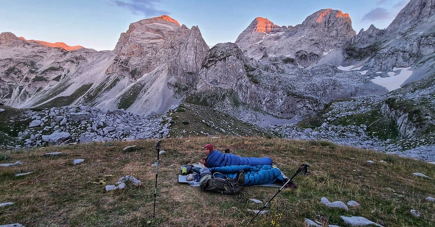
A wet and grueling climb up Planinica, Durmitor National Park, Montenegro.

We used this church as a buffer one windy night in Veliko Rujno, Croatia.
You may encounter abundant wildlife, including brown bears, gray wolves, Eurasian lynxes, red foxes, boars, chamois, wild horses, nose-horned vipers, and most annoyingly prevalent of all: mice.

A friendly wild stallion in National Park Paklenica, Croatia.
Gear Suggestions
Phones were our most valuable piece of gear, and a Google Fi phone plan allowed us to never worry about international coverage. Having crossed dozens of borders with Google Fi, we highly recommend having an international plan to avoid the logistical nightmare of changing SIM cards when moving between countries in remote regions. If you want to sign up, feel free to use our referral code FFF972 for $20 off! The super-cheap Flexible plan gives you coverage in almost every country in the world with data for $10/GB. We used this plan quite often for navigation, translation, finding accommodation, etc.

Walking past Buško Blato, just across the border into Bosnia and Herzegovina. Definitely nowhere to buy a sim card here!
A flexible sleep system is important due to the variable temperatures at different elevations. We love our Katabatic Gear Flex Quilts for adventures like this. We used a tarp for our shelter, but in hindsight, I suggest bug netting for those hot nights when you don’t want to be under your quilt but want to avoid being eaten alive by mosquitoes.

Setting up camp by Orla Kuk, Bosnia and Herzegovina.
A food hanging system, or bear canister if you prefer, is also a good idea. If you leave food out overnight rodents will get into it. No question. In the high meadows, we would simply keep food off the ground by hanging it from a trekking pole. A Cnoc Vecto and Sawyer worked great for water filtration/retrieval. We did not bring a stove since only the old puncture-style Campingaz canisters are (rarely) available. To use these, a compatible “vintage” camping stove would be necessary.

A yummy stove-less meal at mountain hut Planinarsko Sklonište Crnopac, Croatia.
Camping
You will find a multitude of indoor sleeping opportunities along the Via Dinarica. We probably could have spent most nights under a roof if we had wanted! As previously mentioned, an incredible network of well-spaced mountain huts exists. Some are unmanned and completely free, others have lovely hosts that feed you and share valuable insight into the trail ahead.

The mountain hut Šugarska Duliba in the Velebit wilderness, Croatia.
Small guesthouses in the villages along the trail allow you to experience the local culture, food, and exceptional hospitality. Booking.com or Airbnb advertise some of these guesthouses. Otherwise, you can look for signs or ask around town. Since posted information isn’t always reliable, you will want to call ahead if possible.

A stunning spread fresh from the garden made by our hosts in Lukomir, the highest elevation village in Bosnia and Herzegovina.
Since most of this region is sparsely populated and has few regulations, there are ample opportunities for wild camping. We enjoyed cowboy camping most nights.
Cowboy Camping below Maja Jezercë, Albania.
Highlights
The White Trail visits most of the highest peaks of the Dinaric Alps which all offer spectacular views. WWII-era bunkers, ancient stone tablets (Stećci), and beautiful caves and castles lie directly in your path. On your very first day hiking southbound, you will come to Predjama Castle, the world’s largest cave castle! You will also enjoy natural springs like Izvor Kupe in Risnjak National Park, and world-famous huts designed by architect and mountaineer Ivan Juretić in the Velebit wilderness. Some one-of-a-kind natural phenomenons along the path are the rock arch Hajdučka Vrata “Outlaw’s Gate” and the heart-shaped lake Trnovacko.

Overlooking Trnovacko lake, in the shadow of Maglić, the highest peak in Bosnia and Herzegovina.
One of our favorite places to resupply was Knin, a historical Croatian city directly on the trail. Dinner at the Knin Fortress is a must. You’ll get incredible views of where you came from and where you’re headed! I’d also recommend taking a little vacation from the trail to visit Senj, Dubrovnik, Split, Sarajevo, or Mostar. Enjoy a zero day doing anything from wine tasting to whitewater rafting. Best of all, you can relish the serenity of having this trail completely to yourself.

Taking a quick vacation from the trail to visit Mostar, Bosnia and Herzegovia.
Water Sources
Finding water can be difficult later in the summer. But the Balkan’s unique shepherding culture often provides accessible water even in remote places. When buckets weren’t available at deep cisterns, we would access the water by rigging up our water bladder (weighted by a rock and attached to our bear-hanging rope). Most mountain huts have water inside or nearby. Obscured water sources are marked “Voda” with the same red paint as the blazes. Often, trickles of water come from pipes dotting the primitive roadsides between settlements, thanks to either practical local herders or Ottoman-era infrastructure.

Fresh water beside the road, southeastern Bosnia and Herzegovina
You will pass many cafes in small towns along the trail where you can not only fill up on water but also enjoy a cappuccino or a beer! I recommend the capacity to carry 4-6 liters per person during the summer heat, possibly more if you want the option to dry camp. Many sections with an abundance of water allow you to carry less than a liter at a time. But be prepared for an occasional carry of up to 20 miles (32 kilometers).

Filtering water from an unnamed alpine lake on the Montenegro-Albania “green border.”
Resupply Options
In contrast to more established trails like the PCT or El Camino, no accessible mail drop resupply system exists for the Via Dinarica. We relied mostly on local markets. You will frequently pass through pockets of civilization ranging from large towns with major grocery stores to tiny settlements with little infrastructure. There, local residents may insist on having you for lunch and rakija, sending you on your way with some homemade bread and cheese.
We usually carried two to three days of food with us, but never had to go more than five days between resupplies. We only hitchhiked into towns twice to resupply since most options were right off the trail.

This family insisted we join their picnic by the Cetina River, Croatia.
Resupplying gear is another story altogether. A handful of stores like Decathalon carry athletic clothes, running shoes, and some very basic camping gear. To find a replacement for a destroyed air pad, we embarked on an adventure off the trail from Jablanica and found a store called Aqua Balkan that had some serviceable gear options. If you need any specialized gear, you’ll have to think outside the box.

Leaving the coastal town of Senj, Croatia after hitching down for a successful resupply.
Closing Thoughts
The Via Dinarica White Trail is not for the faint of heart. It is, however, entirely accessible to hikers hungry for adventure. If you’re looking to cruise along and crush big miles each day, join a tramily, or stick to a plan—this hike is not for you. If you want to get off crowded trails, learn about new cultures, and are able to fly by the seat of your pants, then the Via Dinarica awaits.
This trail is more than just utterly unique, exhilarating, and challenging—it’s transformative. Standing at the trail’s end, with no monument or fanfare, you can look down at your toes through the holes in your shoes triumphantly. Your odyssey is complete, having walked through the far and wild reaches of southeastern Europe. You just might find that you don’t see the world quite the same.

Descending Maja Jezercë, the highest peak on the Via Dinarica, Albania.
Do you want more info on the Via Dinarica White Trail? More questions about its unique logistics, such as border crossings, language barriers, minefields, and food options? Want access to our full recorded GPX tracks from our 2021 hike? Curious about the Blue Trail, Green Trail, or existing extensions into North Macedonia and Kosovo? Let us know in the comments below. If there’s interest, I’d love to write a more in-depth article!
More Helpful Links:
Our Instagram, where we posted daily updates on the trail.

This website contains affiliate links, which means The Trek may receive a percentage of any product or service you purchase using the links in the articles or advertisements. The buyer pays the same price as they would otherwise, and your purchase helps to support The Trek's ongoing goal to serve you quality backpacking advice and information. Thanks for your support!
To learn more, please visit the About This Site page.

Comments 20
What a great overview of a trail that most of us have never heard of! It’s nice to get exposure to a non-traditional trail that offers true adventure where hikers must be more self-reliant relative to the more established LDTs in the United States. The pictures and descriptions are inspiring and have definitely piqued my interest. Thanks for taking the time to share your adventure!
Wow, thank you for taking the time to read it! There is such a wide range of trails out there—truly something for everyone. Trust me when I say the pictures don’t even come close to doing it justice! I’ll be on the PCT this year, so looking forward to seeing the other side of the spectrum.
What a great article about a fascinating trip! Hope your next one is just as good!
Thank you, Mr. Durban!
We just became so excited while reading this article. We also took many notes as we’re busy planning our White Trail hike this summer! We’d love to take you up on your GPX files offer 🙂
Thank you!
YES! Absolutely! I just need to work on getting them formatted for export. Then it’s all yours! I hope the info proves helpful on your and Magdalena’s adventure.
Nice write up! It is a great trail. I would argue that where the beginning of the trail lacks some difficulties as far as physically demanding trail it makes up for that in difficulties in navigation.
I hiked it in 2019 and recorded hundreds of Waypoints that can be downloaded here https://superhiphikes.wordpress.com/via-dinarica/?fbclid=IwAR0n2nTnELp3kcUH0_mItXXeCEnvbE0ddGGFdA_axOeW2KDtGj6xFKvj_Xc#jp-carousel-270
I hope you don’t mind me posting this here. Just trying to help the community.
Hey Superhip, I totally agree! Your linked blog is AWESOME, thank you for posting it here. I’m surprised I didn’t come across it in my research before. Looks like you are a very accomplished hiker. I hope to meet you thru-limping past me one day!
Nice write up! It is a great trail. I would argue that where the beginning of the trail lacks some difficulties as far as physically demanding trail it makes up for that in difficulties in navigation.
I hiked it in 2019 and recorded hundreds of Waypoints that can be downloaded here https://superhiphikes.wordpress.com/via-dinarica/?fbclid=IwAR0n2nTnELp3kcUH0_mItXXeCEnvbE0ddGGFdA_axOeW2KDtGj6xFKvj_Xc#jp-carousel-270
This sounds very interesting! I travelled in Serbia and Bosnia & Herzegovina few years ago and was thinking that there would be so great hiking destinations in the Balkans. Perhaps I have to put this on my list.
I remember thinking the exact same thing the first time we traveled though the area in 2016. Back then was when we first heard whispers of this “mega trail” in the works… And here it is! Truly a traveling thru-hikers dream.
Hello Louisa, is it possible to do just some (of the easier parts) of this trail? I am coming from Tasmania, Australia to the Netherlands in early May and looking for a 10-14 day hike but coming so far it is a little more difficult to be really organised. Also I have dietary restriction of gluten-intolerance and feel a bit awful if I don’t stick with this. Ideally parts where there is access to some basic accommodation and food/water. I did the Overland Track here with my son and had no problems with that, but looking for something longer but a bit more food access.
I absolutely love this post, hearing of your experience. Thank you.
Hey Katherine! It’s definitely super doable to do small sections of this trail. My first thought is that you’d enjoy starting in the Park Prirode Velebit in Croatia. 10-14 days through there would time out pretty perfectly. My second thought would be to start in Bosnia in Nature Park Blidinje and follow the trail into Montenegro. Your biggest obstacle will be your dietary restrictions – A good loaf of bread was usually our main staple. That said, you will still find some good GF options. Unless you’re vegetarian/vegan too, then you’ll really just be chewing on sticks to survive. The gluten-free foods we usually ate out there were sausage, cheese, and pâté. In towns we were served lots of grilled meat, stews, roasted peppers, tomato/cucumber salads, and rakija. With a bit of creativity (and possibly a bit of monotony) you can still make it work and have a wonderful time!
This sounds like such a crazy awesome hike. I’ve hiked all over the US and Europe and never heard of it… Definitely adding it to the list. Those pictures are WILD! Would personally be very interested in another more in depth article from you.
Love the write up! Would love to read a longer one too!
Hello, thank you very much for the article 🙂 I’m quitting my job and in Jul I’m setting off for the white trail. Good to know of the water situation, can I ask what were the lowest night temperatures? I’m thinking about taking my lighter sleeping bag, tested in 10°C cowboy camping (underwear +T-shirt comfy), with good sleeping mat and tent, can it do the job? Do you probably have the exportable gxp?
Thank you so much – this trip report is truly mouthwatering.
While I’m an avid thru-hiker, I won’t be able to do a longer trip this summer.
Is there a section you’d recommend? My specs would be:
– 300-400km section to hike this August.
– single trails, little to no forest roads
– rather challenging terrain over flat walks
– captivating Landscapes, I’m driven by eye-candy
– ideally more remote than busy with people
Thanks!
Hi, my wife and I are considering a trip to Bosnia and Croatia next summer. We have a habit of doing 50% hiking and 50% lazy. For the hiking portion I’ve been looking at the Blidinje Nature Park. I’ve found a lot of guided trips, but I’d really prefer to do it without a guide, is there any difficulty in solo hikes along this area? Is it safe to leave a car parked at the base for a few days while backpacking? or is it better to figure out some way to get a drive in and picked up for the way out?
thanks!
Tyler
Hi,
Thanks for a great post! I’m in Zagreb wondering where to start the white Trail. I have 30 days of hiking and I’m (almost) ready to go. How did you protect your food. Just with rope?
Where would you start for a 30 day mountainnous adventure? Also I’d love some tips on resupply spots 🙏
I was supposed to hike in Slovenia, but due to poor trail conditions, I had to change plans the same day I left home.
Thank you!