 ">
">
Bushwhacks and Blowdowns (PNT Pt. 8)

The snow continues as I keep pushing towards the coast. The Selkirk Range has been some of the most spectacular mountains I have seen yet on trail.
Crossing the Valley
I walked up Highway Ninety Five, mistakenly missing where I was supposed to drop down the embankment. It was easy to miss, as there was no trail, just a steep slope down through tall grass and trees.
After missing the drop down point by almost a quarter mile, I had to backtrack down the hill. Choosing a point to drop down, I descended, and halfway down, a large rock tumbled out from under my foot. I had to catch myself before I went rolling down the hillside.
“Fuckin’ Fuck,” I breathed. Does not matter how many times I have descended scree, one day I will break my leg because I was over confident.
I got to the road at the bottom and proceeded to walk the next ten miles to the trailhead. There was no public land through the valley, and though I saw many places that I could have stealthed, I chose to push on. Seeing me wandering in the middle of nowhere in the dark, several people slowed to stop next to me to ask if I was okay.
“Oh, yeah, I’m good,” I’d say. “I’m just thru hiking the Pacific Northwest Trail.”
They would all nod in confusion and then leave me be.
I was particularly annoyed on one instance. Not having seen a car in some time, my headlamp caught the green light of a cats eyes, watching me from on top of the embankment. I turned to climb the slope, wanting to pet the kitty, and then a car came by, pulled into the nearest driveway, and turned around to see if I was okay. As much as I appreciated the concern, I was very annoyed at the interruption.
As I got deeper and deeper onto backroads, I turned off my light so I could get a look at the stars. In the near total darkness, I could make out the outline of the sides of the road in the starlight, continuing straight, ever on into the distance. I traveled in that way for over a mile, appreciating the Milky Way as it spilled across the heavens above me.
As the night dragged on I listened to Nana Grizol’s 2020 album, “South Somewhere Else,” and Trampled by Turtles 2012 album, “Stars and Satellites.”
Dirty, Dirty Trailheads
I reached the trailhead at the base of Parker Peak around one thirty in the morning and struggled a bit to find a place to set up before finally choosing a flat spot in the middle of the side trail that led down to the stream. The buzzing of flies that woke me in the morning led my eyes to a surface shit some local had taken no more than a week or two prior, less than four feet from where my tent was set up, right next to the stream.
Blowdowns and the Gods
I packed up and got out of there, beginning the slow slog up the mountain to the ridge. The ascent was five thousand feet over ten miles and highly exposed. I put on Stephen Fry’s “Mythos” and listened to Greek myths told in a dry, English wit as I navigated the constant network of blowdowns that crossed the mountainside. There was no water for that whole ten miles and it took me the entire day to gain the ridgeline.
The views from the top were spectacular and I marveled at the sunset. I could see in the distance that there was still quite a lot of snow up at elevation. Through the course of the entire day, I only managed to make it twelve miles. The situation frustrated me to no end, but I let myself accept it for what it was; something I could do nothing about.

The Selkirks
Ticks
The next morning as I climbed out of my quilt, I found a tick crawling up my thigh. There were three more nestled happily in my right armpit. I had found over half a dozen on me the day before and had done an extremely thorough check before going to bed. I could not believe so many were in my tent when I fell asleep.
Get Out the Ice Axe

Staring up at the pass below Pyramid Peak.
Rearing to go, I told myself that I would do a bigger day today. I did, but only by three miles. I was not expecting it, but I found myself facing an extremely steep pass below Pyramid Peak. The snow grew deep, causing the angle of the slope to be so great that I did not have confidence about making it across the traverse. The snow’s soft surface gave me doubts about being able to self arrest fast enough with my ice axe, while simultaneously not being soft enough to sit down in were I to slip. The drop below the trees was precipitous, a potentially deadly fall into rocks and trees far below.
After a few moments thought, I chose to try to gain the pass by heading straight up. I often find it easier to ascend in that way, climbing directly upwards, and it looked like I could make it to a scramble, out of the snow, that I could easily climb up to where the slope leveled out.
I made it up to the top of my climb and found myself at an impasse. A buried crevasse blocked me from going higher, and the slope angled slightly harder to my right, as well was blocked by a young tree. I felt out the crevasse with my axe, discerning the lip of it and slowly inching my way up along it. I had to jam myself between the slope and the tree, clawing my way up and around until I was high enough around the buried rock that the crevasse vanished. Even then I found myself at another impasse. I looked down at the steep, almost unnavigable slope back down and started feeling regret for my decision.
Directly above me the rock sloped down hard into the snow, melt water slicking the surface. Even without being soaked, that face would have been hard to climb. My only option was a traverse at a slight angle upward to my left, just over ten feet across to make it to a dry rocky outcrop. It was dense with bushes, but I could use them to pull myself up and then force my way through to the crack that ran up through the cliff to the next tier. Even with how steep the angle was, and the drop below, I told myself that ten feet was better than what I would have had to do following the red line. I made my way across and easily climbed up, coming out into the massive boulder field on the tier above. Navigation from there was easy and I cleared the pass without incident.
Beyond the pass, I trudged along through the snow until I came to a ridge run. Snow drifts on the ridge were easily over ten feet deep and had massive overhangs. I ran across it, slipping and sliding joyously down each little hill of snow. Finally, I sat down and ate lunch, knowing that I would have to descend the ridge and drop out of the Selkirks soon, the next six miles being a bushwhack through the valley below. The miles of the last two days seemed like some kind of joke.

Running the ridge before dropping down into the bushwhack.
Crashing Through the Forest
The bushwhack was easy for the first two miles. The snow kept everything clear and I slid down the mountain towards the valley bottom with abandon. Traveling got much more challenging when I came down below the snow line, and I found myself pushing through shrubs and mire. A solid looking patch of moss saw me sink up to my knee in muck. The stream was freezing from the melt and I crossed it several times trying to follow animal trails.
I fell hard, three times throughout the bushwhack. The last fall, I was trying to cross some blowdowns and my shoe completely lost traction as I walked up a log. I face planted, dropping an extra two feet and jarring my skull. When I got up, I did not have a scratch and my head only felt a little rattled.
The valley cleared up a bit after the river turned. It was marshier in places, but easier to follow the animal path that led through the woods. I came face to face with a black bear standing on a log less than ten feet from me and then another later on, that kept running forward and then stopping so that I would catch up with it.
Also, I realized later that I lost my water bottle when I fell.
A Daily Consensus
I am reading through my journal entry for the day and thought I would share the conclusion with you all.
“All in all, general chaos reigned throughout the day and I am very tired. Planning on at least 25 miles tomorrow to make up for this continued nonsense. Lots of screaming. Yours truly.”
The Open Road
Before the day ended I came out onto some of the nicest trail I will probably see for this whole trip. It was wide and flat and beautiful and I camped on a completely flat surface, under tree cover, next to clear flowing water.
In the morning the trail came out onto a forest service road. I found that the trail turned off of this road to summit a mountain and then dropped back down again. I opted to continue forward towards Priest Lake instead of doing the pointless up and down. Some people may see this as cheating. I do not really care.

Priest Lake
In fact, I covered forty trail miles over around thirty plus miles actually walked. The day was wonderful, except that it had the worst mosquitoes that I had yet experienced on the PNT. The fuckers were vicious, especially on the trail around Priest Lake, and I had to set up my tent to eat lunch. My hat was literally stained black in places from how many I killed just on the brim.
Strangers on the Path
After I packed up from lunch, I met two motorcyclists at a three way intersection. We had all come down a different road and decided to stop. One of them was an eccentric older Frenchman, the other, an IT guy from L.A.
“You are walking?” asked Jacque, the Frenchman. “This is why you are so fit. This is good. Be sure you stay that way. Do not get fat, like me. You will be better off than the rest of us.”
As I left, Jacque remarked, “you have the body of a gazelle, and I bet you have the heart of a tiger.”
The Weather on Caradhras
There was a big official alternate, almost all the way from Priest Lake to Sullivan Lake, around forty miles by the red line (official route), which comments said was a bushwhack, and around thirty six miles by way of the alternate. I took a third option, slowly climbing all day until I reached a pass where the alternate crossed.
I got to the pass late, around ten o’clock. My plan was to pick up the alternate where it crossed the forest service road, but I overshot it by over half a mile. Not seeing anywhere I could camp along the road, I backtracked all the way up to the pass to set up on a flat spot at the top, the only place clear of trees and steep slopes above it. There was a better spot I could have set up before the pass, but I decided to continue on because of a calculation I was trying to figure out.
In the Two Towers, Treebeard carries Merry and Pippin seventy thousand Ent Strides to his home in Fangorn. He does it easily, in a matter of hours, if I understand correctly. Well, Tolkien describes Treebeard as looking to be about fourteen and a half feet tall. I pushed on, because according to my phone I was less than a thousand steps shy of seventy thousand. So, in case you were interested, I estimate seventy thousand Ent Strides to be a little shy of ninety miles. You are welcome.
It started to pour heavily before I got my tent set up. The storm hit all at once and was directly over me in the pass. I felt excessively exposed and wondered, not for the first time, if the iron shaft of my ice axe could act like a lightening rod.
The rain was driving for most of the night and continued as a drizzle for most of the next day. In my tent, I used my maps to plot out a route, opting finally to continue on the forest service road instead of taking up the alternate so that I could get into town a day early. With that decided, I fell asleep.
Difficult Paths
The next day I headed straight down from the pass. There was a road that was supposed to branch off, several miles hence, that would take me down into the valley. I kept an eye on the GPS to make sure I knew when to turn, and still managed to pass it by a quarter mile.

Fog in the valley as I descend the pass.
I backtracked uphill and soon came to realize why I had missed it. The road that I had planned on taking was an old abandoned logging road that was still displayed on all the maps. It had trees growing in the center of it that had to be ten to fifteen years old, maybe older.
I thought about this, and thought about how it was four or five miles uphill back to the alternate. Also, I thought about how the forest service road I was currently on might eventually curve back around and lead to Sullivan Lake. In fact it had to, based on the signage at the bottom of the pass on the other side. However, I did not have the maps downloaded far enough out to show how long it would be till the road turned to head back in that direction. The worst part is that, regardless of what I was thinking, I knew exactly how many miles out of Metaline Falls I was on that road. The sign at the bottom of the pass had told me how far it was, and I had a good grasp of how far I had gone since then.
Still, In my mind, there was a clearly discernible path in front of me, if a bit overgrown. I hate changing my plans, regardless if they are ill conceived, and I resolved to take the logging road. Soon I was shrouded by the canopy of the forest.
I had my rain layers on because of the drizzle that had persisted all morning. Before I had made it more than a few hundred yards, they were soaked from all of the wet brush I was fighting through. Travel actually was not bad, and I made slow but continuous progress down into the valley.
Sometimes the plants grew thicker, but the road was always there and I was always able to fight my way through. Thinking of Ents and Entish trees, of Hobbits, and of the woods outside the Shire, I asked the trees if they would let me through. They did not oblige.
Sometimes the road would make extra switchbacks that were not shown on the map. I took to heading straight down the side of the mountain into the valley. I made quick progress this way and soon was at the road that ran along the river. My slim hope that it would be a full forest service road was quickly dashed.
Well, Maybe that was a Mistake
I looked at my surroundings, having just slowly scaled my way down a steep embankment. The plant growth along the river was much denser than what I had passed through above, and the path was narrow. There were no alternate options to get around an obstacle when the path was choked. Coming upon a literal wall of blowdowns, I began to reassess.
According to my map, I had to follow the valley for just over two miles and then the road would turn ninety degrees into another valley. That road clearly led to Sullivan Lake some ten plus miles distant. It was the shortest route I could take. However, there was no indication that the route would grow any easier. I swore, loudly, and started climbing the two mile bushwhack back up to the road. It took over two hours, and by the time I came out from the muggy suffocation of the forest, I was so thoroughly drenched that I was shivering. My rain layers were useless.
Ah, what adventure.
Continuing on the Path
So, having wasted hours and hours of time, I continued on the forest service road. It did not continue far off my downloaded maps before crossing a bridge at the bottom of the valley and hooking back towards Sullivan Lake. I came to where the logging road would have come out after two miles and saw that it had a bridge across the stream and continued back, clear for as far as I could see. I laughed helplessly to myself, thinking how, in a way, I had added almost ten miles on to my day. Punishment for my hubris, I suppose.
The rest of the walk was easy, except for the cold, and my feet that throbbed from being wet all day. I came to the main road and as I walked, several people stopped to offer me rides into town, which I politely declined.
Finding Peace
The road walk was surprisingly beautiful, the sky clearing and the sun warming me under my wet clothes. Clouds wreathed the peaks of mountains that loomed above, and off to my left the valley dropped sharply down to the rocky river, winding away towards town.
As I walked into town I spotted Mountain Lady’s Slippers tucked away off the side of the road. This variety of orchid is my favorite kind of flower and it always delights me to find them. I had no idea Washington state had them.
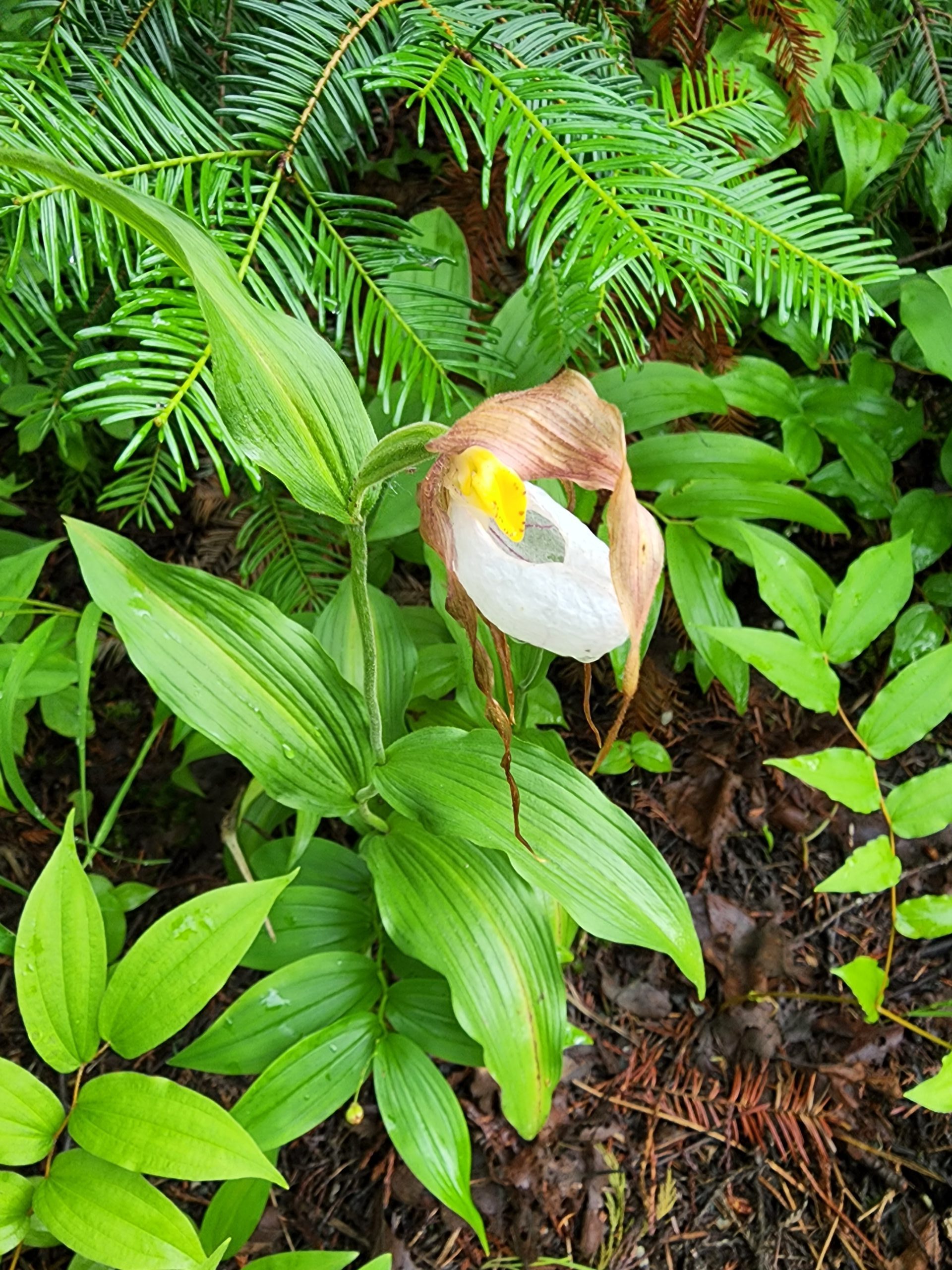
Mountain Lady’s Slipper
After the descent down, I climbed the road up into the town of Metaline Falls and made my way to sit down in the shelter at the town park. My original thought was to find a place to stealth camp at the edge of town, but I soon found myself gravitating to the Historic Washington Hotel across the street. I called them and asked the price, and though it was too expensive for my budget, I was over there with a room, getting dry, before I knew it.
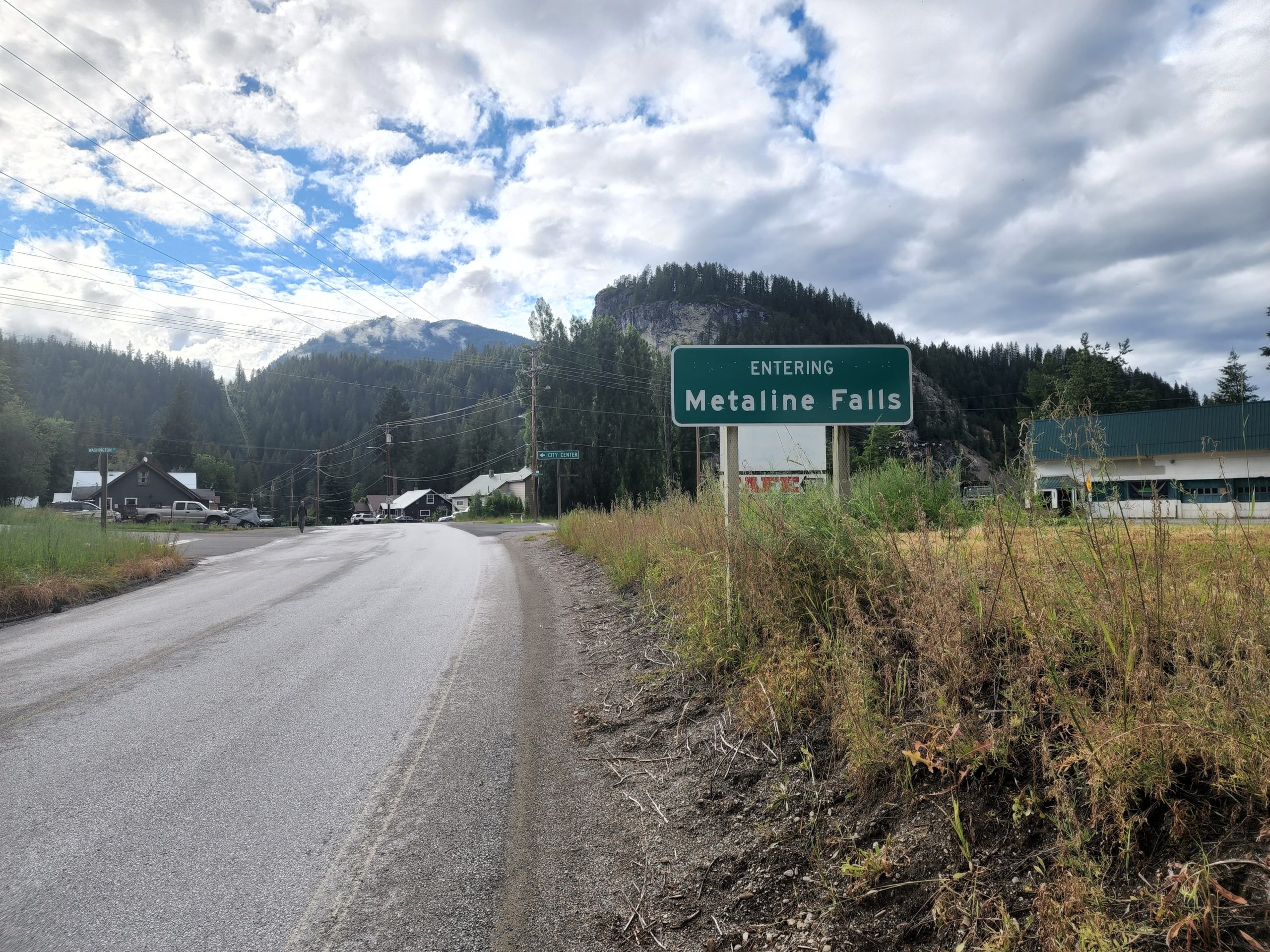
Roadwalking into Metaline Falls, WA.
And so, I was vortexed.

This website contains affiliate links, which means The Trek may receive a percentage of any product or service you purchase using the links in the articles or advertisements. The buyer pays the same price as they would otherwise, and your purchase helps to support The Trek's ongoing goal to serve you quality backpacking advice and information. Thanks for your support!
To learn more, please visit the About This Site page.

Comments 1
Thanks for the Ent conversion.