 ">
">
Hike Sheltowee Trace: Kentucky’s 323-Mile Long Trail
Sheltowee Trace At a Glance
Length: 323 miles
Location: The trail runs from Big South Fork National River & Recreation Area in Tennessee to the northeast corner of Kentucky.
Trail Type: Out and back, or shuttle
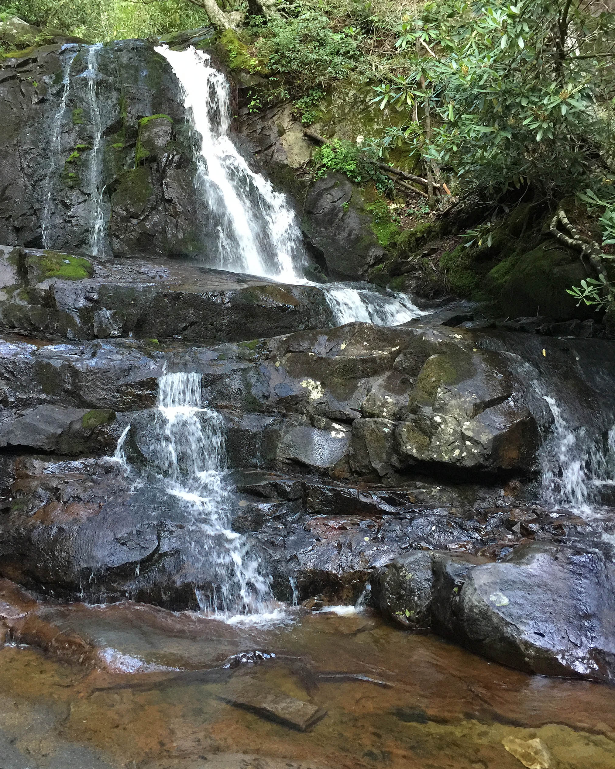
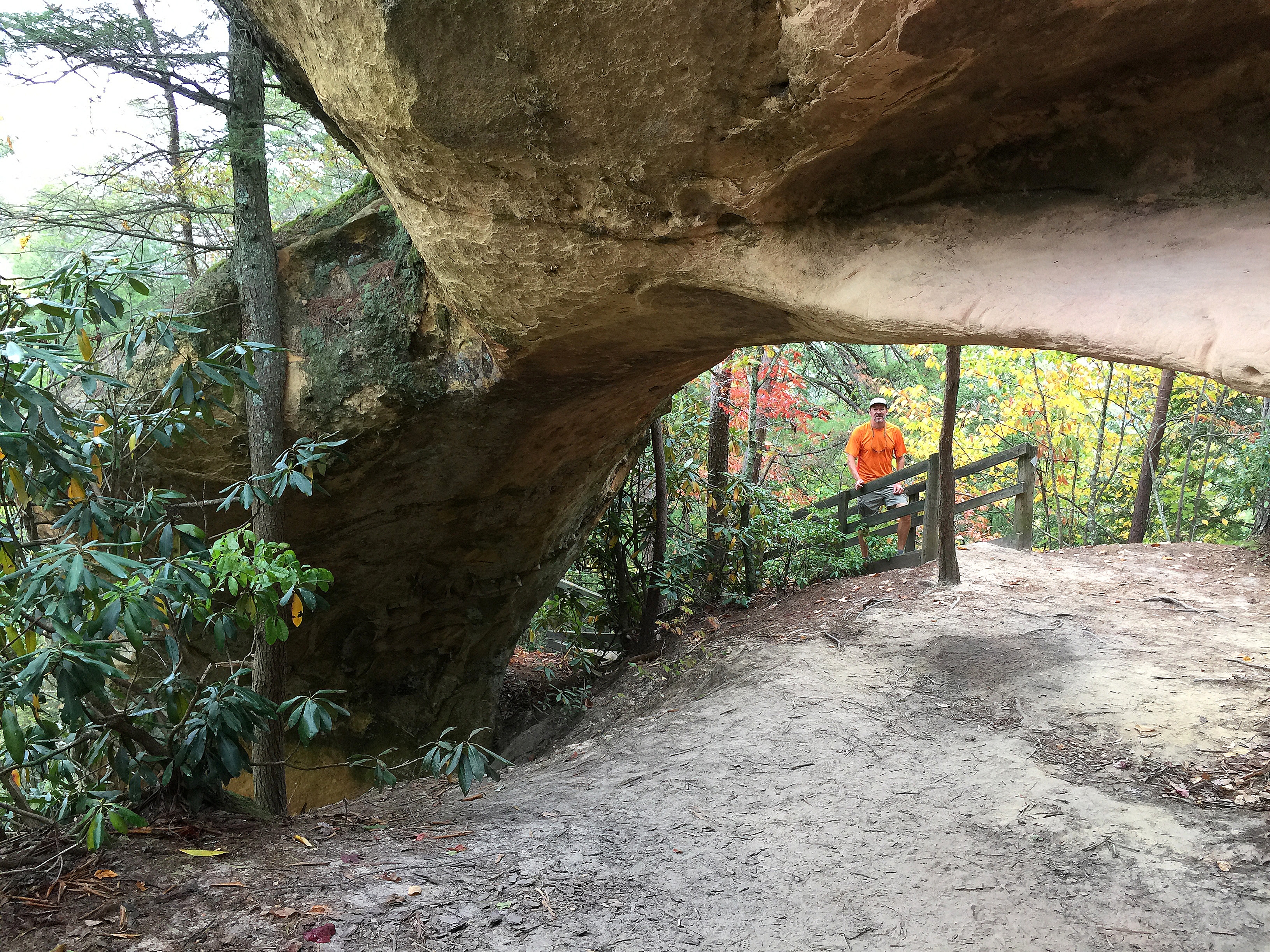
Scenery: Most of the trail is on the Cumberland Plateau in Daniel Boone National Forest or in assorted state and National parkland. There are great views throughout, impressive waterfalls and several natural bridges. Time yourself to be at Cumberland Falls (the Niagara of the South) during a full moon and enjoy one of the few places on earth with a consistent Moonbow. (A black and white version of a rainbow caused by the mist from the falls and light from a full moon.)

Trail Overview

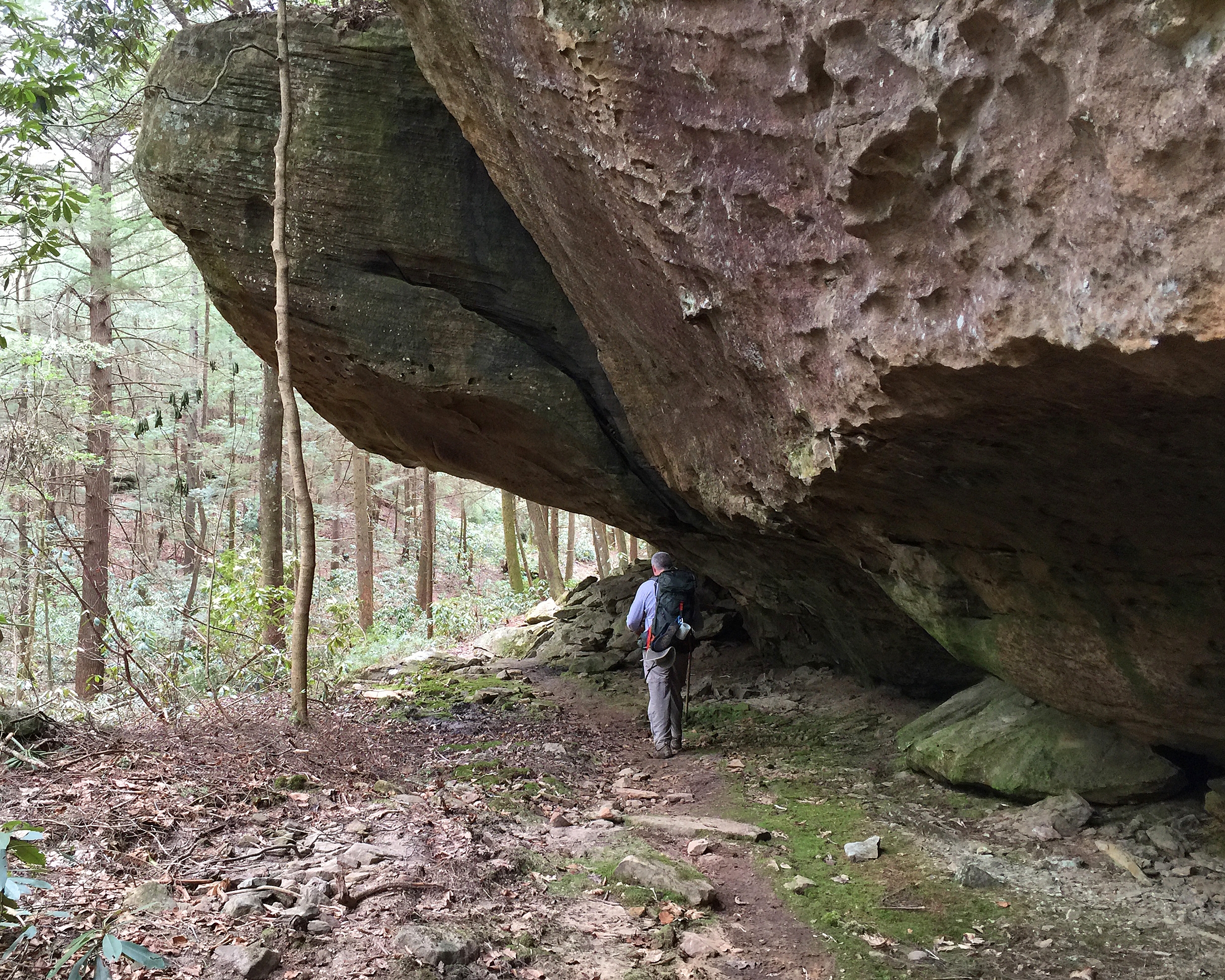
“Kentucky’s Long Trail” is named for Daniel Boone, who was given the name Sheltowee, or Big Turtle, when adopted into the Shawnee tribe. The trail features numerous waterfalls, natural arches, sandstone cliffs and tremendous views. It even passes by a spot where clear skies and a full moon generate a moonbow. Sections of the trail are located in Big South Fork National Park, Daniel Boone National Forest, Cumberland Falls State Park, Natural Bridge State Park and Red River Gorge. Originally completed in 1979, the path is administered by the Sheltowee Trace Association (STA), and is still being extended and improved.
Terrain

Most of the hiking would be considered moderate. There are some steep climbs/drops but few total over 500 feet in elevation change. The toughest part for me were some extensive sections of road walking; several miles in a few instances. Bring water shoes; there are a number of stream crossings.
Navigation
Generally, the trail is marked pretty well with blazes in the shape of a turtle either nailed to trees or painted on trees, signs or roadways. A map set is available, very useful and sold here.
Getting There
To get to the northern terminus, take I-64 approximately 50 miles east of Lexington, KY to exit #137. Start north on Rt 32 then right on Rt 377 to the trailhead. Leave the car at the trailhead. If you’re starting at the southern end, the best plan may be to park at the Bandy Creek Visitor Center in the Big South Fork, pick up a camping permit and have a shuttle arranged to the terminus. From Oneida, TN, turn west on Rt 297 from US 27 and watch for signs to Bandy Creek Recreation Area. Check out the shuttle info here.
Why Hike This Trail?

If you’re from the mid-west or mid-south, there are few nearby options for a long hike. Sheltowee Trace is not only within reach for this Ohioan, it also hits my sweet spot in length. At 323 miles, the trail is long enough to be a life changing experience without being so long that you have to give up your existing life to hike it.
Climate and Weather
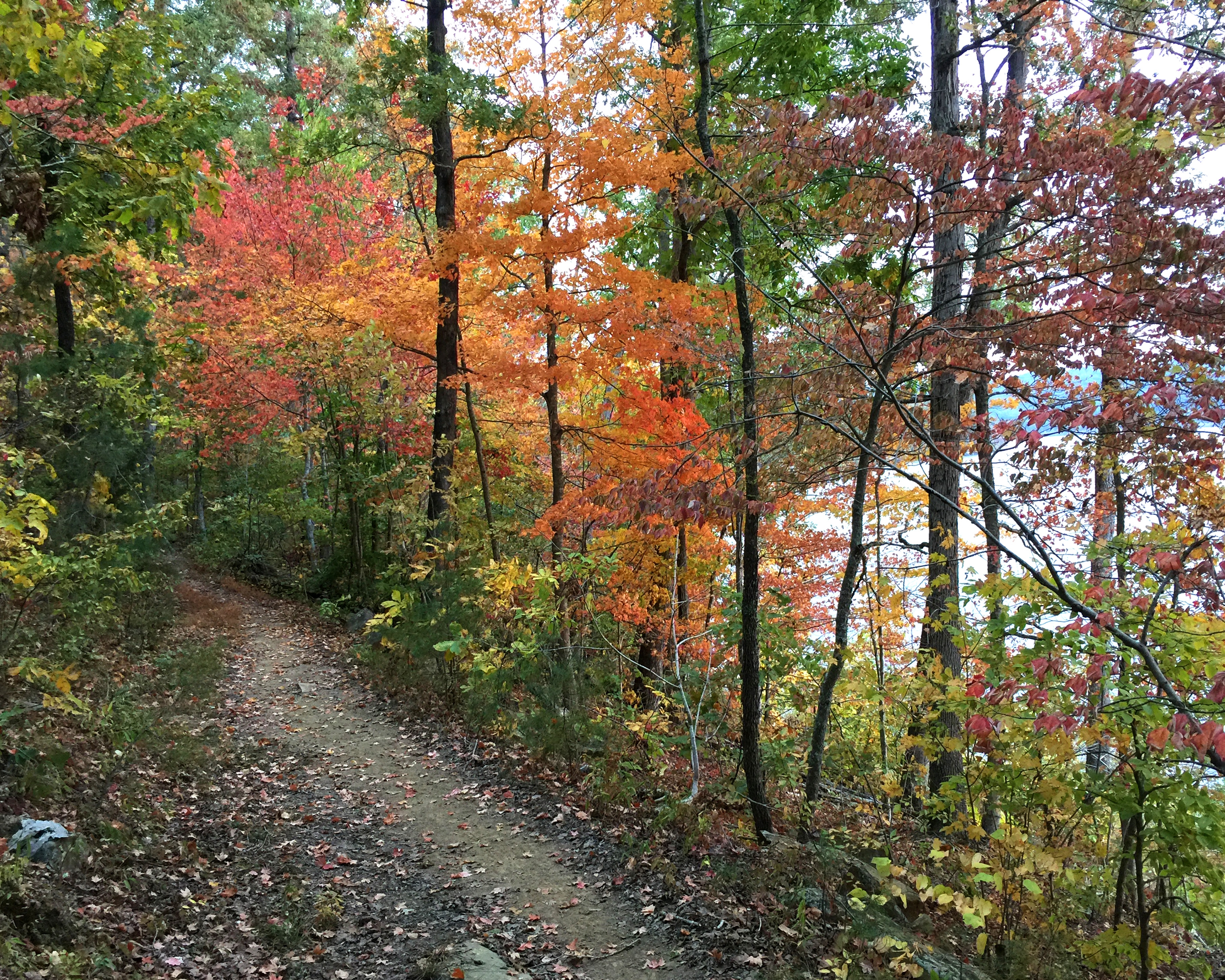
The trail is in “the south” and elevations are under 2,000 feet. While snow and ice can be an issue, generally the trail can be hiked year-round. Winter offers seclusion and countless views through the leafless trees. In spring, waterfalls and wildflowers are at their peak. Mid-summer highlights include humidity and ticks. Late summer and fall tend to have the most stable weather, fewer bugs and sparse crowds. My favorite time is October with dry air, cool nights and some tremendous fall color.
Camping
There is no permit required or fee to camp on undeveloped Daniel Boone National Forest Land. Either a tent or hammock should work. There is a permit ($5) required to camp in the Big South Fork which can be obtained at the Bandy Creek Visitor Center. Food must be “bear bagged” in both Big South Fork and Red River Gorge and it’s a good idea along the entire route. Best practices also include camping at sites that have already been “established” by previous hikers. Other options along the route include developed campgrounds at Kentucky State Parks such as Natural Bridge.
Water Sources
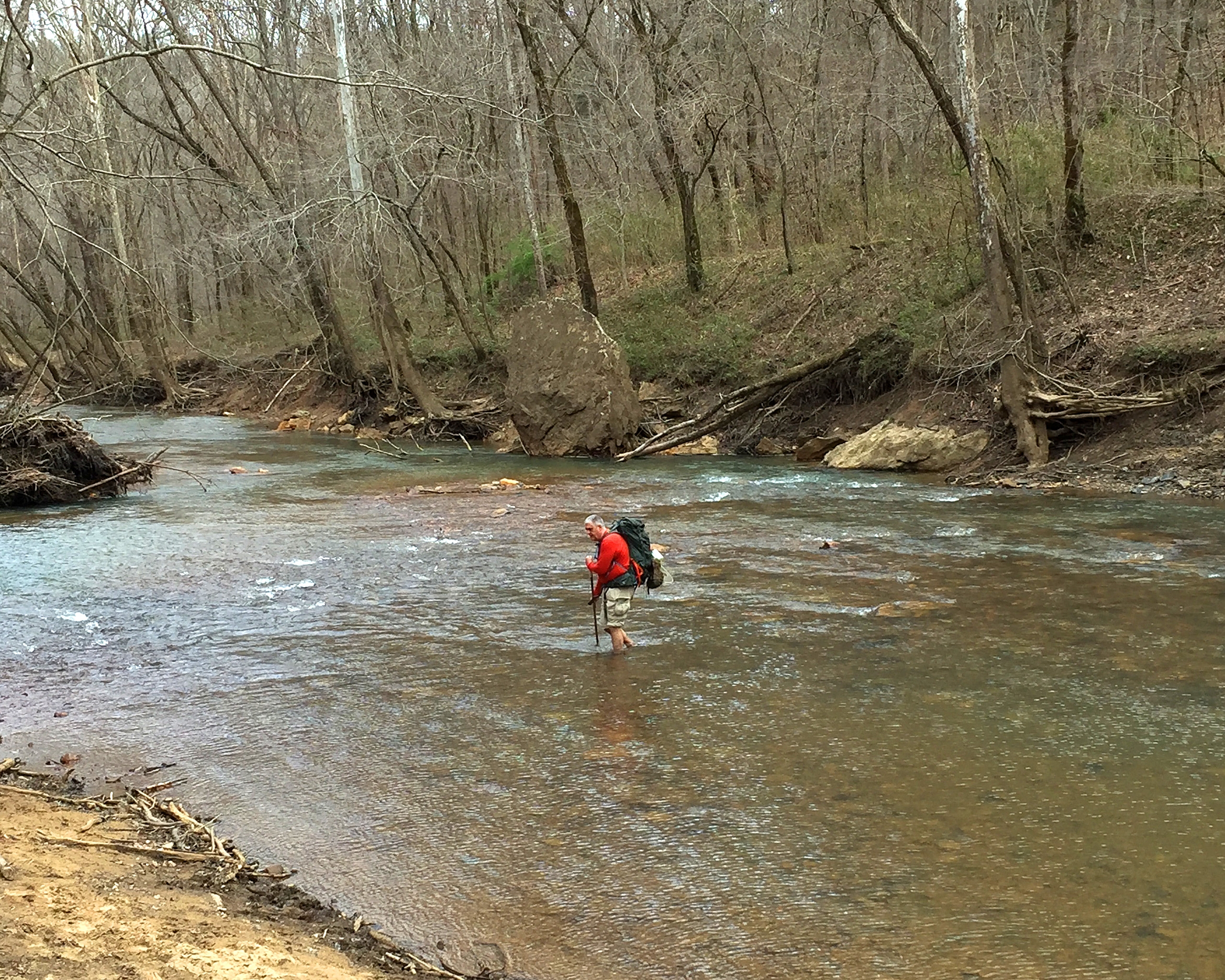
With some foresight, running out of water should not be an issue. There are numerous stream crossings, lakeshores and occasional convenience stores along the route. To be safe, plan on filtering all water (with the possible exception of convenience store bottled water).
Resupply Options
Resupply opportunities are fairly convenient along the trail with 60 miles being the farthest distance between possibilities. The STA is active and there are a couple stretches where arrangements can be made for association members to bring a resupply box to you on the trail. The city of Morehead is right on the trail and McKee, Livingston and Whitley City are nearby. A full list of resupply options is on the STA website.
Closing Thoughts
The best place to start researching Sheltowee Trace is at the STA website. The association is active and seemingly filled with southern hospitality. The group appeared eager to help hikers with the challenges of the trail such as shuttles and even delivering resupply boxes.
Make no mistake—this trail is a challenge. However, the parks and National Forest it travels through are beautifully rugged with scenery and vistas you wouldn’t expect to find outside of a major mountain range.
Looking for a new way to thru-hike a trail? Try the Hiker Challenge. The Sheltowee Trace Association has set up a program where a hiker can complete the trail by hiking one weekend a month for 11 months. All shuttles, camp locations and camaraderie are provided for you; all you need to do is show up, hike and enjoy the show.

This website contains affiliate links, which means The Trek may receive a percentage of any product or service you purchase using the links in the articles or advertisements. The buyer pays the same price as they would otherwise, and your purchase helps to support The Trek's ongoing goal to serve you quality backpacking advice and information. Thanks for your support!
To learn more, please visit the About This Site page.

Comments 32
Great write up jim? Hope all is well, Thank you for sharing the trail with me✌
Thank you, Jim. I’m newer to hiking and typically follow my adult kids on some of their adventures. I’m doing the Sheltowee Trace Challenge 2017 and am SAVORING my weekend experiences that have had exceptional support! Since I have 5.5 years until my retirement, weekend challenges are GREAT! Excellent write up!
Marcia,
The Challenge is a great way to hike the trail, the support is perfect for a newer hiker and the weekend bites of mileage add up fast. Glad to hear you are enjoying it.
David,
Thanks for the nice words. All is well; it was a great hike.
You have inspired me to keep at it. I have a burning desire to do a thru-hike, and had plans to do the ST a couple of years ago, but then some surgeries put that out of the question. I suffered from trail withdrawal for 2 years! Now, I’m back, and slowly adding mileage to my short day backpacking trips. I hope to be able to do a thru-hike next year, and will be seeking advise from everyone! I have done many sections of the ST and I LOVE IT!!! The AT will probably never happen for me, but I am likely to add some of those shorter long trails to my trail bucket list. I plan to check out your website as well. Thank you for writing.
Thanks for your comments. Not everybody can, or even wants to, thru-hike the AT, PCT or CDT. For those folks, there are a lot of great hiking alternatives. The ST is a great shorter “long” trail with a lot of support from the Sheltowee Trace Association. It sounds like you have a solid plan to build up to the ST next year. Good luck!
How does the Sheltowee Trace stack up to the other trails you have done?
As I’m sure you know, what is the best trail will be in the eye of the beholder. As I grew up in southern Ohio, Sheltowee Trace has a lot of the same climate, flora and fauna that I’m used to. So for me, the ST is more comfortable, but maybe less exciting than the others. However, here’s a few areas of comparison.
1. Hiking is often easier on the ST than the others I’ve done. The Long Trail is steeper and rockier. JMT, Colorado Trail and Tahoe Rim Trail all have elevations over 10,000 feet. There are some steep sections of the ST, but they are relatively short.
2. One negative is the ST has more road walking than the others. As a relatively new trail, there are still sections being moved off road, so that is getting better all the time. On the flip side, if an emergency happens, you’re never days from a bail out option.
3. Resupply options are fairly regular on the ST. Your pack can be lighter than the western trails where town stops were often 80-100+ miles apart. Water can be a major concern out west too.
4. For me, the spectacular mountain scenery of the Rockies or Sierras is hard to beat. By contrast, the ST has beautiful green eastern forests much of the way. Additionally, Big South Fork, Red River Gorge and Natural Bridge are pretty impressive in their own right.
5. All the trails are somewhat easy to follow and navigate. That’s not to say I was never lost, but I was able to get my bearings back without too much time lost.
6. Assistance along the trail was very good of every hike. Local trail support groups love “their” trail and are happy to help others experience it. The ST does stand out in this regard with the option in a couple spots to have a resupply package delivered to you on the trail.
Hopefully this info helps. Each trail definitely has its appeals, but personal priorities will determine the best hike for each person.
Hey Jim,
Great write up. I was wondering if you had a favorite section of the trail? I’d love to do a few section this summer and looking for the highest quality one’s.
Alex,
For my money, the southern end of the trail is the best. The trail is within Big South Fork National River and Recreation Area and there are impressive overlooks with beautiful streams and rock formations throughout. The first 55 miles (from Burnt Mill Bridge) also do not have any significant road walks. That’s a big plus for me.
Something else to consider within Big South Fork is that there are quite a few other trails in the park and loop hikes are possible.
Hiking by Cumberland Falls and the Red River Gorge was another highlight, but my favorite section is still Big South Fork.
Getting ready to do a small section hike of the AT in the Shenadoah National Forest. Good to know that are some other good trails a little closer to home. I am a little concerned about the stream crossings as I am not a swimmer and would be concerned about depths much higher that my knees, especially with a pack on my back. How high is the water usually? I would be aware of seasonal variations, but some rough idea would be great.
Thanks
Aliece,
As you said, seasonal (and even single rainfall) variations are hard to predict. On my hike, I changed into my “water” sandals more than a few times, but I didn’t encounter any crossings that threatened to knock me over. Mid-calf is the highest I recall where there was any current. It got to my knees on one crossing, but there was no current at that point.
As you’ve probably heard, It’s a good idea on stream crossings to unbuckle your hip belt and make use of trekking poles (more points of contact). Some hikers will also band together and cross streams in a group formation as well.
Through the years, I’ve had a few sketchy stream crossings so I know where you are coming from. On my hike on Sheltowee Trace though, I had no issues.
Take care.
Hi Jim. Just wondering how popular this trail is. I like meeting people along the trail from time to time, but not constantly and certainly not having lots of people in the campsites at night. Is there opportunity for quiet and bein alone for long periods? Thanks !
Tom,
As you have probably guessed, crowds are going to vary quite a bit depending upon the section of the trail and when you go. For example, right now (July 4 holiday) at Cumberland Falls or Natural Bridge State Park the trails are extremely busy with both day hikers and weekend backpackers. Any summer weekend around the more popular destinations can be busy though. Red River Gorge is very popular with backpackers.
Generally speaking though, I did not find the trail to be crowded at all. When the trail isn’t in National or State Parks, it is often in National Forest which allows for disbursed camping. I never had an issue with crowds where I wanted to camp. A few times there were other groups in the area, but most of the time we camped by ourselves.
If you are looking for solitude, I think you can find it here much of the time. Fall is a great time on the trail for many reasons, including the lack of crowds. Weekday hikes from October all the way through April should provide all the quiet you’re looking for.
Never heard of it! Thanks for the great bit of info.
Some nice scenery.
I’ve added it to my maybe list.
Glad you liked it.
Take care.
Nice write up. Also an Ohioian here planning on doing a 3-4 day hike in September, any suggestions for entry/exit points? The map looks pretty limited for that length of hike…
Another fellow Ohioan here, was going to try to do a 3-4 day hike in September, any suggestions on entry/exit points for a hike of this length? Could probably cover 15 miles a day…Any suggestions would be great!
My first thought would be a hike near the southern terminus, in Big South Fork. It’s my favorite section of the trail. Starting at Burnt Mill Bridge (Mile 319) and heading north, 45 miles will put you near the Divide Road crossing (Mile 274, parking nearby) Check the STA website for help on getting a shuttle.
If you don’t need to be on Sheltowee Trace for all your miles, there are countless loop options utilizing other trails in the park. In that case, Bandy Creek Recreation Area might be a good starting point. An eastern loop provides some big views. A western loop can take you near quite a few natural arches. An interesting hike either way.
Good luck. September is a great time to hike there.
Hi Jim. Great post on the Sheltowee. Can you tell me how many miles of the trail are road miles, how many road mile sections there are and the longest stretch of road miles? Thanks, Mike
Mike,
In round numbers, about 75 miles are on road (including gravel, forest service roads). There are maybe 20 road walks with most being 1-3 miles in length. There are a few long ones that are a pain including a 16 mile, a 7 mile and three around 5 miles long. Over time this will decrease as they are actively working to get more of the trail off road.
Take care,
Jim
This is great information. Thank you Jim.
Mike
Hi Jim.
I’m following up on the road mileage information that you provided to me. Do the maps available for purchase indicate where the road mile section locations and their lengths are? If not, are there other resources with this information available to help our group in planning a trip?
Thanks, Mike
Hi Jim,
I’m following up on the road mileage information that you provided. Do the maps that are available for purchase indicate where the road mile sections (along with their respective lengths) are located on the trail? If not, are there other resources that can provide this information to help our group in planning section hikes?
Thanks,
Mike
Mike,
The map sets that are referenced in the article do show the road sections and the mileages pretty well. You shouldn’t have any trouble figuring out where, and how long, the road walks are. Good luck with your hikes!
Jim
The maps are pretty good. The northern terminus is mile 0 and the southern is mile 323. Every mile is marked on the map. It’s also easy to tell whether a section is trail, forest service gravel road or a public road. Looking at the map, you can tell exactly where you leave a trail and join a road, then see the road walk distance before returning to trail.
Thanks Jim. Your information is a big help.
Mike
Hi Jim.
Several of us plan on making the Sheltowee our go to hike and complete it in sections over the next few years. We’ve hiked the first 25 miles from the Northern Terminus to Morehead and noticed the lack of open areas to camp after we left the shelter house on the private property 10 miles in from the northern trail head. I’m looking to purchase a two person tent with a fairly large footprint, and I’m concerned about adequate locations to pitch it as we progress south on the trail. I’m sure that with a little diligence, we will be able to find locations, but I would appreciate your thoughts on campsites before I make the purchase. Thanks for your time and help. Mike
Mike,
As it’s been a few years since I’ve been on several sections of the trail, I’m probably not the the best source to talk about individual campsite specifics. Generally speaking, you should be fine, though I don’t know what your daily hiking distance will be. A good starting point might be to go to Sheltoweetrace.org and look at the section: Trace Notes. These notes split the trail up into weekend sections, provide turn by turn directions and locate some of the campsites along the trail. If there’s a specific section you’re concerned about, there’s contacts on the site that should be able to help as well.
Good luck. It’s a great trail.
what is the approximate amount of “road walk” miles on a thru hike of the Sheltowee?
In round numbers, you are looking at about 75 miles of road walk, including gravel and forest service road. Most road sections are 1-3 miles though a few are 5 miles and one is around 16 miles.