 ">
">
How To Hike the Pemi Loop: 30 Miles of Premier Hiking in New Hampshire’s White Mountains
The Pemi Loop is one of the most infamous backpacking routes in the northeast. While Backpacker Magazine rates the loop as the second hardest day-hike in America, most hikers shudder at the thought of traversing 29 rugged miles in a single day and instead spread the hike over multiple nights.
And why not? One could spend an entire day just sitting at the summits and taking in the vistas of spectacular ridgelines and tranquil wilderness. This guide will help you plan out the logistics of your trip, and give you an idea of what to expect on this magnificent journey.
Pemi Loop At a Glance

A user-generated map from CalTopo showing a possible 4-day Pemi Loop itinerary. Original here.
Distance: 29.3 miles
Elevation Gain: 9,000 feet
Estimated Completion Time: Can be done in one day, but most take 2-4 days
Location: In and around the Pemigewasset Wilderness in New Hampshire’s White Mountain National Forest
Best Time to Hike: Late June to early October
Trail Type: Loop
Scenery: Frequent summits and exposed ridgeline at high elevations, beautiful boreal and hardwood forest at lower elevations
Terrain: Very difficult: includes rock scrambles, ladders, and steep climbs
Navigation: Appalachian Mountain Club Map 2: Franconia-Pemigewasset, or FarOut: Pemigewasset Region
Why Hike the Pemi Loop?
In 30 miles, hikers will experience almost every type of scenery the White Mountains have to offer. Exposed alpine ridges, meandering streams, and boreal forest line most of the Pemi Loop.
The route passes over eight 4,000-foot summits and skirts close to four more, so intrepid peakbaggers can check off a quarter of New Hampshire’s 48 high peaks. Many of these peaks are regarded as some of the state’s most spectacular — each one is much more than just a box to be checked off a list.
Planning and Preparation
Getting There
The Pemi Loop is easy to reach. From I-93, take Exit 32 for Lincoln, NH, and drive 6.5 miles east to the Lincoln Woods Trailhead. Parking costs $5/day and often fills up, but overflow parking is available along the Kancamagus Highway.
Direction
The Pemi Loop can be hiked in either direction, but most hikers choose to venture clockwise. That way, you get the big climbs of Franconia and Garfield ridges out of the way early and save the long, gradual descent down Bondcliff for sore legs.
Climate

A June snowstorm makes the trail above treeline very treacherous
The weather conditions along some sections of the trail can be extreme and unpredictable. Higher summits frequently experience hurricane-force winds and thunderstorms in all months of the year. They can also experience snowstorms between early September and mid June, though the worst conditions are usually between late October and late May.
Keep an eye on the Mount Washington Observatory Higher Summits Forecast online, and check forecasts in person at AMC campsites and huts. On good weather days, temperatures reach up to 70 degrees on the summits and up to 90 in the valley, although it’s usually a little cooler.
Gear Suggestions
Be sure to pack the 10 essentials of backpacking gear, especially extra layers and a headlamp. Conditions can be extreme in the Whites, even in summer. In the winter, snowshoes, crampons, and an ice axe are recommended for many sections.
READ NEXT – A Common-Sense Guide to the 10 Essentials
Pemi Loop: Step by Step
Beginnings

Crossing the East Branch Pemigewasset River at the beginning of the Lincoln Woods Trail
The Pemi Loop begins on the Lincoln Woods Trail, a straight, wide, and flat backcountry superhighway. Remnants of the area’s past as a hub for logging are still visible with many railroad ties and artifacts dotting the path.
While this is one of the least exciting sections of trail, appreciate the relaxing grade while you can: it’s about to get a lot steeper.
After 1.4 miles, turn left onto the Osseo Trail. This trail climbs 3,000 feet up to the summit of Mt. Flume in 3.9 miles. It’s steep and steady, with some ladders along the way providing a warm up for what will come. The summit is rocky and exposed, with excellent views of the next section: Franconia Ridge.
Franconia Ridge

Franconia Ridge from Mt. Lafayette
From the summit of Mt. Flume, you’ll follow the Franconia Ridge Trail for the next 4.6 miles. Descend a steady but reasonable 400 feet into one of the ridge’s saddles before climbing 500 feet to the summit of Mt. Liberty. This involves some short, steep sections, but generally traverses the ridge at a moderate angle. The views from Liberty’s summit are fantastic, showcasing all the ridgelines, rocky summits, and meandering valleys that you’ll hike on the rest of your journey.
After 0.2 miles, you’ll reach the junction with the Liberty Springs Trail; another .3 miles down this trail leads to its namesake tentsite. This is the last designated campsite and reliable water source on the trail until Garfield Ridge Campsite, 6.6 treacherous miles later. You’re about to hike through the second longest stretch of alpine zone in New Hampshire, where camping is illegal and weather can be severe. If you’re tire or there’s any sign of thunderstorms, it’s best to stop here.
At this point, the Pemi Loop runs concurrent with the Appalachian Trail. It’s marked by white blazes, but these will soon be replaced by stone cairns as the trail climbs above treeline.
The true start to the alpine zone comes shortly before the peak of Little Haystack Mountain. The Franconia Ridge Loop day hike joins the trail here, so expect heavy crowds from here until the summit of Mt. Lafayette. This is one of the most popular day hikes in the Northeast, and those crowds, combined with Pemi Loopers and AT thru-hikers, make for quite a bit of congestion.
There’s a reason for the popularity, though. This part of the trail is often compared to scenery in the Lord of the Rings, with steep drops on either side of a defined ridgeline. Here, you’ll pass over Mt. Lincoln and Mt. Lafayette, the only 5,000-foot peaks in New Hampshire outside of the Presidentials.
Garfield Ridge

The Garfield Ridge Trail in a nutshell
After leaving the summit of Mt. Lafayette, the trail will suddenly become much quieter as you continue along the Garfield Ridge Trail. The trail drops 1,500 feet steeply as you reenter the boreal forest.
On a topographical map, the six-mile section between Lafayette’s summit and the Galehead Hut doesn’t seem too bad, but don’t be fooled. While it only shows one climb of 800 feet to Mt. Garfield’s summit, the trail actually traverses countless pointless ups and downs (PUDs). These include many rock scrambles and make the trail very slow going.
That said, the summit of Mt. Garfield is actually quite nice, offering panoramic views of the Pemigewasset Wilderness, the Presidentials, and beyond. A foundation of an old fire tower provides refuge on gusty days.
Unfortunately, the descent down Mt. Garfield is arguably the most difficult and technical section of the entire Pemi Loop. Shortly after passing the Garfield Ridge Campsite, the trail travels directly down a waterfall. Be careful to descend slowly to prevent any slips.
The slog continues for another 2.5 miles until the Galehead Hut. The hut offers a refuge from the elements with treated water and toilets free of charge. The Croo here also sells delicious baked goods, snacks, and the 10 essentials to help you recharge and ensure you’re prepared for the rest of the hike. They also offer overnight lodging: more information in the camping section.
For peakbaggers, Galehead Mountain is located 0.4 miles away from the hut on the Frost Trail, and is a relatively easy walk for anyone looking to check the 4,000 footer off your list. The summit is completely wooded and has no view, but there is a vista off of a small rocky outcrop nearby.
Twinway

How the Twinway looks the entire way between Galehead Hut and South Twin
Leaving Galehead Hut, follow signs for the Twinway. It begins with a 1,200-foot vertical climb over just 0.8 miles to reach the summit of South Twin. While this is the last major climb for clockwise hikers, it’s also the steepest sustained ascent of the whole loop. While it’s very steep, it’s also well maintained with rock steps most of the way. You’ll be able to use your trekking poles as there are very few sections where all four limbs are needed.
At the summit of South Twin, be sure to give yourself a pat on the back. You’ve now completed all the major climbs of the whole loop, and the next 13 miles are relatively easy compared to what you just endured. The view from here is beautiful, and the trail will now meander over high-alpine bog bridges. Alternatively, peak baggers can hike one mile each way to the summit of North Twin, which provides decent views and another check off the list of 4,000-footers.
After three miles, the Twinway meets a junction with the Bondcliff Trail. To continue on the Pemi Loop, stay to the right, taking the Bondcliff Trail and leaving the Twinway and Appalachian Trail. However, peakbaggers may want to continue along the Twinway for 1.2 miles to the summit of Zealand Mountain, which offers no view.
The Bonds
Immediately after beginning the Bondcliff Trail, you’ll walk through a scrubby field devoid of trees on a false summit of Mt. Guyot. While the true summit of the mountain is only a tenth of a mile down the Twinway Trail, the shoulder that the Pemi Loop passes over has better views. Furthermore, despite the summit’s elevation of 4,580 feet, it doesn’t count as one of the 48 4,000 footers because it doesn’t have enough prominence (doesn’t rise high enough above the saddle of South Twin).
Half a mile past the junction, you’ll pass the spur to Guyot Campsite, which contains a shelter that sleeps 12 along with several wooden tent platforms. There’s also a good water source here.
From Guyot Campsite, begin your ascent of Mt. Bond. It’s only about 350 feet of elevation and is significantly easier than most of the other peaks you’ve climbed so far. Along the way, there is a 0.5-mile spur trail to West Bond Mountain.
Peakbaggers will be sure to make the journey, but I’d recommend everyone hiking past to do so as well. West Bond has one of the best views in the White Mountains and is absolutely worth the relatively short trip. If you’re staying at Guyot campsite, it’s a great spot to watch the sunset.

Descending Mt. Bond, looking towards Bondcliff
Mt. Bond has another excellent, panoramic view. You can see everything you just hiked in the past few days, along with sweeping views of the Bondcliff ridge. You might even remark about how uncrowded it is. While most 4,000-footers with a spectacular view are swamped with people on most good-weather days, the Bonds manage to stay relatively tranquil.
That’s because the trifecta of peaks are some of the most isolated in the state. The shortest trek that traverses each of these peaks is over 20 miles long, keeping most day hikers away.
After taking in the views on Mt. Bond, continue towards Bondcliff. The trail very briefly enters the treeline, before reemerging on the descent on a wind-scoured ridge that continues to offer spectacular views. Shortly, you’ll reach Bondcliff, the last peak of the loop. A gigantic cliff face lies on the west side of the ridge. It’s a great photo opportunity, but be careful: it’s a long drop to the valley below.

The iconic cliff face of Bondcliff
The Final Descent
As you begin the descent, you’ll scramble down a short rock face, though it’s much less technical than the scrambles you faced on Garfield Ridge. Beyond this short section, the descent is very gradual for the next four miles, when you once again reach the East Branch Pemigewasset River.
At this point, the trail is a mental game. You’re likely tired and exhausted, and the next five miles are flat, wide railroad grade just like the very beginning. Three miles before the finish, you’ll cross a bridge, leaving the Bondcliff Trail and the Pemigewasset Wilderness and rejoining the Lincoln Woods Trail.
Slowly, the trail becomes more and more crowded with day hikers reeking of perfume and shampoo. The sounds of cars rushing down the Kancamagus Highway will be music to your ears shortly before reaching the bridge across the river, bringing your spent legs back to the parking lot.
Alternative Routes
One of the beauties of the Pemi Loop is how flexible the route can be. While the Lincoln Woods Trail is the standard starting point, any one of the many side trails can be used as the “stem” of the route. Some other options include the following:
Extra Peaks
- Galehead Mountain (4,008 ft): 0.8 miles round trip from Galehead Hut
- North Twin Mountain (4,675 ft): 2.2 miles round trip from South Twin Mountain
- Zealand Mountain (4,253 ft): 2.4 miles round trip from Bondcliff Tr/Twinway junction
- West Bond Mountain (4,540 ft): 1 mile round trip from Bondcliff Trail

The summit of Zealand may not have a view, but at least it has a cool sign.
Semi-Pemi Loop
The so-called Semi-Pemi is a variation of the loop where hikers complete either half of the loop before cutting down the middle on the Franconia Brook Trail. This can be a much easier hike and is a common bailout route for hikers who realize they are in over their heads when attempting the whole thing.
The western Semi-Pemi goes over Franconia Ridge and Mt. Garfield, taking a total of 23.8 miles with 6,200 feet of elevation gain. The eastern Semi-Pemi passes over the Bonds and South Twin, comprising 24.3 miles with 4,850 feet of elevation gain.
Camping
Due to the popular nature of this route, camping is limited to designated sites, with the exception of the Osseo Trail and the Franconia Ridge Trail between Mt. Flume and Mt. Liberty.
Designated campsites cost $15/night and are first come, first served. They can be very overcrowded on weekends, so try to arrive early. These include:
- Liberty Springs Tentsite (mi. 6.5)
- Garfield Ridge Campsite (mi. 13.1)
- Guyot Campsite (mi 18.2)
The Appalachian Mountain Club also maintains two huts near the route, which offer multi-course meals, hostel-style lodging, and interpretive programs. Advanced reservations are strongly recommended. These include:
- Greenleaf Hut (mi 9.7, 1 mile away from route)
- Galehead Hut (mi. 15.6)
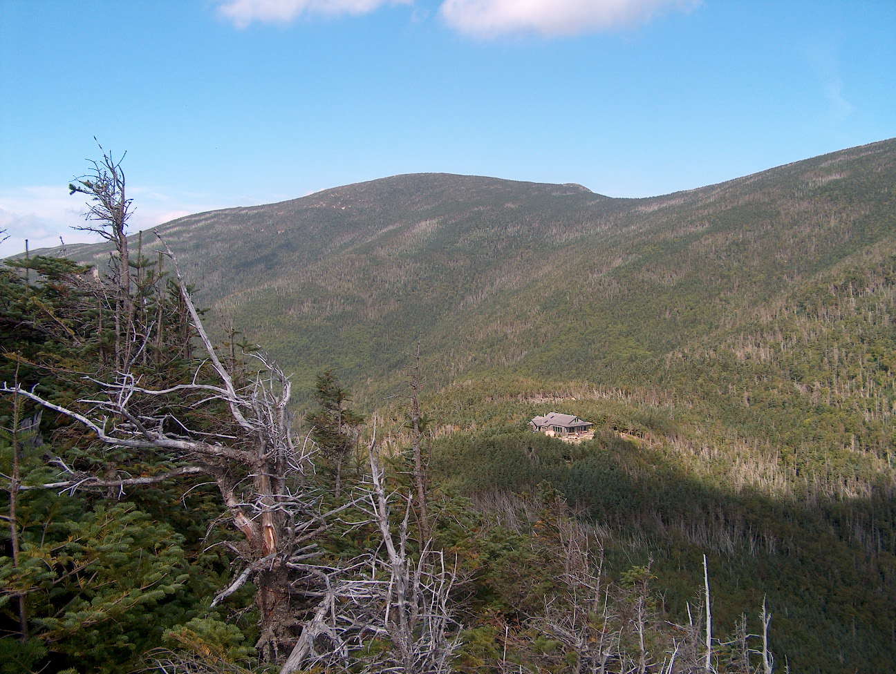
Galehead Hut from a viewpoint near Galehead Mountain
Water
As the trail traverses ridges for most of the way, water can be very limited. All water sources, with the exception of the huts, should be treated before drinking. Here is a list of water sources:
- Liberty Springs Tentsite (mi. 6.5)
- Greenleaf Hut (mi. 9.7, 1 mile away from route). There’s also an unreliable spring 0.2 miles down the trail, on the way.
- Garfield Ridge Campsite (mi. 13.1)
- Reliable stream (mi. 13.4)
- Galehead Hut (mi. 15.6)
- Guyot campsite (mi. 18.2)
- Many stream crossings, Bondcliff trail (mi 21.8-24.6)
- East Branch Pemigewasset River (mi. 0-1.4, 24.6-29.3)
Closing
The Pemi Loop is one of the best backpacking trips in the northeast. Its long, treacherous climbs make the spectacular views feel even more amazing. Whether you’re looking for a fast-paced weekend getaway or an unhurried week-long trek, the loop will be the trail for you.
Featured image: Brian Garner photo. Graphic design by Zack Goldmann.

This website contains affiliate links, which means The Trek may receive a percentage of any product or service you purchase using the links in the articles or advertisements. The buyer pays the same price as they would otherwise, and your purchase helps to support The Trek's ongoing goal to serve you quality backpacking advice and information. Thanks for your support!
To learn more, please visit the About This Site page.

Comments 2
Nice overview of the Pemi Loop. I’ve hiked it a number of times, most recently a few years ago. As a certified Old Fart, i took 4.5 days and four nights. I met a trail runner who was training to do the whole thing in less than 24 hours. At this point, i’m more into Slowest Known Times. But good for them.
My most recent hike was counterclockwise. Having started late in the day, i camped the first night near the south terminus of the Bondcliff Trail where it meets the Wilderness Trail. It’s an undesignated, but often-used site.
The article mentions it, but it’s worth reiterating that the few hundred feet on the steep waterfall/trail east of Garfield is a good reason to consider a counterclockwise hike so one would be going up that thing rather than down.
Also, you might consider scheduling your hike so you do the Franconia Ridge section on a weekday. It’s one of the most popular day hikes in the Whites, and it can be a bit of a mob scene up there on weekends.
This is a carefully written, accurately detailed description of the Pemi Loop. Good stuff, Brian!