Maine, Part 1
For NOBOs like myself, Maine is the end of the trail. Crossing that final state line is bittersweet.
Leaving Gorham, NH, I had high hopes that the trail would become more gentle. Of course, I knew two obstacles awaited: Mahoosuc Notch and Mahoosuc Arm. But somehow, somewhere, I had been lulled into thinking the trail would be different (translate easier) than what New Hampshire had dished up.
Never have I been so wrong.
New Hampshire was the training necessary for Maine. Seriously, I have no idea how SOBOs survive and continue after Maine. I have a new respect for those who make it through and continue south.
Plenty of YouTube videos, books, and online articles focus on Mahoosuc Notch and Katahdin, but I don’t recall seeing anything about the section of trail from Gentian Pond Shelter to Full Goose Shelter, the resting point just before Mahoosuc Notch. That little 9.6-mile stretch took me a full 11 hours to traverse. Steep ups and downs, a couple of boulder fields and the occasional muddy bog made me wonder what was in store for the remainder of the trail.
Friendly climbs a section of steep trail between Gentian and Full Goose shelters.
Up until the White Mountains I had been putting in some big miles. I hoped to return to that same mileage in Maine but my biggest mileage day didn’t come until the 100-mile wilderness! (More about that in my next post.) I could usually look at the elevation chart and predict how long a section would take. Maine tossed that all out the window.
Rebar ladder…
…followed by a huge wooden ladder.
Mahoosuc Notch
They refer to it as either the “hardest mile on the AT” or the “most fun mile on the AT.” I call it both.
One solid mile of boulders–most the size of a car and some as big as a school bus–that hikers get to climb over, around, and sometimes under. The only time I felt anxious was going through the caves. They were never long but some were very tight, requiring that I remove my pack and drag it along behind.
Some advice for the notch…
A few words of advice for anyone who has yet to traverse the notch–follow the blazes and arrows. They really do point the way through the path of least resistance. And definitely travel with friends or tramily. There were times in the notch when I needed a boost or a hand and also a few times when I needed a word of encouragement. Mountain Goat, Ranger Rick, and Friendly provided all of the above as well as a huge dose of humor to ease the sting of how truly difficult this section was for me.
Mountain Goat removed his pack to make it through a cave crawl. We all followed suit.
How long did it take?
This one-mile section took me 2 hours and 45 minutes. I’m willing to bet Mountain Goat could have done it faster, but we were glad he joined us 20 minutes in and stuck with us to the end. We all sat at the north end and enjoyed a well-earned rest and lunch as a very fat chipmunk entertained us with his “please give me food” antics. This spot also had the best, clearest, coldest water I had seen anywhere on trail.
Mahoosuc Arm
So, once you get through the infamous notch, you get to climb for another mile-and-a-half up Mahoosuc Arm which is as steep as a 60-degree angle for a good portion. The top includes a nice spot to rest and enjoy the views (if the weather cooperates) and then…more alpine bogs and mud. But, hey, it’s not like I wasn’t used to mud and bogs!
Did it get any easier?
Well, either the trail became less ferocious or I rose to the challenge. Perhaps a little of both. But easier is a relative term. Of course, I’m just referring to Maine up until Monson and the 100-mile wilderness. There were days upon days of rain, resulting in oh-so-much-more mud.
Miss Janet sighting
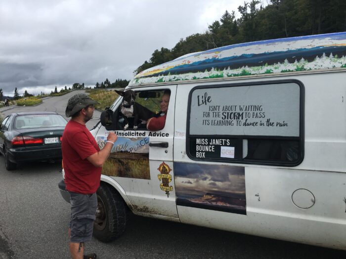
Then days upon days of sun followed, allowing me to dry out. Surprisingly, a fun thing happened at Height of Land–I ran into Miss Janet! The last time I saw her was in Erwin, Tennessee, and her friendly chatting was as welcome as the Dr. Pepper and snacks she was handing out.
Miss Janet chats with shuttle driver Rodney at Height of Land.
The photo on Miss Janet’s van is exactly the view (at right) of Mooselookmeguntic Lake.
Gorgeous views once again
Once the sun came back, the views were spectacular from every mountain. The wind must have been in my favor as there wasn’t any smoke from the Canadian wild fires–just lakes and mountains as far as I could see.
This ladder was a little sketchy but it worked.
Maine is definitely the water crossing state. I was glad that I had traded out my camp shoes for my Keen sandals back in Massachusetts.
Water crossings
In Maine, most of the water crossings do not have any kind of bridge to assist hikers across the sometimes deep and dangerous brooks/streams/rivers. I happened across a group of trail volunteers who were still working to repair damage from the 26 days of rain in June that flooded the state, and I asked about the lack of bridges. After all, the other states have lots of bridges–some small and unobtrusive, blending into the environment, and others large and grand. I was told that Maine winters are too harsh for bridges to remain intact. Hmm. This is curious to me as there were bridges over water crossings on a large section of side trails on ATC lands in the Gulf Hagas region in which we had to walk a “high water detour.” More about that in the next blog.
Black bear footprint. I was considering a tent site until I saw this. I opted for a shelter (with lots of people around) instead.
Holy cow! I hiked 2,000 miles!
Hiker shoes drying out at the Maine Roadhouse hostel–a sure sign that the weather has been very wet.
Fellow hikers
I haven’t said a whole lot about the people I met along the way. Perhaps because I never really had a “tramily” in the true sense of the word. My hiking pace was either too slow or too fast for others (mostly too slow) and I often made a few acquaintances that lasted a week or so, and then they disappeared.
In Maine, folks I hadn’t seen for weeks or even months seemed to pop up along the trail or at hostels. The reunions were brief and sweet. Some I caught up to because they had taken a few days off. Others caught up to me. However it happened, I was glad to see so many again because…Maine is the end of the trail. It is highly likely I will never see most of these trail friends again. When that realization hit, I started taking more photos of the people rather than the sights.
I’d trust most of the hikers I met with my life. Hikers are a different breed of human–they’ll do everything they can to help out a fellow hiker whether it means giving away a meal or a band-aid, sitting with an injured hiker as they wait for help, or making space for 10 in a shelter built for six just because it’s raining.
Hikers have restored my faith in humanity.
Some of the amazing people I hiked around for months, including Watermelon, Gucci, WitchDoktor, and Squirt.
The square base of a former fire tower at the top of Avery Peak in the Bigelow Mountains.
I love it when I come across a historical sign on the trail.
The perfect tent spot at Pierce Pond.
I was extremely happy to see this bridge! It wasn’t much, but it was all I needed for a safe crossing over some deep water. They need more of these in Maine, especially in the 100-mile Wilderness.
The Kennebec River
Between the FarOut App and signs on the trail, I knew the Kennebec River was one water crossing that was absolutely not to be crossed by fording.
All warnings explained that a dam (25 miles upstream) releases water causing rapid changes in water depth and current. The canoe “captain,” Greg, explained that the dam releases water at 10 am daily and it reaches the AT crossing after 2 pm, which is one reason why the ferry service stops at that time.
The service was free, but the app said that “tips are appreciated.” I hope Greg was able to buy a cup of coffee with my tip.
My ride (the dot in the middle) across the Kennebec River was the canoe service that runs from 9 am to 2 pm daily during the summer.
Almost to the top of Moxie Bald.
Almost to Monson. I never did see Bigfoot.
This website contains affiliate links, which means The Trek may receive a percentage of any product or service you purchase using the links in the articles or advertisements. The buyer pays the same price as they would otherwise, and your purchase helps to support The Trek's ongoing goal to serve you quality backpacking advice and information. Thanks for your support!
To learn more, please visit the About This Site page.


Comments 2
I really enjoyed your synopsis of Maine, which I hiked NOBO late July- early August. Maine really is essentially just as grueling as New Hampshire, but without the hospitality of the huts, and with more bogs, roots, and mud. I especially concur with your reflections on the difficult 10 mile stretch between Gentian Pond and Full Goose, for which there were no “warnings”. I kept asking, “why is this section not infamous?” I suspect the answer is that Mahoosuc Notch, the very next day, steals all the thunder. While many fellow hikers were big fans of Maine, I confess that it felt like a very long chapter at the end of a very long book that would have benefited greatly from some editing! My favorite part of Maine were its many beautiful lakes and ponds, which were perfect to swim in and camp alongside.
Best wishes for getting through the 100 mile wilderness, and moreover, for navigating Baxter’s crazy camping logistics. That part almost makes summiting Katahdin seem easy!
You are 100% correct in your description, that Maine is just as tough as NH but without the hospitality of the huts! By the time I reached the Bigelows, I was burned out and wondered if I could even finish. Those lakes and ponds definitely brightened my mood!
Thanks for your comments!