 ">
">
My Phone May not Survive 2,650 Miles
Long before my first smartphone, I owned a “personal digital assistant.” I bought a PDA because I was tired of keeping a pile of post-it notes. So many scraps of paper, each one containing a smudged list written in my barely legible scrawl. My first PDA stopped working after about two years. It waited until I was ten days into a two-week vacation before refusing to accept any input via the touchscreen. My itinerary and booking details were all still in there, I just couldn’t get to them. Fortunately, I was able to remember enough of the information to finish the trip without major inconvenience.
Both of my subsequent PDAs lasted about two years, but my first smart-ish phone had much better longevity. It survived for six years before its battery malfunctioned on the final day of a backpacking trip. Coincidentally, my digital camera and step-counter died that same day. My current phone will be about two years old when I start the PCT. So far, its only sign of old age is a hit-or-miss fingerprint sensor.
I’ll be Heading SOBO
I’m starting my hike at the end of the first week in July. I was originally intending to go NOBO, but my internet connection had problems on October 29 and I couldn’t get a permit. On January 14, I was placed at the back of the queue and I again missed out on a NOBO permit. When the time comes for me to head south, I’ve decided not to rely exclusively on my phone for navigation. I’ll use Guthook’s PCT guide, but I’m also taking my Garmin GPSMAP64 loaded with a map of the PCT. The Garmin is several years old, but it’s demonstrated that it can survive getting wet, dropped, and sat on.
If You Haven’t Already
You should check out Halfmile’s PCT maps. If you’re concerned about unreliable tech, the obvious answer is to use a physical map. Halfmile’s website contains plenty of other information such as trail notes, elevation profiles, and GPS data. I downloaded it all, but had some problems using the GPS data on my Garmin. The problems weren’t caused by the GPX files, but by the limitations of the GPSMAP64. After a few adjustments to the files, I was able to get them to work. I also updated them to make life a little easier for a SOBO hiker:
- mile-markers increase as you head south and are grouped into section-specific routes;
- waypoint descriptions are displayed;
- the elevation plot shows your progress left to right.
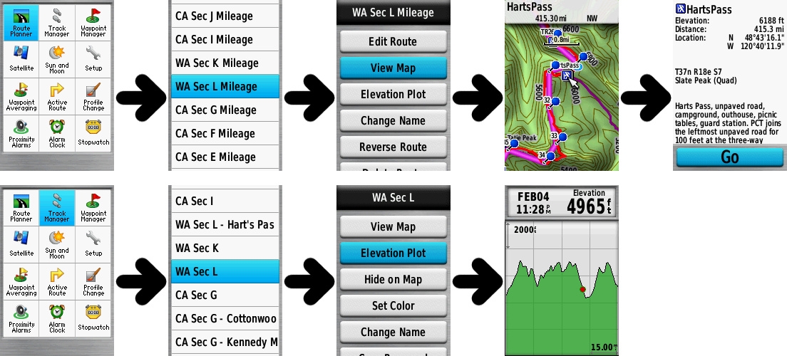
Halfmile’s GPS data displayed on a Garmin GPSMAP64.
In theory, the functionality of these SOBO-specific GPX files isn’t limited to the GPSMAP64. However, it’s the only handheld I’ve verified them on. I also checked that the files work in Google Earth. If you decide to use the files, please verify that they work on your particular device before hitting the trail. You can find the files here (scroll down past the NOBO data).
Another Useful Website
For tracking distances in general, rather than the PCT specifically: gmap-pedometer. I haven’t yet found a mileage-tracker with the same variety of base maps to choose from.

Some of gmap-pedometer’s base maps.
Having traced a route, it’s possible to zoom in, screen-shot each piece of the map, and then join the pieces into a single image. The map can be copied to a GPS device (Garmin instructions here) after some time-consuming georeferencing. One more obstacle to overcome with the Garmin is its file-size limit. It may be necessary to cut the map into sections or reduce the JPG quality.
If you’re willing to go without the underlying map, gmap-pedometer has the capability to generate just the route/track that you’ve traced. You can copy the data into a GPX file and send it to your device without the hassle of georeferencing, file-size limits, etc. Unfortunately, using this approach, you don’t automatically get mile markers.
Let me know in the comments if you use a mileage-tracking website that does output GPX mile-markers. I’d also be interested to hear if your preferred mileage tracker has functionality you haven’t been able to find elsewhere.

This website contains affiliate links, which means The Trek may receive a percentage of any product or service you purchase using the links in the articles or advertisements. The buyer pays the same price as they would otherwise, and your purchase helps to support The Trek's ongoing goal to serve you quality backpacking advice and information. Thanks for your support!
To learn more, please visit the About This Site page.
