 ">
">
Sierra Part 1: Kennedy Meadows South (Mile 703.4) to Bishop via Bishop Pass (Mile 832.2)
Reflection
It is truly difficult for me to write about the high Sierra in a way that sheds light on the grandeur of the landscape, the challenges of hiking through the snow, and the intensity of each moment. My plan was to journal daily like I had in the desert, but from the minute I crawled inside my tent, exhaustion usually took over. I did manage to write some stories in real time, others I captured through photos, and some stories, well, will be engrained in my mind for a long time to come.
I felt lucky to start my Sierra trek with a team of five people that I met on day one or two of the PCT. Pursuing this journey with a group that I already trusted gave me the confidence I needed to take those first steps out to the trail.
Part one of our journey was ambitious. My team decided to do one push from Kennedy Meadows South (PCT Mile 703) to Bishop via Bishop Pass (PCT Mile 832), instead of taking the more popular bailout over Kearsarge Pass (PCT Mile 790). This decision resulted in a 14-day food carry (read: about 28 pounds of food and bear canister alone).
PCT Day 43 / Sierra Day 0 – Head Start
2.4 Miles: Kennedy Meadows General Store (Mile 703.4) to Kennedy Meadows Camp (Mile 705.8)
I weighed my backpack using the scale at the Kennedy Meadows General Store before we started hiking our “easy” few miles into the Sierra as a head start for day one. 50lbs the scale read. I cringed and tried not to think about how my backpack was only rated to carry 40lbs. I had never attempted to carry a pack nearly this heavy, and I was about to try for the first time in the snowy Sierra. I fought to keep my wits about me as we talked to other hikers who were also packing their bags for the Sierra. The vast majority of hikers were cramming ten days of food in their bags for a planned bail out over Kearsarge Pass. The more I looked at my overstuffed backpack, the more crazy it felt to take on these extra days. Fourteen straight days in the snowy Sierra… what could go wrong?
“That was the hardest I’ve worked on the PCT so far,” I said somewhat jokingly and somewhat serious after the flat 2.5 miles to our first campsite of the Sierra.

The Sierra Team hiking into camp on day 0.
On the hike in, my heart rate felt too quick, my shoulders were crushed by the weight of my backpack, and I felt like I was barely moving as we hiked. “Tomorrow is going to be… interesting,” I thought to myself before falling asleep.
PCT Day 44 / Sierra Day 1 – The Climb into the Sierra
17.7 Miles: Kennedy Meadows Camp (Mile 705.8) to Campsite Among the Snow (Mile 723.5)
“I am brave!” I said as I hoisted my backpack up onto my thigh before transferring it onto my back. I could no longer throw my backpack onto my shoulders with ease… putting on my backpack was now a whole production that involved deep breaths, new mantras, and oftentimes, curse words. I still couldn’t believe how heavy my backpack felt weighted down with snow gear, extra warm clothes, and two weeks of food.
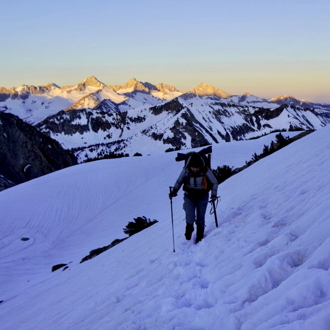
We hiked as a team, taking breaks every hour to remove the weight from our backs. Hiking break to break was the only way to tackle this day. It felt eerie hiking up and up on the dry trail knowing that snow fields awaited us. Near the end of our day, we finally saw our first patch of snow! The guys all ran over and climbed onto the snow slightly off trail, obviously excited.

First snow sighting of the Sierra!
Snow blanketed the trail quickly after. I was disoriented immediately navigating through the snow covered landscape to find a dry spot that resembled our camp spot. We found a dry patch among the snow to set up camp. Tomorrow would be our first morning in the snow. I felt exhausted, sore, and intimidated, but ready for our Sierra experience to truly begin. I fell asleep by 8:00 p.m. and started snoring (so I was told) immediately.
PCT Day 45 / Sierra Day 2 – New Reality Sinks in
14 Miles: Campsite Among the Snow (Mile 723.5) to Group Campsite with Hail (Mile 737.5)
I woke up at 2:00 a.m. and packed up my tent. I put crampons on my boots for the first time before we started hiking in the light of my headlamp. My pack felt lighter with my crampons on my feet instead of carrying them, but my feet were already killing me. I was breaking in new mountaineering boots that were compatible with semi-automatic crampons. Every time I took a step, the front of the boot dug into my lower shin – disincentivizing every step. The area was definitely bruised, and I needed to figure out how to hike through the pain. I took three Advil to get through the morning miles until I could assess the area further in the light. At lunch time, I cut a square from my 1/8 inch foam pad and taped it over the bruised area with leukotape. Improvising solutions was going to be key out here since there was no easy access to towns when something goes wrong.

Our first snowy morning and 3:00 a.m. start
Mid snowy traverse it dawned on me… I left my entire bag of tent stakes at the camp site. It was finally sinking in. We had barely entered the Sierra, but I was already realizing how alone we were out here. No cell service. No bailout points for days. We hadn’t seen a single other group of PCTers yet. If something went wrong – we fixed it the best we could and moved on until the next obstacle.
PCT Day 46 / Sierra Day 3 – Getting Past the Breaking Point
14.5 Miles: Group Campsite with Hail (Mile 737.5)
Chicken Spring Lake (Mile 752)
“It’s already hard and we haven’t even done any of the passes yet,” I thought to myself as I slogged through the soft snow. Carrying 50 pounds is hard. Hiking in the snow is hard. Waking up at 2:00 a.m. is hard. The boys I’m hiking with are faster and stronger. Comparison is hard, but I am strong too though.
“The Sierra will break you down physically and mentally and emotionally…” Spud said, recounting a blog he read about hiking through the Sierra on a high snow year. “BUT when you get through it, you will feel superhuman.” We were hiking the last 0.6 miles up to our campsite at Chicken Spring Lake. It was thundering, starting to hail, and we were slogging through slushy snow on mile 14 of the day.
“I needed to hear that,” I replied. “It’s not supposed to be easy…” I thought to myself. And with that perspective, I picked up pace to a breakneck speed of 1.5 MPH up to the lake. When I got to the lake, I started crying happy/proud tears (this would become more and more common). We made it to the lake, the storm passed, and I overcame my first truly taxing snow hiking. Today was hard but we did it.

Chicken Spring Lake
PCT Day 47 / Sierra Day 4
15.6 Miles: Chicken Spring Lake (Mile 752) to Whitney Portal (Mile 767.6)
“Over 15 snow miles today… and water crossings… can we really do that?” I asked the team as we filled up water at a stream just as the sun was starting to rise. To make it to the Mount Whitney portal, we needed to push some bigger miles today. I started to notice my negative self talk and doubts about making miles in these harsh conditions. I didn’t know my limits yet. Could I really do this?
I tried to stay positive through the miles all day. One step at a time was really all I had the capacity to worry about while hiking in snow. I did eventually hit a groove. We were making our miles, and as we got closer and closer, I realized we were going to make it to the portal after all! After our last climb of the day, we got a clear view of Mount Whitney for the first time. I stood there staring at the mountains that surely looked further than a day of hiking away. We would be standing at the very top of that mountain tomorrow morning. It didn’t sink in. We glissaded down the last big decent before arriving at camp with Mount Whitney towering above us.

Our first clear view of Mount Whitney (the round mountain on the right!) before glissading down.
PCT Day 48 / Sierra Day 5 – Mount Whitney
17 Miles: Whitney Portal (Mile 767.6) to Mount Whitney Summit to Whitney Portal (Mile 767.6)
My alarm went off at 11:30 p.m., which felt offensive. But it was Mount Whitney summit day! It felt surreal to be at the base of the Mount Whitney, about to hike through the snow to the top of the tallest mountain in the lower 48. We had been keeping an eye on the weather after experiencing a few hailstorms on previous days, and our weather window looked perfect.
Snow covered many of the rocky switchbacks, and we had to navigate safe routes in the dark. We hiked through the night until finally, around 5:00 a.m., we could make out the outline of the mountains surrounding us. I was already awestruck by the views. Then, after almost seven hours of climbing, I could see the summit hut in front of me. I burst into tears. On a 300% snow year, I summited the tallest mountain in the lower 48. That was pretty cool.

The Summit of Mount Whitney!
The day wasn’t over though, and I have learned to never underestimate the route down. In the morning we climbed up some pretty steep snow with our crampons. Going down… we were going to have to be even more careful. Spud instructed me through down climbing, using the pick of my ice axe to secure myself to the slope, and digging the toe spikes of my crampons into the snow to climb down backwards, like a ladder. Learning this mountaineering technique was fun and also helped to boost my confidence in the snow.

Down climbing a snowy slope on the descent from Mount Whitney.
When we got back to camp, I was exhausted and happy – the best feeling. I crawled into my sleeping bag and looked up at Mount Whitney before falling asleep for the afternoon.
PCT Day 49 / Sierra Day 6 – River Crossings & Forester Approach
11.1 Miles + extra miles for three river crossings: Whitney Portal (Mile 767.6) to Forester Approach Campsite (Mile 778.7)
Today was daunting. Our goal? Three water crossings and getting as close as possible to the infamous Forester Pass. Forester Pass was the first high Sierra pass and well known for a sketchy traverse across an ice chute before reaching the tallest point along the PCT.
We forded through Wallace Creek right after sunrise, which motivated us to hike fast to warm up afterwards. When we got to Wright Creek, we walked up and down stream looking for a log, snow bridge, or safe place to cross. We saw someone approaching us from the other side. Their group had an “incident” at this river crossing the day before, he said as he tipped us off to a safe log crossing downstream. We later found out that one of their hikers fell in the river and lost a boot, leaving him stranded in the middle of miles and miles of snow. Later that day, we saw a helicopter flying overhead and we joked that new boots were on board (spoiler… new boots were in fact on board.) This was a stark reminder of how remote we were and how high the stakes were out here.
By the time we got to Tyndall Creek, just the thought of searching up and down stream for a crossing was exhausting. We walked upstream since the trail followed the river on the other side anyway, searching for a snow bridge that may or may not exist. When I saw the thick snow bridge, I smiled so big before walking over. “Thank you snow bridge!!!” I said before we started navigating back toward the trail.

Tyndall Creek below as we climb the approach to Forester Pass.
We slogged up the snow with the Forester Pass ice chute looming above us. We were tired and had a big day tomorrow; it was time to look for camp. Our campsite criteria included water, flat (ish) ground, and ideally dirt. We beelined to a pile of rocks to examine the situation. It was one of the most beautiful spots I had ever set up a tent. And unfortunately… one of the windiest (funny how that works). We all secured our tents to prepare for a long windy night ahead before our early wake up call.

A photo that Spud took of our tents lined up on the patch of rocks.
PCT Day 50 / Sierra Day 7 – Forester Pass & Exhaustion
12.6 Miles: Forester Approach Campsite (Mile 778.7) to Glen Pass Approach Campsite (Mile 791.3)
I woke up energized by straight adrenaline. I packed up and examined my tent. We experienced about 35MPH winds the night before, and in the middle of the night I had heard something snap. As I took down my tent, I saw that a tent pole did, in fact, snap clean in half. This was going to need to be a post Forester Pass problem.
Over the last few days, sleep was minimal, but we were crossing off huge milestones. We began hiking up the pass while looking for boot tracks (which we never found). I trusted the toe spikes of my crampons to hold me in the ice as we climbed straight up. When I reached the first rocks and switchback, I looked down at what I had just climbed, and I started shaking. “Just keep staying calm…” I thought to myself as we continued climbing from snow to rock to snow up the switchbacks and towards the ice chute. When we made it to the top, laying eyes on the ice chute traverse was a crazy feeling. And what was crazier? I felt fully prepared and confident to cross it.

Traversing the Forester Pass ice chute.
We all made it across the chute and ran up the remaining snow free switchbacks to the pass high point. I heard Taut shouting as he rounded the corner, and I got butterflies thinking about what the other side must look like. I rounded the bend and saw the craziest clouds and sunrise that I have ever laid eyes on, and from the high point of the Pacific Crest Trail. This was a moment I will never forget.

Sunrise from the top of Forester Pass.
I rode the adrenaline high throughout the descent from Forester before hitting a wall. I felt absolutely drained mentally and physically as our sleepless nights and intense morning caught up to me. I took a nap during our quick lunch break and woke up feeling even worse, but we had to push to the approach of our next pass (this was becoming one of the tricky things about the Sierra schedule, there was always another pass to get to). As we neared camp, my legs gave out every 30 steps or so, causing me to fall in the snow. I was barely keeping it together. I made it to camp and all I wanted to do was sleep. Taut and Spud helped me fix my tent pole that snapped in the wind the night before. I successfully pitched my tent and staked it out for another windy night. I sat in my tent force feeding myself dinner. To my surprise, I hadn’t been hungry in days, which scared me because I definitely needed the calories. I realized how powerful our mind can be in survival mode, blocking out certain cues from our minds.
I overheard Spud and Detour talking. “I’m just so proud of everyone,” Spud said. “A month ago, you guys had no snow experience and now you are pulling off technical passes in the Sierra. I didn’t realized these passes would be so hard and so technical.” I fell asleep exhausted and scared and excited and proud all at the same time.
PCT Day 51 / Sierra Day 8 – Glen Pass
9.6 Miles: Glen Pass Approach Campsite (Mile 791.3) to Suspension Bridge Camp (Mile 800.9)
I woke up after more than eight hours asleep and felt slightly more prepared to tackle our day. I grabbed my boots and felt how cold and hard they were… they were frozen. I tried sliding on the frozen boot and panicked when they refused to slide on like normal. I started to tear up, emotions still very accessible from the day before.
I took a deep breath (and three Advil), jammed my feet into my boots, packed up camp, and started hiking. My legs felt shaky. I had lost a lot of confidence on the snow yesterday afternoon, and it was time to gain it back before going over Glen Pass this morning. I climbed the pass, slow and steady, and I felt my mind and body starting to work together once again.
Getting my feet back under me and gaining back my confidence on Glen Pass!
We spent the rest of the day in a beautiful valley hiking around the Rae Lakes and navigating mostly off trail due to water crossings. We ultimately decided to end our day early, stopping at the Woods Creek suspension bridge, saving the full Pinchot Pass ascent for the morning to continue our new good habit of getting enough sleep. When we got to our campground before the suspension bridge, we ran into groups of other hikers that were stalled. The bridge was actively being repaired and closed for the rest of the day… possibly into tomorrow. We kept an ear out to see how this would affect our morning. I ran over when I saw the construction worker cross the bridge with scissors! “A ribbon cutting ceremony!!!” I screamed to the boys. As I watched the employee ceremonially reopen the bridge, I felt lucky that our schedule was unaffected by this closure. I fell asleep by 6:30 to prepare for our early morning climb.
PCT Day 52 / Sierra Day 9 – Pinchot Pass
14.2 Miles: Suspension Bridge Camp (Mile 800.9) to Mather Pass Approach Campsite (Mile 815.1)
“You kinda have to make peace with the idea of death out here,” I thought. “Every decision has a calculated risk associated.” It was 3:00 a.m., and we just got to a snow bridge over the raging Woods Creek. This snow bridge was our best route option. There is an accepted risk to cross on any snow bridge. At some point, every snow bridge will collapse, and you don’t want to be on it when it does. If this snow bridge collapsed, and I fell into the water… I would get swept away and likely not survive. In the off chance I got out of the water, the sun didn’t rise for another three hours and I’d likely be hypothermic.
We all assessed the thinner than ideal snow bridge; it was a team decision to proceed or not. I strapped on my crampons to have more traction to walk up to the snow bridge and jump over the middle (the most vulnerable part), and we each took turns crossing. I thought about that calculated risk for the next few hours. I was unable to shake the weight of that decision.
During the seven-mile climb I was distracted by buzzing thoughts about the dangers of the Sierra and what level of risk I was willing to accept. I turned around at one point and saw the glowy sky. This was my absolute favorite part of every day. That pink sky mesmerizes me. I may not have been able to understand my existential thoughts in that moment, but I sure was happy to be alive, hiking, and in this exact moment and place.

The sunrise during the approach to Pinchot Pass, about 2 hours after crossing the snow bridge.
PCT Day 53 / Sierra Day 10 – Mather Pass
14.6 Miles: Mather Pass Approach Campsite (Mile 815.1) to Grouse Meadows (Mile 829.7)
Mather Pass was our last technical pass of the high Sierra, where we needed to find a route up the steep snow, scramble up two rock patches, and climb up and over the cornice. We got to the base of the pass and stopped to consider our options. We could faintly see some boot track, and we decided to follow it and reassess our options as we climbed. We got to the first rock scramble just as the sky got glowy. We climbed up the rocks and made a decision about the next steps of our route. We still had boot track to follow! I took careful steps, one at a time, in the ladder like boot track up the steep slope and eventually up and over the cornice. “Wow,” I thought to myself after staying calm and collected while climbing Mather Pass. “The boot track certainly helped, but I’ve come a longgg way since day one of the Sierra.”

Climbing Mather Pass
We had a long descent into the valley for the rest of the day. And for the first time, in a very long time, we enjoyed a few dry stretches of trail! I quickly learned not to expect much from “dry” or “flat” sections of trail yet… we spent a lot of effort climbing over blowdowns and avoiding the river that the trail had become. BUT it sure felt nice to see the trail when we could.
We planned to camp at Grouse Meadows and when we arrived, we saw that Grouse Meadows had become Grouse Lake! It had been fascinating seeing the impact of the high snow year on the lower elevation parts of trail. We set up camp on dry spots next to the meadow and enjoyed the beautiful reflecting pond “meadow” with towering mountains surrounding us.

View from our Campsite
PCT Day 54 / Sierra Day 11 – Bishop Pass
11.5 Miles: Grouse Meadows (Mile 829.7) to the Bishop Pass Blue Blaze (Mile 832.2) to Campsite by Long Lake (9 out of 14 miles)
It was up and out day! We had just 2.5 PCT miles to get to our bail out blue blaze. Getting to town was not as easy as it was in the Desert. We needed to hike 14 miles up and over Bishop Pass to a trailhead then road walk down and find a hitch to Bishop.
Knowing this pass was “bonus miles” definitely made it harder to tackle mentally to me. We enjoyed some dry switchbacks before getting to a challenging water crossing. We worked as a team to find a route over the many branches of the waterfall/river by jumping between rocks and downed trees. As we continued up and up nearing the snow field and pass, a way of anxiety hit me. Between the switchbacks, snow patches, river crossing, icy bridge crossing, and navigating snow fields… I was completely overstimulated and needed a minute to decompress. I sat on the side of the trail and tried to calm down… we still had the bulk of our day ahead of us.

The broken and icy bridge we crossed after crossing the lower part of this waterfall earlier in the day.
I knew we were so close to completing our Sierra expedition part one, but for some reason, that didn’t make continuing easier. The weight of the last 11 days was now sitting squarely on my shoulders. I realized how excited I was to get into town and actually process the events of the last 11 days. This uneasy feeling stuck with me until we got to our campsite, four miles from the exit to town. I felt relaxed knowing we could sleep in and after a short morning descent… we were out.

Our final decent to Bishop Pass Trailhead
PCT Day 55 / Sierra Day 12 – Bishop
4 Miles: Campsite by Long Lake (9 out of 14 miles) to Bishop
I woke up to a soft light. We slept in! We only had four miles to get to the Bishop Pass trailhead and then we were officially headed to town! On the hike down the valley, we passed weekend hikers (what a concept after the last few weeks of solitude!). We chatted with a few groups and they congratulated us on our journey thus far as we hiked by them. I had been so hyper focused on our route the last few weeks, that it felt good to zoom out. For the first time, I realized that our journey really was a remarkable accomplishment. I hoped that heading into town would bring the perspective that I needed to give myself credit for persisting through the hard times even while struggling in the moment.
The Sierra is harsh and unforgiving, but hiking through it is one of the most rewarding things that I’ve ever done.

We arrived at the Bishop Pass trailhead! After this we road walked and got a hitch down to Bishop to resupply and rest in town!

This website contains affiliate links, which means The Trek may receive a percentage of any product or service you purchase using the links in the articles or advertisements. The buyer pays the same price as they would otherwise, and your purchase helps to support The Trek's ongoing goal to serve you quality backpacking advice and information. Thanks for your support!
To learn more, please visit the About This Site page.

Comments 3
I enjoyed your detailed blog. What an accomplishment. Congratulations!
This is freaking epic. Awesome work everyone, and thanks for documenting your journey, Rachel!
So impressed. I wasn’t sure any “normal” PCT hikers would make the Sierra in the normal time frame this year, and assumed almost everyone would have to skip it or flip-flop. Congratulations!