 ">
">
Te Araroa Side Quest: Taranaki Around the Mountain Circuit
The thing about volcanoes is that if you’re not used to having them around, they’re really hard to ignore. I had a week to wait until Rob and Ellyse caught up with me on the trail, so I decided to take the bus over to the west coast of the North Island to explore Taranaki, the volcano I’d been gazing at on the horizon.
If, like me, you’re used to your local mountains being hundreds of millions of years old, it can be a bit shocking to learn how quickly volcanoes are formed, and how young some of them are. Taranaki is the newest in a series of volcanoes that have emerged in the region over the last 20 million years or so – but the crazy thing is how quickly each of these peaks has either collapsed or eroded, forming a chain of jagged lumps and crags that march in a straight line northwest out to the Tasman Sea. Taranaki itself was first formed in eruptions about 125,000 years ago, but its cone has collapsed at least once since then and then been rebuilt with the detritus of later explosions. The current cone is about 4000 years old – which is NOT OLD in my book – and, since I know you’re wondering, it last erupted in 1755. At present, it’s considered dormant – but I’m guessing there are official volcano-minders somewhere keeping an eye on it just in case.
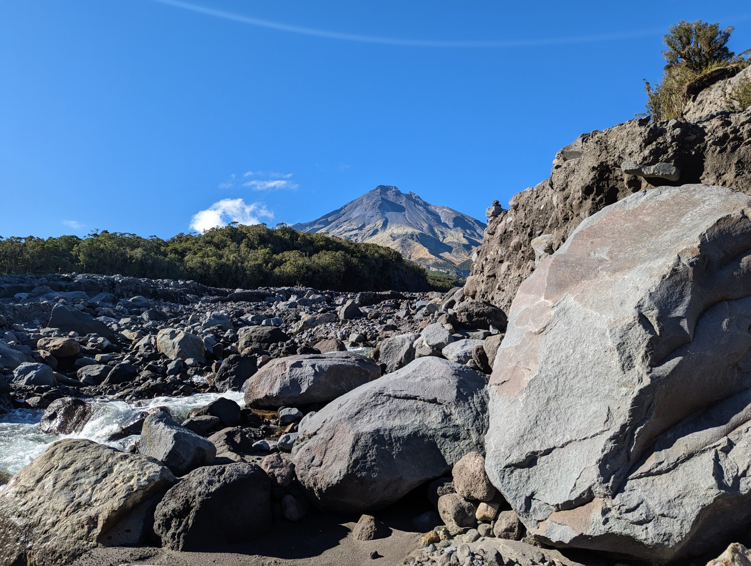
Taranaki and the Stony River
There are a number of hiking trails in Taranaki / Mt. Egmont National Park, but I decided to follow the Around the Mountain circuit, which is essentially a 4-day loop with options to follow either a high or a low route and with access to a spur track up to the summit. A funny thing about the national park is that it’s nearly a perfect circle, owing to a decision back in the 1880s to create a forest reserve within a 10-kilometer radius of the summit. So now the volcano and its park look like an island marooned in a vast patchwork ocean of dairy farms and sheep ranches stretching across the plain.
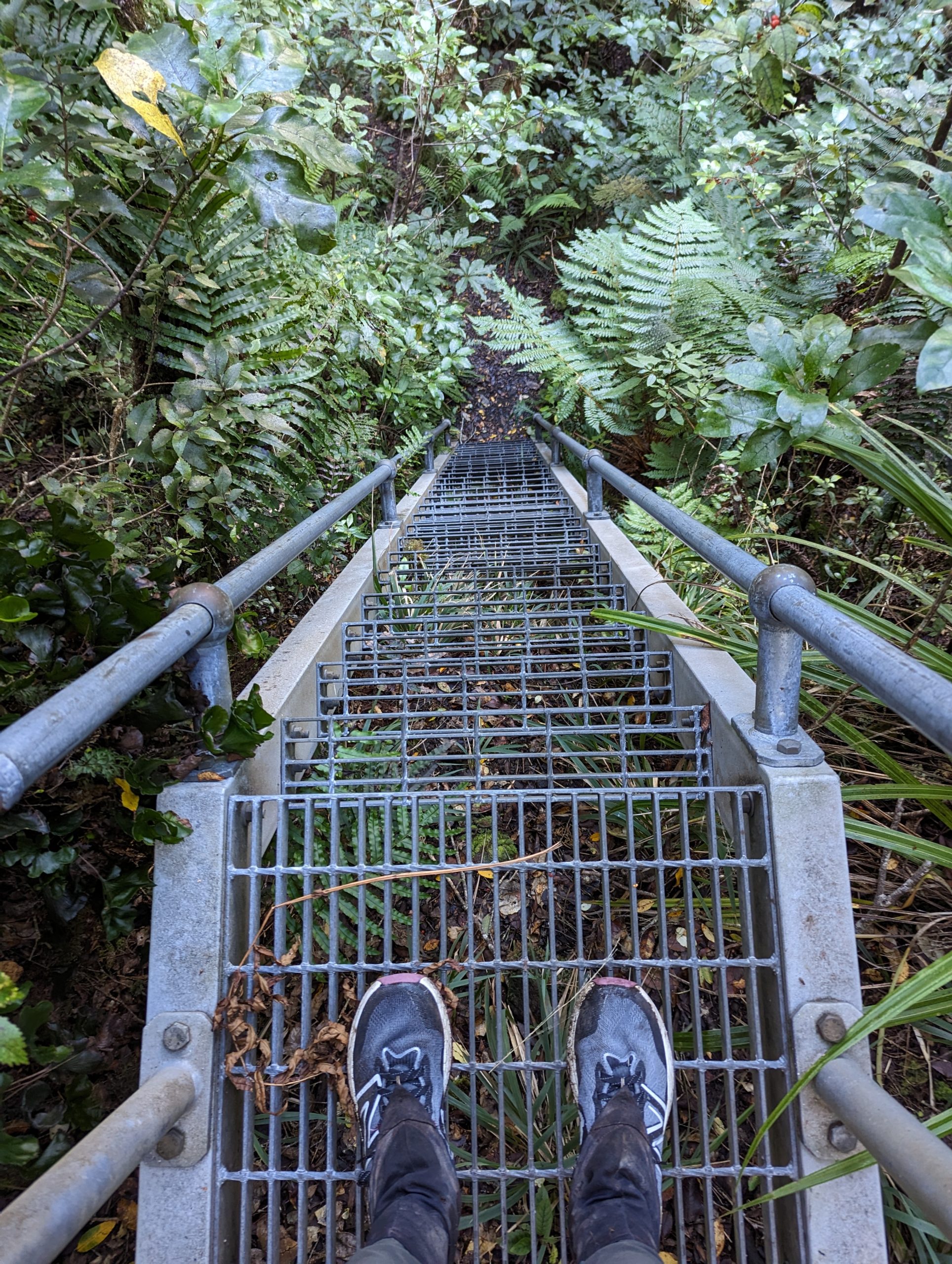
As I learned over the course of my hike, some of the trails in the park are heavily used and, perhaps consequently, well-maintained (or maybe the cause-effect relationship is the other way around, but at any rate, what I’m trying to say is that there are parts of the park with other hikers and good trails). Aaaand… there are places where it looks like DOC has bowed out and is letting nature take its course, and everyone who knows what it’s like in there is staying far far away. By which I mean that I spent one day skipping down a spectacularly constructed trail, complete with steps, bridges, and boardwalks, and then two more days bush-bashing across ravines and crawling over massive treefalls, and then one more day of the steps and the ladders and such. More about the ladders in a minute.
But first – this mountain gets an unbelievable amount of rain. Like, over 6 feet of rainfall a year. All falling on steep slopes made largely of loose debris. So there’s a pretty impressive amount of erosion, and you can see that the land is just getting cleaved away chunk by chunk every year. Little trickles near the peak become forceful rivers as they descend, carving away ravines and depositing debris in rocky outfalls that shift and move as currents change. I really can’t imagine how difficult it must be to maintain this kind of a landscape for human visitors, and I imagine DOC must have some kind of triage system whereby factors such as “earth being eagerly consumed by ravenous forces” and “nobody seems too keen to go back here anyway” are plotted on an official rubric, prompting a management strategy best described as “stand back and let the mountain eat itself.”

Bells Falls
All of which meant that on my days of bush-bashing around the back of Taranaki, I had the place to myself. The best night came after a day of sliding down gullies, climbing cliffs of gnarled roots, and circumnavigating enormous fallen trees blanketed in vines, to emerge finally at Lake Dive, a little lake nestled at about 3000 feet, just below the steep upper slopes of the mountain. There used to be a hut here but it burned down in 2020 and hasn’t been rebuilt, so I’m guessing not many people make the journey. Incidentally, I’ve learned that huts burn down if not frequently then at least occasionally – wood stoves, gas cookers, and candlelight all making for uneasy companions in these tin and timber shacks. So it was just me, a patch of charred earth, and an amazing view of the volcano’s peak across the lake.

View of Taranaki across Lake Dive
Ah, right – back to the ladders. Imagine, if you will, a nearly trackless forest, looped about with vines and moss-shaggy trees, sudden swamps and cliffs of mud. Imagine battering your way through this place and then coming to a 30-foot-tall metal ladder bolted to the side of a chasm down which you must climb. Imagine thinking, “Yes! This is gonna be so much easier to get down than that 50-foot chasm I had to slide down on my ass a mile ago!” Then imagine wondering, upon reflection, who gets to decide which chasms are outfitted with metal ladders and which are fated to be polished by the asses of hapless people sliding down them. Every time I came to one of these ladders I was filled with an inexplicable glee – it felt like finding the remains of an alien spacecraft in the jungle somewhere. Behold: someone once thought it was worth spending a bunch of money and effort to help people climb up this cliff in the middle of the woods! THANK YOU, annual budgets of the long-ago past!

This website contains affiliate links, which means The Trek may receive a percentage of any product or service you purchase using the links in the articles or advertisements. The buyer pays the same price as they would otherwise, and your purchase helps to support The Trek's ongoing goal to serve you quality backpacking advice and information. Thanks for your support!
To learn more, please visit the About This Site page.

Comments 7
I keep thinking the landscape photos can’t keep getting better, but somehow they do.
As a local to Taranaki, the Round the Mountain circuit was very much a jewel in DOCs crown when they opened it proper a few years ago. Unfortunately, a lot of the erosion you saw was exacerbated by Cyclone Gabrielle back in Feb this year, and so a decision was made in the last few weeks to leave any repair works until at least next summer, as not very many people attempt the circuit from this point onward in the year 🙁 .
Glad you got to see how beautiful our maunga is, even if it required some bush bashing. Best of luck with the rest of Te Araroa!
there 5 million people in NZ, … the department of conservation which runs that park has stuff all money to maintain the tracks that as you see erode a massive amount and take a massive about of work to be maintained… a lot of nz forest is basically jungle and overgrows tracks at massive rates plus a lot of erosion.. and now with climate change the weather is getting worse, damaging the tracks far more than usual.
foreigners all come to NZ and expect the same standard of track as they have in europe or america…. aint gonna happen, there just isnt the tax money to go around and the population is low and so are the no of volunteers. no shortage of people wanting to hike on our trails but a big shortage of people wanting to maintain them..
its estimated only a third of TA hikers are paying the TA fee or the department of conservation hut fees.
the no of tourists in NZ has exploded, the dept of conservation have been roped in to building high quality tourist walks that take a massive amount of their resources away from maintaining other hiking trails.
if you think about it you realise just how lucky some countries are to have so much resources put into maintaining hiking trails… a lot of NZ trails its pretty common to loose the trail because its not well maintained and you have to rely on decent navigation skills and persistance to stay on the trail…
the TA is getting worse because of the lack of resouces available, initially it was given $ 5 million to get it up and running but since then, stuff all money has gone into the track and the no of hikers has gone through the roof with no increase in people maintaining it… mud is getting deeper and deeper, in places thigh deep…. hut toilet s are getting full.. huts are getting more wear and tear and not being repaired. everyone wants to hike but only a few people want to do track maintenance… or pay anything towards the tracks… things are only going to get worse… most TA walkers are from overseas and have little interest in the future maintenance of the track once they have walked it.. eeryone wants to complain and few are going to do much about the problems.
That view was amazing! Glad your persistence keeps paying off. Gotta keep remembering that it’s “November” there too.
It feels like November in central Pennsylvania right now too haha! Happy to hear from you. Keep at it!
Your wry sense of humor and entertaining dialog keep me coming back for more. Thanks also for the pictures of the beautiful scenery!
Shari, all I can say is WOW! Your trek is just an absolutely amazing, life changing experience. I’ve just been bing reading your posts and just loving your witticisms and all the details. I’m so happy you are having such an amazing time, experiencing so much, and meeting great people along the way!
I’ve loved all the narratives, friend! Had to comment here on your musings of ladders and years-gone-by budgets…as someone steeped still in the logics of institutions and bureaucracy, my immediate reaction was: Someone must have died on the chasms that got the ladders.
Thanks for the lifeline of sanity your posts have proffered!