 ">
">
Trail Update Number Nine
Washington!!!

Cue this eighties masterpiece.
Things felt different.

Usually as I leave a town, I feel a bit uncertain, almost as if all of my experience and lessons have been forgotten and I am learning how to live on trail again. Maybe it’s the idea of leaving a comfortable place, parting with friends and being “out there” again. Maybe it’s the fear of forgetting something or getting something wrong that could cause me difficulty when I’m three days from anything. Maybe it’s just that I feel tired and sore and need more rest. Whatever the case, every single time I walk away from civilization I have the feeling of excitement about what is to come mixed with trepidation about what I’m leaving behind. But not this time! As I walked out of Cascade Locks, Oregon I felt a new sense of confidence and sense of urgency. After crossing the Bridge of the Gods, I was completely excited. The end was in sight! Sure, five-hundred miles is still a long ways to go, but after fifteen-hundred already traveled, it seemed relatively easy. Yes, I knew that there was a lot of tough terrain ahead of me. And the aches and pains that used to disappear after a good night’s sleep or a zero day were now a constant companion. But after having been through so much, I knew how to deal with pretty much anything and I was ready.

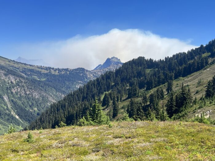
Washington provided an excellent welcome. The first few miles were on relatively easy terrain and the trail was lined with ripe blackberries on both sides. I had to consciously tell myself to keep moving lest I make no miles and do nothing but feast! Then the honeymoon ended. The trail ramped up and kept going up. I had inconveniently forgotten that I had been at sea level (or barely above it) and was now climbing back up into the Cascades. In the first ten miles we gained almost four thousand feet. Ouch. After which, we promptly dropped about two thousand. Demoralizing. And thus the pattern would remain for the entirety of the section. Long climb, followed by long descent. Barely any flat ground. The first two days were almost entirely in a green tunnel, and it was hot and humid. I began to wonder what all the fuss was about. “Washington has great views, you’ll love it!” Really? Because I’ve been going up and down steep hills for two days straight and have seen nothing – not that I don’t love being in the woods, but it’s not what I would call a “great view”. Then on day three, one of the climbs brought us up into an older burn area near Mount Adams. And then I got it. The views of the mountain were fantastic and looking opposite of it, equally so. And thus a second pattern was set. Walk in the woods for a day or two and then climb up into an area that will blow your mind. We were going to work hard, but we would be rewarded handsomely for it!


Goat Rocks


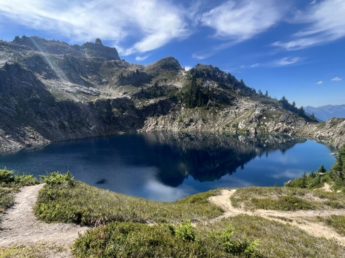
The pattern described above actually turned out to be necessary in order to make any miles. I had been looking forward to seeing the Goat Rocks wilderness since before getting on trail. I had seen pictures and videos in accounts by some previous hikers but had no idea of the magnitude of what I would experience. In actuality, you could probably get through the entire section in a day, maybe even with time to spare. But with the scenery as breathtaking as it was, I felt compelled to amble slowly, take in as much as possible and take a LOT of pictures! My plan from the start was to camp near the top of Old Snowy. I had heard that there were a couple sites that were really cool and hoped that I would be lucky enough to score one. I arrived at the junction to the alternate in the late afternoon. There was a nice campsite right there, but I also knew there were a couple higher up. I had to try. Looking at the climb, I was a bit intimidated as it looked super steep. I balked for a moment wondering if it was worth it. Did I really need to be that guy who gets in over his head and needs help getting out of it? Then I thought about San Jacinto, Baden Powell, Mt. Whitney. All missed summits because I didn’t want to get in over my head. This was my last chance at a summit and I had to go for it. I began working my way up and was surprised by how relatively easy the climb was. Of course one needed to be prudent in a few areas, but overall it was no problem and I found myself at the top in short order. Completely alone. I had the mountain to myself. As promised, there were a couple nice sites about twenty meters from the top. But there was also a site fit only for cowboy camping just a few feet from the summit. While the other sites were nicer in terms of comfort, when one has the opportunity to camp on a mountain summit, one camps on the mountain summit! And again, the rewards were infinitely greater than any discomfort. I had a 360 degree view of the entire area, and as the sun set it was illuminated in a soft glow with a splendid view of Mt. Rainier as it’s centerpiece. One of my favorite things to do both at home and on trail is to take my first cup of coffee and enjoy whatever view I have before me. If I can watch a sunrise, all the better. The sunrise view that I had the following morning, coupled with the scenery that I was surrounded by was enough to bring me to tears. This was it. The trail had already given me so much…I knew in those moments that whatever happened in the coming days and weeks, my journey was fulfilled. I could go home content with my experience. And moving forward, I could draw upon this moment whenever needed. Tough day at work? Car needs repair? Schedule feeling hectic? Whatever – I got to spend a morning watching the sun rise in arguably one of the most beautiful places in the country! Nothing can ever take that away from me. I was at peace.


But I did have to keep moving! I packed up my gear and began making my way down to the section known as the knife’s edge. When viewing it from a distance, it’s difficult to discern where the trail is and as such difficult to imagine how we would actually walk along it. But like everything that came before, as you continue to move forward, the trail reveals itself to you and the walking is relatively smooth. But it took forever! The three-ish miles from the summit of Old Snowy to the point where I entered the woods took hours. I stopped twice for long breaks. Even more for pictures and even more to simply marvel at where I was. Right now, the miles didn’t matter. I was reveling in the fact that I was fortunate enough to be here and I was soaking it all in. Finally though the trail descended enough to be back in the woods and I began to put in the miles. But now they came easy. I was in such a great mood that the miles just flew by. I stopped for a lunch break after a long climb to a view of Mt. Rainier and finally finished up the day getting into Whites Pass by late afternoon. There was a relatively large contingent of hikers there and everyone seemed to have a similar experience in the Goat Rocks: Being absolutely floored by the views and incredibly grateful to have been there.


Good feeling gone.
The next day we woke to rain. It’s bad enough camping in the rain as packing up a wet tent sucks. Hiking in the rain sucks too as you are now wet as well. But the area heading north out of Whites Pass is a popular equestrian area. And horses are not made to follow LNT rules the way hikers do. So the trail in this section is literally mud made of horse poop. And lots of it. It’s bad enough having to walk on it, but when it’s splattering all over your shoes, socks and anything else that is below knee high, it becomes quite disgusting – even for hiker trash. I’m honestly amazed that no-one got sick after that section – at least not that I heard of. Fortunately, the rain let up around noon so it wasn’t a complete soaker and there was even enough of a breeze to temporarily dry out my tent before setting it up (just so that it could rain again!). In all it rained three nights in a row. The biggest downer of this whole section wasn’t necessarily the rain but the fact that we were in Rainer National Park and the crown jewel was completely socked in. Ahh well, the introvert in me knows that everyone likes to be left alone now and again, I guess Mt. Rainier is no different! I continued on, looking forward to meeting my cousin (same one as the rafting trip; check out Trail Update number Six) at Snoqualmie Pass for a couple zero days which would be my last days off before the end of the trail.


Push to the end!!
After a couple days off taking care of chores, visiting family and relaxing, it was time to get back on the trail. From here on out it would be the push to the end. I was sore. I was tired. But I was also very motivated! After all, it was just a few hundred miles to the border from here. It still sounds absurd to say something like that, but after hiking nearly two thousand miles (another absurdity!) the fact that we were down to just a few hundred made it sound so easy! But, like anything in life that’s worthwhile, easy isn’t really part of the equation. Also, another word had entered our vocabulary: fire! Up until this point, we had been super lucky. Because it was such a high snow year and a wet spring, fire season had been delayed. But unfortunately it wasn’t a matter of ‘if’ but ‘when’ and the time was now. A friend of my cousin is a wildland firefighter. He keeps a close eye on these things as he knows that he could get called up at any moment. At the time I left, there were two fires burning further north, but at that time it didn’t look like they would impede travel on the trail. Hopefully.

The walk from Snoqualmie to Stevens Pass was one of the toughest sections of trail. But as previously mentioned, the effort was worth the reward. Beautiful rock formations towered over high alpine lakes. The views across the valleys seemed endless and though we were now into August, there were still plenty of wildflowers to add splashes of color to the landscape. Washington took a bit to get going, but wow was it worth the wait! Partway through the second day, I met a backcountry ranger. They asked how my hike was going, to which I replied, “fantastic!” I also mentioned that I was hoping to dial back my pace a touch in order to really take everything in for the last part of the trail. They said that I might want to keep pushing as we were into fire season and that it was super dry and wouldn’t take much for things to really change. Those words would continue to echo in my mind for the rest of the trip! We continued on to Stevens Pass where my cousin had arranged for a friend of his to pick us up and bring us to their home in Leavenworth. Not only did we get a chance to shower and do laundry, but we were also able to run errands and were treated to a home cooked meal besides. Once again, I was the beneficiary of the kindness of strangers, a constant theme for the entire trail.
Fire!
The stretch from Stevens to the small town of Stehekin is one of the longer ones in Washington. I had planned for six days but really hoped to do it in five. On the third day out, a large smoke plume was visible not far from the trail. A third fire was now burning, though this one was located such that it wasn’t affecting the trail and we were far enough north that we would be running from it rather than heading towards it. But this was the first visible sign of fire that we had seen and it was quite sobering to be this close. The ranger was right. Keep the pace high and hope to get to the end soon!
But the next day, things came crashing down. I had been on trail for about two hours that day when I came upon a friend and a couple other hikers at a junction. She said “I’m so glad I ran into you!” Which I found a bit odd. She went on to say, “Did you hear about the fire closure?” “What?!” I said in disbelief. Then one of the other hikers spoke up. Apparently their brother was keeping tabs on the fire situation and had just messaged them that the PCTA had posted news about a recent closure on the website. I was in shock. I set my pack down unsure of how to respond. I was half angry and half in tears. To come so far, only to be shut down this close to the end. I couldn’t believe it. My friend also had information regarding how to exit the trail and where to go from there. I took a picture of the map as it would now be my guide rather than gps. I put on my pack and continued to hike, trying to process what I had just heard. After a while, I decided that I needed to get the information myself. Not that I don’t trust others, but sometimes there can be exaggerations and I just wanted to be sure. So I messaged my wife at home and asked her to check the PCTA website for any information on recent fire closures and hiked on. It was really strange. For some time now, I had been in a lot of pain. There were many times where I wished that I could just stop and go home, but something made me keep going. Now that I was potentially looking at truly ending my hike, I didn’t like it at all. I did want it to end, but not like this. Damn.
A few hours later, I was stopped at one of Washington’s incredible vistas for a lunch break. By this point I had decided that if it were true and the trail was closed, that I would be ok with the hike ending. It had been an amazing journey and I really didn’t need the photo op. at the border. Or did I…? While I was eating, another couple who I had gotten to be friends with came along. I asked if they had heard the news and they said no. I told them what I heard and also told them that I was waiting for a response from my wife to confirm or refute what I had heard. Just then my device beeped. And again. And again. It was my wife who had read verbatim from the website regarding the fires. Apparently, one of the fires that I had heard about while I was in Snoqualmie had reached a point where the Forest Service decided that it would be prudent to close the trail in a couple of sections. One of those sections began just over a days walk from where we were currently standing. We had no choice but to follow the closure and get off the trail. Was this really the end…?

Boats ‘n cars ‘n…just get there!!!!
Leaving that lunch place, the mood was somber to say the least. We were so damn close. The first closure was almost exactly one-hundred miles from the border. I remember getting to the one-hundred mile mark in the desert. At that time, it felt like we had walked forever. But now, it was nothing. We were practically there!!! But it really didn’t make sense to make any decisions without getting more information as we still had almost two days of walking (if you count the balance of that day plus the next plus the partial day taking the closure). When we got to the actual closure in a couple days, we took photos as if it was our terminus. After all, if it was to be our last day on trail, we might as well have a record of it! The closure took us into Holden Village, an isolated little community that is almost completely self sufficient. It was a neat little place that is very welcoming and was a nice place to regroup. The downside is that they intentionally eschew internet and phone service as the goal of the community is to be able to truly disconnect from the hustle and bustle of the world; which is fantastic for those who make the choice to go there (kinda like going to summer camp!), but for a bunch of stranded hikers who have no idea what the immediate future holds, it can be frustrating to say the least. Those of us who were there decided that we would take the ferry to Stehekin where we could get more information regarding our options and then make decisions from there.


The next day after breakfast, we piled into the bus that would take us to the ferry to Stehekin. The mood was still pretty low as none of us really knew what or where. Could we still get to the border? If so how? Was it worth it? There was an alternate trail out of Holden but even the description said that it was difficult to navigate as it is not well maintained. Once in Stehekin we did what needed to be done: go to the bakery!!!! After all, one must have priorities! After gorging ourselves on sugary goodness, we set about the business of figuring out an endgame. As best as we could tell, the first closure was about twenty miles of trail. Then, there was a fourteen mile stretch that was open, but it dead-ended at a second closure that was also about fourteen miles. So effectively, the closure was about fifty miles long, leaving a fifty mile stretch that was open from the border south. It could be done! The road to Harts Pass junctions with the trail about thirty miles south of the border (at this time, the highway that would have taken us to the bottom of the open section was still closed due to said fires). If we could get to Harts Pass, we could still hike to the northern terminus. At this point, I was willing to let that twenty mile chunk go. With fires still burning and the air thick with smoke, it didn’t seem worth it to spend two days doing an out and back. We just needed to get to Harts Pass. Fortunately, one of my friends was able to secure a ride directly there from the town of Chelan. So all we had to do was take the ferry from Stehekin to Chelan and our ride would take us to Harts Pass the following day. If things went well, we could actually be at the border in three days! It was coming together, we just needed to make it happen!
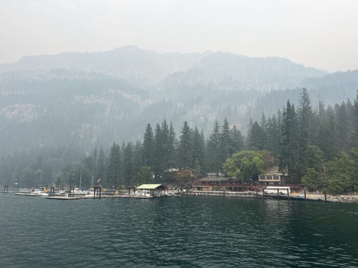
The next day, we began to put the plan in motion. We picked up our resupply boxes and promptly put half of the contents in the hiker box. Since our timeline was shorter, we didn’t need to carry as much. There happened to be a family of four in our vicinity that was prepping for a backpacking trip of a few days. Once I had everything in my pack ready, I simply brought the rest to them. There were a lot of snacks and the teenagers were more than happy to make them disappear! We boarded the ferry around two in the afternoon. It was about a four hour ride to the other end of the lake, and we were looking forward to a nice relaxing ride. The only downside was that the air was so thick with smoke that it was difficult to see much of the scenery. We got to Chelan in the early evening. Rather than eat out, we decided to grab some food at the grocery store. We found a cheap place to camp and simply had a picnic there – hiker trash style.

The following morning after breakfast, we decided to go back to the store to grab some items for celebrating at the border. On the way, we were stopped by a woman who asked if we were PCT hikers. When we told her we were, her eyes lit up. She told us that she had been dreaming of hiking the trail for a long time but wasn’t sure if she would ever have the chance. We told her that she should just make plans and do it and that it would be worth it. I really hope that she does! Then in the store, a couple gentlemen asked us about our hike, specifically how much we had left to go. We told them that we planned to get to the border the following day. This was met with a hearty congratulations and well wishes. It was as if we were celebrities – people randomly stopping us and asking about what we were doing and being genuinely interested and excited about our journey.

The drive from Chelan to Harts Pass was about three hours. It was mostly uneventful until the very end. We pulled up to the trailhead and our driver immediately got out, went to the back of the vehicle and shouted an expletive. One of the rear tires was completely flat! Had that happened earlier, it certainly could have changed our plans for the day! We offered to help him change it, but he insisted that he was fine and that we should get on our way. And with that, we began to make our way down the final stretch of trail. The air was thick with a mix of smoke from the wildfires and also with clouds that were threatening rain. Our hope was to get at least fifteen miles in so that we could get to the border the next day and still have time to hike back a ways in order to get back to the trailhead by the end of the third day. Spirits were super high and once again, the miles seemed to fly by. We were on our way to Canada and nothing – not even the rumbles of thunder around us were going to stop us now!

We got to our campsite just as it was getting dark. We had about thirteen miles to go to the border. We were practically there. After all of the planning, changing plans, hiking, wondering, waiting, this was it. Tomorrow, we would wake and hike like normal, but this time we would actually reach the destination that we had talked about for so long. For months, whenever anyone (not on trail) would ask us where we started, we would answer “Mexico”. This was almost always met with a look of disbelief. Then they would ask where we were headed, and of course we would answer “Canada” – which was usually met with another exclamation of amazement. But for much of that time, even to us it was an abstract idea. The miles were just to many to truly comprehend. But slowly, as the distance grew shorter, we began to see it as a reality. And now here we were, this abstract idea was about to become fully realized!
Full Circle

I woke the next morning at my usual time. I had my coffee and pretty much went through my normal routine of eating and packing up my gear. Thankfully, the rain that had been threatening the night before hadn’t happened so I didn’t have to pack up a wet tent. I was super excited to be heading to the border, but I also knew that I had two days of hiking and at least one more night of camping. No need to trip at the finish line! So I was careful to do everything just as I normally would. The mountains that morning were completely socked in with visibility sometimes just in the tens of feet. Every now and again it would spit just a bit of rain, but for now it was holding off. The trail through this area is spectacular. The views are wide open (except for the clouds!) and the trail tread is smooth and well cut and made for great walking – until the last five miles. It’s almost as if Washington wanted to make sure that I knew who was the boss and that I was just a visitor here. The rain began, so I donned my rain jacket. But it didn’t matter because the trail was overgrown and the wet branches made sure my lower half was completely soaked – right into my shoes. To make matters worse, the formerly smooth trail was blown out in many areas which made footing difficult. Washington was coming full circle: for all of the beauty we experienced there was also a lot of difficulty, and we were getting a taste of all of it right up to the end.

Normally I check my gps every so often to keep track of mileage, distance to water sources, etc. But I didn’t bother with it that day as there was plenty of water and I for sure knew where we were going. So I really didn’t know how far we had to hike until I heard voices – and laughter and shouts of joy echoing through the forest. We were close! And in a few minutes, there it was. In a small clearing, on a flat area between two slopes and between two countries, stood a small collection of wooden pillars. The official monument marking the end of the trail. Time seemed to suddenly stand still. I too had come full circle. I began the trail at the southern terminus on March 23rd on a cold rainy day. Here I was at the northern terminus, again on a cold rainy day, the date August 23rd – exactly five months later. So much had happened in those five months: so many miles, blisters, aches, pains, bears, sunsets, mountains, crazy hitches, incredible kindness, thousands of blowdowns, deep snow, freezing cold, intense heat, hunger, thirst, bars eaten, cat-holes dug, rivers crossed, views admired, deep friendships made, passersby…it all came rushing at me in an instant flashback. And just like how I began the trail, as my hand touched the monument, I broke down. I had made it. This incredible journey, this lifetime dream, it was now complete. I cried because it was over and I cried because it was over. As hard as a thru-hike is, there is a part of me that wishes that it would never end. Life isn’t easy on the trail, but it is simple. And therein lies the beauty. It allows you to see little things, like sunlight filtering through the forest, or a bee landing on a flower. It helps you appreciate small acts of kindness like a half a bottle of lemonade handed to you from a truck or a cookie given by a friend. It allows you to connect with amazing people that you might not otherwise meet and see sights you can only reach on foot. But most of all, you have time. Time to linger by a stream or a mountain view. Time to think. Time to ponder. Time to have a deep conversation without having to keep a schedule. Time to just be.


We stayed at the border for a couple hours, toasting our success, eating and for some of us, enjoying what might be the last time we would see each other. The group I happened to be with at the terminus represented four different countries. And while we exchanged contact information, it’s difficult to know if or when we might gather again. Finally, it was time to go. Four of us headed north into Canada while myself and another friend turned back towards where we had come from, and for the first time in five months, began hiking south. Now it was just a backpacking trip. Tomorrow we would reach the trailhead and from there would begin the “reintegration process”. We camped about ten miles from the border that evening. We were physically and emotionally tired, but we were also happy. We had achieved our goal and now we just needed to get ourselves back to civilization. Twenty miles? No problem!
The next day we woke to mostly clear skies. The overnight breeze had blown the clouds away and also served to clear much of the smoke. Blue skies were all around and we were treated to views of the terrain that was previously shrouded in haze. It was as if to say, “Well done, you deserve this.” Again, the miles came easy. Our packs were light and once again, the pull of town food was strong. But as we got closer to the trailhead, I had a sudden desire to slow down. It occurred to me that I was taking my final steps on the PCT. This place served as my home for the past five months. But not just that, it also served as my identity. I was a PCT hiker. People recognized it, I shared that identity with others and we’re damn proud of it. And now that was about to go away. Without the trail under my feet, without my pack as a constant companion, was I still a PCT hiker? And thus began the most difficult part of the journey: letting go. From this point forward, I would have to rely on my memories (and over two-thousand pictures!) to keep me connected to the trail. But I also knew that I was a different person than I was at the beginning. It’s hard to put a finger on, and even more difficult to put into words, but I could feel it. And as such, knew that I would always be able to draw on this experience whenever needed. “Yes. Yes I am. I am a PCT hiker!”

We finished out the last mile of trail. And I don’t know how, but there was one more piece of trail magic waiting for us. For at the exact moment that we reached the trailhead, a pickup truck pulled up. A few other hikers had hailed it and the driver said, “It’s a one-ton truck. You can fit as many people as you want in there.” And without even stopping, we took off our packs, climbed in and began heading home.
See you on the trail.


This website contains affiliate links, which means The Trek may receive a percentage of any product or service you purchase using the links in the articles or advertisements. The buyer pays the same price as they would otherwise, and your purchase helps to support The Trek's ongoing goal to serve you quality backpacking advice and information. Thanks for your support!
To learn more, please visit the About This Site page.

Comments 2
Congrats on finishing the PCT.
Congrats, your completion of this, the biggest challenge that you’ll have in your life is finished. All the rest is like you surmised. You will draw on this one. I am a Sierra hiker of yester-year. I’m now 76yrs old and have spent many weeks in the areas that you past thru, always wishing to do what you did. But I must say I’ve got one on you, I have used Whitney as a life training lesson for my daughter at age 15. I first had the lesson at age 17 at the first Easter service on the top in 1964, I think? Back again in 1995 because my wife wanted to see what all the fuss was about.
You remember all your reflections on that last day because that is all we have is our memories and you used all the right words and had all the correct emotions.
Have a good life!
Ken