 ">
">
And So it Begins
The Challenge is Quickly Approaching
I am just a few days away from the first section of the Hiker Challenge! Over the years, the Challenge has alternated the starting point, one year starting at the Northern Terminus and the next starting at the Southern Terminus. Last year was unique; the Challenge started around the halfway point, heading north to the Northern Terminus, and once reaching that, switching back to the halfway point and heading south. There was an issue with shuttles last year which caused this new schedule. This year the schedule is back to normal, going southbound. I personally think that this direction is the best way to hike the Trace. The first quarter of the trail heading southbound is a little easier and better for building your hiking legs. For those in the Challenge, going southbound is the perfect introduction as the first few sections are comparatively easy to hike and help to get you in the flow of the Challenge. An added bonus – by going south, the Challenge will reach the Big South Fork in Tennessee in the fall, which is one of the best times of the year to be there.
Support
One great thing about the Sheltowee Trace is that the Association is active in the development of the sections of the trail and has plans to expand it! They have been trying to expand it south for a few years, and it would appear that this year they will succeed in doing just that. The Association has released the sections of the Hiker Challenge, and they line up so that we will finish at the new Southern Terminus – the Rugby Visitor Center in Rugby, TN. This means that instead of 343 miles, the Trace will now be 352 miles!

The STA is supportive of all hikers who want to participate in the Challenge. Before stepping out on the trail, all participants are required to attend an orientation session. During this session, a participant will learn all about the Challenge through the years, and what they need to know to succeed in the Challenge. As you can see in the picture below, the Challenge has a lot of participants each year, and close to 600 people have completed the Challenge in the past 12 years, earning the End-to-Ender title.
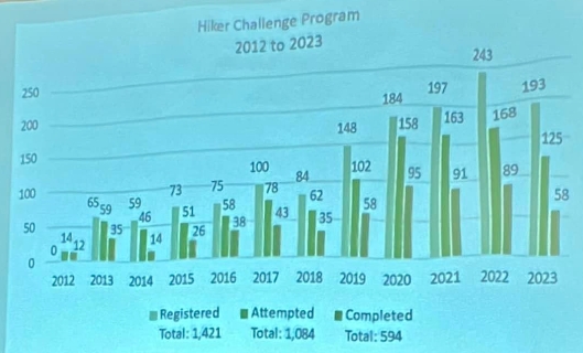
The Hiker Challenge stats, presented at orientation
A daunting part of the Challenge is the fact that each section is 25-35 miles. Hiking these miles over two days can be a little intimidating, especially if hikers have not backpacked more than 10-12 miles on any day before. But the Sheltowee Trace Association Director is supportive and breaks down the mileage simply – “If you can backpack at a 2 mile an hour pace, for 8 hours a day, you will have no problems completing this challenge”.
Weather
Over the last 12 years, the Hiker Challenge has only postponed a hike due to weather 2 times – record scratch. Make that 3 times now. The first section was supposed to be last weekend, but Kentucky received 4″-6″ of snow and the temperatures dipped into the single digits. Due to these conditions, the Sheltowee Trace Association decided to postpone the hike until this weekend. I think that this was the best decision for the safety of everyone involved. However, I was certainly disappointed as I was ready to start hiking and was looking forward to this extra weather challenge!
Looking ahead, the weather this upcoming weekend is going to be a different kind of challenging. It will rain most of this week and weekend, so I can expect the trail to be a muddy mess in some places. The good news is that the temperature will be in the 40’s, so I will not have to deal with freezing rain!

The author on his first solo backpacking trip in the snow in 2021.
How I Will Avoid Getting Lost
The Sheltowee Trace was added to FarOut in late 2022! Before the map became available, Challenge participants would receive 3–4-page electronic Trace Notes before each section. These PDF guides would cover the section in detail with information on where to meet for the shuttle and where to camp, and even included turn-by-turn directions! These notes combined with the paper maps helped participants succeed in navigating the Trace (a task that can be very difficult on some sections of the trail!).
For my navigating needs, I will use a combination of sources, including FarOut, paper maps as a backup, and the controversial AllTrails app. AllTrails has a bad reputation and is probably looked at with disdain by most hikers. The reputation is well earned if you expect AllTrails to be the perfect companion and extremely reliable. But, if you accept its failings and use it as only one tool in your belt, then it can be very useful. I have used AllTrails on every one of my hikes over the last 3 years and I have always been a big fan of it. When I participated in the Challenge in 2022, I used AllTrails to help me navigate around by creating my own map online using a combination of what AllTrails showed and the Trace Notes. I then downloaded and saved that map to my phone to use for navigation.
One of the main reasons I like AllTrails is the recording feature. I have recorded all of my hikes with AllTrails and I love to create trip reports following each adventure, referring back to the recordings for stats. I have used other apps to record, but they always seem to have issues recording and AllTrails is the only app that I have been able to reliably trust. I will often use these other apps for additional guidance, as I have found that GaiaGPS can be a little more detailed with some trails, or have smaller side trails listed where AllTrails would not. Now that the entire Sheltowee Trace is on FarOut, I will try out its recording feature for the first section. I have backpacked this first section before and I don’t expect any new surprises, so this would be the perfect opportunity to test out a new recording app. I like that it has a create route feature as well, so I don’t have to spend time in AllTrails creating a unique map. Instead, I can just drop some pins on the already-defined map to create the start and end of the section.
I will report back on how this recording goes next week when I post a trip report covering this first section. I am beyond excited to start on the first leg of my adventures for this year!

This website contains affiliate links, which means The Trek may receive a percentage of any product or service you purchase using the links in the articles or advertisements. The buyer pays the same price as they would otherwise, and your purchase helps to support The Trek's ongoing goal to serve you quality backpacking advice and information. Thanks for your support!
To learn more, please visit the About This Site page.
