 ">
">
Juan Day at a Time
The rain stopped not long before I got up, and it held off for most of the day. Wet, overgrown trail meant wet feet for the first few hours. There was a dusting of snow on San Luis Peak, and a cold breeze that capped temperatures at the lower threshold of comfortable. I removed my jacket and gloves for each climb, but had to keep them on for everything else. All things considered, I had no complaints.
At midday, beneath a layer of dynamic, densely-packed cumulus clouds, I reached the junction for the Creede cutoff. Decision time.
- Take the cutoff. It would shorten my itinerary by three days, bypass much of the San Juans, and possibly avoid some of the bad weather in the forecast.
- Stay on the CDT. Five days of cold, wet weather were predicted, and this was day one. I’d be in Lake City tomorrow, and I could extend my stay if conditions worsened.
I’d read and heard so many good things about the San Juan Mountains. People I’d met couldn’t recommend them highly enough. In fact, I’d begun to wonder if the San Juans would be able to live up to the hype. Now, I was more concerned that low cloud might hide them completely. All I could do was stay on the redline and hope for the best.
Day one: Snow Mesa
It quickly became apparent that alpine tundra is the defining feature of the San Juans. There were no trees blocking the view, and if anything, people had understated the stark beauty of the landscape. Shifting cloud formations created spotlights and shadows, and the overall effect was slightly hypnotic. In every direction, there was an extraordinary amount of detail to absorb. (Now I’m in danger of over-hyping the place.)
Late that afternoon, the trail ascended the north side of the Continental Divide, switchbacked across a broad ridgeline to begin its descent, and gradually revealed the scene to the south. It’s difficult to describe without using the word awesome, but it is possible to summarize what I saw and how I felt: disbelief. It didn’t quite seem real; like seeing the Grand Canyon for the first time or witnessing a solar eclipse. I stopped for a few minutes to take in as much as I could, then descended to Snow Mesa and started looking for somewhere to camp.
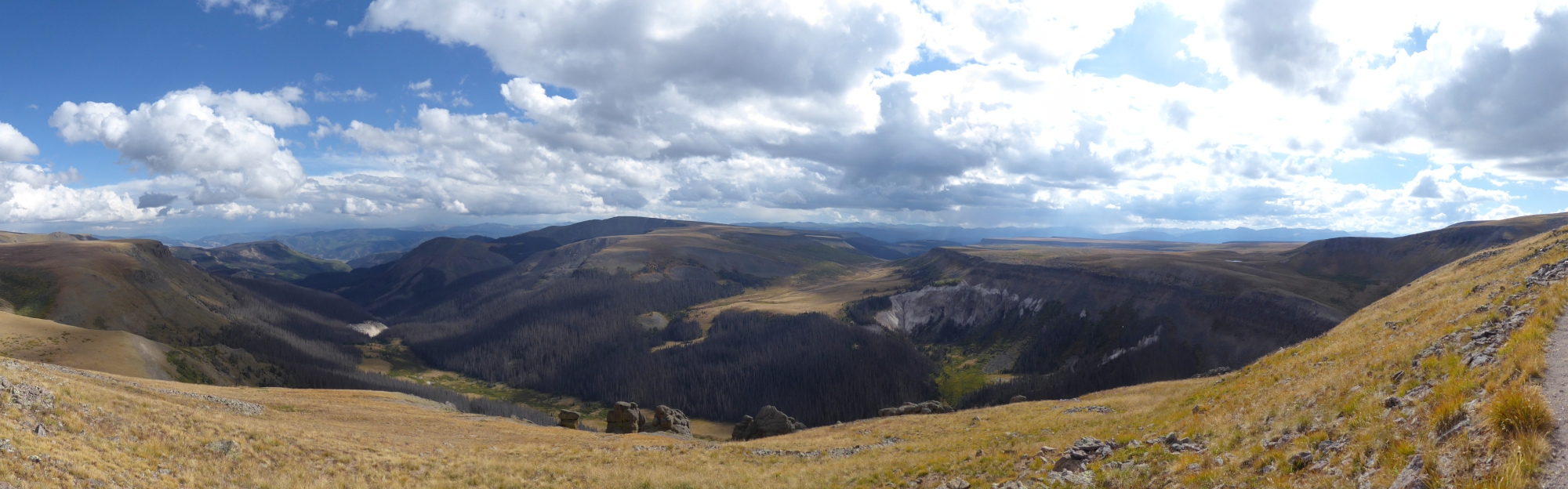
Table Mountain (center) and Snow Mesa (right).
Of my ten CDT campsites above 11,500 feet, six were in the San Juans. That night’s campsite, at an elevation of 12,308 feet, takes second place on the list. Camping in Colorado, and particularly in the San Juans, meant spending the night in areas with nowhere to hide from the wind. It wasn’t the first night I felt vulnerable, and it wouldn’t be the last. Fortunately, although the mesa was flat and exposed, there was only a light breeze, and I slept well.
Day two: Lake City
It was less than five miles to Highway 149, so I slept in until 6:30 a.m. Despite the insulating layer of thick, featureless cloud just a few hundred feet above my head, the air was surprisingly cold. I hurried west as the layer slowly descended to ground level. At the edge of the mesa, I dropped out of the mist and arrived at Spring Creek Pass just before nine. The road was quiet, and I resigned myself to a long wait.
An SUV pulled into the parking lot ten minutes later, and the driver, Irina, offered me a lift into town. Her husband and his friend were hiking the remainder of the Colorado Trail (CT) SOBO, and we waited while they unloaded and organized their gear. Next, we made a pitstop at Irina’s vacation rental, where she introduced me to her sons, Alex and Dimitri. She then offered me an array of food, and it was only with a supreme effort that I avoided behaving like Cookie Monster. Irina and her family were incredibly hospitable, and I can’t thank them enough.
Alex had thru-hiked the PCT, and we compared experiences while he drove me the rest of the way to Lake City. I ate lunch at Southern Vittles and walked almost a mile across town to resupply at the Country Store. I’d completed about half of the return journey when a thunderstorm arrived. By the time I checked in at the Bushwhack Lodge, I was soaked. The heavy rain gave way to steady drizzle which lasted until the evening, and I was glad to be indoors.
Day three: High Point
Hitching out of Lake City was a bigger challenge than getting there. After waiting at the southern end of town for an hour, I started to wonder if everyone drove side-by-side ATV’s or vehicles with Texas plates. A big thank-you to Mrs. Susie Arnold, of the local Presbyterian church, who drove up to the trailhead just to drop me off.
Once again it was my lucky day, weather-wise. There were a few patches of blue sky, an interesting cloudscape, and a handful of small storms that weren’t close enough to be a concern.
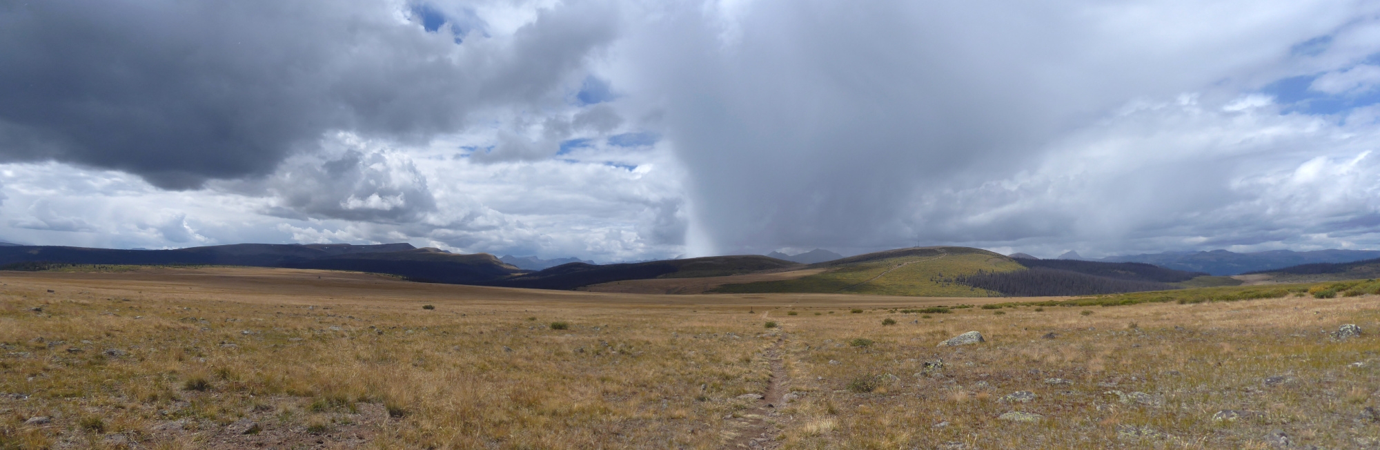
A mid-September afternoon in the San Juans.
My only opportunity to get water that afternoon came less than ten miles from the trailhead. There, I met a SOBO CT hiker named “Roadrunner” and a bull moose who didn’t have a name. Or maybe he did, but I didn’t ask. What the moose definitely did have was a stubborn streak. It was snacking on the dense willow bushes surrounding the stream, and refused to move so that Roadrunner and I could fill up. At a safe distance, under the moose’s wary eye, we bushwhacked to the water source and collected enough for camping.
A few miles later, and about 1000 feet higher, it was only a matter of time until we were engulfed by cloud. The pictures we took of each other at the CT High Point (13,271 feet) had a featureless, gloomy backdrop. Not long afterwards, we descended from the mist and spotted an old mining claim where we decided to make camp. And not a moment too soon. We settled in for a cold night just as snow began to fall.
Day four: The Cabin
Next morning, there was a layer of frozen condensation on the inside of my rainfly, a thicker layer of ice on the outside, and a dusting of snow on top of that. Detaching the fly was a real struggle due to ice inside its clips. I left camp slightly later than usual but was still on trail before Roadrunner emerged from his tent.
Overnight, a thin layer of snow had been deposited at higher elevations, including my first mountain pass of the day. The sky remained clear for the first three hours, as cloud filled the southern horizon and made its slow, steady advance. At midday, a small, fast-moving thunderstorm swept across the trail from southwest to northeast. I was close enough to hear the thunder and receive a shower of tiny snowflakes, but not too close for comfort.
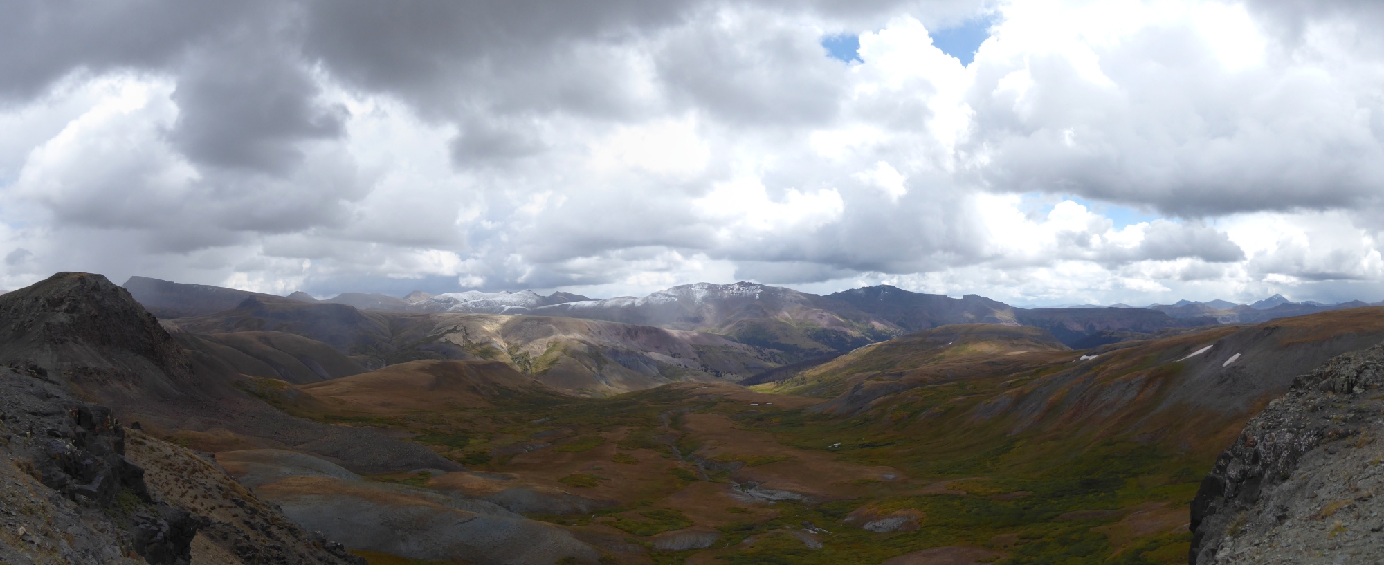
More afternoon storms.
At Stony Pass, I met another CT hiker, Ian, and hiked with him as conditions continued to deteriorate. Our conversation was cut short by two new arrivals. The first was Roadrunner, jogging in order to stay warm. A few minutes later, an unwelcome guest: a snow squall. A biting northerly wind blasted us with small, stinging flakes, and Roadrunner resumed his jog. Very soon, I also had to speed up to keep warm.
During our brief three-way discussion, we agreed to meet at an old miner’s cabin just south of where the CT and CDT diverge. The snow had stopped and the wind had dropped by the time we were all safely there. More storms came and went during the night, but the roof didn’t leak, and all three of us enjoyed our warm, cozy accommodation. Four of us, if you count the rowdy, brazen mouse who lives there.
Day five: Low Point
There was an inch of snow next morning, which didn’t come as a huge surprise. We were at 12,100 feet, and the weather had been getting progressively worse for four days. Ian and Roadrunner headed for Silverton, while I hiked deeper into a wilderness that had recently been repainted in monochrome. There was a heavily overcast sky, but no precipitation. Yet.
I dropped below the snowline around 11,500 feet, started the subsequent climb, and soon stopped to remove my jacket and gloves. Ten minutes later, I put them back on. I’d been hiking for less than 90 minutes, and although I didn’t know it at the time, it was the warmest I’d be all day.
The trail that morning was overgrown, even by CDT standards. Waist-high, shoulder-high, and taller-than-me willow bushes. All of them heavily loaded with almost an inch of freezing-cold, wet, slushy, heavy snow. It wasn’t raining, but that didn’t matter because I was completely inundated. Everything overhanging the trail dumped everything it held on the first unfortunate passerby: me.
Personally, I like to reserve my swearwords for special occasions: pain, frustration, emphasis. That morning was especially frustrating, and I did a sh*tload of swearing. I swore loudly, repeatedly, and creatively. I made nouns out of verbs and verbs out of nouns. There were profanities old and new, traditional and novel, established and improvised. I briefly turned the gray skies blue.

Leaving the cabin.
Apologies
To: NOBO hikers “Sand Pig” and “Sloth”.
I’m not proud of my behavior. I know I said, “Sometimes I forget I’m not out here alone,” but that’s no excuse.
I’d also like to say sorry to the moose browsing the southern shore of West Ute Lake. Finally, my apologies to the flock of birds who were sufficiently appalled that they headed south for the winter.
Fingers crossed
Soon enough, wet vegetation became a moot point. Overgrown trail wasn’t a concern once the showers started. At first they were intermittent, but they quickly became a drenching, heat-sapping, relentless rotation of rain, sleet, and snow. Several times, I considered stopping to camp, and each time dismissed the idea. My feet were cold and my hands were numb, but I really didn’t want to stretch my rations an extra day. Of course, if it had been marginally colder, wetter, or windier, I wouldn’t have had a choice.
During my final climb of the day, there was a break in the weather. Just after I crossed an unnamed pass on the Continental Divide, the cloud thinned, and I felt a hint of warmth from above. In the valley below, about 1,500 vertical feet and slightly more than three miles away, a broad sunbeam illuminated the meadow where I planned to camp. Like so many afternoons on the CDT, I wondered if I might dry out before getting there. And like so many afternoons, the answer was no.
The cloud thickened, the sunbeam’s aperture closed, and the rain resumed, heavier than ever. By the time I reached the valley floor, I was once again saturated. To collect drinking water, I waded into La Vaca Creek without removing my boots or gloves. It didn’t matter – I might actually have been drier afterwards.
I camped on the east side of the meadow, mopped my sopping tent floor, and changed into dry clothes before getting into my sleeping bag. As circulation and sensation returned to my extremities, I was able to cross my fingers and hope for better conditions tomorrow.
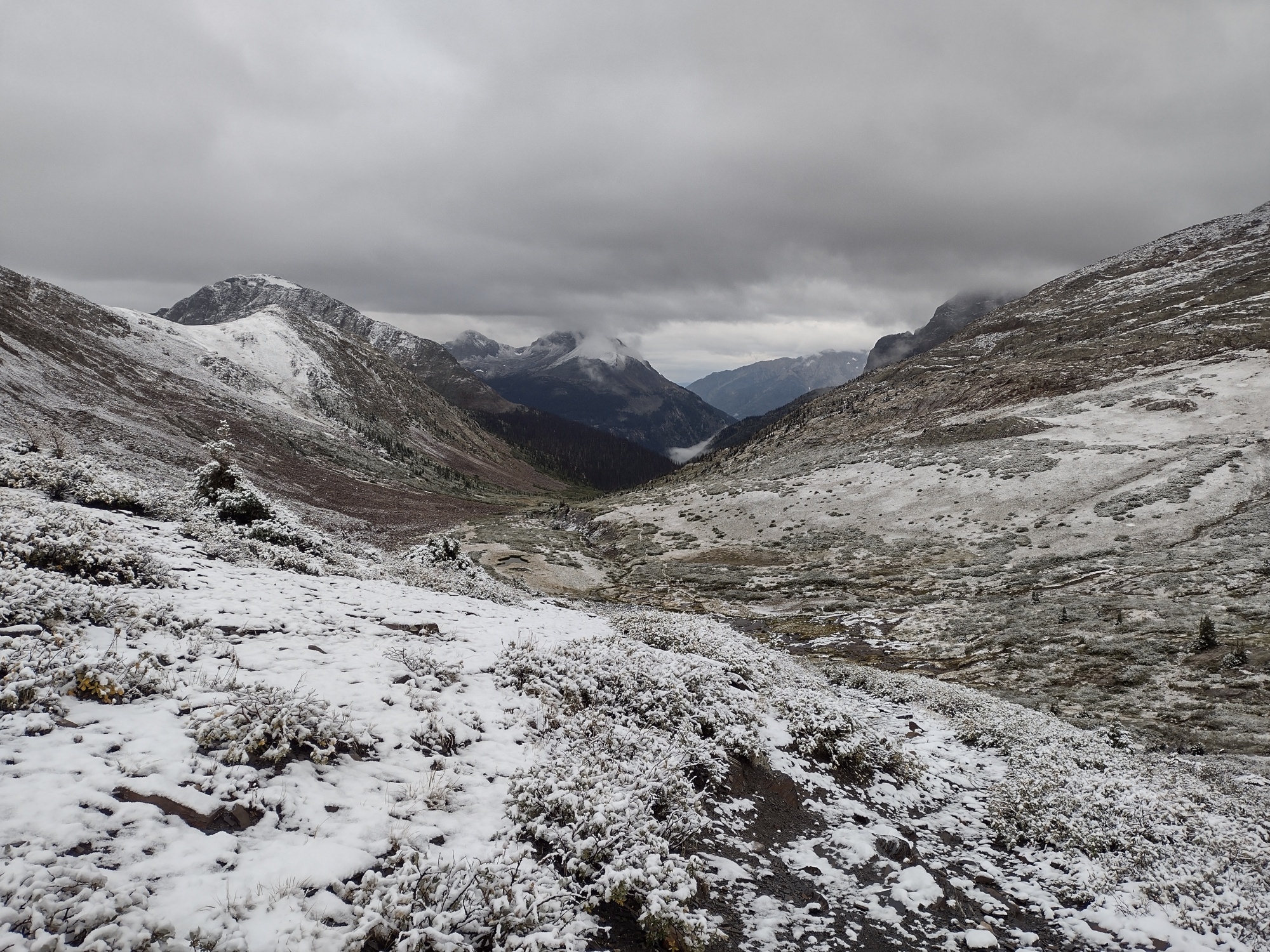
Hunchback Pass, morning of day five.

This website contains affiliate links, which means The Trek may receive a percentage of any product or service you purchase using the links in the articles or advertisements. The buyer pays the same price as they would otherwise, and your purchase helps to support The Trek's ongoing goal to serve you quality backpacking advice and information. Thanks for your support!
To learn more, please visit the About This Site page.

Comments 2
Richard,you write well and descriptively.Will be following your progress.
Ah, some Type 2 fun. Like a lot of “life”. But at least you were in an amazing area.
I whack at the bushes ahead of me to get’em to drop their load of snow, but that helps only so much…