 ">
">
Forester, Mt. Whitney, and KMS
Day 159
Around 6 am, Hobble-it shook my knee. We packed our gear and walked 20 minutes to Von’s, where we caught the bus from Bishop to Independence. I had to wait for the post office to open, but I told Hobble-it to go on ahead. At 9:30 am, I picked up my last resupply box. After stowing it in my pack, I walked a little ways up the road towards the mountains.
It took me 30 minutes to get a hitch from the second vehicle that went by. The occupants were a man and son going for a day hike. We chatted about east vs west coast hiking. Soon I was back on trail, hiking gradually towards Kearsarge Pass. For entertainment, I put on the final Heroes of Olympus book.
Near the top of the pass, I again admired Big Pothole Lake, which was mostly covered in ice. I was fascinated by the multiple shades of blue. Not far from the pass, I took the trail towards and around Bullfrog Lake, getting different views than from the higher route that I took into town. Once I rejoined the PCT, there was a brief sprinkle of rain.

Four miles along the PCT, I rendezvoused with Hobble-it at a tent site adjacent to Bubbs Creek. It had a bear box; useful as neither of us could fit all our food in our bear canisters. As I filtered water beside the peacefully burbling creek, I felt a tendril of sadness that within a week I will be off trail. Hobble-it was trying to warm up in her hammock, so I ate dinner beside it, chatting with her through the rain tarp.
Day 160
Per usual, I rose before dawn, dug a cat-hole, and fetched my food to eat breakfast. I felt refreshed from my best night of sleep in weeks! By the time I took down my tent, it had grown light enough to see without my headlamp. The ascent of Forester Pass was gradual. I soon passed Hobble-it and saw no one else, enjoying the discovery of the trail’s twisting route.
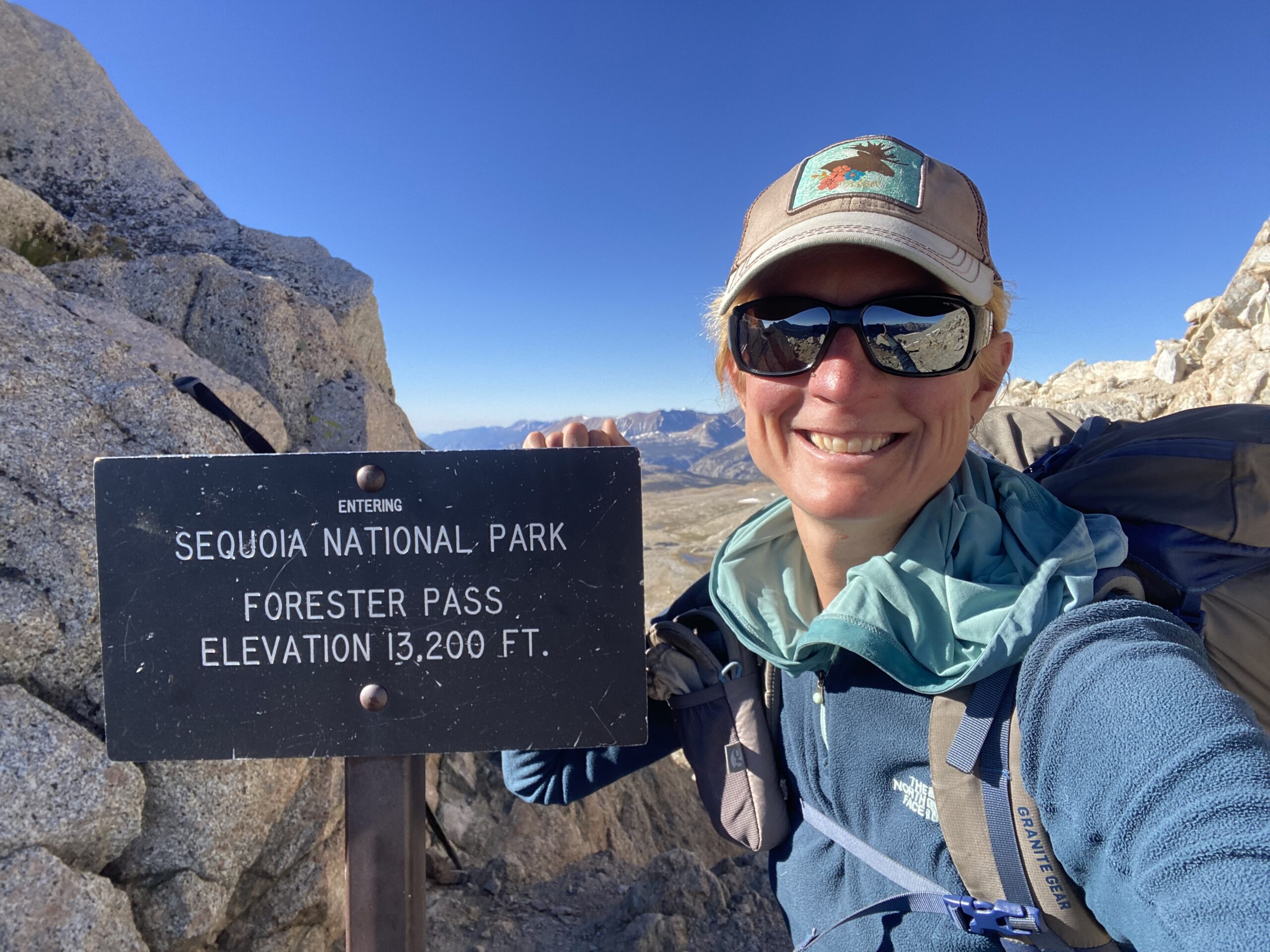
Forester was not particularly scenic, mostly rock with a couple barren lakes. Patches of snow-covered portions of the trail; I walked around most of them. At 13,200 feet, it was the highest pass on the trail. I preferred the south side, which had sweeping views and a well-built trail that hugged the steep slope. When I reached flatter terrain, occasional chubby marmots ran off at my approach.

Maybe four-ish miles from the pass, I took a snack break, joined by Hobble-it. She got nauseous and dizzy near the top and was still recovering. On the next ascent, I smelled smoke and saw a thick haze in the distance. I remembered that there was a fire in Sequoia National Park. The next 4-5 miles were fairly smoky, and I got a slight headache.
By the time we reached the PCT/ JMT junction, the air had cleared. Hobble-it and I camped near the Crabtree Meadow Ranger station and Whitney Creek. Again, there was a nearby bear box. We are going to climb Whitney tomorrow!
Day 161
When I woke before 1 am, I felt chilled. From nearby, I heard Hobble-it getting ready to hike Whitney. Somehow, I fell back asleep until ~3, but was still chilled so I decided to get up and hike. By 3:40 am I was on trail; my pack felt light with only the essentials needed for the day. The cold air kept me hiking at a good pace.
As I got closer to the peak, I saw the light of headlamps moving along its dark silhouette. By the time I reached a series of switchbacks, I no longer needed my lamp to see. The dawn revealed rocky spires and alpine lakes. At the portal, where the east Whitney trail met ours, a fierce breeze hit me. From there on up to the summit, it was very cold. Intermittently I hiked with my hands in my puffy pockets. My water froze to a slushy consistency.

At 8 am I reached the summit of Mt. Whitney, the highest peak in the lower 48 states. Hobble-it was getting her picture taken when I arrived (she’d been in the summit hut for an hour, warming up and recovering from nausea & dizziness). After she took my picture, we quickly got off that cold summit. Many miles later, we took a break by Guitar Lake to eat snacks and bask in the sun. Smoke from the Sequoia fire added a haze to the air.
Back at our campsite, we decided to stay for the rest of the day. Hobble-it napped while I did camp chores and organized gear. Then the two of us watched a couple Ahsoka episodes in my sun-warmed tent. We chatted with a couple friends, Mad Squatter & Helen Keller, who were on their way back from the summit. Afterwards, we ate an early dinner in the sunshine and got cozy in our respective shelters before darkness fell.
Day 162
Last night Hobble-it loaned me her torso-length foam sit pad. With more protection from the cold ground, I slept better than the previous night. It was good that we slept with our filters because Hobble-it’s water tube froze. My water was in my tent and stayed entirely liquid.

It was one mile from our tent site back to the PCT. Almost immediately the terrain changed to sand with rounded rocks of varying size and sparse trees. Mid-morning, I took a coffee and water filtering break. Around noon I crossed from Sequoia National Park into Inyo National Forest.

At Chicken Spring Lake’s outlet, I caught up to Hobble-it and stopped for lunch. The lake was above 11,000 ft. and the elevation made her somewhat nauseous. Cottonwood Pass came shortly after and then the trail dropped in elevation. I finished my book and was quite happy with the conclusion of the five novel, Heroes of Olympus series.
We ended our day at a sandy campsite after covering 24.6 miles on the PCT. I walked a short distance to get water from Diaz Creek. Then Hobble-it and I chatted from the doors of our shelters. After several days of wind, the lack of one seemed a little eerie.
Day 163
It was an overcast morning, though the clouds slowly dissipated rather than producing rain. I felt lethargic on the first climb, which had scenery similar to yesterday; lots of cool, lumpy rock piles. At the bottom of the subsequent descent was a creek, at which I caught up to Hobble-it. We snacked and filtered water.

I powered up the second climb, accidentally missing our planned lunch spot due to moving faster than expected. Hobble-it anticipated my oversight and found me at the top, where we had a leisurely lunch. We chatted and hiked together most of the afternoon. The sand and lumpy rocks disappeared, replaced with dirt and a mixture of brush.
Late in the afternoon, the trail descended into a valley. We crossed a giant, sturdy bridge over the Kern River. It seemed odd in what felt like high desert. There was a final climb of 500 ft. followed by a gradual, brushy descent. Hobble-it & I camped in a lovely wooded spot after a respectable 29 mile day.
Day 164
With only 11 miles until Kennedy Meadows South (KMS), I woke highly motivated. I was out of camp 15 minutes earlier than usual. The chill morning and mostly downhill grade made for fast hiking. After ~3 miles, I spotted a group of tents and saw PBS waving. I went down the side trail to say hello and chat briefly.

KMS itself was anti-climactic. I pictured the ultimate hiker hangout in an idyllic setting. It was a campground store with a large deck and a port-a-pottie. Still, I was excited for a real meal and the chef immediately offered a couple GF friendly options. I ordered a cheese & veggie omelette, then got chips from the store. An over balance of sweet snacks and lunches had me craving savory food.
We clapped as Helen Keller, Mad Squatter, and four others arrived and finished the PCT. Then PBS arrived and I initiated more clapping. I bought a flight to Montana, arranged travel details with Karin, and caught up with PBS. My two friends took off while I was taking care of a final online task. Afterwards, I got distracted talking to Helen Keller; he is a chef from Canada.
Back on trail, the terrain was fairly flat with a lot of scratchy brush… so happy that I hike in pants! At times, only a greater amount of footprints distinguished the PCT from an ad hoc route around a bush or other obstacle. After three hours, I came upon Hobble-it’s hiking poles pointing off trail. I found her and PBS settling into camp. The three of us ate dinner together and enjoyed a warm evening.

This website contains affiliate links, which means The Trek may receive a percentage of any product or service you purchase using the links in the articles or advertisements. The buyer pays the same price as they would otherwise, and your purchase helps to support The Trek's ongoing goal to serve you quality backpacking advice and information. Thanks for your support!
To learn more, please visit the About This Site page.
