 ">
">
PCT Shakedown Hike on The Shawangunk Ridge Trail
 From the day I got my PCT permit on January 19th, I started gear shopping for my trip. I wanted to get everything quickly so I would have time to test it out and get replacements if needed.
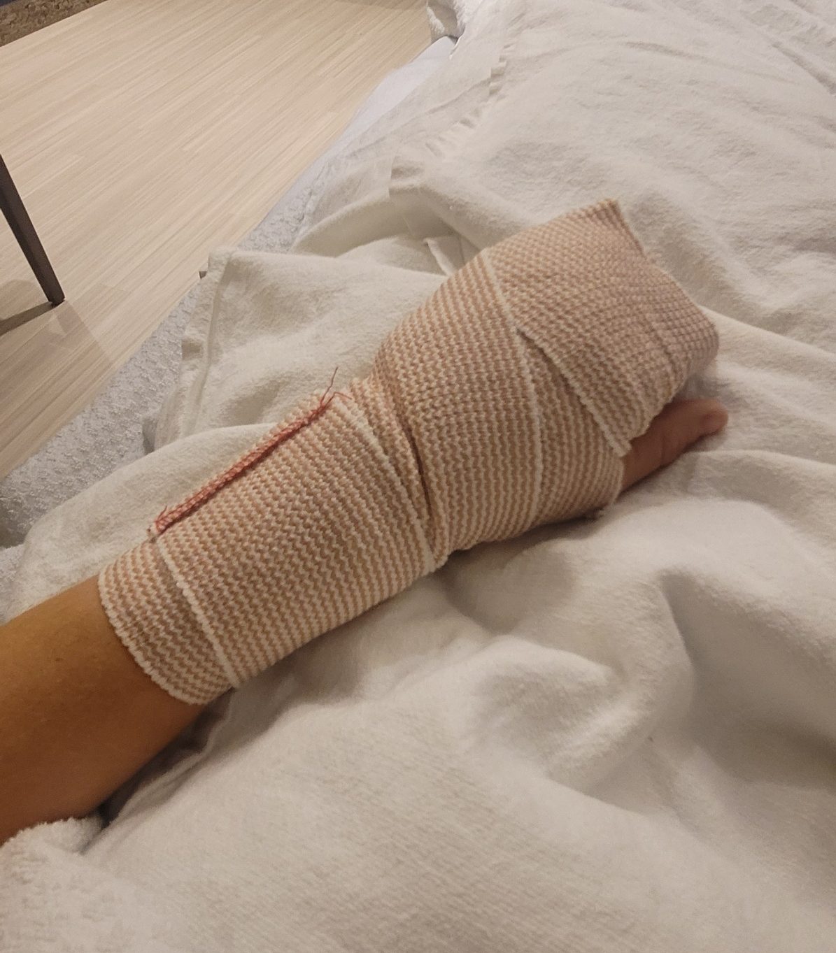
Once my gear was assembled I was ready for my shakedown hike. A shakedown hike is a shorter multi-day hiking trip to try out your thru hiking gear. And that’s when I got a horrendous infection in my hand. I wish I had some great story of how it happened, but truth be told it was a papercut from opening boxes full of hiker food I had ordered online. A papercut! This silly papercut landed me in hospital for 5 days on IV antibiotics and surgery to clean out the joint. My preparations would have to wait.
Sitting in the hospital I had plenty of time to pick out a shakedown hike. I wanted something long enough to test out my tent and sleeping system for a few nights, but it had to be local to where I live. I decided on a trail that happens to end in my hometown, the Shawangunk Ridge Trail. I have hiked many sections of it before unknowingly, so this was a great opportunity to hike it in full.
The Shawangunk Ridge Trail (SRT)
The Shawangunk Ridge Trail (SRT) is a 71-mile trail from New Jersey up to the beautiful Mohonk Preserve in New York, following the Shawangunk ridge made up of Shawangunk conglomerate, a rock specific to the region. Unfortunately, there is not much information online about the SRT. It seems to have been built and maintained bythe New York-New Jersey Trail Conference, but even their site is lacking information. There are also a few trail logs online and even an annual ultra-marathon along the trail, but each map is slightly different with different endpoints for the trail.
Another issue is where to camp along the trail. In the southern half, it’s pretty easy. High Point State Park has paid campsites if you want to camp the night before. Then you pass through many small state parks that allow backcountry / primitive camping. Backcountry camping means no pre-determined campsites, no amenities, no water, no campfires, no bathrooms; and you have to set up your tent at least 150 feet from a water body, road, or trail. The first of these parks is Huckleberry Ridge State Forest, then Gobblers Knob State Forest, and then Bashakill Wildlife Management area where no camping is allowed. Then the trail starts to ascend the ridge through Wurtsboro Ridge State Forest, Roosa Gap State Forest, and Shawangunk Ridge State Forest, all of which allow primitive camping.
After you cross highway 52 it gets tricky. The rest of the trail is through Minnewaska State Park and Mohonk Preserve, neither of which allows camping. The only place to camp is to get off the trail and go to nearby campsites or take a cab into a town. The first such area is Witch’s Hole State Forest, which is 5 miles down the High Point Road (a carriage road/trail) from Sam’s Point parking lot and trailhead. Further along, near the Mohonk Preserve Visitor Center, you can pay 38$ to camp at the Samuel F. Pryor III Shawangunk Gateway Campground, managed by the American Alpine Club. Other than that you can try to get a car to another nearby campsite or vacation rental, but there are no other campsites within walking distance to my knowledge.
Another to be aware of, which confused me, is where the trail ends. The trail officially ends at Mountain Rest Road, near the main entrance of Mohonk Mountain House. However, the Shawnkgunk Ridge Ultra Run and numerous recordings on sites like AllTrails and Strava have the trail continuing north through private land. If you go northeast from Mohonk Preserve you will pass through private land to the Giants Ledge Pocket Park, which connects you to the Wallkill Valley Rail Trail and the Rosendale Trestle. I do not suggest taking this route given that it crosses private land in spots. It’s best to end your hike at Mountain Rest Road. If you want to connect to the Wallkill Valley Rail Trail or the town of New Paltz, you can walk down the Mountain Rest Road (winding and no shoulder so not the best idea) or go over to the very pretty River to Ridge Trail.
The Hike
My goal for the beginning of the PCT is around 20 miles a day, so I figured I could cover the 71 miles of the SRT in 3 days and 2 nights. I started on April 2nd so the weather was chilly with highs in the upper 50s and lows of 20 degrees at night, perfect for testing out my cold weather gear.

Day 1
My family dropped me off at the trail’s start in High Point State Park, the highest point in the state of New Jersey. There is a monument in the park and a couple of viewing platforms, but there isn’t much to see. I started out just before noon, knowing I had 18+ miles to go. It was snowing out which was a little concerning, but I had my zero-degree quilt so I would be fine.
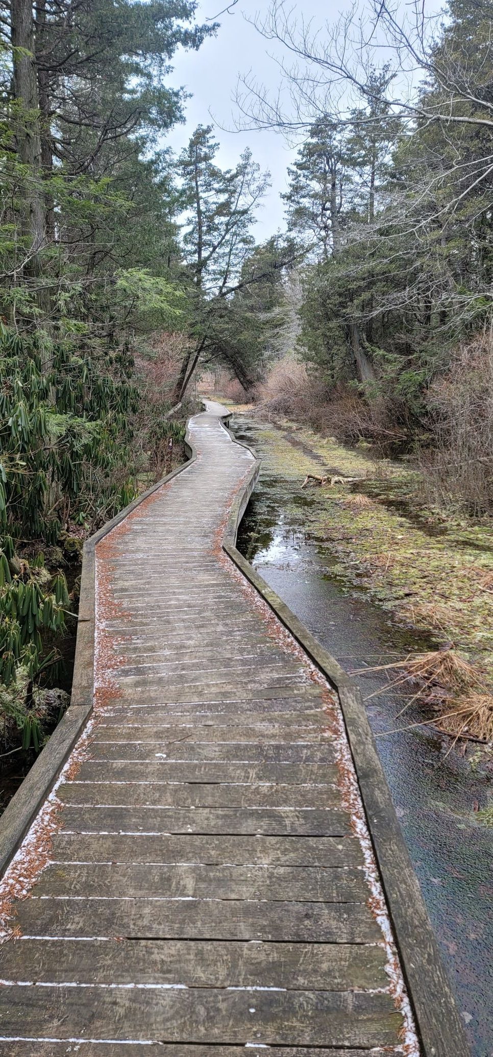 High Point State Park was cold and desolate. I didn’t see a single hiker the whole time. The trail meanders through the woods, crossing some wooden walkways over marshy areas. Deeper into the woods there are hunting blinds so I was glad to be hiking during a non-hunting season.
After a couple of miles, the trail crosses into New York and follows high above I-84 until it loops down to an underpass. Traffic was bad that day and there were many fast-moving vehicles on these road walks which did not feel particularly safe. After that, the trail goes into Huckleberry Ridge State Forest, a typical state forest land with hunters lodges and multiple stretches of railroad walking. It follows some forest roads and power lines until it pops out on route 211 near Otisville, NY. I walked right past the next turn up a steep hill on the left, with only a tiny trail marker up from the road. That’s actually been a reoccurring theme on the SRT, little to no trail markers, blazes that suddenly stop, and hidden trail markers. I suggest following a GPS route from somewhere like AllTrails or Strava, but be aware most are old and can lead you astray in sections where the trail was rerouted. Even following GPS, I had to check the route many times as the trail has a rather circuitous path that is not exactly intuitive; it’s easy to go the wrong way. The first day of hiking is not the most beautiful. It goes through some nice forest land, but the proximity to highways, railroad, and powerline walking took away from the beauty of the day.
Eventually, I made it to my first campsite at Gobblers Knob State Forest. It’s a small 303-acre parcel of land with private land boundaries nearby. If you choose to camp here be aware of primitive camping regulations, leave no trace principles and stay well away from the neighbors.
That night was my first time sleeping in my Solplex trekking pole tent and it was surprisingly easy to set up. It was going to be a cold night, with a low of 19°, but I was toasty warm in my new 0° Enlightened Equipment Enigma Quilt.
Day 2
Morning of day 2 was chilly but it was good motivation to maintain a brisk pace and warm myself up. The trail goes down to the beautiful wetlands of Bashakill Wildlife Area. It’s unfortunate you can’t camp here because it has nice trails, beautiful scenery, and very few people. I kept my eyes peeled for bald eagles and osprey, but I was not so lucky as to spot one. The trail follows the wetlands for ~6 miles until the town of Wurtsboro where there is some road walking. Then the trail unexpectedly dips into the woods once again at Wurtsboro Ridge State Park where it ascends the ridge proper. Here the landscape

starts to look more typical of the Shawangunk Ridge marked by Shawangunk conglomerate and pine trees. The trail here is somewhat rugged with lots of rocks, boulders, and roots. It goes down into a valley and then climbs up into Roosa Gap State Forest and then Shawangunk Ridge State Forest. This is the last area where you can camp before entering Minnewaska and Mohonk, so it’s a good place to set up for the night.
Thirty-eight miles in a day and a half had my feet, legs, and back aching. Even though my pack is pretty light with a base weight of 10lbs, every part of my body was feeling it. I started to regret not doing my training runs and walks with a loaded pack to prepare for that aspect.
Day 3

The third and final day was going to be a rough one. I started out at first light and moved quickly as the trail descends down to cross Route 52. Here you enter Sam’s Point Preserve, the southernmost section of Minnewaska State Park. I had never been on this trail before, so even though it’s a tough 1,500ft ascent to Sam’s Point, its very beautiful, secluded and I was excited to be there. I made a quick stop at the Sam’s Point Overlook and then scurried down to Verkeerder Kill Falls. Early in the morning having these areas all to myself was so peaceful and serene. I didn’t even let my poles tap the rock because I wanted to hear all the early morning sounds of nature.
After Verkeerder the trail goes past Lake Awosting, Murray Hill, Castle Point, and under Rainbow Falls until it takes the Jenny Lane out to 44/55. The trail in this area is so convoluted with lots of rock scrambling and even a spot that went through narrow, dark cave. A couple of times I had to chuck my poles down a small cliff to be able to climb down with my hands.
Past 44/55 the trail follows High Peter’s Kill Trail past many waterfalls, up to Compass Rock and then down to the border with Mohonk Preserve. Once in Mohonk the trail is pretty boring, skirting the western edge of the preserve on a relatively straight 4

mile trail going north. Cross a couple more roads and up a hill to get to Spring Farm Trailhead for the last section of the trail. Here the path goes near Bonticou Crag, but to my disappointment, it doesn’t go up the rock scramble to the viewpoint on top of the crag. Bonticou has always been a favorite hike since my childhood, but I would have to skip it this time.
The trail ends at Mountain Rest Road near the entrance to Mohonk Mountain House. I have hiked in both Minnewaska and Mohonk all of my life, but this weekend I got to experience the trails in a different way. It gave me an ever greater appreciation for the beauty of this ridge and my hometown. And I felt a sense of accomplishment for having completed this trail.
The Results
After 71 miles in 3 days, I learned… I am not ready to hike that fast. It’s a sad realization for me, someone who considers herself perpetually fit and ready to go on any adventure. But I was hurting. I got 2 blisters, tweaked my left ankle, strained my shoulder, got chafing from my pack, and was overall exhausted at the end of each day. It was a good experiment because it reminded me to forget my expectations and remember to slow down and listen to my body. I’m sure the 20+ mile days will come soon enough.
I also learned….. I love my gear! I was resistant to trying a trekking pole tent, fearing it would be difficult to set up in a variety of environments, but I realized it’s not that hard. My Zpacks Solplex goes up quick, has plenty of room inside.

My sleep system, including my EE quilt and Therm-a-Rest XTherm pad, was plenty warm at 19 degrees. Another first for me was a frameless backpack, the Mountain Laurel Design 48L Exodus pack. It was super comfortable even when fully weighted with food and water. Much of my clothes, electronics, and first aid I had dialed in well before this trip so I already knew I loved those pieces. The only piece of gear that malfunctioned was my Sawyer filter. It was cleaned and stored for 4 months since my last trip, but it was totally clogged. Apparently, mineral deposits from hard water can jam up the system even after a thorough cleaning. This was easily fixed by running some vinegar through it when I got home, but it’s best to test your system before you leave. Good thing I had my backup water purification tablets. Or did I drink the local water?
So what changes did I make?
Honestly, the only gear changes I made was to order an extra 2L water bladder and some toe socks for the blisters. Everything else is staying. The only other changes were to remember to force myself to go slower until I get my hiking legs, and to remember to bring far less food than I think I will need. And then take out some food. My legs will appreciate it.
11 days and counting – I feel ready.

This website contains affiliate links, which means The Trek may receive a percentage of any product or service you purchase using the links in the articles or advertisements. The buyer pays the same price as they would otherwise, and your purchase helps to support The Trek's ongoing goal to serve you quality backpacking advice and information. Thanks for your support!
To learn more, please visit the About This Site page.
