 ">
">
Trail Update Number Seven; NorCal Blues Beauty!
Northern California gets a bad rap in the PCT world. Now before I get into it, please let me state for the record: I skipped a bunch of miles (you can read all about that in my Sierra series) and this is an exceptional year. Excess snow, super cold and tons of water in the desert, lots of rain throughout…my experience doesn’t match that of a lot of hikers. Still, there are some constants that exist for everyone who walks the trail. Hopefully my description of those will serve to change the reputation that seems to plague this section.
Back on trail!

After my nearly three week hiatus from the trail, it was time to get back at it! My cousin dropped me off where the trail crosses the road just outside of Old Station. My pack was still full from the resupply that was intended to carry me further through the Sierra. That and the fact that I hadn’t worn it for almost three weeks made it seem extra heavy. I began walking north again, excited to see what this leg of the adventure would bring. A few minutes into the walk, I came across the trail that leads to the subway caves. I literally had just gotten back on the trail and I was already diverting from it. At this rate, I won’t get to Canada until sometime in 2037! But this is one of those iconic places that you need to visit when on trail – and it doesn’t take long – so off I went. The caves are super cool inside (literally and figuratively) and the darkness seemed to swallow the light from my headlamp. It was really fun to think about how they were formed and later on down the trail, look at certain landforms and wonder if they were the same thing.

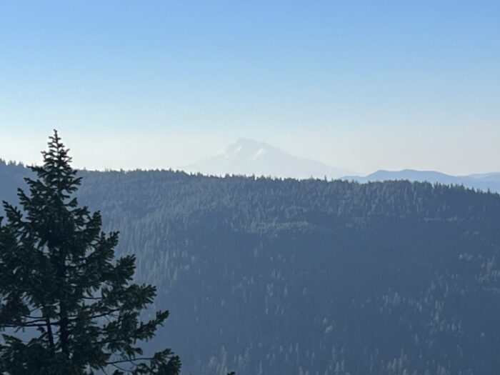
After the caves, I began the climb to the Hat Creek Rim. Just after reaching the top (now approximately 2 hours into my day) as I was passing the trailhead, trail magic! I felt bad taking any as I didn’t feel like I deserved it, but the people providing it insisted that I have something. Besides, beer and homemade bars? I think it would be a crime not to! I continued my walk along the rim until I found a suitable place to camp. I was maybe a third of the distance across the rim and the views were spectacular. I mean, where else can you see Mt Lassen to the south, Mt Shasta to the north and several other peaks in between? The next morning I was able to have one of those perfect PCT moments: sitting on an overlook, with beautiful views, in perfect weather and enjoying a snack. Regardless of mileage goals, it’s always worth it to take the time. I descended from the rim and got a small taste of the heat and rocks, but nothing too crazy. My mileage timed out so that I would be getting to the junction to the town of Burney near the end of the day. I didn’t need to go into town whatsoever, but the call of good food is strong! As I was approaching the road, I was checking my phone to confirm that I was in the right place, a car stopped and asked if I needed a ride! I couldn’t believe it. Another ride without asking? How is this possible! I gladly accepted and minutes later was in town and had accommodations for the night. Hiker towns really are amazing. I’m always impressed with how in tune to hikers and their needs the locals are. BTW, the trail angel who gave me the ride to town, also gave me their number and told me to call them when I was ready to head back to trail. Which of course I did! The next stop was at Burney Falls, a perfect lunchtime distance from town. It was fun to take some time to relax in another one of the iconic stops along the trail. It was nice and cool in the gorge and the sound of the falls drowned out most of the voices of the others who were visiting. Later that day, just as I was starting to feel the heat of NorCal kick in, more trail magic! This time in the form of a cooler of drinks and fresh fruit. Twice in three days. This now doubled the total amount of trail magic received compared to the desert! My next stop would be Mt Shasta which was still a few days away. In the meantime, I was enjoying walking through old growth forests and enjoying the plethora of water flowing in all of the streams. Also, aside from some sustained climbs, the trail was super easy walking so there were no worries about snow, blowdowns or navigation. It was great to be able to shut my brain off and simply walk – the reason I came out here in the first place.

The best trail magic came the day before I was to get into Mt Shasta. Sidebar: I’m from Wisconsin. I don’t live there anymore (sadly) but my heart will always be there, I’m a badger through and through! Anyway, there is a beer that you can only buy in Wisconsin brewed by a company that uses the same name as the town where they are located: New Glarus. So I got to a road crossing in the middle of the forest and a car was parked with the owner hailing me to come over. He offered me some watermelon and assorted other snacks, and beer. From New Glarus! As it turned out, the gentleman was from Wisconsin and was out there supporting his son who was also on trail. We talked for a while about all things Wisconsin and as it turned out, bikes as well! (Both of us are avid cyclists. (Please don’t question the logic of why I decided to walk for an entire summer!)). The beer was great of course, but even better was having that connection to home.

The day before I was to get in to Mt Shasta, it was threatening rain. I got to an alternate trail and had a decision to make. My original plan was to hike out to a section and camp, leaving a short distance into Shasta the following day. But as I sat at the intersection, looking at the Castle Crags enveloped in rain, having a snack and trying to make a final decision, a bolt of lightning struck not far from me. Decision made! I struck out down the alternate with gusto – which was just as well as now I would have town food! I reached the trailhead after hiking in the rain for about an hour. I had no sooner arrived when a car pulled up and asked me if I needed a ride. They said they have a friend who had hiked the trail last year and that tuned them in to other hikers on trail. They were kind enough to take me to town and would not accept any recompense. This was now the fifth ride I had received on the trail without asking! I’ve said it before but it’s worth repeating, I’m continually amazed by the kindness and generosity of complete strangers.
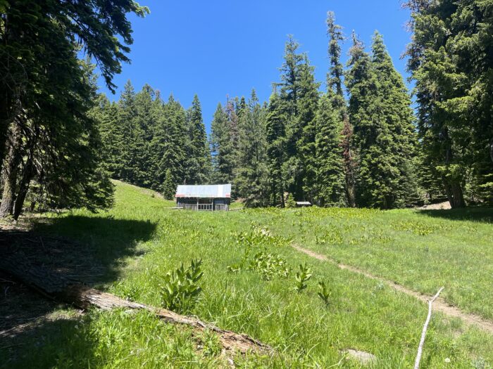
After a couple days in Shasta, it was time to get back to the trail. The next section would be some of the most beautiful scenery on trail thus far. It began with a few days in the Castle Crags wilderness. The rock formations throughout here were absolutely beautiful. It seemed like around every corner was a new and better view. Distant mountains, alpine lakes, jagged rocks, it just didn’t get old! The next section was through the Trinity Alps. Again, it was more scenery that defies description. Although it was also here that we encountered a bit of snow. It was nothing too sketchy, but enough to remind me of why I decided to skip ahead – I just wanted to walk, without having to think. Or should I say, walk without thinking about walking?

Following the Trinity Alps, was the Russian Peaks wilderness. Again, there was a small amount of snow to contend with, but the views of some of the mountains were the best yet. It was here that I had one of my favorite lunch spots on the trail. It was at the top of a long climb that curved slightly around a peak. I felt like I was sitting suspended out above the valley rather than looking across it. I spent a long time perched on a large flat rock just simply reveling in the fact that I was lucky enough to be there in that moment.

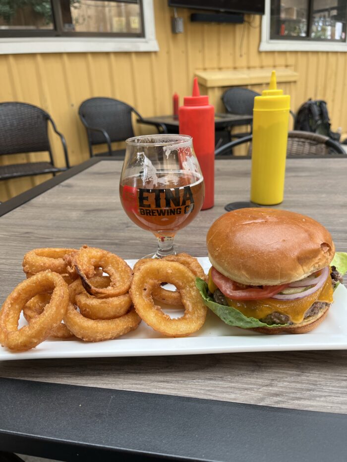
After getting through the Russian Peaks, it was time to take a short break from the trail in the town of Etna. As I was getting in to the final few miles of the day, thunder began rumbling and soon after, the rains began. And the wind. And the hail. But by this point I was on a ridge – definitely not the place to be in a storm so my only choice was to continue hiking. And hopefully decend before things got too crazy! I got to the trailhead and there were several vehicles parked waiting out the storm. It was a group of hikers that had planned to do a short section of the trail but were now weighing their options. I asked if they had plans to head in to town and while they weren’t sure about their final plan, they were more than willing to take me to there. As per usual, they were very interested to hear some of my stories from the trail thus far. It’s interesting to me how many people are genuinely curious about what we are doing, and yet to us it has just become…normal. Etna is a very small, yet very hiker friendly place. It has everything you need from creature comforts to resupply to a gear shop. Annnnnd if your package happens to be running late, it isn’t a bad place to take an unplanned zero!
After leaving Etna, it was time to head back to the trail. At this point we had a bit less than a week of hiking before reaching the Oregon border, but California still had a few surprises up her sleeve. First, the Marble Mountain wilderness. I sound like a broken record, but again, the scenery was simply stunning. Jagged peaks, flowing water, small alpine lakes, deep lush valleys and views that went on forever. Suffice it to say that there were a lot of “pinch me” moments. But it wasn’t all glory either. The descent into Seiad Valley had us going through what it still to date my least favorite section of trail. First, it was hot! The temperature that day hit 95 degrees, and being in a narrow canyon with lots of vegetation meant no breeze at all. Second. Overgrown foliage. At times, the trail was impossible to see and I was simply holding my hands in front of my face hoping I was traveling in the right direction and hoping not to trip over the many… Third: blowdowns! While not the worst section of blowdowns on its own (that would come the next day!), combined with the other factors made it a very unpleasant experience. The only saving grace was that it was downhill. I feel bad for the SoBos who will be dealing with this in the thick of summer!
I reached Seiad Valley in the late afternoon. It is one of those tiny rural towns that you wouldn’t give a second thought to if you were driving, but is a very important place as a hiker as it is the last stop before crossing into Oregon and the city of Ashland that is still several days away. The highlight of Seiad Valley is the RV park. It is very hiker friendly and the evening meal alone makes it worth the stop. It is freewill donation and done “potluck style” in the sense that attendees from the previous day are literally purchasing the meal for today and today’s attendees for tomorrow and so on. The ultimate hiker “pay it forward”. There is a large dining area and we all sat around the table like a big family. Tons of fun!
The following day I hiked out into the Northern California desert. It began with a climb that took several hours to ascend. However, we were rewarded with some spectacular desert scenery at the top with Shasta still in view. What made this day hard was the heat. The temperature topped out at 100 that day and no matter how much you drank, it was impossible to replenish body fluids. I took a long break that afternoon with some other hikers before tackling the final stretch of the day. It was only about four miles, but it gained over a thousand feet in that distance and there were a lot of blowdowns as well (we lost count after 100…). This was the most difficult section for me as the effort from earlier in the day had taken its toll and I struggled to get through. It seemed that California was trying to give me one last little jab before I left her behind! But, my efforts were rewarded with a ridge top campsite that had a view of Mt Shasta illuminated by the setting sun. Again, the trail provides.
The final day in NorCal was generally easy hiking. Smooth trails, and a combination of lush forests and beautiful views. California had shown me what it’s capable of. Harsh desert, high peaks, bitter cold, biting wind, intense heat, rain, snow, steep climbs, rough rocky trails, fallen trees…But it had also shown me beauty beyond description. Mountain ranges, old growth forests, streams with perfectly clear water, distant views, pastel sunsets and even better sunrises. And the people, some of the most kind and generous that I have ever met. Again (broken record) I am continually amazed by how many people are willing to give of themselves just to help hikers along on their journey.
So NorCal. It gets a bad rap in the hiker world. Perhaps it’s because most people have exited the Sierra and are now in scenery that isn’t quite as spectacular. Perhaps it’s the heat. Perhaps it’s the collective miles starting to take their toll. Or maybe it’s simply that by this point hikers are starting to feel a bit homesick and are already thinking about the end of their journey. Whatever the reason, I think they are selling it short. Northern California has a lot to offer anyone who walks through it and takes the time to admire what lies before them. If you are planning to hike the trail – and I hope you do – I invite you to slow down, pause at a stream, camp on a mountain, have lunch in a meadow or by a lake. Take the time to appreciate and enjoy what is there. The journey is hard, and each day will present some challenges. But each day will also present something wonderful, you just need to be ready to take it in. See you down the trail.


This website contains affiliate links, which means The Trek may receive a percentage of any product or service you purchase using the links in the articles or advertisements. The buyer pays the same price as they would otherwise, and your purchase helps to support The Trek's ongoing goal to serve you quality backpacking advice and information. Thanks for your support!
To learn more, please visit the About This Site page.

Comments 1
I think psychologically, once PCT hikers finish the Sierra, it feels like they should be done with California, and there is still a lot more left. Similarly, people think of Sacramento and San Francisco as Northern California, because they’re the last big cities before Oregon, but there is a LOT of California in between.