 ">
">
Pain Numbing Nostalgia
Just because I was in my home state didn’t mean that I was done with pain. After entering PA I hiked for four days before getting off trail to spend Labor Day with my fiancé and family. The elevation was tame but the rocks were just as bad as I remembered. I had hiked most of the PA AT before.. and each mile was nostalgic. I was in pain, but I was cruising through terrain that I use to think was difficult!
Day 66 (20.0 miles)
It was a bit of a rough night of sleep. I didn’t get to bed until close to 9:30 pm. Some people who arrived later kept me up, but that’s my fault for waking up before the crack of dawn! I still managed to get up at 4 am and get moving. I ate the other half of my calzone from the night before. The climb out of Delaware Water Gap wasn’t bad, but it was early in the morning and already hot and humid.

There were lots of deer in the area, but not a lot of water. The next few days would require water carries of 15+ miles. Hiking in the early morning saves a lot of water consumption and thus a lot of water weight that I would otherwise have to carry. Shortly after crossing mile 900 the rocks in PA began. They did not disappoint! Thankfully Maine and NH prepared me well for this and they were not as bad as I remembered.

I hiked with MG for most of the day. We crossed through Wind Gap and then climbed up to the ridge. I had just done this section the previous winter with one of my good friends back home. I remembered the nice view at the top and the campsite that we stayed at, which I planned to stay at again.

The Leroy Smith Shelter area is decent, but the water situation is not. MG and I hiked a half mile downhill to get to a stream that was flowing. We filled up all of our vestibules and then slowly made our way back to camp. Although the water situation in PA is bad, I was glad to be on familiar terrain.
Leroy Smith Shelter: T2, S3, P1, W4, B3
Total Score: 72
Day 67 (24.5 miles)
My feet hurt extremely bad this morning and all throughout the day. I honestly thought that they might get injured, but somehow they made it through. The morning was foggy and cloudy, a standard for PA it seems. We had a 17 mile water carry from camp to the first spring. We hiked past Blue Mountain Rd. which is a memorable place for me. This was where I first hitchhiked at the age of 15. This is where I met the German thru-hiker who ultimately instilled my desire to thru-hike that I have today. Unfortunately, this is also where I sliced my thumb badly and had to go to the ER. This is a place of fond memories that are both good and bad!

The ridge after the road crossing was relatively flat and easy. This section use to follow along an old logging road but is now rerouted through the forest. The area offers expansive views of the surrounding valley. At the end of the ridge is a short steep descent into the Lehigh Gap. The scramble down is one of my favorites in PA. It involves a few short exposed moves that get the blood pumping!


After the scramble, MG and I were walking on the easy path to the road. He stopped dead in his tracks but I couldn’t see what was in front of him. He then pointed to the Copperhead that was crossing the trail. This was the first wild Copperhead that I had ever seen and I was excited… too excited to take a picture when it was on the trail. I managed to snap one once it got in the brush, but it is extremely hard to see the snakes camouflaged body. I guess that is why this is the first time I have encountered one!
Shortly after the snake encounter we crossed the Lehigh Gap. The fog had lifted by this point and the heat had come on in full force. We crossed the Lehigh River and then headed up the other side of the mountain.

About half-way up the other side there was the first spring of the day. We were both soaked in sweat and took a long recovery break here. I considered staying the night at the nearby shelter. My feet were still in pain and didn’t seem to let up. I convinced myself to carry on. We met another Mountain Goat (who was doing a flip-flip hike) and his cute dog FrankE. The OG MG saw a bobcat shortly after we started hiking again. Something I never expected in the middle of the day!
A couple miles before the shelter there was a water cache on the side of the trail. A trail angel left multiple gallons of water and some apples for thirsty hikers. It’s worth mentioning here that PA law enforcement (Game Commission and Police) have been fining people for leaving water caches and dumping any that they find. They claim that they are dangerous because people could poison the water and they don’t want to have to expend resources to rescue poisoned hikers. Now which of the following scenarios seems more feasible: A) Thru-hiker dies from dehydration in PA’a heat wave or B) Thru-hiker dies from a thru-hiker murderer who took time out of their day to poison a water cache. I think we all can agree (minus the PA government) that scenario A is far more likely.

We hiked fast to the nearby shelter which had a dry water source. There was an impending storm. I quickly setup my tent and got ready for the night. MG decided to stay in the shelter which reportedly had a resident rat snake. I’m not a big fan of snakes, so I steered clear. The snake never showed up.. but something else did. I sat out the storm in my tent. Eating dinner and watching a Viking show on Netflix (enjoying nature). The rain was welcomed, hopefully it helps the drought.
Bake Oven Knob Camp: T1, S3, P1, W5, B4
Total Score: 60
Day 68 (17.5 miles)
Another 4 am foggy morning on trail, but today it was actually cool! The rain had drowned out the heat wave. I almost slept in a bit since it was colder and I had less ground to cover this day. The climb up to Bake Oven Knob was rocky and wet, not a great combination. I nearly ate it after a slip and slide down a rock slab. A few minutes later I ran into MG as he was navigating through the difficult terrain. He told me that he had a rough night of sleep. A porcupine came into the shelter in the middle of the night. It climbed all over the place and came very close to him multiple times. He watched the unafraid animal for 2 hours before it finally left and he could get back to sleep.


We got a bit off trail on the descent. The trail can be hard to follow during the day, but it is much harder at night. There was a lull in the rocks for a few miles while the sun rose.

We then came to the daunting Knife’s Edge. It slowed us down a bit, but it was nothing like I remember from when I did it in high school.

We were rewarded with consistent views of the still rising sun. Although PA is not the prettiest state on the AT, this morning was quite enjoyable!


I met up with MG2 and FrankE after a quick stop at the Thunderhead Lodge for water. We talked for a couple of hours while putting in some miles. It was great to talk to someone about the difficulties (and enjoyments) of having a dog on trail, as well as some tips on training stubborn huskies (a dog breed that my fiancé and I are very interested in owning one day). We took a break at a log and the OG MG caught up to us. The four of us then hiked to Eckville Shelter together. Along the way I took pictures of FrankE and we had a close encounter with a large black rat snake.


We arrived at the shelter just past 12:30 pm. The OG MG and I were done for the day, MG2 had some more miles to crush. He relaxed with us for a while and we chatted before he went on his way. Eckville shelter was another nostalgic place for me. On my first ever backpacking trip this shelter nearly “saved my ass”. My friends and I thought that we could purify all of our drinking water on a backpacking trip by boiling it over a fire. While this is possible, it takes a lot of time and effort for a very small output of water. By the second or third day we were all dehydrated and struggling. We came to a creek and some of my friends decided to drink the water straight out of it. I filled my water bottles but wanted to wait and use it only as a last resort. A mile later we came to the Eckville shelter, which has pure water from a spigot. I was saved but my friends were screwed. The following day they all got dysentery. I watched as they shit their guts out for hours. On our next trip we were sure to carry a water filter!
That afternoon was beautiful and relaxing. Finally a day that wasn’t scorching hot. The caretaker, Mick, gave us ice pops and soda! What a genuine dude. Towards the evening some other hikers arrived: Peacock, Visa and Yak. I caught up with them but went to bed shortly after sunset.
Eckville Shelter: T1, S3, P3, W1, B1
Total Score: 9
Day 69 (14.5 miles)
The OG MG and I woke up at 3 am for a sunrise hike to the Pinnacle lookout. The path from Eckville to Pinnacle is 5 miles of a wide logging road. Easy on the feet and even easier to follow at night. The stars were absolutely gorgeous for PA. Nearly every constellation was visible! We cruised through the miles and made it to the lookout well before sunrise. The horizon looked like a rainbow over the vast farmed valley.
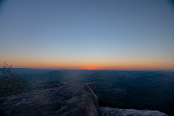
We stayed up there for over an hour and watched the sunrise. It was chilly in the wind, the sun was a welcomed sight. Pinnacle is another special place for me. It is my favorite lookout on the PA AT and brings me much joy whenever I am up there. I proposed to my, then, girlfriend at sunrise at Pinnacle this past March. Her first backpacking trip was through this area as well! I was elated to share this special place with the OG MG and I was happy to see that he enjoyed the view. It’s not the Whites or Southern Maine, but it’s got a unique character that I cherish.


We left the viewpoint around 7 am. It was another 9 miles to Port Clinton where I had a ride waiting for me. I remembered this section being difficult, it was not. I enjoyed the hiking this day. A couple more small views and lots of easy wide trail. We basically ran down the thousand foot descent into Port Clinton. At the bottom is a road off of a major highway. My fiancé arrived shortly after and picked us up. We resupplied at Walmart, got a meal, and then took a quick stop at Cabela’s since MG had never experienced one before. We then dropped MG back off at the trail and I headed home for some much needed R&R!
I hope you enjoyed this trail update. I’ve been loving my time in PA. There are many people that hate the rocks and the lack of beautiful views, but this section of trail is so special to me. Thanks for reading and remember to keep wandering in your own direction!

This website contains affiliate links, which means The Trek may receive a percentage of any product or service you purchase using the links in the articles or advertisements. The buyer pays the same price as they would otherwise, and your purchase helps to support The Trek's ongoing goal to serve you quality backpacking advice and information. Thanks for your support!
To learn more, please visit the About This Site page.

Comments 1
I met a Copperhead in almost the exact same spot about 25 years ago. At least going Southbound it is all downhill. LOL. Nice rocks. Good food though there in Pennsyltucky or Rocksylvania.