 ">
">
Potomac Heritage Trail 2023 Thru-Hike Trip Report
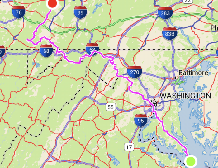
This report describes a 410 mile (elevation gain 11,485ft / loss 10,110ft) solo thru hike of the Potomac Heritage National Scenic Trail (PHT). My trek began on 22 May, 2023 and was completed on 9 June, 2023 taking me 17 days, 23 hours, and 27 minutes. My route can be broken into four sections:
- Section One began at the Point Lookout Lighthouse, Point Lookout State Park, MD and entailed an 85 mile road walk mostly along MD5 and MD235 until reaching Alexandria, VA where I hopped on the Mount Vernon Trail until reaching Washington DC.
- Section Two began in Washington DC on the Chesapeake & Ohio Canal Towpath (C&O) which is a 185 mile paved/gravel bike path ending in Cumberland, MD.
- Section Three began in Cumberland, MD on the Great Allegheny Passage (GAP) which is another paved/gravel bike path. The GAP is 150 miles long, spanning from Cumberland, MD to Pittsburgh, PA, however my trek only included the first 70 miles of the GAP, ending in Ohiopyle, PA.
- Section Four began in Ohiopyle, PA on the Laurel Highlands Hiking Trail (LHHT) and completed the last 70 miles of my PHT journey ending near Johnstown, PA.

Trip Planning Notes
There is limited information on thru hiking the PHT because there aren’t many people who have pursued it. I assume this is due to lack of an official trail association and the not-super-appealing 85 mile road walk. However, there is ample information available for Segments Two – Four individually, since the C&O and GAP are popular bikepacking routes and the LHHT is regarded as one of Pennsylvania’s finest hiking trails. The C&O, GAP, and LHHT websites all have maps and information on camping, lodging, and amenities along the way. I used Google Maps to plan out my road walk for Section One. I gathered additional information from @hikingamerica on Youtube and by reaching out to previous PHT thru hikers who provided me with a GPX file of the route. The PHT is extremely flat until the LHHT where the terrain transitions into a rugged hiking path, so I felt comfortable beginning my trek without physical training. I took a very relaxed approach to planning my distances, camping/lodging, and resupply points since I didn’t know how my body would feel. The close proximity and abundance of amenities along the trail allowed me the flexibility to plan day-by-day for most of my thru hike and kept my food bag light.
- Section One has plenty of options for food resupply, but the lodging situation is pretty wack and requires hotel stays since stealth camping is not permitted in this area. Depending on where you stay the night, the walk from California, MD to Waldorf, MD will be a 35-40 mile stretch without lodging options. I chose to take on the challenge, but it would also be easy to catch a ride to break up the walk.
- Section One is a combination of highway walking, rural narrow roads, with some sidewalks and bike trails mixed in. The highway, for the most part, has a wide shoulder to walk along, but it varies along the way. The rural roads are pretty narrow, with no shoulder, and a lot of blind turns. I advise avoiding Gardner Road if possible.
- The C&O has free first-come-first-served campsites (with nonpotable water and port-a-potties), lockhouses and camping (reservation and fees required), and in-town lodging well-spaced throughout the trail
- The PHT section of the GAP does not offer free camping, but there are private campgrounds and in-town lodging available.
- The GAP may require long water carries (15 miles) from town to town, but there are a few small streams along the way that may or may not be reliable
- The LHHT requires permits for the shelter/camping areas which are REALLY for a wee price of $8/night (as of 2023). Shelter/camping areas provide lean-to shelters with fireplaces and firewood, nonpotable water, pit toilets, and trash cans.
- There is a resupply point along the LHHT, I think it’s near Route 30, but I don’t remember since it was more than half a mile off trail and downhill, so I didn’t utilize it
My Trek:
- 22 May: Point Lookout Lighthouse, MD – Seaside View Campground, Ridge, MD, 9 miles
- 23 May: Ridge, MD – Sleep Inn & Suites, California, MD, 18 miles
- 24 May: California, MD – AirBNB, Waldorf, MD, 35 miles
- 25 May: Waldorf, MD – my friend’s house, Alexandria, VA, 20 miles
- 26 May: Alexandria, VA – Lock 21, 23 miles
- 27 May: Lock 21 – Marble Quarry, 22 miles
- 28 May: Marble Quarry – Cross Trails Hostel, 22 miles
- 29 May: zero day
- 30 May: Cross Trails Hostel – Killiansburg Cave, 15 miles
- 31 May: Killiansburg Cave – Jordan Junction, 26 miles
- 1 June: Jordan Junction – Leopards Mill, 29 miles
- 2 June: Leopards Mill – Purslane Hill, 28 miles
- 3 June: Purslane Hill – Evitts Creek, 23 miles
- 4 June: Evitts Creek – Trail Inn Campground, Frostburg, MD, 20 miles
- 5 June: Frostburg – The Hostel on Main, Rockwood, PA, 28 miles
- 6 June: Rockwood – Ohiopyle State Park Kentuck Campground, PA, 30 miles
- 7 June: Ohiopyle – Grindle Ridge Shelter, 25 miles
- 8 June: Grindle Ridge Shelter – Route 30 Shelter, 22 miles
- 9 June: Route 30 Shelter – End of LHHT, 23 miles
I’m very content with my thru hike of the PHT, and honestly it went way smoother and was more enjoyable than I anticipated. Not that I was assuming miserable chaos, rather I was entering the situation with an open mind since only 70 of the 410 miles are what one would typically imagine a backpacking trip to be. There were ups and downs, but that’s the case with all things in life.
Section One:
Although I don’t mind road walking, I wasn’t really looking forward to it, especially since the spacing between towns is kind of weird. However, I was excited for the challenge and had fun kicking into mission-mode to complete my 35 mile day to Waldorf, MD. Walking on flat pavement, wearing shoes that already had 300 miles of wear-and-tear, and jumping into big-mile days right away was not doing my ankles and knees any favors. I thought it would be pretty chill since it was 85 miles of flat ground, but I feel like it’s more difficult to walk on monotonous terrain because it felt like my heels were getting jackhammered into the asphalt. Plus, it was HOT. I think the 85-95 degree heat and sun exposure is what I struggled with the most. I felt like I was cursed because somehow I was in full sun all day every day with the shade mocking me on the other side of the road. As a proper corn-fed Wisconsin gal, I’m built for surviving the winter, not doing strenuous exercise in the heat, so I was struggling to figure out the homeostasis thing. Oh, and I was pretty dehydrated, wasn’t eating enough, and burnt the heck out of my calves on day three and fried them some more over the next few days. I really set myself up for success there.

My body was mad at me because on top of all that, I ended up running a few miles each day out of necessity. I felt comfortable walking along the highway because, although it was noisy and not super scenic, there was at least a shoulder to walk on (which some people think is another lane). At first I was excited to get away from the chaos of the highway, and I was having a great time walking past quaint farms and Amish buggies, but then the road would transform into a very scary series of blind turns with massive pickups and dump trucks whipping around blind corners. This is where I deployed the running legs. It was exhausting, exhilarating, and anxiety inducing all at the same time. However, I found a very effective way to alleviate said anxiety; you just gotta do that one hand signal school kids do on the bus to get semis to toot their horn. Man oh man, even as an adult, that dopamine boost is so so so good.
I thought I was going to be kind of bummed about staying in hotels, but it was a major relief to finish a big day and be able to eat town food, not have to set up camp, enjoy running water and electricity, and pass out in a comfy bed. My wallet, on the other hand, was not a fan of this plan. Due to the restraints of my small ski-bum funded budget, my self-supported Fastest Known Time attempt quickly became a supported hike since I crashed at a friend’s place instead of another hotel.
Once I got to Alexandria, it was smooth sailing until the C&O Canal. Alexandria is a super pedestrian friendly city, and the Mount Vernon Trail was an amazing change of pace after road walking. Ultimately, the side of a road is not my go-to adventure spot, but I had fun being a roadside attraction for a while. Plus, there were poppies blooming, beautiful farmlands and forests, and a surprising amount of wildlife. Neat.

Section Two:
After some reflection, I realized the C&O Canal hosted some of my favorite memories of the PHT. I wasn’t sure what it would be like on this 185 mile stretch, given it’s a heavily traveled bike path that’s relatively close to civilization, but this is where I saw the most wildlife and some of the most spectacular views. I loved walking along the Potomac River. It’s absolutely beautiful, and it’s home to so much wildlife: cranes, herons, pileated woodpeckers, snapping turtles, frogs, deer, squirrels, foxes, otters, etc. I found myself starting my days around 6:00 AM, right as the sun was rising, trying to get going before the sun would scorch my poor ill-adapted bod and while the critters were still up and about. I had countless Snow White moments–the best one involving three adorable baby foxes wrestling on a lock. I truly felt at peace listening to the birds and frogs chirping in the early morning, sunlight peeking through the trees kissing my cheeks while I sipped my weird chia seed brownie mix breakfast shake concoction. The old canal has been transformed from a mode of transportation into small lively ponds reclaimed by nature.

I had no problem keeping my food bag nice and light on the C&O. Carrying more than two days worth of food on this trail would be silly unless you have tricky dietary restrictions. As a vegetarian, I didn’t have any issues finding things to eat, granted I was defaulting to Sheetz loaded tater tots half the time, haha. There are concession stands in the Historic Parks along the trail and plenty of towns right off the trail; half of the dinners I ate were at local diners and gas stations a few blocks off trail. My favorite stop was probably the Schoolhouse Kitchen in Oldtown, MD. Just as the name would suggest, it’s a cafe inside of an old school cafeteria. Solid retro vibe inside with old class photos on the walls, a refrigerator filled with desserts, and some resupply options available. I ended up getting a salad, a slice of chocolate cake, and a side of fries while I charged my phone and rested my legs. The employees were super kind, and I was stoked to enjoy some air conditioning before setting out for another 15 miles in the 93 degree heat.
The C&O has free hiker/biker campsites all along the trail. Each site has a port-a-potty, a nonpotable well, fire ring, and picnic tables. Many of the sites overlook the Potomac River or are near the old locks and lock housesuses. One of the best sites I camped at was Killiansburg Cave. I set up my hammock right along the Potomac River, and got to wake up to the sounds of birds chirping and fish flopping around in the water. Once I got moving in the morning, I explored the nearby caves–I didn’t see any, but apparently there are a bunch of bats that live there.
I got the opportunity to stay at my favorite hostel on the Appalachian Trail, Cross Trails Hostel, once I got to the Harpers Ferry area (near mile marker 58). This is where I took my first and only zero day on trail. I got to hang out with some of thru hiker homies and meet this year’s class of Appalachian hiker trash. I don’t know what it is about this place, maybe it’s the quality company and good vibes, but I always feel restored and renewed when leaving Cross Trails. If you’re in the area, I HIGHLY recommend stopping by. Camping, bunks, private rooms, full kitchen, AC, tubes for floating down the river, and good vibes all around.

Most nights, I had the entire campsite to myself, if not, three other people maximum. This was a surprise to me because I figured it would be quite busy, but I think most of the people bikepacking the trail tend to stay in town rather than camping. It was interesting because during the day the trail was quite populated, but I felt very isolated because most of my interactions were bikers warning me with, “on your left” before passing (if they said that… There may or may not have been many scenarios where bikers appeared out of nowhere scaring the poop out of me, and sometimes getting too close for comfort. This is very scary because I could have been bonked off the trail into a pond of stagnant water resembling pea soup).
Section Three:
My general consensus of the GAP is that it was nice, but I do think it would be a lot better on a bike. The GAP is a part of the Rails-to-Trails Conservancy which means the trail follows the railroad tracks. The towns along the GAP are spaced out every 15 miles which also means there are some long water carries along the trail. I was able to refill my water in a few spots where runoff was flowing from the recent storm, but I still found myself rationing since I didn’t know where the next water source would be. The heat, full sun exposure, and lack of water were definitely a bit of a struggle. The water situation and the stretches of homogenous, yet beautiful, views are the main factors making bike travel superior for this section.

Since there wasn’t free camping available, I camped and bunked in quaint little towns along the trail. Once again, I was able to get away with a very light food bag since each spot I stayed had plenty of resupply options. I think my favorite stay was in Frostburg, MD at the Trail Inn Lodging and Campground. I set up my hammock in the yard, washed the nasty off my bod, got some killer Mexican food, and then resupplied at the gas station. However, I must warn everyone that my campsite neighbor had all of his clothing stolen by the local racoons. He set them out to dry in the sun, and then wandered around town until he found the scattered articles. He told me, “the racoons keep all the good stuff on the porch of the hotel”, so if anyone ends up camping here and your stuff goes missing, you know where to check.
Section Four:
All of the locals I chatted with along my journey told me to look forward to my time in the Laurel Highlands. According to the internet, it’s “one of Pennsylvania’s finest hiking trails”, but with my only experience hiking in Pennsylvania being the Appalachian Trail, I didn’t really know how to interpret that statement. But hey, it was awesome. I was lucky and got to experience the mountain laurel in full bloom and the views were beautiful despite the smoky haze, but what really stood out to me was the camping/shelter areas. It cost me $8/night to reserve a shelter spot with a fireplace, wood provided, camping platforms, nonpotable water, pit toilets, and garbage cans. It was so cozy and would make for an awesome fall backpacking trip. Apparently, the area is known nationally for epic fall colors, or so I’ve been told by the locals

I decided to hike the 70 mile trail in three days because I heard word of an ultra marathon that would be taking place on June 10, and I wanted to avoid herds of humans on the trail. This became more challenging than I anticipated because I was starting to feel sick–I probably wasn’t eating enough while pushing my body too hard resulting in my poor immune system being overworked and underpaid. The poor air quality due to the Canadian wildfires didn’t help my situation. My second to last day on hiking was probably one of the most difficult days I had on trail. I felt light headed, had a mucusy cough, hot flashes, cold sweats… I was feeling like a Victorian child. Thankfully, I didn’t feel like death the entire day, but it was difficult mentally and physically to hike 22 miles in the heat. I don’t remember that much from that day, probably because I was boiling my brain a bit, haha. Needless to say, I was grateful for the fireplace stocked with wood when I got to camp, especially since it started downpouring moments after my arrival.
My last day on trail was fueled by a bagel topped with raw garlic and watered down hot sauce, oatmeal, and two pounds of baked beans, just as the experts suggest. I finished out the last 25 miles of trail feeling way better than I did the day prior. Thank goodness because I was worried that I would have to hop off trail for a bit, which would really suck being so close to the finish, but I made it! However, neglecting my immune system resulted in me dealing with a respiratory illness for another two weeks post trail. Wamp, wamp, wahhhh. Aside from my physical health, I was feeling good and feeling proud of myself for completing my thru hike of the PHT. My friend gave me a ride to Johnstown, PA where I purchased the very last hotel room in town–there was a Jahova’s Witness convention, so I was forced into a life of luxury at the Holiday Inn. From there, I loaded up on some gas station snacks where an old man warned me of my future damnation and gangrene (because of my “excessive tattoos”?), relaxed in the hot tub, and rested up before hopping on the train the next morning. And just like that I was on to my next hiker trash adventure.


This website contains affiliate links, which means The Trek may receive a percentage of any product or service you purchase using the links in the articles or advertisements. The buyer pays the same price as they would otherwise, and your purchase helps to support The Trek's ongoing goal to serve you quality backpacking advice and information. Thanks for your support!
To learn more, please visit the About This Site page.

Comments 1
Beans, my husband Bill Niedringhaus and I would love to talk with you sometime! Bill is President of the Potomac Heritage Trail Association and I am a board member of the Potomac Heritage Trail Association. We are a non profit and our mission is to build, maintain and advocate for scenic routes for the Potomac Heritage National Scenic Trail! Enjoyed reading about your thru hike! Please call us at 703-638-3218 or email at [email protected]. We would love to hear from you!
Walk on!
Karen L Jones
Potomac Heritage Trail Association
Fairfax Trails and Streams