 ">
">
A Thru-Hike for Everyone (Part II): 5 Trails Over 200 Miles
For those who don’t have the time or interest in undertaking one of the Triple Crown Hikes, plenty of other options for thru-hiking exist. There are long-distance trails that provide incredible experiences and can be completed in weeks rather than months. Below are just a sample of some trails that are epic enough to be life changing, but don’t require the time commitment of one of the country’s more famous trails.
This is Part II, trails over 200 miles. Check out Part I below, with five options for thru-hiking trails under 200 miles.
Superior Hiking Trail
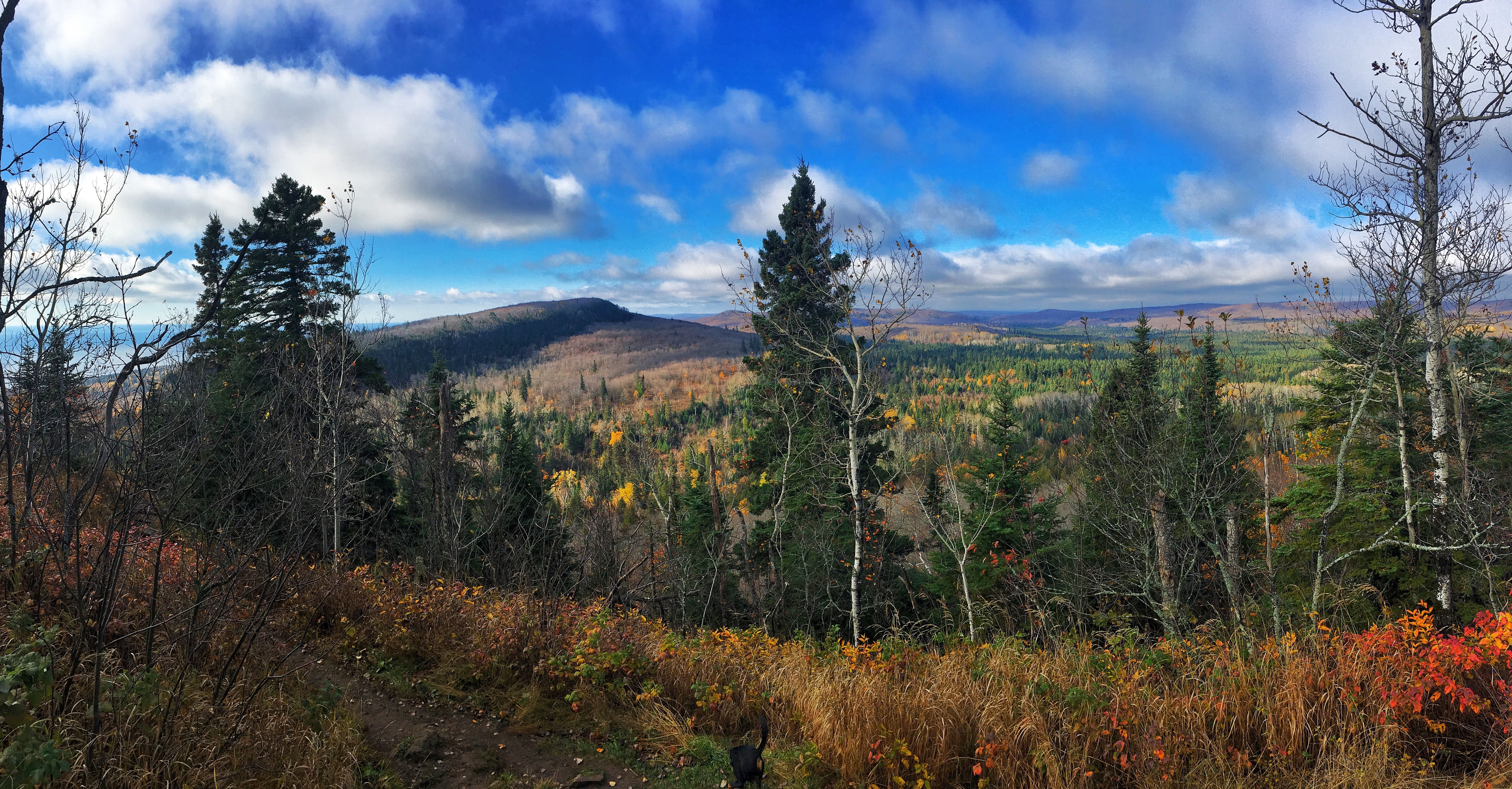
Photo courtesy of the Superior Hiking Trail Association
Best For: Hikers looking for a north woods experience with surroundings reminiscent of the Boundary Waters Canoe Area, but with a really big lake involved.
Distance: 255 Miles
Location: Along Lake Superior, north of Duluth, Minnesota
Getting There: The southern terminus for a “traditional” thru-hike is the Martin Road Trailhead. From I-35, take 21st Ave. East Exit #258. Turn left on 21st Ave. E. and right on Woodland Ave. Turn right on Snively Rd. and continue straight on Jean Duluth Rd. Turn left on Martin Rd. to trailhead parking lot. Overnight parking is allowed there. Two shuttle companies can be contracted as well.
Description: The Superior Hiking Trail (SHT) runs generally along a ridge above the north shore of Lake Superior. The linear route travels nearly to the Canadian border from the northern city limit of Duluth. The trail actually continues 41 additional miles south through the city towards the Wisconsin border. However, as no backcountry camping is allowed through this stretch, it is not considered to be part of a “traditional” thru-hike.
A main highlight of the trail is the nearby presence of the big lake the Ojibwa people called Gitchi Gami (Big Water). And big it is, the largest freshwater lake in the world. Stunning views of the water are common. Numerous streams and rivers flow into the lake and the path is often situated to provide a view of a spectacular waterfall as the flow drops off the ridge down to the lake.
There are three forest habitats along the trail including the Boreal Forest featuring birch, fir and spruce. The woods provide habitat for a variety of animals including deer, moose, beaver and bear. Less often seen, but in the area are wolf, lynx and even mountain lion.
The trail itself doesn’t have huge climbs. The lake sits at around 600 feet above sea level and the high point on the trail is a bit over 1,200 feet higher. Don’t let that fact lull you into thinking the trail is easy however. Hiking is rarely on flat ground with steep elevation changes between river valleys and ridgetop.
There are no permits or fees to hike the trail. Campers are required to stay at the established backcountry campsites. With 93 available, finding a spot for the night should not be an issue though. Each site offers multiple tent pads, fire ring and a latrine. Typically, a water source is nearby. A great time to hike the trail is September/October; after the crowds and bugs, but before the snow flies. Start planning a trip at shta.org.
Long Trail
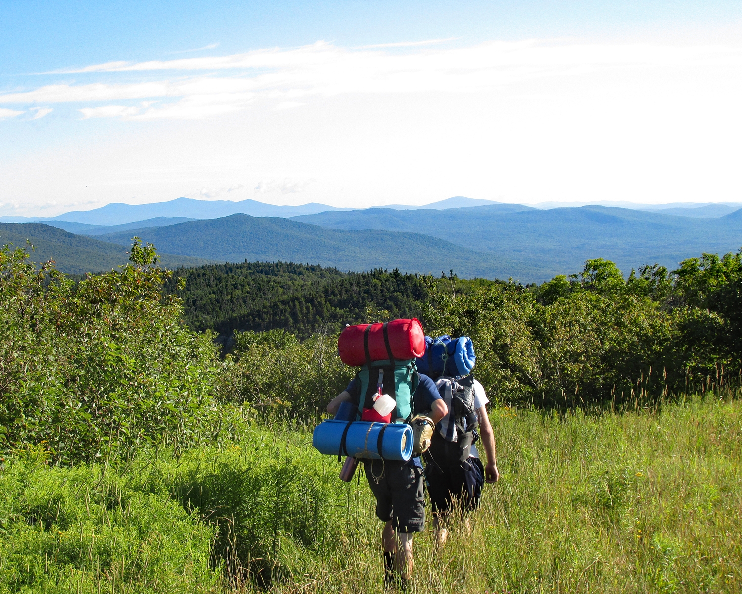
Photo courtesy of Jim Rahtz
Best For: Those wanting an AT-type experience in a smaller portion, but also don’t mind a significant challenge.
Distance: 273 miles
Location: Vermont, running from the Massachusetts border to the Canadian border.
Getting There: The southern terminus of the Long Trail is located on the Appalachian Trail at the Vermont/Massachusetts border. The trail can be accessed via the AT by hiking north from the crossing of Mass Rt 2 between Williamstown and North Adams, MA. Another option is to hike the Pine Cobble Trail from Pine Cobble Rd in Williamstown to the AT just south of the Vermont state line.
Description: The oldest long distance hiking trail in the U.S. very much provides an AT type experience as, during the southern 104 miles, they are actually the same trail. There are the same shelters, blazes, plentiful resupplies and social community. While the shelters can be crowded, I recall one young hiker telling me how wonderful that experience was for her. “Even though I’m hiking alone, I never feel alone.”
The LT follows the very spine of the Green Mountains and provides some great views along with some significant elevation changes. Once north of the split with the AT however, be prepared for a steeper, rockier, more challenging hike; with a lot less company. The climbs up and down mountains such as Camels Hump and Mt Mansfield were where I discovered that backpacking could be an adrenaline sport. Do not underestimate the challenge of this trail. I fell more on the LT than on all other hikes I’ve taken in my life combined. One backpacker I know fractured her skull on the LT. Oh, and the famous “Vermud” is a real thing. With great challenge comes great reward though. Start gathering information at greenmountainclub.org.
Sheltowee Trace Trail

Photo courtesy of Jim Rahtz
Best For: Midwestern or mid-southern hikers looking for a trail with surprising ruggedness and few crowds.
Distance: 323 miles
Location: The trail runs from Big South Fork National River & Recreation Area in Tennessee to the northeast corner of Kentucky.
Getting There: To get to the northern terminus, take I-64 approximately 50 miles east of Lexington, KY to exit #137. Start north on Rt 32 then right on Rt 377 to the trailhead. If you’re starting at the southern end, the best plan may be to park at the Bandy Creek Visitor Center in the Big South Fork, pick up a camping permit and have a shuttle arranged to the terminus. From Oneida, TN, turn west on Rt 297 from US 27 to signs to Bandy Creek Recreation Area.
Description: “Kentucky’s Long Trail” is named for Daniel Boone, who was given the name Sheltowee, or Big Turtle, when adopted into the Shawnee tribe. The trail features numerous waterfalls, natural arches, sandstone cliffs and tremendous views. It even passes by a spot where clear skies and a full moon generate a moonbow. Sections of the trail are located in Big South Fork National Park, Daniel Boone National Forest, Cumberland Falls State Park, Natural Bridge State Park and Red River Gorge. Originally completed in 1979, the path is administered by the Sheltowee Trace Association (STA), and is still being extended and improved. For a trail not located in the “mountains,” it is surprisingly rugged with impressive overlooks.
More so than many, this trail can be hiked year-round, but with the usual caveats: possible cold and ice in winter, high water in the spring and heat and bugs in summer. As often the case, fall is a good time for a thru-hike. Another option for thru-hiking the trail is the Hiker Challenge. The Sheltowee Trace Association has set up a program where a hiker can complete the trail by hiking one weekend a month for 11 months. All shuttles, camp locations and camaraderie are provided for you; all you need to do is show up, hike and enjoy the show. Begin your investigation of the trail at sheltoweetrace.org.
Colorado Trail

Photo courtesy of Jim Rahtz
Best For: Independent, self-sufficient hikers looking for a challenging big mountain experience.
Distance: 486 miles
Location: Colorado running between Denver and Durango
Getting There: The Colorado Trail Eastern/Northern terminus is located at 11300 Waterton Road, Littleton, CO. From Denver, take I-25 South to C-470 West to CO Hwy 121 South. After 4.5 miles turn left onto Waterton Rd.
Description: In a word, epic, though I may be biased as it was my first thru-hike. During its nearly 500 mile length the CT averages over 10,000 feet in elevation, travels through eight mountain ranges, six wilderness areas, some of the prettiest scenery in the Rockies and has the best hiker shuttle ever (an antique train). Long stretches have relatively few other hikers and convenient resupplies can be 100 miles or more apart. I spent significant portions of the trail with a successful AT thru-hiker. Everyone has their own perspective, but between the elevation and lack of support structure, she felt for her, that the CT was actually a more difficult hike.

The CT is generally snow free July through September. Days typically start out sunny, but thunderstorms often build up in the afternoons, which can be of concern above tree line. The trail is well constructed with most creeks bridged and switchbacks where needed. There are no permit fees required and no shelters provided. Start planning your hike at coloradotrail.org.
Florida Trail

Photo courtesy of the Florida Trail Association
Best For: Those looking for a long thru-hike with southern scenery and wildlife, as well as no cold weather or mountains to deal with.
Distance: 1,100 miles, but varies depending upon options.
Location: The trail runs from near Miami north and west into the panhandle of Florida south of Pensacola.
Getting There: The southern terminus is at the Oasis Ranger Station on US 41 about half-way between Miami and Naples. The northern terminus is at Fort Pickens in the Gulf Islands National Seashore south of Pensacola.
Description: There’s a surprising variety of habitats to explore along this trail, from oceanfront to swamp, prairie and old growth forests. Wildlife varies as well, from sea turtles to Florida panthers. Most hikers start in the south with January being a prime time to begin. The trail is still being improved and taken off road, with 300 miles of road walking left to contend with.
Several permits are required to thru-hike as there is travel through and/or camping in state forest and parks, an air force base, the Seminole reservation, a national wildlife refuge, national seashore and more. The Florida Trail Association has put together an entire packet to assist with the planning process.
Featured graphic courtesy Katie Bumatay

This website contains affiliate links, which means The Trek may receive a percentage of any product or service you purchase using the links in the articles or advertisements. The buyer pays the same price as they would otherwise, and your purchase helps to support The Trek's ongoing goal to serve you quality backpacking advice and information. Thanks for your support!
To learn more, please visit the About This Site page.

Comments 5
Come to Arkansas if you ever get a chance we have a couple long trails that fall into both categories: The Ozark Highland Trail at 165 miles and the Ouatchita National Recreation Trail at 223 miles. They are both wonderful trails.
Agree with Matt. The Ouachita Trail in Eastern Oklahoma to just west of Little Rock is great, no FABULOUS! 223 miles. From west to east it has wonderful, brand new shelters about every 8 to 12 miles…as good or better than any shelter I experienced on the AT in Georgia when I did my section hike. One time in a driving rain that shelter looked more inviting than the Ritz-Carlton, and I woke up to an amazing and blazing sunrise over the mountains. Close drive from my home in Dallas. Great community supporting the trail, well marked, and good shuttle services throughout. If I am “Jones’n” for a getaway, whether a day, a weekend, or a week or more, this is my “go-to” trail. You can also get the complete Ouachita Trail on guthook.
You guys have me thinking about the Ouachita for next year; sounds pretty interesting. I’m not normally big on electronics while backpacking, but if Guthook is available, that’s a real plus for me. It has saved me from wandering aimlessly more than once.
Thanks for providing these suggestions, and to the commenters mentioning Arkansas. After visiting Shenendoah and Harper’s Ferry, I became somewhat obsessed with hiking the AT. I am 43, and have never done long hiking in mountains. My kids will be in college in three years, so maybe if I hike some of the trails you suggest will help prep me for my goal!
This is a great website, and I appreciate the work that goes in to these posts!
Lisa,
Glad you found the post useful. Hopefully three years gives you enough time to hike one or more of these trails. Nothing gets you prepared for taking a long hike quite like taking a (not quite so) long hike.
Jim