 ">
">
AT Day 101 – Flat As A Bar Of Soap
Safford Notch Campsite to Kennebec River
Where’s The Water? Camp to In Need Of A Ship Camp
AT miles: 26.4
Total miles: 2045.7
Elevation change: 3819ft gain, 5531ft loss
A day of flat walking, just what I needed. The fabled ease-up of Maine finally arrived today after spits and spurts of easier terrain teased me between small sub-ranges of tough mountains. Baldpate, Old Blue, Saddleback, Sugarloaf, Crocker. The Bigelow’s were the final obstacle between me and the trail of my dreams, and I finished up that rocky traverse this morning before plunging into the endless sea of mud, ponds, and maple. It seems strange now, at the end of the long day, to think that just two weeks ago, I would have called a day like this one boring. The views were not grand, the hiking monotonous, yet after having my fill of the spectacular and challenging in New Hampshire and Southern Maine, it all felt right. Different, familiar, and right. My legs ache from the effort of distance, not of mountains climbed. My mind is tired from a day with nothing to do. My ankles itch with the memory of a dozen mosquito bites. I’m positive that I would lose my mind in this green tunnel if it continued for a month, but for one day, and probably a few more, it was just what I needed to help me remember my stride and turn inwards as the end of my AT approaches. The final week? One day at a time, please.
The muck splashed on my tent told me that I had slept through a lot of rain during the night. As I tried to wipe it clean while rolling it tight, my hands became covered in small bits of dirt and forest detritus, which I then smeared onto my shorts. It seemed that the forecast had been right about that much at least. However, contrary to the rest of it, the morning was bright, if not clear, and dry so far. I had expected to be packing up in the rain, so dirty hands were nothing to complain of.
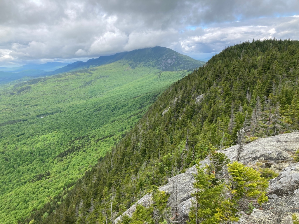
I hiked out of camp and back to the trail across boulders slick with humidity. I actually would have preferred a little rain (just a little) to this sticky mugginess, but I didn’t dare say that out loud. The rain would come, I was sure, and it was likely to give me more than my fair share. The dense jungle of the deciduous forest gave way to the dense jungle of spruce and moss as I picked my way up roots and rocks to the ridge of Little Bigelow Mountain. By the time I realized that I missed my water source, it was too late to turn back, so I gulped a mouthful of what remained from last night, then hiked on, trying to breathe through my nose. There was nothing else to do. I poured sweat, as I seemed to do a lot these days, but finally caught a light breeze from a viewpoint near the low summit. The bigger Bigelow’s were capped in glowing cloud, as were Sugarloaf and Crocker across the valley. The sky was mostly filled with a varied cornucopia of gray shapes and hues, but a few bright patches had me hopeful that the rain would not be as continuous or violent as predicted. The birds in the vast forest below sang their little hearts out, and I smiled at the twittering cacophony. It sounded carefree and belligerent, like there was nothing more important in that moment than filling the world with music. Of course, the concert was not performed for my pleasure, and probably had some practical purpose driving it. Not that I would ever know.
I slipped and slid with alarming consistency down the other side of Little Bigelow on slanted slabs of seemingly textured stone. I couldn’t explain why today I had soap on my feet, but it was a theme that would continue. Not for the last time, I ended up on my butt, wondering how that step of all steps didn’t work out. More often, I stayed on my feet while a foot skated uncomfortably a few inches before catching on the next protuberance. The slips continued even after the trail flattened out in the lowland forest, but I was getting used to them at this point, trusting no step. I drank my fill at the next stream, then topped off my bottles again for the long, flat walk ahead.

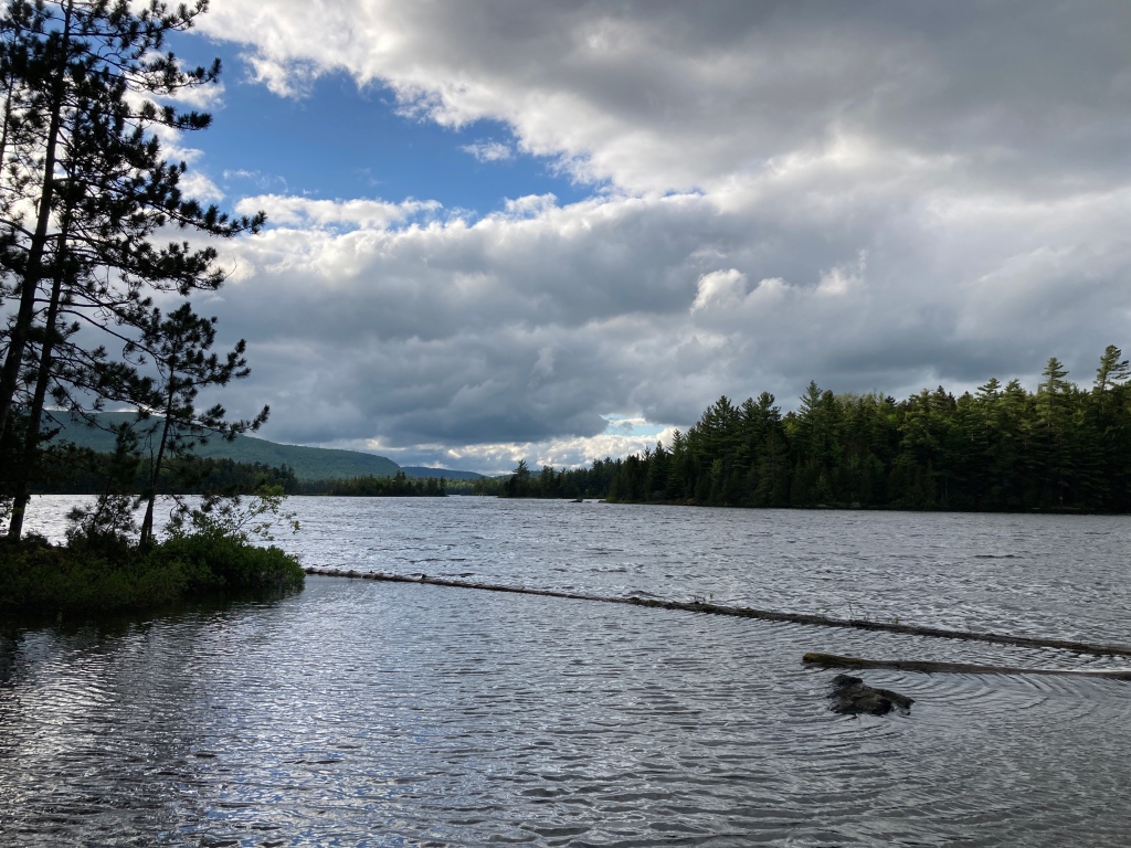
The trail was smooth as it closely followed the shoreline of Flagstaff Lake, and I languished in the gorgeous breeze blowing off the water for as long as I could. It cooled my sweat and kept the bugs grounded. But then the trail turned east, up a hill just steep enough to have me sweating again in no time. The leaves were dense, and although I heard the wind in the treetops, the air was still and thick at my level. I breathed it in. I exhaled. Both in and out, it was hot and humid.
A slight down carried me to the bottom of another slight up. These gentle grades typically would not have registered as landmarks, but without views, they were how I gauged my progress north. I knew that this second hill was a little larger than the first, and that it would be pretty much downhill for the rest of the day after the top. And like the first, this hill was just steep enough to see me drenched in sweat and swarmed by mosquitoes anytime I slowed to dodge a mud pit or downed tree. When the sky darkened, I thought it might finally rain on me and release this sticky tension hanging in the air, but the gloom passed with nary a drop that hadn’t squeezed from one of my own pores.

There was a choppy wind swell crashing along the rocky shore of West Carry Pond. The water was flat gray to match the sky, yet it moved with a random energy that spoke joy to me. The breeze was a welcome relief as well. I stopped at the nearby shelter for lunch, and filled my belly with spicy chips, dried fruit, and trail mix. While I munched, the sky finally let loose, unleashing a terrific downpour without prelude. It thrummed on the corrugated roof and collected in milky puddles around the perimeter. I watched, happy as a clam, smug and thankful.

The diluted memory of the rain dampened my sleeves and legs as I pushed through the dense bushes and baby trees over to East Carry Pond. I was deep in the forest now. The flat trail and sucking mud were no longer novel. It was all I had ever known. I swatted my face automatically and kicked my ankles together if I felt the shadow of an insect. Then a flashing blur in the corner of my eye. A squawk and thumping wings. I thought that I had scared a grouse up into the trees, but this bird had a different look. I eyed it. It eyed me. Then it squawked some more and made another plunge at my head. I ducked out of instinct and couldn’t tell you if it were necessary or not, but this bird seemed out for blood. It dove at me again and again, fortunately always announcing each charge with another squawk. I must have been close to its nest or something. Each time I felt the woosh of the air as it passed, each time I was grateful to still have my eyes. I hiked as fast as I could with nervous looks over my shoulder. One last swoop, then quiet. Now that was crazy. Not so monotonous after all.
Every surface felt like wet soap as I slid down to Pierce Pond. There, I stood in the wind, relishing the respite from the mosquitoes and appreciating my vision. I then crossed the knee-deep outlet and followed the logically named Pierce Pond Stream through a narrow canyon as it tumbled and churned over numerous cascades and waterfalls. My legs ached in a way that they hadn’t in two weeks. This was the deep bone-ache of long miles, not the burning fatigue of steep up and down. I had almost forgotten this satisfied discomfort.

I stumped down to the shores of the wide and mighty Kennebec River. The clearing sky glowed with pink tufts of cotton candy cloud and the languid waters glittered with subtle texture. This marked the end of my day. Tomorrow morning I would catch the canoe ferry across to the other side, but there was no more moving north for me today. I pitched my tent and dove inside, leaving the mosquitoes to struggle against the mesh wall. I watched them as I ate my beans for dinner, no longer hating them. I was too tired for hate. Even this flat stuff was hard work.
This post was originally published on my blog hikefordays.com. Check it out for trip reports from my other hikes including the CDT and Sierra High Route.

This website contains affiliate links, which means The Trek may receive a percentage of any product or service you purchase using the links in the articles or advertisements. The buyer pays the same price as they would otherwise, and your purchase helps to support The Trek's ongoing goal to serve you quality backpacking advice and information. Thanks for your support!
To learn more, please visit the About This Site page.

Comments 9
This post should be deleted. Owen has clearly violated the trail rules. Many hundreds of Mainers, myself included volunteer thousands of hours to manage and maintain the 267 miles of Appalachian Trail in Maine. Camping is prohibited along the Kennebec River where the AT crosses. It is a fragile environment with wild rice that the native Americans once harvested and other relatively rare plants that grow in the narrow Kennebec floodway. On the south side of the river there is no flat ground to set a tent other than in the river’s floodway. Owen clearly left a trace where he camped and this post promotes others to do the same. Please remove this post and educate Owen of the LNT principles.Owen could have easily stayed at the Pierce Pond shelter or at the nearby and very reasonably priced Harrison”s Camps, one of only three remaining hunting and fishing camps that also cater to hikers along the entire trail. But no, instead Owen he had to hike four additional miles down to the river to camp for what? The ferry doesn’t start operating until 9:00 AM to discourage hikers from camping out along the river. I’m on a MATC committee that tries to soothe relationships with other entities such as Baxter State Park. BSP has threatened in the past to close the AT within the park due to actions of hikers. BSP is not really a state park. It is a land trust. They have the power to terminate the AT at Abol Bridge if they should so choose. Actions of hikers such as Owen who can’t manage to follow simple rules such as LNT will result in the park closing the AT. Please remove this post and educate Owen.
Alright, alright, time for me to wade in…
Hi, Carl, thanks for the comment, and especially thanks for all that you do to maintain the trail in Maine. I appreciate your hard work and am grateful for the opportunity to experience the wilderness in such spectacular fashion. Maine was my favorite state of the AT, as I’m sure it is for many others, in large part due to the quality of the trail. Well marked, well maintained. Of course I try, and tried, to be a responsible hiker. I’m not perfect, but I do take LNT seriously, especially as a writer, understanding that my actions may influence others who come after me.
As for the campsite in question along the Kennebec River, to my knowledge there were no camping restrictions. And I’ve waited to respond to your comment until my partner hiked through on her sobo AT adventure and could corroborate my vague memory of the place. I camped in a large patch of packed gravel at the end of a dirt road (space for 4-5 tents). It was within view of the river, but not in the floodway, and I didn’t trample a single blade of grass to set up my tent. There was a typical trail sign, with places and mileages, and a “DANGER” sign warning of sudden flow changes, but nothing posted about restricted camping. Furthermore, there were no camping restrictions listed in my navigation app, Far Out, which includes most, if not all, camping restrictions along the AT corridor. If there truly are restrictions on camping near the south shore of the Kennebec River on the AT, then they are not even remotely obvious to even a careful thru-hiker.
I’m not saying that the restrictions don’t exist, just that they are not marked effectively. It seems to me that a sign at the location is the bare minimum, and a note in Far Out a powerful addition. I will write an email to the MATC informing them of this oversight if, in fact, these restrictions do exist.
Again, thank you for all that you do and your concern for the environment’s well-being. The trail would not exist without folk such as yourself.
Peace,
Owen
Yes I agree with the above poster.
I look forward to Owen’s posts, his writing is so descriptive & captivating. I have a question for Owen: why do you eat in your tent? Do you also store food in your tent? This is a dangerous practice. I disagree with that…but I am quite impressed with you hike.
Hike on & stay safe,
Dottie “.com” Rust
Hey CARL … Yes maybe he made a mistake by camping there aware or unaware I don’t know. The kennebec should recover. Did it warrant that negative rant. Do you have a big seal upon your jacket. People who live in rural Maine have huge carbon footprints compared to San Diegoians. So why don’t you drive a hundred miles to no where today and look in the mirror
Smitty,
That’s quite a soap box you are standing on. When you step off, you may see that Carl does have a valid point. Stopping at a river is of course a logical place to camp. How would you protect such an area?
The way that I read it, Carl is trying to use this as an opportunity to educate those that haven’t paid attention that there is logic to where campsites are permitted. Ignoring that logic does have a cost – both current, and a potentially greater future cost.
I fail to see what you are trying to achieve with the comparison between Mainers and those who live in San Diego. Are you proposing that everyone move to San Diego to more quickly deplete the tapped-out water supply from the Colorado River? Do you have the same animus towards everyone that lives in a rural location?
While I too enjoy reading Owen’s entries, why attack someone calling out when he erred?
Didn’t mean to single out Maine folks I was talking all rural people of which I’m one. We have larger carbon footprint compared to city people. Manhattan per Capita has a low one. We effect our environment much more. It’s a glass house don’t throw stones thing. Shut down the blog? over one mistake? And other things he said in a demeaning way . I would have said by the way Owen you’re not supposed to camp there were you aware,that guy just turned me off after 100 days of wonderful bam ruin it for everyone, only my opinion others may disagree
Didn’t mean to single out Maine folks I was talking all rural people of which I’m one. We have larger carbon footprint compared to city people. Manhattan per Capita has a low one. We effect our environment much more. It’s a glass house don’t throw stones thing. Shut down the blog? over one mistake? And other things he said in a demeaning way . I would have said by the way Owen you’re not supposed to camp there were you aware,that guy just turned me off after 100 days of wonderful bam ruin it for everyone, only my opinion others may disagree
He did nothing wrong here
“Owen clearly left a trace where he camped” evidence?
“Owen has clearly violated the trail rules.” which rules (provide link)?
“BSP has threatened in the past to close the AT within the park due to actions of hikers” he is very far from BSP, he is in the ATC Corridor
LNT relies on judgment – his seems generally fine
Quote from MACT in the approved LMP:
“The Trail in Maine includes a continuous chain of campsites (a.k.a. “overnight-use areas”) (Appendix
G2-5), most of which include a log “lean-to” (Adirondack shelter). These campsites are designed to encourage
Trail users to camp at a limited number of designated sites, rather than at random along the Trail. Dispersed
camping can quickly lead to the establishment of permanent camping in areas that are often unsuited for
repeated use. The MATC has no effective means of enforcing any prohibition against dispersed camping, so
encourages the opposite behavior with developed sites. However, camping away from designated sites allows
hikers more flexibility in trip planning and during a hike and can contribute favorably to the goal of a solitary
recreational experience. Such camping can be done in most areas by knowledgeable, responsible hikers without
damage to corridor resources.”
Said more eloquently than I could dterry, why would someone reading 1000 miles away need to read that is another point. Mention where we can find the rules take the matter up with ” offender” if it’s that important to you. Leave the readers out