 ">
">
AT Day 26 – The Straightest Ridge
White Rocks Mountain to almost Turkeypen Gap
Grass Island Camp to Straightest Ridge Ever Camp
AT miles: 25.6
Total miles: 449.7
Elevation change: 6463ft gain, 6289ft loss
A day that started in the snow, felt like full-blown summer by lunchtime. Except for a few patches of slush scattered in the shade, the forest’s memory of the snowstorm was melting fast. I must admit that I welcomed this return to warmer hiking. The snow may have been beautiful, but I like dry feet and stable footing. Snow is for skiing, and I’m not out here looking to shred the gnar, if you know what I mean.
While the snow may have put my steps on unstable footing, the hour change threw my carefully groomed schedule into disarray. It seemed like an easy change at first glance, just wake up and go to bed an hour later. However, the idea of starting my hiking day at 8:30am felt just too darn luxurious for a thru-hike. Is 8am okay, or do I stick with 7:30am? My first swing at finding a new normal gave me some practice using the snooze feature on my phone, but nothing else. After eating and packing up, I was hiking a little bit after 8am. The sun was just starting to get bright after the dawn ramp up so starting any earlier didn’t make much sense, even though I felt like a layabout. I think that’s a feeling I’ll need to overcome. This was the new normal. What is time anyway?

The morning temperature was only 25F, but the air was as still as could be so it felt much warmer, or at least not colder. I started up, back into the snow in my wind jacket and my gloves hanging from my sternum strap, ready to go at a the slightest hint of digit numbness. Not much had changed during the night. The snow was still drifted in places, non-existent in others. The main issue was the slick ice that had formed when the dark slush of a footprint refroze. Now I needed to choose my footing carefully on the downhills. The best place to put my soles yesterday were to be avoided this morning. I made my own tracks through the soft powder instead.
I soon found myself four Pop Tarts deep and at a paved road. On the other side, I joined a wide, clearly popular trail under some large pine, and followed it, straight as an arrow until it paralleled the mighty Laurel Fork (I think that “Fork” is equivalent to “Creek” in these parts). The deep shade and snowy ice returned when both trail and river turned into the Laure Fork Gorge, both unexpected and magnificent. The canyon narrowed, and cliffs of a banded rock replaced the steep hillsides of rhododendron. I crossed an icy bridge, then climbed some brutal rock stairs away from the river to flatter terrain.

The Laurel Fork picked up steam as it narrowed and twisted below. I couldn’t see this change, but I could hear it. The roar echoed from the far side of the gorge. A few birds started chirping as the sun creeped down the snowy slopes. At the loudest point, the trail dropped dramatically to river level on roughly one million stone steps. They were dry and grippy at first, but turned slick with frozen footprints the deeper I went. Carefully, I made it down, with a safe, but more than I would have liked, amount of belly-flipping micro-slips.

Laurel Fork Falls was worth the excitement. In the deep canyon, it was the only thing directly illuminated by the sun. A wide cascade of tumbling gold, pouring into a black pool rimmed with snow. It was about 40 feet high, and wider than that, and the water tumbled on jumbled rocks all the way down. No free falling here. A very effective froth maker. The pool would have been inviting on a hot day, but a hot day it was not, so I moved on.
The trail skirted around some cliffs, a foot or so above the rushing water, on a cleverly built concrete walkway. Then the canyon opened up and relaxed. The river mellowed and the sun shone brightly over the high hills. A large campsite beckoned me to stay for a while, but it was not the season for lounging next to the Laurel Fork. That would come. The rhododendron would bloom, the air would grow hot, and the water would look inviting indeed. I pressed on, enjoying the sun on my neck, hoping to return when all these things would be true.
I left the tranquil flats of the river to climb up and over a PUD (trail parlance standing for Pointless Up and Down) of truly monstrous proportions. I switchbacked up roughly 2000ft back into the snow, only to come straight back down again. The start and ending places were not more than two miles of contouring apart, but it took six grueling miles to get there. Actually, only half of it was tough. The downhill was a ton of fun for me. I skated and cruised between slush and dry leaves, through shady rhododendron and sun-soaked oak. The snow was there, then it was gone. Each turn of a switchback, or change in slope aspect bringing a different ground to crunch.
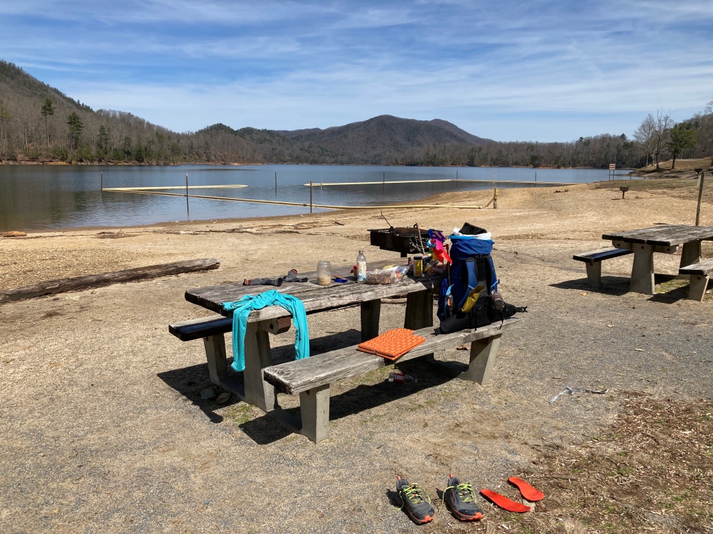
After the quick descent, I crossed a busy paved road, then tromped down a few steps to a deserted picnic area on the shore of Lake Watauga. I parked my stuff on a bench, flipped off my shoes and socks, and dove headfirst into lunch. While I waited for my oatmeal to soak, I pulled off my shirt, inspired by the hot sun to expose my pasty skin for the first time on this hike. The rays tingled delightfully. A light breeze reminded me of its warm caress.
I ate too much and didn’t drink enough. I could have stayed for the rest of the afternoon. Instead, after about one hour, I packed away my gooey Oreo’s, put on my shirt and shoes, and got hiking. The trail around Watauga was as pleasant as could be, flattish and scenic. After a couple of miles, I crossed the huge earthen dam, then climbed back into the hills.
I was hot and thirsty as the trail brought me back up, along the spine of a tremendous ridge. While scrutinizing my map, I noticed that the trail followed this spine, more or less straight, for almost 20 miles. It looked like a mistake. However, once I got going, I found that it was true. I bumped up and down as it undulated higher and higher, without more than a short switchback or slight waggle around a fallen tree or rock to disturb my bearing. The trail was steep in parts, but ample views through the trees back to the entire massif of the Roan Highlands, from the enchanted spruce forest on Unaka to the grassy bald of Hump, were there to ogle each time I needed to catch my breath.

I boosted to make up for my lake dilly dallying, needing to make it 10 miles in three and a half hours to reach a good water source in time to camp before sunset. I pushed hard and enjoyed the challenge. Lake Watauga extended forever down below, with endless marinas and picnic areas along its shoreline. Gunshots echoed from somewhere far away. Some snippets of Schoolhouse Rock classics echoed in my brain.

I found my campsite, complete with massive fire ring, just after the sun dipped below a distant ridge. I gathered water and flopped onto my pad, ready to eat and rest. More pb, noot, and hot sauce burritos tided me over until my couscous was finished soaking. I spooned it by red headlamp before I realized that the brilliant moon provided all the light that I needed. I lay back to sleep, an hour later than usual, but I think that this time change is something that I can get used to. I set my alarm for an hour later. An 8:30am start ain’t so bad.
On a day that started cold and ended hot, my favorite moment was the transition between the two. Even though the morning was sunny, a high veil of cloud sapped the sun of its power to warm. Shortly after leaving Laurel Fork Falls, the cloud departed, and the day heated up instantly. I felt it on so many levels. My mood improved, the world seemed happier. I removed my jacket, and with it, the micro-stress that movement was required to stay comfortable. I slowed down and enjoyed the easy strolling in a beautiful place. I kept that feeling for the rest of the day, even when I was pushing myself towards the end.
This post was originally published on my blog hikefordays.com. Check it out for trip reports from my other hikes including the CDT and Sierra High Route.

This website contains affiliate links, which means The Trek may receive a percentage of any product or service you purchase using the links in the articles or advertisements. The buyer pays the same price as they would otherwise, and your purchase helps to support The Trek's ongoing goal to serve you quality backpacking advice and information. Thanks for your support!
To learn more, please visit the About This Site page.

Comments 4
I love your posts! I read them every morning and wish I was out there.
I love hiking after snow, except when it warms up and the snow in the trees falls down. It seems to always fall and go down my back.
Love the posts and pics.
Good luck.
No day 27 yet?! Hope it went well. I’m following along with a planned start of my own on 3/10/24. I’m curious how many day’s cous cous you travel with and if you use a bear bag. It seems you eat then go to sleep a lot. Just curious. Safe travels.
Very astute, Jeff. I’m not sure why Day 27 got delayed. It was scheduled, but didn’t post. I just shook it loose now.
These days I divide miles to the next town by 25, that’s how many dinners, couscous and other, I bring with me for the section. One couscous portion for me is a box of Near East brand with the flavor packet. I think each is around 4oz.
And yes, I’m carrying an Ursack. I usually get up to pee last thing before I fall asleep and will usually tie my food to a tree then.
Hope that helps! I’m stoked for your hike, but I bet the wait is killing you.