Grayson Highlands: Steer, Wild Ponies, and a Detour
Heading Out Of Damascus In The Rain
I ended up taking two zero days in Damascus because moderate rain was forecast for Sunday and very heavy rain for Sunday night. Dig had received an invitation to spend the night with Kay, a local shuttler and trail angel. Lucky me. I was included in the invitation.
I spent Sunday afternoon talking with Dig and Kay. After a game of Scrabble, while Dig and I watched 60 Minutes, Kay prepared a delicious dinner. Thank you! The next morning, Kay shuttled us to Grassy Ridge Road, from where each of us had separately slack packed into Damascus, and we headed north in light rain.
Buzzard Rock And The 500 Mile Mark
The rain cleared before we reached Buzzard Rock on Whitetop Mountain, shown below. Two hikers pointed out that for those who hiked the Approach Trail to Springer Mountain, Buzzard Rock marks 500 miles. Whoopee!
In just over 8 miles ahead, we reached the official 500 mile marker on the AT.
Steer And Wild Ponies In The Fog
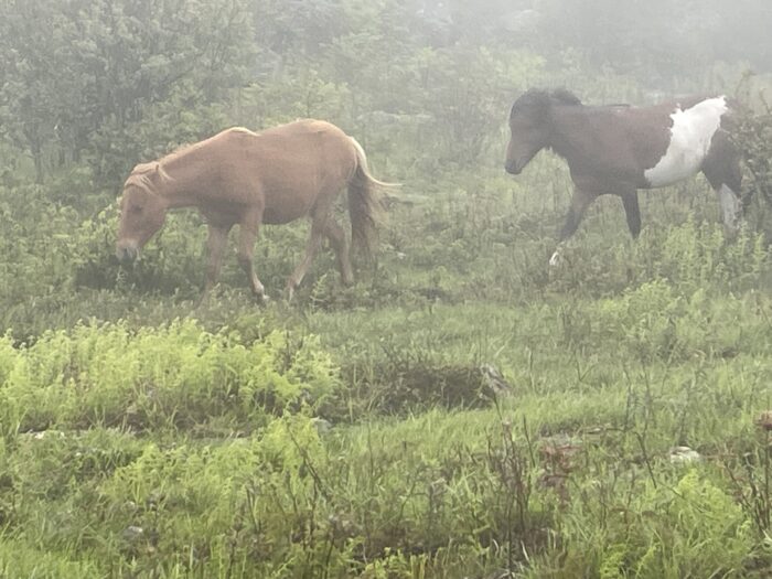
Grayson Highlands is known for its balds and meadows, offering vast views, and habitat for grazing steer and wild ponies. Unfortunately, we had hiked to the area in the rain the day before, it rained that night, and we woke up to dense fog. Despite these conditions, that morning, I was excited to hear a horse’s whinny when I retrieved my bear canister from the bear box.
Although there were no views, shortly before climbing through Fatmam’s Squeeze, a cavelike jumble of rocks, I saw several steer. I took photographs of 2 of them, but they are hard to see. Some distance later, I saw perhaps a dozen wild ponies, in pairs of 2, crossing the trail ahead of me. What a special sight! When the last pair passed, one of them whinnied. I wondered what that signaled to the herd.
Detour Due To Bridge Reconstruction
I later stopped at Wise Shelter to remove my rain gear and have a second morning snack. Dig and several other hikers were ahead of me.
At Wilson Creek there was a (short) trail detour due to a bridge reconstruction. Bright tape closed off the trail and a paper sign indicated that the AT was being routed to the right. After rock hopping across a near foot-soaking stream, I saw another paper sign with an arrow to a gravel road.
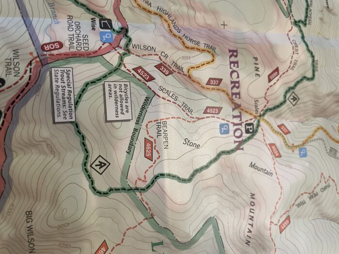
Unfortunately, I missed another paper sign nearby and continued up the gravel road, which I later learned is the Scales Trail, to a trail junction which has a sign indicating the AT was 1 mile away, on a trail I later learned is the Bearpen Trail. Most unfortunately, the Bearpen Trail was not marked and it disappeared at times.
The GPS on FarOut showed me I was generally headed parallel to and then toward the AT. But then it indicated I was on the AT, and I knew I was not. There was only a faint trail and no blazes. Then the trail split in 2 directions. Ugh. Lost in Grayson Highlands State Park.
Following the trail in one direction, it split again. Not a good sign. Following it in the other direction, I finally reached Bearpen Gap and then the AT. The map below (sorry it is sideways) shows I hiked a couple of miles out of my way.
I later saw a ridge runner who explained the the bridge reconstruction project was organized last minute. There hadn’t been any notification posted and there was inadequate signage. However, the project would be completed that afternoon, minimizing the risk that others would get lost.
Pizza Delivered to Mt. Rogers Ranger Station
I had no idea how far behind Dig I had gotten. We had planned to hike 16 miles to Hurricane Mountain Shelter. I was pleasantly surprised to find him stopped mid-afternoon at Old Orchard Shelter, only 11.1 miles down the trail. His feet were tired from the rocky terrain. I was tired from the turmoil of being off trail. So we camped there.
Suzu, who had been hiking with her Cousin Blue Brew, arrived after me. She, too, had taken a wrong turn, not at the detour, but onto one of the many trails in the park.
The next day, Suzu reunited with Blue Brew before Comer Falls. Dig had gotten ahead of me. On rocks just past the falls, I saw my first black salamander. I caught up with Dig at a trailhead where he was drying out his tent fly and eating lunch. I took out my tent to dry and also ate.
While we were sitting there, a couple from Florida, who had gone for a short hike, returned to their car. I asked if the would take our trash. We each had a small bag and I had an empty fuel canister. They agreed to take the trash.
I don’t know whether Dig was being sly or just talkative. He told the couple that at some trailheads, people provide trail magic. He even described foods offered. Next thing, the man offered Dig a Nutrageous candy bar, which we shared. Yummy.
Below Dig is hiking down a beautiful meadow. We planned to stay at a campsite and stream, 17.2 miles down the trail. At the campsite, we met Slurpy and Burpy. The next day, we all enjoyed pizza and salad delivered to us from Perfect Pizza at the Mt. Rogers Ranger Station.
Dig’s Fire-Building Skills
Last night, Dig and I stayed at a campsite, which was just over 3 miles to our destination—the Relax Inn in Groseclose, VA. Dig was picking up a resupply box and I was picking up a new Zpacks duplex tent. The Zpacks tent I have been using is 6 years old (see below), and I did not think it would last the entire trip. I decided to replace it before it failed on me.
With a nero day ahead of us, Dig had the energy after hiking 15.2 miles, to build a fire. You have to understand that Dig is a master fire builder. In his youth, he attained the rank of “little chief” at summer camp by demonstrating his ability to light a fire with only 2 matches and no paper.
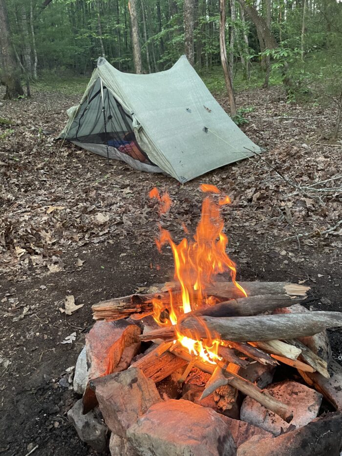
Once before while I was on the trail with Dig, he built a fire. I regretted that I had not photographed the process. This time, I did. First he collected what he called “squaw wood” (I don’t know if the term has been renamed), which are dead branches on living rhododendron or mountain laurel trees. Then he raked out the soggy ashes in the fire pit and lined it with flat rocks.
He placed 2 medium-sized logs in a V. Through the opening, he would later insert a lighter. Building a square frame, he piled small sticks on top, then kindling, then larger sticks. After he weaved in several layers of firewood, allowing for air flow, he inserted the lighter in the opening of the V and lit the wood until it caught. After a few minutes of smoky flame, the smokeless fire below blazed.
I have had a relaxing day. Rested, packed, and refreshed, I look forward to an early start tomorrow.
This website contains affiliate links, which means The Trek may receive a percentage of any product or service you purchase using the links in the articles or advertisements. The buyer pays the same price as they would otherwise, and your purchase helps to support The Trek's ongoing goal to serve you quality backpacking advice and information. Thanks for your support!
To learn more, please visit the About This Site page.


Comments 8
I like the pace you’re going, it’s seems relaxing and you’re enjoying the hike! Glad you got to see the ponies!😍
Thanks! Have to listen to the body!
I really enjoy your attitude. I also like the pace you are walking. Thank you for sharing your experience!
Thanks!
brave green mtn girl hikes up and down mountains in all kinds of weather
all of us back home in green mtns cheering her on…many blessings
Thanks Dovid! I appreciate your blessings.
Phyllis I am enjoying reading about this amazing hiking you are doing. Seth has been sharing with me . I just signed up myself.
So glad you are following my adventures!