 ">
">
Hiker Sprains Their Ankle in the White Mountains
Bama➡️Baxter Day 151&152
Day 151: 20 miles
This morning all of us woke up nice and early to, hey, going on the presidential traverse! We had to do about 20 miles in order to get up and over the traverse because of camping restrictions. We knew there would be a whole lot of tough terrain and elevation gain, so we were up around 5:00 a.m. and walking around 6:00 a.m.

Views as we climbed Webster cliffs this morning at the start of the presidential traverse.
The morning started out with a pretty long climb the rest of the way up the Webster cliffs. We got some fantastic exposed views as the morning went on. It was a really beautiful way to start off the day and the weather was fantastic. Not long into the morning, we got to the summit of Mount Jackson, which was a nice climb. There was a lot of technical climbing, which required your hands for miles on end. And as we continued along, the trail leveled out a bit upon approaching the Mizpah Hut. We decided to take our first break of the morning at the hut around 8:45 a.m. I ate something, drank a bit of water, then I did my stretching. We were making pretty decent time, considering the rocky scrambles and technical terrain.

Sweet Pea climbing a particularly rocky portion of the trail up Webster cliffs.

Views from the top of Mount Jackson.
From there we continued along and did another handful of miles. There was a lot more elevation gain but we managed just fine. Then, once we were about 1.5 miles from the Mount Washington summit, we passed by the Lakes of the Clouds Hut. We couldn’t resist stopping off to take a break and see about getting something to eat. The guy working inside was really nice and made us all bowls of soup. He even spiced them up a bit because he had said the soup was a little bit bland previously.

A lake right by the lake of the clouds hut.
We didn’t stay at the hut for too long because we wanted to get up on top of Mount Washington. Sweet Pea’s parents were coming to meet us at Mount Washington, so we didn’t want to make them wait too long. Those last 1.5 miles had a ton of elevation gain and were pretty tough. But I carried on just fine and didn’t really have to rest at all on my climb up to the top.
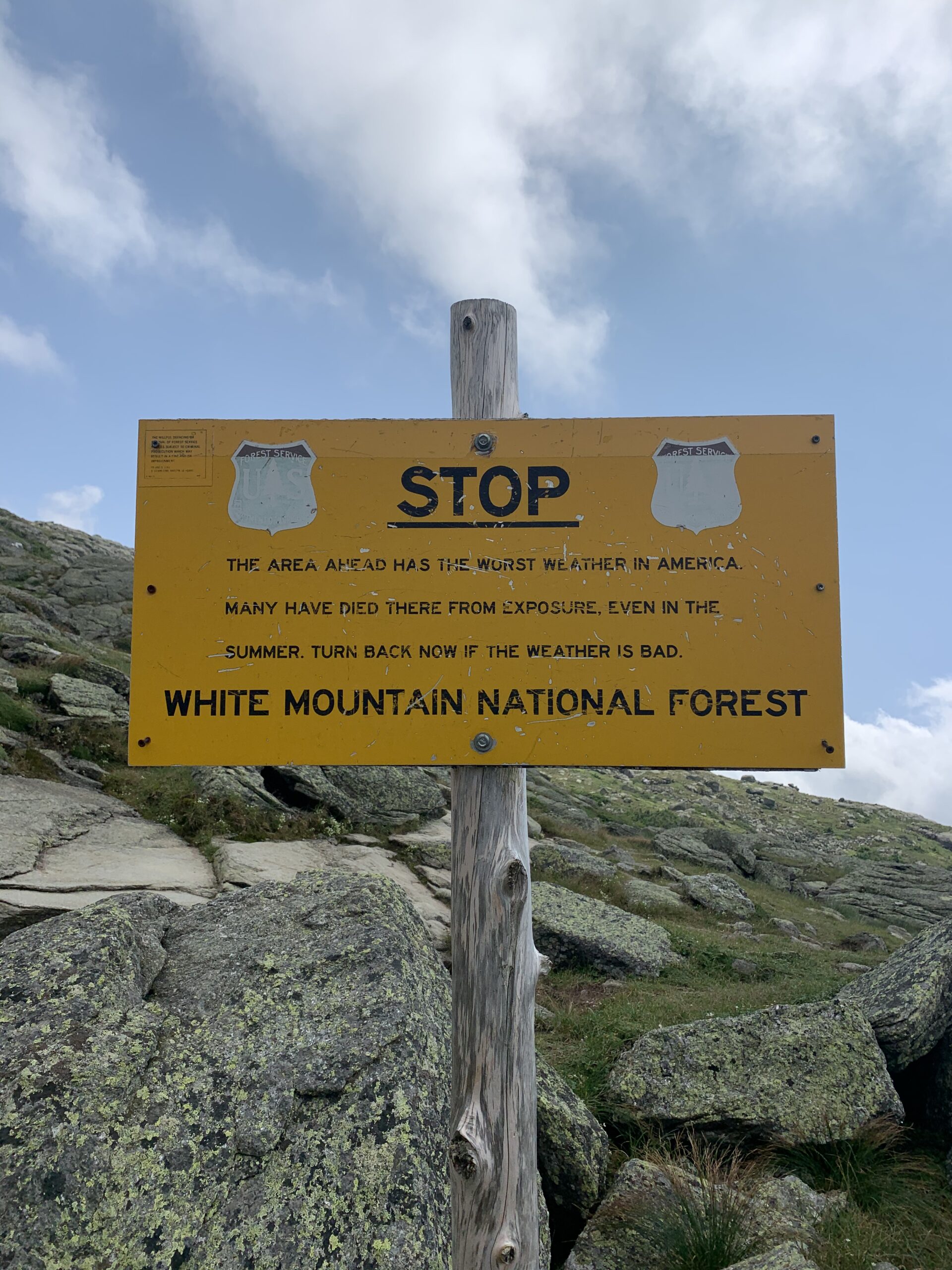
The warning sign letting hikers know that the ascent up to Mount Washington can be deadly depending on weather conditions.
It felt good to fly by day hikers on my way up. One group of guys that I passed were complaining to me about how hard the climb was. They asked if I was also having a tough time, to which I responded that it’s definitely a bit easier if you’ve been hiking since Alabama! The climbing is tough no matter what, but it’s definitely a lot easier after you’ve been climbing mountains every single day for the last five months just about.
When we got up to the top of Mount Washington, I was caught off guard to see the long line to get your photo taken in front of the sign. Nearly everyone there had driven up or taken the train up and yet was still eager to get their photos taken at the top. It was crazy having to wait in line behind 15 people to get your photos taken atop a mountain that you just climbed for hours. Plus, the views by the sign at Mount Washington were obstructed by loads of construction, which felt a bit ironic for a mountain photo op. But I was grateful to be up at the top still.

Posing with the Mount Washington sign! Which is basically a construction zone at this point.
Sweet Pea’s parents met us while we were up there and brought a bunch of snacks and drinks for all of us. That was so incredibly nice of them. It was nice not to have to deal with the store on top of Mount Washington. And instead we were able to sit at a picnic bench away from everyone and do our own thing. I was pretty darn happy about that.
After sitting up top for a while and taking a nice long break, eventually Sweet Pea’s parents had to head out. Then the three of us had to get back to hiking. We still had a very long day of walking ahead of us to complete the presidential traverse. You aren’t able to camp along the traverse, so we must get to the boundary before were able to camp for the night.

The descent down Mount Washington.
The descent down Mount Washington was surprisingly gradual. I was grateful that it wasn’t too intense and didn’t hurt my knees too much. My knees have definitely been sore on the terrain here in the Whites. On our way down, we may or may not have mooned the train… but who could say for sure.

The train tracks that go all the way up to Mount Washington.
The views that we got on the way down from Mount Washington were fantastic. Easily some of the best of the day. Those next few miles were some of my favorites and the time went by very quickly. Though the terrain was pretty rocky, and I wound up rolling my ankle not once, but twice. And I fell into a bush. But that’s just life out here. Luckily my ankle didn’t hurt too bad after I rolled it, so it seemed like I was in the clear.

Beautiful views as we descended Mount Washington.

Incredible views along the descent down Mount Washington.
After a long descent, we made it to the next hut along the trail. There, we took a nice long break, and I made a sandwich for myself. Everyone inside the hut was getting ready for dinner, but of course we weren’t able to get in on that. We were there for a while and then made the ascent up Mount Madison.

The Madison spring hut where we took a quick break before climbing Mount Madison.

A photo of me at the top of Mt Madison.
The climb was incredibly rocky and technical but was very fun. It was a rocky scramble using your hands for the entire mile up. It’s cool how much the terrain has changed in the last five or ten miles. Madison was literally just a big pile of rocks, unlike many of the other mountains we’ve climbed so far in the Whites.

Sweet Pea on top of Mount Madison.
From there we began a long and nightmarish descent down Madison. It was a never-ending boulder field all the way down, which seemed to go on for miles and miles. The rocks were incredibly sharp, much more than they have been recently. So I had to go nice and slow because I was worried that if I fell, I would get seriously hurt. It took me ages to make my way down off the mountain, and treeline was nowhere in sight.

Views along the descent of Mount Madison.
Little by little I made my way down off of Madison. The positions I had to go in to climb from rock to rock left my knees hurting and my ankle incredibly sore. I didn’t think I hurt it that bad rolling it earlier, but because of the technical terrain coming down Madison, I really started to irritate it. By the time that we hit treeline, my ankle was killing me, and I was exhausted. And we still had miles to go to get to our campsite for the night.

Turning around to capture photos of Mount Madison as we began to descent. It was such a long descent!
I figured that once we hit treeline, the terrain would level out and become a bit more easy. But instead we hit the treeline and had 2,000+ feet of elevation loss over the next two miles. It was pretty intense. My ankle was really starting to hurt at this point, and after a mile it was in sharp pain with nearly every single step. We’re not out of the Whites yet and there’s a lot more technical climbing to do in the days to come. This is not the time for an injury.
The miles were taking forever because of how incredibly steep the trail was. And by the time that I reached the junction for the first campsite past the presidential traverse, it was starting to get dark. Sweet Pea was sitting there drinking some water and I told him about my ankle. I was pretty damn worried at this point. We had planned to do a couple more miles, but I knew that if I walked much further, I was going to be in a world of pain. The last mile was excruciating.
There I filtered water, took some ibuprofen, and rested for a little while. Boosted wasn’t that far behind us and I explained to him how much I was hurting. The guys had no problem with the idea of only doing another mile or so at most. We got water so we could pretty much stop and camp at the soonest tent site that we found. We just didn’t want to stay at the designated site because of how busy it was going to be.
After we all got water, we continued along. I was really hoping that we found something soon. Though the ibuprofen definitely started to help my ankle almost immediately. I was very grateful for that. I knew that if the pain had kept up at the level that it was during the previous mile that it was going to be hard to continue on. Unfortunately, we did have to do about one more mile before we found a place to tent. But we did find a pretty nice place where all of us were able to fit our tents.
I got set up for the night and then laid in my tent. All I wanted to do was rest at this point.
The guys made dinner and sat out for a while. I did my stretching, rested, and talked with the guys for a bit before calling it a night. All I can hope is that waking up in the morning I feel a whole lot better. I plan to set alarms for the night so that I can take the maximum dose of ibuprofen to help get the inflammation of my ankle under control. Though today wouldn’t have been that bad of a day if it wasn’t for my rolled ankle. The 20 miles on the presidential traverse came pretty easily up until I had major ankle pain.
Day 152: 12 miles
This morning I woke up and it felt like my ankle was a little bit better than yesterday. I was just happy that it didn’t seem incredibly sore and hadn’t tightened up overnight. Last night it poured rain, but my setup stayed completely dry. I was grateful for that.
The guys and I packed up fairly late in the morning and then got moving around 9:30 a.m. When I first got out of my tent, I was pleasantly surprised that my ankle wasn’t too sore. As long as it doesn’t get much worse over the course of the day, I think I’ll be all right. The terrain when we started our day was pretty gradual with a bit of downhill and flat walking. I was very happy about that.
We had to go for about four or five miles until we came to a trailhead where we planned to take our first break. Last night I was thinking that in the worst-case scenario I may have to hitch out from this trailhead and take the day off to rest my ankle. But over the course of the miles this morning, I was surprised that I no longer thought that was going to have to happen. I was able to walk cautiously and keep the pain away.
When we got to the Pinkham Notch trailhead, I realized I’d actually been there before. Back in 2017 my friend Patricio and I came to this trailhead to climb Mount Washington. That was shortly before I went out west to hike the Pacific Crest Trail for the first time. It really brought me back to be there in the parking lot once again. The last time I was here, I was such an inexperienced hiker and backpacker. I’m such a different hiker now only six years later.

Pinkham notch visitor center.
At the trailhead, we all took a nice long break by a picnic table. There was a small store in the building by the parking lot where we are able to get sandwiches and drinks. I got a couple snacks to top off my resupply, a sandwich, and a soda. Then I joined the guys outside and we drank and relaxed for a while. It felt good to rest my ankle, but it definitely wasn’t bothering me nearly as much as it was last night.

Hanging out taking a break at the Pinkham notch visitor center.
After a while, we left the trailhead and got back to walking. Then we began the ascent of the Wildcats. A pretty infamous climb. And it was definitely no joke. Not long into the ascent, we were doing some pretty intense and technical climbing. There were a couple of areas where you had to hoist yourself up about four or five feet to get up and over steep, flat rock. It was slow going for sure. But at least the boulder scrambles seem to tire me out a little bit less than traditional steep elevation gain typically does.

Wooden steps which you have to climb up to ascend the Wildcats.
About two miles into the climb, I stopped off to grab some water. Then I continued along to get to the top of the climb of Wildcat. Up near the top, there was a chairlift for skiing and snowboarding. Boosted and Sweet Pea were hanging out there waiting for me when I arrived. It made for a very cool place to stop and take a break before doing the small amount of remaining ascent up Wildcat.

The ski lift up top of the wildcats.
After our break, we had a bit more climbing. Then we began a brief descent before yet another climb. Though I wound up talking to another hiker, Slim Pickins, on the next climb, which definitely made it go by a lot faster. We ran into him a while back, way before Trail Days! It was wild to run into him once again so late in the trail.
Once we got to the top that last climb, we had a fairly long descent from there. It was quite steep but wound up being pretty perfect. I was able to lower myself down nice and slow and take my time. My ankle actually felt really good. I was so happy about that after being so genuinely worried about it earlier in the day and last night.

A lake that we passed by the hut past the wildcats.
About ten miles into the day, we arrived at yet another hut. We decided to hang out there for a while and take a nice long break. Then we continued on to do another climb, which went on for a mile and a half. But by god did it feel so much longer. It was super steep to start but then wound up leveling off nicely. Unlike the more recent boulder scrambles that we’ve been doing, the climb was a more of a hike. I was able to actually make good time, which felt amazing.
Up at the top, the guys were hanging out. It was around 6:30 p.m., so we began to talk about how much further we wanted to go today. We figured that the earlier that we stopped for the day, the earlier we could start walking tomorrow morning. So we decided to just walk for another half mile or so until we found a place to tent. Because we were at pretty high elevation, there were no bugs, which was great. But we were still within treeline, so the site was protected from the wind.

The beautiful trail weaving along near our campsite for the night.
I got my tent set up and then sat out with the guys to cook dinner. First I made some ramen and then a hot chocolate. Then I was getting comfortable in my tent by 8:00 p.m.! It felt great to have an early night.
Plus, tomorrow we only have to do 13 miles to get to the town of Gorham, which marks the end of the White Mountains! We still have a couple more peaks to bag tomorrow, but then it’s pretty much all downhill to town. Hopefully we’ll make good time and get to spend most of the day relaxing in town. And I’m so happy to say that my ankle is feeling great at the end of the day today. I can’t believe how concerned I was last night. I’m genuinely surprised that I felt so much better this morning and was able to hike all day without pain. The trail really does provide!

A lovely lake right by one of the huts.

This website contains affiliate links, which means The Trek may receive a percentage of any product or service you purchase using the links in the articles or advertisements. The buyer pays the same price as they would otherwise, and your purchase helps to support The Trek's ongoing goal to serve you quality backpacking advice and information. Thanks for your support!
To learn more, please visit the About This Site page.

Comments 9
Glad to read that you really didn’t sprain your ankle, especially in that terrain.
You go girl (woman).
I’ve hiked in a day, and have hiked it in three days.
I’d Trail Magic’d a hut stay or two. Even Joe Dodge.
You are coming up on Maine, and Gorman Lodge is worth a stop, not far off the AT. I don’t know about the dog though.
Send me an ETA and I’ll try to arrange some bunks.
Then you can finish Katadin strong.
My son and I have walked the Whites 3x from age 6 to 12. He’s 29 now. I’m 70.
Enjoyed reading about your struggles with a sore ankle. Impressed with your mental toughness in dealing with that. I teach primitive survival skills at my farm in NH not far from the AT that runs up Moosilauke and come in contact with a lot of Thru Hikers.
Hope to hear more about your adventures!
Enjoy reading about your adventure,I’m a middle aged man that used to hike a lot not so much anymore.Did multiple section hikes on the AT and the pct and the Florida trail which is in my backyard.Looking to getting back in to hiking have bought most of my gear but have done more MTB touring lately.Your post ended up in my morning news feed on my phone ,glad I stumbled across your page ,your a true inspiration to me getting back out in the woods.Be safe out there and again i really enjoy the content.Keep up with the mushrooms they will do wonders for you,took my depression completely away!
I’ve sprained my ankles at least a dozen times in the WMNF. The terrain is no joke and by far the toughest on trail. YOU GO GIRL!!
Peg,
Glad to hear your ankle roll was not more serious. I am enjoying your blogging and living vicariously in your AT adventure.
Keep on trucking
Alex
Peg,
Just did that same section earlier this month. Great summary of the terrain! Madison! Wow. Brutal. We arrived at Pinkham Notch at around 10 pm! Family was waiting on us. Prayers for you!
Aragorn
I hiked Mount Madison for the first time about a month ago and can totally relate to your trail descriptions! Definitely a challenging hike. I loved reading your blog and wish you the best on the rest of your trip!
It seems that the more photos people take of cairns the more they think it’s okay to build them.