 ">
">
Penn’s Woods, or, a test of strength
I’m now two-thirds of the way through Pennsylvania, and honestly? It’s been tougher than I expected. Not because of the rocks, though that’s been part of it, but because of the distances involved. The PA section of trail is over 200 miles long, and all of it’s roughly halfway to Katahdin. That’s 229 miles to feel like you’re walking from somewhere very far away to somewhere else very far away, without much going on to mark your progress. I suspect this feeling’s what’s really behind the legend of ‘Rocksylvania.’
There are a lot of different opinions about Rocksylvania. Some say the rocks start at Duncannon; some say at Lehigh Gap. Some say the section before Lehigh Gap has the worst rocks. Most, but not all, concur that the first sixty miles aren’t too rocky. This is why I think Rocksylvania is more of a state of mind, a feeling that creeps up on thru-hikers halfway through, than a truly objectively rocky stretch of trail.
1. Going for a Thirty
The day after my double zero in Frederick, I packed up early from the Dahlgren campground and started walking. Since I wasn’t doing the punishing ‘Maryland Challenge,’ I thought I’d at least try for a thirty-mile day on my way out of the state. I also knew that Pantless and Goodall were doing the 44-mile ‘Four-State Challenge’ that day, and I didn’t want them to get ahead of me just yet.

The ‘original’ Washington Monument, as we like to say. Not quite as awe-inspiring, but still a monument.
I paused at the jug-shaped Washington Monument for breakfast, looking out from the top of the tower over Boonsboro. Then I crossed Interstate 70 and continued up the trail towards Annapolis Rocks. This was all familiar ground to me, and my only surprise was how quickly I was covering it.
As the day went on, I started messaging Pantless to see when we’d cross paths. First they were nine miles away, then four, then only two. By the time I arrived at Pen-Mar at the PA border, we were nearly in the same place. I’d ordered a pizza delivery to the trail, and was just finishing eating and getting ready to head out when I saw a familiar face. It was Bididit, who I hadn’t seen since Tennessee. Turns out they’d joined up with Goodall and Pantless in their new trail family ‘The Amoeba,’ and the rest of them soon started trickling in. It was great to see so many friendly faces, and to catch up again after 600 miles of trail. A bunch of people I’d met south of Virginia had banded together, and they were now the largest tramily in this part of the bubble.
I couldn’t stay for long, since it was getting late and I still had seven miles to go. I found out I’d end up ahead of them again, since they were taking a few neros and zeros to rest up from their long day. So I said my goodbyes and plodded on into the evening.
Before I reached the shelter I was aiming for, night set in and it started to rain. So when I saw a picnic shelter nearby around ten pm, I settled in and set up my tent between two tables. It was an awkward way to camp, but it kept me dry. I’d done my thirty miles, but it had taken way too long. I decided I wouldn’t push for this far in a day again, unless I was out before sunrise and had a ton of energy that day. Setting up camp in the dark is just no fun.
2. Halfway Points
The next day I traveled on through Michaux State Forest, the lush rolling hills that form the northern frontier of the Blue Ridge. In the morning I walked a few hours with ‘Recyclops,’ the first hiker I’d met who’d started in April. She wouldn’t be the last, either — since I entered PA there’s been a steady trickle of speed-hikers passing by, some doing more than 30 miles every day. I knew they’d catch up eventually, but it still feels strange. I’d gotten to thinking I was a pretty fast walker, and everyone in my bubble thinks mid-20s is reasonable mileage for one day. But then you run into people talking about slowing down to the high 20s for ‘Rocksylvania’ and, well, it puts things in perspective. It also makes me think of the main bubble two weeks behind us, valiantly pressing on at 15 or 17 miles a day. The people around you shape your expectations, and, on the trail, who’s around who is determined mostly by speed.

Halfway there!!
At the end of that day I reached this year’s midpoint of the trail, in a peaceful little valley where two small brooks join. In an ill-omened twist of fate, this valley is called ‘Dead Woman Hollow’ and was home to a secret POW camp during World War II. None of that’s evident from the trail, though, and it was a beautiful place to reflect on how far I’d come and take that symbolic step over the thin stream of water separating the southern and northern halves of the trail. 1097.15 miles down, 1097.15 miles to go.
I stealth camped for the night on an open heath, where the mountain’s been cleared by fire to create a savanna of blueberry bushes studded with pitch pine and sassafras. It was beautiful, but buggy. I found my first tick that day, and my first mosquito. The flies swarmed around my head trying to bite, and I actually regretted the end of winter. Warm weather comes with challenges of its own.

Midpoint sign number 2, with different mileage. Nobody said this wouldn’t be confusing!
The most memorable thing about this part of the trail is the multitude of midpoint markers. Two miles past the 2022 midpoint is the ‘official unofficial halfway point’, a permanent signpost with flags and arrows in all directions that was put up ten years back. Then comes Pine Grove Furnace at mile 1105, a former midpoint and still the nearest landmark to the halfway point of the trail. And then finally, at Center Point Knob (mile 1121), a venerable plaque marking the original midpoint of the trail. It’s enough to give you halfway-point fatigue.
The previous day, I’d noticed a seam in my shoe start to come undone, and the stitch unraveled more with every mile. Worried, I called my partner to ask for help, and she offered to come up with some repair supplies and meet me at Pine Grove Furnace. (It’s nice to be within driving distance of friends and family for a few weeks!) So we ended up hanging out for a while at the Pine Grove Furnace store, eating and chatting and fixing my shoes. Sewing the seam and sealing it with shoe glue seems to have worked (thank you Andrea!!!!) and I should get a few extra miles out of my shoes.

Ready to head out in the rain from Pine Grove Furnace.
Time Lord, someone else I hadn’t seen for hundreds of miles, also caught up with me in Michaux. Andrea met her at the Pine Grove Furnace store, and gave her a ride to Duncannon after I left. Back in Tennessee, Time Lord had a very large and social trail family, which seems to have dwindled away through Virginia. It’s so strange how these groups ebb and flow!
Before I kept walking, we went through the Appalachian Trail Museum, in an old stone house just across from the store. I love this place — it’s full of AT artifacts and memorabilia, and really preserves the history and spirit of the trail. They have gear used by Earl Shaffer, Grandma Gatewood, and Gene Espy; a reconstruction of Benton MacKaye’s study; and one of the original lean-to shelters salvaged from along the trail. They also have wonderful exhibits introducing casual visitors to hiker culture — I actually learned something from these the first time I stopped by — and a research library on all things AT that’s open by appointment. I’d highly recommend a visit if you’re nearby.
3. Boiling in the Valley
The day after my stop at Pine Grove Furnace, I started down the last few slopes of the Blue Ridge. For those who might not know, the Blue Ridge mountains are an enormous range, stretching south into Georgia all the way past Springer Mountain. Most of the southern trail goes through them, except for that long detour into the heart of southern Virginia. In Penmsylvania, though, the Blue Ridge kind of collapses into the ground, undulating through smaller and smaller hills down into nothing. And the Appalachian Trail follows it almost to its very end before turning north across the Cumberland Valley.

The boulders of Rocky Ridge.
There’s something poetic about the walk down this failing mountain chain, like you’re traveling on the back of a dragon that’s plunging into the ground. I especially feel this in a two-mile section called Rocky Ridge, where the trail winds through a sharp, steep spine of boulders barely a thousand feet high. Then comes Center Point Knob, the final descent into farmland, and the town of Boiling Springs.
Boiling Springs is a little gem of a town, one long street of Victorian homes facing a well-kept park. A lake, flowing from the namesake ‘boiling springs’, meanders through it, and empties into Yellow Breeches Creek south of town. The day was hot and humid, so the creek was my first stop. I jumped in for a cooling swim as soon as I had the chance, and chatted with two local fishermen who just weren’t catching any trout. Then I walked across town to the post office, where I sent home my rain pants (they’re no use when it’s over 60 degrees), and settled in on the cafe patio for a delicious lunch.

Yellow Breeches Creek on a hot May day.
The rest of that day was my first real test of hiking in the heat. The fourteen-mile Cumberland Valley crossing has no water or shelter, and the temperature was climbing above 90 degrees. I took off my shirt and slathered myself in sunscreen and bug spray before striking out through the farm fields. I was able to keep up a steady pace but was soon dripping with sweat. After a few miles I soaked a bandanna in water and wrapped it around my head to stay cool. Towards mid-afternoon, I was incredibly grateful to find a little Amish farm stand selling chocolate milk. I cooled down by drinking two whole pints before moving on. Meanwhile, the mosquitoes were biting, and I kept a constant eye out for ticks as I went through the tall grass.

Chocolate milk!
Needless to say, I was exhausted by the time I made it to the mountain on the other side. A small stream ran next to the trail, and I lay in it to cool down, turning from my back onto my stomach so I could drench my whole body in the shallow water. (This might seem like an odd thing to do, but it was a very hot day.) I stopped on the ridgetop, near the Darlington shelter, and set up camp there for the night.
4. A Purgatory of Ridgetops
The next morning was tough going. I was tired from the previous day, and though I knew that town — a little place called Duncannon on the Susquehanna River — was just a few miles away, it seemed to take forever to get there. It didn’t help that the last time I’d hiked this section of trail, I’d done it overnight. I have a dim memory of my headlamp shining over dark rocks, with shadowy trees overhead and a sense of the mountain falling away on either side. In the daylight, it was just a jumble of rocks stretching out before me, and the knowledge that I still had at least five miles to go.
At long last, I found myself at Hawk Rock, looking out at the Juniata and Susquehanna Rivers as they converged north of Duncannon. I climbed down the hill and walked on into town.

Looking down to Duncannon from Hawk Rock.
The last time I’d visited Duncannon, it had bean a Sunday. As it is a small and traditional-minded sort of place, almost everything had been closed. So I’d walked on through the empty streets and ordered a pizza at the one place that was open.
Guess what day of the week it was when I went through Duncannon this time?
It was a Sunday.
I first went to the hostel/outfitter to pick up my resupply box, took a shower, and washed my clothes at the laundromat nearby. I ordered my pizza at the one place that’s open on Sundays. As I was getting ready to leave, it started pouring rain outside, so I hung out for an hour or two until the outfitter closed at four. I didn’t trust sleeping in a bunk because of the COVID surge, and there was nowhere else to stay in town, so I decided to push four miles ahead to the next shelter.
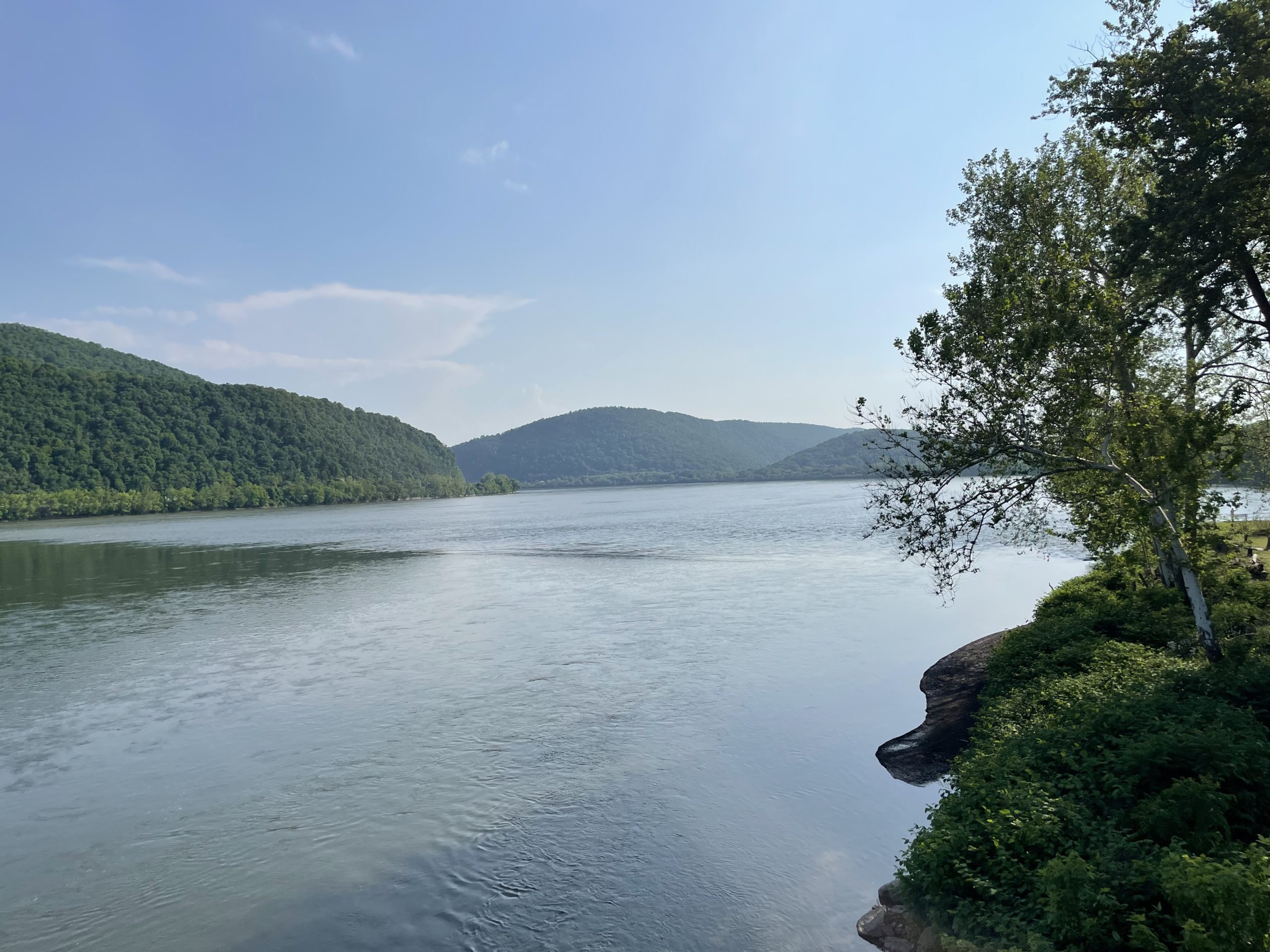
Crossing the Susquehanna.
So it was that in the late afternoon, I crossed the Juniata and Susquehanna rivers, on huge concrete bridges with traffic roaring by. The Susquehanna River is half a mile wide, surging like a moving sea down towards the bay. Everything near the river has a fresh, watery smell, like mud after a summer rain, and a blue haze hangs in the air. You can even smell the river up on Peters Mountain, until it winds away to the north and south.
The first few miles of Peters Mountain are a jagged scramble along cliffs, and I was exhausted again by the time I arrived at camp. The heat and fatigue must have tired me more than I knew, because as I tried to throw my bear hang the rock bag caught on a hazel branch and flew straight into my face. So now I have a self-inflicted bruise below my eye, but no bears have taken my food. You win some, you lose some, I guess?

At Swatara Gap with my self-inflicted bruise.
Peters Mountain is a dry ridge, and the next morning was a long monotonous hike carrying too much water. Towards midday I descended into a valley, and entered ‘St Anthony’s Wilderness’ on Stony Mountain. This is an old coal-mining area where I’ve spent some time before. My spirits picked up as the trail improved and I started to recognize where I was, even if half the springs were caked orange with toxic leaching from the mines. I stopped early for the day at the Yellow Springs Campsite, the ruins of an old village that’s stood empty for a hundred years.
5. A Blue Mountain Welcome
I’ve described the 370 miles from Big Meadows to Delaware Water Gap as my ‘home stretch,’ and in the sense that I’ve walked it all before that is true. But some stretches are closer to home than others. The Maryland trail, from Harpers Ferry to Pen Mar, is intimately near home, and brings back memories of hiking as a kid. The next section north, from the PA border to Peters Mountain, I encountered for the first time just last year, and only once. From Yellow Springs onward, I’m in a different kind of ‘home stretch’ — the section of trail I know from a decade of excursions out of Philadelphia, in piecemeal segments I connected together through section hikes later on.
The common thread that stitches this Eastern Pennsylvania trail together is Blue Mountain, or Kittatinny (kitahtëne), a name that means ‘big mountain’ in Lenape. This is often rendered in English as ‘Endless Mountains,’ but of course the mountain is not endless: it ends near the Maryland border to the southwest and in New York’s Shawangunks to the northeast. Nevertheless, for hundreds of miles it stands as a rugged wall above the Great Valley, separating the wooded hills to the north from the fields and meadows to the south. It is very big, and yes, it is very rocky.

Standing at the ‘501 lookout’, one of the better overlooks on Blue Mountain.
As soon as I crossed Swatara Gap and climbed Blue Mountain, I felt a little more at home. I may have been on an endless rocky ridge, but the ‘purgatory of ridgetops’ I mentioned earlier was over. Slowly but surely, the landscape was coming together into a frame of reference I knew, instead of being a middle ground between one place and another. And I started hitting new milestones: 1000 miles to Katahdin, 55% done, entering the Delaware watershed. It almost didn’t matter that every few miles I had to cross a boulder field. I was headed to places I knew, and I was going North. The stands of black birch are welcoming me to a land that is decidedly not Virginia.

Some people don’t mind the rocky trail! This little rock made my day.
Also, for the first time in a while, I had a destination. I’d made a booking at the Microtel in Hamburg, two miles off the trail, and would take a rest day there. So last night, I camped on the ridge just a mile from Schuylkill Gap, and descended into the valley before breakfast. I walked through Port Clinton without stopping, past a bridge scrawled with the paranoid ramblings of its resident schizophrenic, and down a mile of highway past cars speeding into coal country. I stopped for breakfast at a Wawa — an actual Wawa! — and chatted with some locals there who were interested in my hike.
Now I’m in a coffee shop in downtown Hamburg, waiting out the morning with a bottomless cup of coffee. Reading’s just down the road, and I can almost imagine New Jersey over the horizon. I may have a rocky 70 miles to go, but I have a feeling that maybe — just maybe — my personal Rocksylvania’s a thing of the past.

This website contains affiliate links, which means The Trek may receive a percentage of any product or service you purchase using the links in the articles or advertisements. The buyer pays the same price as they would otherwise, and your purchase helps to support The Trek's ongoing goal to serve you quality backpacking advice and information. Thanks for your support!
To learn more, please visit the About This Site page.

Comments 3
“That’s 229 miles to feel like you’re walking from somewhere very far away to somewhere else very far away, without much going on to mark your progress.”
Don’t have this perception. That feeling in effect is lying to you. You just listed five things that marked your progress. Those are the over-riding feelings/experiences to have. In effect you have overcome ” without much going on to mark your progress.”
Stay close at hand, in the moment, in the day, in the week. Walking with daily and momentary gratitude can be the vehicle.
Fun read, you’re officially a great hiker in my mind. I think you might just do this, we’ll see. choc milk from an Amish boy what a treat. I’ll be reading with
increasing anticipation as you approach my familiar trail section. CT Mass border. Thanks young man
This is awesome I love reading this. I almost fell off the.couch laughing when you mentioned the Microtel. I grew up in Pottsville so hamburg is very close. I live in HBG now so of course Peter’s mnt is the closest AT(thanks for not mentioning how much litter and graffiti are up there). Keep fine and be safe!! Best wishes!@