 ">
">
Reflecting on My AT Thru Hike, Part I: Rutland, VT to Katahdin, ME
(Disclaimer: this post was written well after completing the AT)
Hi everyone. I completed my hike of the Appalachian Trail on September 12th. It took me a long time to feel ready to process the completion of my hike; I apologize for the long wait. This is the first of two posts on finishing the AT and how it’s affected me. This portion is a trail update on my final section.
Hiking into New Hampshire changed my perspective… and tested my navigation skills
I have so many emotions thinking back on this portion of my hike. It was in this section that my tramily really solidified, the views started to become stunningly beautiful, and I started to contemplate that I was nearing the end of this journey. Up to this post, I also had extensive notes from my trail journal to reference for my writing here. I stopped making new entries in Pennsylvania, shortly before Delaware Water Gap. I think it was a mix of my mindset at the time (negative) and the fact that everything I’d been experiencing felt so routine to me. I’ve spoken about this in some of my earlier posts, and unfortunately, I think this feeling of routine just continued to amplify as I continued to hike towards Katahdin. Sure, there were sections with novel views and towns with quaint restaurants and hostels, but I’ve been on trail so long at this point that even the novelty of novelty has worn off.
Looking back, I’m a bit sad that I decided to stop writing journal entries–so much happens in a day that even the things I wrote down don’t convey all of the notable experiences. So without entries, I know I’ll forget a majority of my time from this point forward. At the same time, I think acceptance of routine is a sort of necessity on trail. I’ll stress this again–living on the trail feels like just that–living. Hiking the AT is a way of life. I think this adaptation is common–maybe even necessary–among those who complete a full thru-hike. Personally, I think the emotions that an experience leaves you with are more important than any particular memory. And so far, this experience has been so positive that I think I’ll end up doing another long walk. A common saying is “a bad day on trail is still better than a good day at work” and this rings true to me.
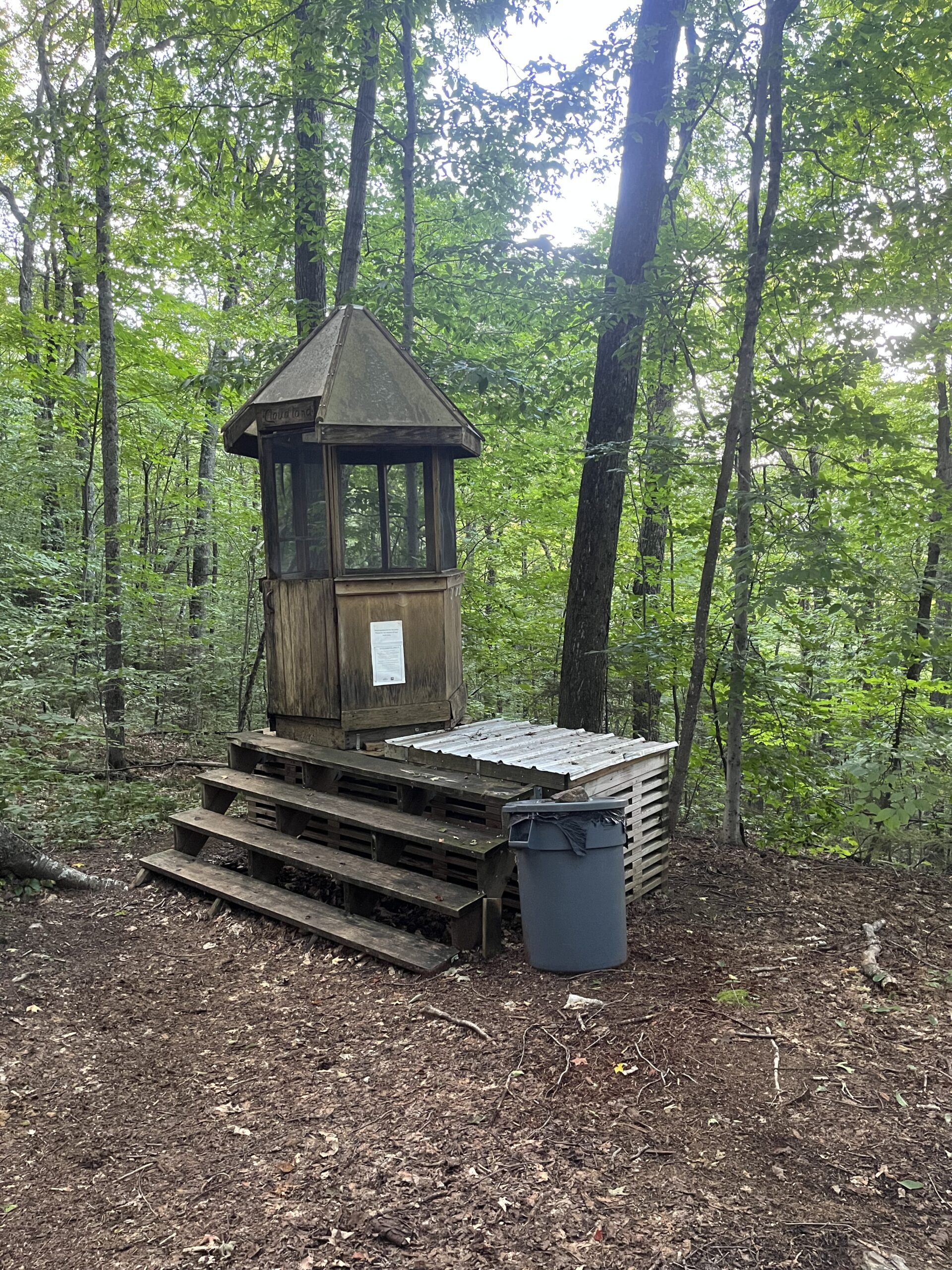
My favorite privy on trail was in VT.
My time in the second half of Vermont was relatively benign. The trail was fairly dry and continued to be pleasantly flat and (mainly) free of rocks and roots. I missed the large storms that had flooded towns and caused the Governor to implement a state emergency to deal with the damage. I made it into Rutland just before the last major storm hit. I was looking forward to this town more than many of the others I had passed through because of a hostel with a famous–or infamous–reputation: the Yellow Deli. This joint restaurant/hostel is run by the religious commune known as the Twelve Tribes. The Twelve Tribes was founded in the 70s in Chattanooga, Tennessee, and now has a worldwide presence. Their beliefs are Christian, but not quite what you’d get at your local church. Considered by many to be a cult, I was especially interested to stay here and feel out the vibes.


Reading material at Yellow Deli
Overall, this experience was positive. The hostel and restaurant were very well-run and had all the amenities a hiker could want. I was asked if I wanted to go back to the Twelve Tribes farm for dinner and to learn more about their community, and politely declined. I was happy enough to get a few days rest and keep moving.
My dad joined me for a small section in VT which was very fun. He got to meet most of my tramily and get a taste of trail life. This was the only time I hiked with friends or family from back home and I’m glad we got to have that shared experience.
Trail Magic Before Crossing into NH
This was my last day in VT, and it was rainy, dreary day. I was hiking by myself to Hanover. As I began crossing the street in West Hartford, I heard a lady calling over to me. It turned out to be the owners of the Blue Barn, a well-known Trail Angel’s house not listed on FarOut. Linda and her husband Randy chain smoke cigarettes on the porch and call over hikers who pass by on the road walk. Randy, who had just finished his night shift, is drinking a bud light at 10 AM. I sit down on their porch with a hot coffee and their cat jumps into my lap. They regale me with stories of past hikers as some of my friends roll up. It was one of my most memorable breaks that turned a rainy day into one of my favorite memories of trail. Here are two normal people who go out of their way to open up their home to hikers even while they go about their lives. I’m continually amazed by the generosity of strangers out here.


Woohoo! New Hampshire!
Entering the Whites
I stayed in Hanover with my friend Meow and his family before making my way towards the Whites. So far New Hampshire hadn’t been that bad, but I didn’t know what was in store for me and my friends.
I soon got my butt kicked by Moosilauke and other mountains early on in NH, but the views made up for the struggle. New Hampshire may be my favorite state on the AT–the hiking and hostels were superb (shoutout to Old Colony Ski Lodge!).

Airing out at the summit of Moosilauke


As an ADK 46er, I have a penchant for hiking mountains over 4,000 feet, and realized that nearly half of the 4000-footers in NH cross over or near the AT. I decided to hike over all of these–which I would come to regret not soon after making this decision.

Franconia Ridge

Ethan Pond

Getting lost in the Presidentials
When I was hiking up Mt. Washington at the beginning of the day, I scoffed at this sign:


We’re all seasoned hiking veterans at this point–what could be so hard about these mountains? Sure they’re steep, but it can’t be that bad. Turns out the sign is right–this was easily the most dangerous day I had on trail.
The day started off normally, with a bit of fog and rain. About halfway through the day the fog cleared and we were treated to some of the most stunning views on the trail.


Continuing my new goal of hitting all the 4000-footers near trail, I passed over all the peaks in the Presidentials, including some blue blazes. Some of my friends joined me, and this added a fair bit of time to the day. By the time we were hiking up Madison, the last peak in the Presidential Range, there were only a few hours of daylight left. It was foggy at the peak, and there was only a small cairn marking the summit. Once there we noticed another cairn a bit further down to the left, and figured that was the trail. Little did we know that just over the peak was another cairn hidden by fog marking the actual AT. Only after descending a steep 500 feet did we realize we took a wrong turn. By this point the weather had turned. It was around 50 degrees, 15-20mph wind gusts, very foggy, rainy, and beginning to get dark. Perfect conditions for hypothermia. We were still above the treeline for at least a mile, meaning that we didn’t have anywhere to safely set up camp until we got down into the forest. Cue panic.
It was at this point that I was very glad to be hiking with a group. Being able to talk out the situation with others was key to keeping me calm. Our options were to continue down the wrong trail until we got below treeline, and try to set up camp somewhere, but with 6 of us in the group there likely wouldn’t be emergency sites for all of us for miles, and we didn’t have information for that section on FarOut. There wasn’t any direct path back to trail from where we were, and the indirect route would likely keep us above treeline in very difficult hiking conditions until after dark. We could cut through the talus field and try to find the trail, but this seemed especially dangerous. In the end, we decided on the safest but least-pleasant option: hike back up Madison the way we came and descend on the AT.
Once we got back up to the summit, we started moving exhaustedly back down the trail. The slippery talus field resulted in a lot of slips and falls. I fell off a boulder and my shin got caught between two rocks. Luckily, I only got a bad scrape. It’s easy to imagine a scenario where I broke my leg here, and I’m grateful that I was able to get back up and keep hiking. Slowly we made it back to the trees–the happiest I’ve been to see those green things. But our day wasn’t over yet.
A small clearing just below the trees had been filled in with other hikers seeking shelter, so we were forced to continue our hike to Osgood campsite, another 2.8 miles and 2500 feet of descent–nearly 1,000 feet per mile (very, very steep). At this point the sun had set. We broke out our headlamps and continued very slowly down the mountain in the dark. Thankful to be out of the wind and rain, we took our time and made sure to get down as safely as possible. At Osgood, I haphazardly set up my hammock and immediately went to sleep.
Looking back on this day, I’m not sure what I would’ve done if I’d been alone. I definitely would’ve been much more scared and prone to make an unsafe choice. It tested my decision making, and I’ll look at conditions and timing much more closely in the future to avoid another close call like this. Hiking in a group–and sticking together–was a major reason why I was able to get down safely. In different circumstances, this situation could’ve ended my hike, or worse. At the summit of Mt. Washington, there is a plaque that lists all of the hikers who have died in the Whites. It’s over a hundred people, going all the way up to 2023. I’m sure more will be added. Don’t take hiking here lightly.

A view of the White Mountains covered in clouds near the NH/ME state line. The weather there changes rapidly–be prepared.
Maine
I got so lucky going through the final state on the AT. After the rainiest summer ever in the Whites we were treated to some beautiful days in Maine, especially the Hundred-Mile Wilderness. It was a cap on an amazing hike. I’m going to let pictures do most of the talking here, but I have almost exclusively fond memories of this section of trail. From campsites next to lakes, loons calling at night, and challenging yet rewarding trail, I would hike it again in a heartbeat.


Crawling through Mahoosuc Notch

Some of my favorite hostel stays and favorite scenery were part of this section. Maine Roadhouse and Shaw’s were both amazing, and we summited the Baldpate mountains on a beautiful day. In some places, you could see both the White Mountains and Katahdin. Getting the views of the finish line changed my mindset and made me realize that I was in the home stretch–this adventure really was coming to a close.

Katahdin from afar.


Summit Day
On my final day on trail, my primary emotion was excitement. It was another typical overcast and foggy day, but everyone was in good spirits. No view from the summit, but we were satisfied with the pictures at the summit sign. Finishing felt a bit anticlimactic. I think it may be that I needed some time to process, which I talk about in my next post.

How many hikers can you fit in the bed of a pickup truck?


After finishing the trail, I got my last hitch into Millinocket and took a flight home the next day. And then began the next chapter in my life!

This website contains affiliate links, which means The Trek may receive a percentage of any product or service you purchase using the links in the articles or advertisements. The buyer pays the same price as they would otherwise, and your purchase helps to support The Trek's ongoing goal to serve you quality backpacking advice and information. Thanks for your support!
To learn more, please visit the About This Site page.
