 ">
">
Week 7: Onward to TN & NC!
Damascus > Bald Mountain Shelter
Days 43-49
Week 7 AT miles: 144.8
Total AT miles: 704.5
I crossed out of Virginia just a few miles into Week 7 and have since been bouncing from state to state along the border between Tennessee and North Carolina. This week included my longest and shortest days yet, as well as the return to some wintry conditions.

A bit of fresh snow and frost
Day 43: Damascus > Iron Mountain Shelter
26.5 AT miles (5948 ft up, 3776 ft down)
I passed two NOBO thru-hikers within the first couple of hours after leaving Damascus, which seemed to confirm my idea to take it easy last week and enjoy the last of my solitude. Including the first suspected NOBO I passed on my day out of Marion, whom today’s hikers were able to identify, my total is now at four. I’m sure I’ll lose count soon but they’re still a delightful surprise after over a month alone on the trail.
Picking the mileage back up felt really good. I was amazed that I was still feeling good at mile 26. That was probably at least in part because of relatively little descent, which is the hardest on feet and knees. After the climb up from Damascus, I just cruised along the ridge the whole day. The trail was very smooth and rolling, with lots of quick ups, downs, and turns. The type of trail I pictured when I heard of “The Rollercoaster.”
The trail also cut back and forth between the sunny leeward side of the ridge and the shady windward side. One side was warm and completely dry, the other chilly and still covered in a thin layer of snow. I was constantly pushing up my sleeves and pulling them back down with the changes in temperature.
I saw two headlamps at a campsite about 1.5 miles before the shelter and figured they were the two thru-hikers I’d been told I’d meet next. Total up to 6, with 4 in one day!
I’d been spoiled by the lovely shelters in Virginia and so found this first shelter in Tennessee rather rustic with its lack of privy and roof too low to stand under. Like I said, spoiled! I still didn’t need to set up my tent, you know, like actual camping. And on the bright side, I’d been meaning to try to get in the habit of doing more of my camp chores while seated to rest my feet and was now forced to do so.

Lovely trail to start the week
Day 44: Iron Mountain Shelter > South end of Watauga Lake
16.2 AT miles (2316 ft up, 4327 ft down)
In addition to being spoiled by the nice shelters, I was spoiled by a stretch of warmer nights. I’d gotten out of practice with the low 20s and didn’t heat any water beyond the nighttime hot water bottle I put at my feet, which is also my morning tea. When I collected water at the first source I passed, as I’d been doing recent mornings, my Aquamira was frozen (obviously). It wasn’t a big deal since I just hiked with it in my sports bra until it melted and I could purify the water, but I still felt a bit incompetent.
The trail continued to be a pleasure to walk and today traced along Watauga Lake, crossing over the dam at one end. The photo below is actually from Day 45, since I somehow managed to admire the lake for several hours without taking a picture of it.
After only one night out I certainly didn’t need another hostel stop, but Boots Off was on my list of must-stays based on recommendations from other hikers. I had missed the other two on that list (Woods Hole and Bear Garden) due to logistics so didn’t want to pass this one by. It was very peaceful as I was again the only guest and seemed like a fun place to hang out once the season gets going.
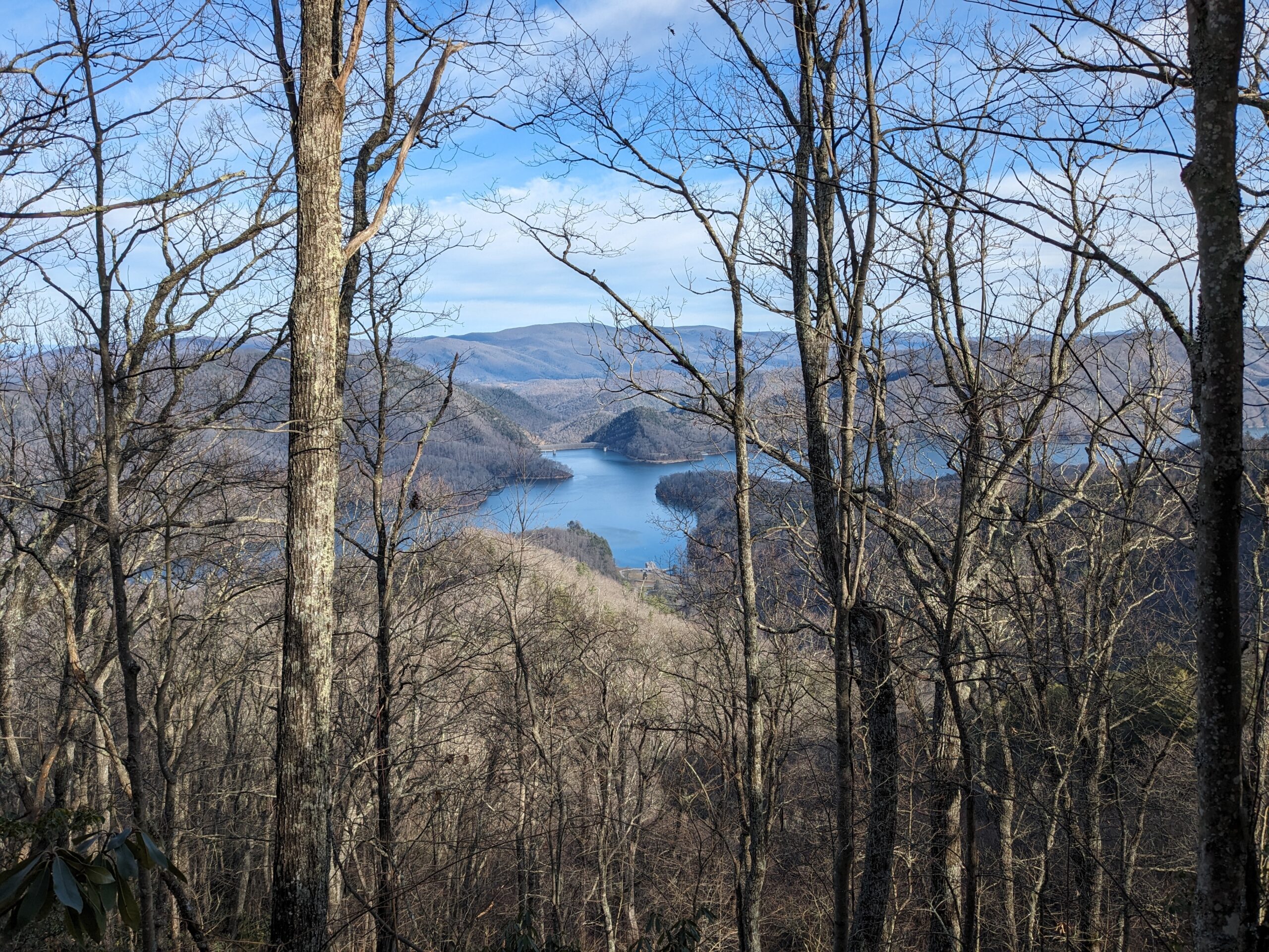
Watauga Lake
Day 45: South end of Watauga Lake > Mountaineer Falls Shelter
24.9 AT miles (6542 ft up, 5453 ft down)
Best day yet on the AT!
Both the weather and the scenery were unbelievably gorgeous. Beautiful lake views. A dramatic waterfall. Smooth trail along a shady, crystal clear stream. Sparkling sunshine. A nice breeze. Volunteers on their way to clear a blowdown. Friendly local hikers pointing me toward their favorite spot. I can’t imagine a better day on the Appalachian Trail.
Well-rested and well-caffeinated thanks to Boots Off, I flew up the smooth steady climb from Watauga Lake, gaining 1750 feet over 3 miles. I kept getting what I thought would be my last view of the lake, then get another vista from higher up. One of the joys of hiking before the trees have leaves.
I ran into two volunteers from Tennessee Eastman Hiking and Canoeing Club who were hiking up from Laurel Fork with their long two-person crosscut saw to clear a blowdown in the wilderness area, where chainsaws aren’t allowed. One said that she had seen the downed tree on a hike yesterday. I was amazed at how on quick they were to respond and happy to be able to thank some trail volunteers directly.
Not long after, I crossed paths with NOBO #7. It was cool to be part of the hiker grapevine and be able to answer his questions about which hikers were how many days ahead. I’m sure the volume of NOBOs will soon exceed my ability to keep track of them, but for the moment, I’m a human trail register.
Joining up with the Laurel Falls trail, I enjoyed the type of wide, perfectly smooth trail that you only get when the AT coincides for a while with a beloved local trail. I always make sure in those cases to check my map right away to see where we part ways because, if not paying close attention, my subconscious will want to keep following the nice trail and miss the turn-off onto the more rugged AT.
Climbing up steep stone steps from Laurel Falls (the only unpleasant bit of today’s hike), I met some local hikers who recommend a short side trail up to Potato Top. I couldn’t pass up a spot they described as their “happy place” so made a quick dash up the extra 500 feet. I ditched my pack halfway up and was amazed at how, between my legs and my trekking poles, I felt like I was being flung up the mountain, such was the difference in force required to lift me without the extra weight.

Sunny walk along a beautiful creek
Day 46: Mountaineer Falls Shelter > Roan High Knob Shelter
25.1 AT miles (7730 ft up, 4636 ft down)
Today was a day of contrasts and totally kicked my butt. Partly because of the 7700 feet of elevation gain and partly because I’d grown accustomed to all that nice trail. Today started off pretty smoothly but the middle third had all the slow stuff: snow covered rocks, high steps, lumpy meadows, mud. And the last mile and a half, when I thought I was minutes away from bed, was covered in ice.
A big highlight today was spotting a species I’d never seen before. I could have sworn it was an American pine marten (Martes americana), but looking now at their known range, it seems more likely to have been a fischer (Pekania pennanti). Although, honestly, I’m switching back and forth between photos of the two and none of the fischer photos are as red as what I saw or have the white patch near the face. Also, in my highly scientific opinion, this little pumpkin was a lot cuter than a fischer. Maybe the martens aren’t quite extirpated after all?
After a grey gloomy day, I got to enjoy a beautiful pastel sunset from atop Round Bald, a summit in the Roan Highlands. My frozen-fingered photo doesn’t come close to doing it justice, but it was one of the most beautiful sunsets I’ve experienced on trail, with layers of ridges and clouds visible in every direction. In these spectacular moments, I wish I could bundle up my loved ones (it was 15 degree windchill with occasional 40mph gusts) and teleport them onto the bald with me to witness the breathtaking beauty.

Roan Mountain at sunset
Day 47: Roan High Knob Shelter > Curley Maple Gap Shelter
30.9 AT miles (6030 ft up, 9236 ft down)
My first 30 mile day!
I have in my notes that 20 degrees felt cold this morning after such a long break with warmer lows. However, I can see now as I paste the days together that I thought more or less the same thing three days ago. Apparently I forget the less pleasant aspects of the hike very quickly, so I guess you should assume a nice helping of rose-colored bias in reading these posts.
I do remember that, although my boots were fortunately dry enough not to freeze, the soles were frozen to the floor of the shelter, which was a first. They came loose easily enough and I bundled up to brave the low single-digit windchill and horizontal snow.
The forest this morning atop Roan Mountain felt truly enchanted. I didn’t dare stop and remove my glove + 2 mitten combo to use my phone, but being unable to take a photo forced me to fix the scene in my mind in a way I haven’t tried in a while. The fir and spruce needles were each frosted white, the ground was covered in snow, and the reddish trunks and lime green moss seemed to glow in the early morning light.
As I descended, I found bare broadleaf forests similarly frosted, their trails thankfully less icy. By day’s end I’d left the snow behind altogether and spent the night at a shelter over 3000 feet below Roan High Knob, the highest on the Appalachian Trail at 6270 feet.
The day’s overall descent of 9000+ feet had given me pause when deciding to attempt this itinerary, and I was definitely feeling it during those last few miles downhill on rocky trail.
I wondered at the time how it compared to the South Kaibab Trail down to the Colorado River in the Grand Canyon, which is my most vivid memory of an endless descent. Fortunately I didn’t have cell service at the time, but checking just now I see that the South Kaibab descends just shy of 5000 feet. It’s obviously different to do it all at once versus spread out over 30 miles but still provides an interesting perspective on how the smaller elevation changes of the AT really add up.

View as I descended below the clouds
Day 48: Curley Maple Gap Shelter > Nolichucky River (Erwin)
4.1 AT miles (167 ft up, 1535 ft down) + 2 bonus miles to the supermarket
From my longest day to my shortest!
I’d originally planned the long day yesterday so I could easily hike into Erwin, resupply, and hike onward to the next shelter. When a friend in Johnson City invited me to come stay, I decided to still try for the 30-mile day to give us more time to catch up. I also just thought it seemed like a fun milestone to reach.
I had a wonderful afternoon and evening hanging out with my friend and her kitties, getting myself and my clothes clean, and meeting up with her boyfriend at my favorite Mexican restaurant from our nursing school days.

The sweet kitties I visited in Johnson City (along with my human friend of course)
Day 49: Nolichucky River > Bald Mountain Shelter
17 AT miles (6158 ft up, 2776 ft down)
I had a wonderfully lazy morning at my friend’s house, packing up slowly and giving the kitties some last scritches. After a ride back to the trail, I finally started walking again by crossing the Nolichucky around 10:45.
It had been a long descent from Beauty Spot down to the river over the previous two days, so I wasn’t surprised that today’s hike began with a long climb back up onto the ridge. Fortunately, the trail was very nicely graded with lots of beautiful switchbacks through the pines and rhododendra.
Today was another day when I could really appreciate the contrast between the sunny slopes and the shaded slopes. In the sun, there was no sign of the snow whatsoever, just brown leaves on the ground and green rhododendra lining the trail. Then I’d go around a bend and everything was still covered in a thin layer of snow, with giant icicles hanging from some of the logs and rocks.
As I approached the shelter shortly after dark, I was surprised to find another hiker. My second time since Harpers Ferry sharing a shelter!

Snow lingering in the shade

This website contains affiliate links, which means The Trek may receive a percentage of any product or service you purchase using the links in the articles or advertisements. The buyer pays the same price as they would otherwise, and your purchase helps to support The Trek's ongoing goal to serve you quality backpacking advice and information. Thanks for your support!
To learn more, please visit the About This Site page.

Comments 4
Thanks for providing some double weekend reading! The end there sounds like a cliffhanger hehe! And glad you got to see a buddy from Johnson City 🙂
My zero day in Hot Springs helped me catch up a bit. 🙂
I am very much enjoying your descriptions of the trail and how you are enjoying your time along it – thank you very much for putting the effort into these posts, and I look forward to more of them.
Thanks, that’s very kind! For years I’ve wanted to record my adventures in some way, and knowing others are following along is helping me stick with it this time, even if I do keep falling behind.