 ">
">
Why You Should Start the AT at Flagg Mountain Instead of Springer
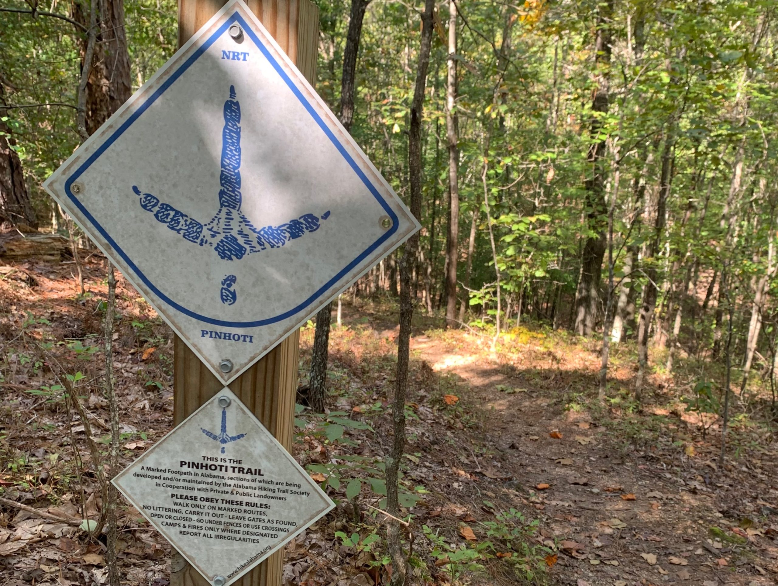
In the following essay, I will make the case as to why you should start your Appalachian Trail thru-hike in Alabama by appealing to the purist, the novice, and the challenger. But first, let me start by sharing that Flagg Mountain, near the small town of Weogufka in the center of Alabama, is recognized as the southernmost mountain over 1000ft in the Appalachian Mountain range and thus marks the beginning of the Appalachians. It is also the Southern Terminus of the Pinhoti Trail, an Appalachian Trail connector trail, which was joined with the Georgia Pinhoti section in 2008.

Appeal to the Purist
If you consider yourself a purist and want to walk the entire Appalachian mountain range, then you’re looking at international travel because the mountains don’t start at Springer and don’t stop at Katahdin, nor do they abruptly end at the border with Canada. The range continues on into Newfoundland and Labrador and leads you till you cannot go any further, stopped by the Atlantic Ocean.
But wait, the range doesn’t stop there: it goes beyond North America. If that blows your mind, then you probably weren’t paying attention in science class. So if you would allow me to give a brief crash course…a billion years ago, present day Scotland was cozied up against what is now the north-east US and Canada. Fast forward to 400 million years ago when the ancient continents collided to form the Caledonian Mountains. Then around 50 million years ago the landmasses separated and split up the mountain chain. The remains of that range are the Appalachian Mountains in North America, but the remaining chain stretches all the way to Norway.
Therefore, the International Appalachian Trail has recognized sections in Scotland, Greenland, etc. So before you get overwhelmed as to how you’re going to fly to Greenland to hike, I’ve got a much more easily accessible portion of the mountain range for you. That’s right: it’s the 350 miles along the Pinhoti Trail in Alabama and Georgia. So if you want to claim you hiked the whole Appalachian mountain range (in the United States) then you need to start at the beginning, on Flagg Mountain.
Appeal to the Novice
The first section of the AT in North Georgia is not exactly an easy start for a novice backpacker. Your pack is probably too heavy with unnecessary items like bear spray, deodorant, and perhaps even a machete. Your trail runners aren’t broken in and you may or may not have set up your rain fly inside out and snapped your tent poles on the second night out.
So why not ease into your thru-hike with what I like to call “AT Lite” or the “approach-approach trail,” a.k.a. The Pinhoti Trail. You’ll start off with smaller mountains in Alabama that will progressively get bigger the closer you get to Springer, acting as a natural progression and a good warmup in acquiring your trail legs.
It’s not a difficult trail to follow, and FarOut even has a guide. There are a sprinkling of hostels along the way, a few shelters, and resupply options such as Dollar General right along the path. You can even get your picture with the mayor of Heflin if that is something you wanted to do. If you were looking to do a shakedown hike, this could be it, and by the time you hit the white blazes, you won’t be a novice anymore.

Appeal to the Challenger
In a time when trail culture keeps upping the anty with FKTs, calendar year triple crowns, yo-yos, four-state challenges, etc., why not tack on another 400 or so miles to your AT thru-hike? What’s another few weeks on top of your four-month trek? Did I mention that it’s easy terrain for the most part, so you should be able to fly through? Sure, it might have 50+ miles of road walks and notorious areas known as the gauntlet—wherein you must practice stealth and agility while passing unleashed and aggressive dogs—but that just adds to the challenge, doesn’t it?
Am I there yet?
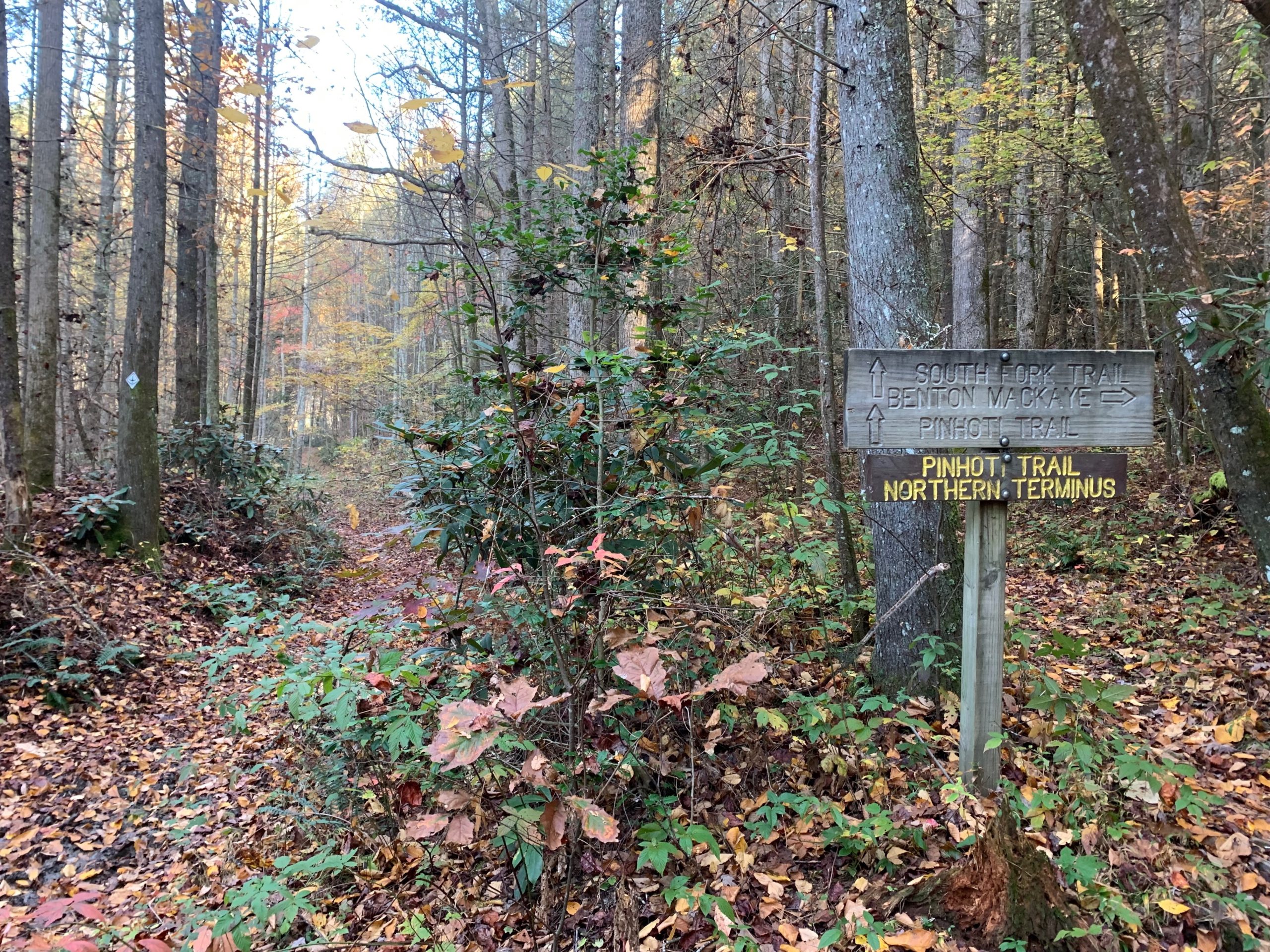
Now, if you’ve looked at a map, you might notice that the Pinhoti doesn’t exactly end at Springer. The northern terminus lies unceremoniously in the middle of the woods at the intersection with the Benton MacKaye Trail just ten miles south of the Tennessee line. So to get to Springer, you’d have to hike southbound on the BMT for another 70 miles to get to Springer. Or you could continue Northbound on the BMT and jump on the AT at Fontana Dam, where the trails cross. But hey, the AT wouldn’t exist if it wasn’t for Benton, so show your respect and hike the trail named for him. (Plus it’s actually his original route for the AT.)
Looking Forward
Making the Pinhoti Trail part of the official AT is out of my hands. I can’t magically wave my spork and create the protected footpath with the flick of my wrist. That’s something the ATC would have to work on. And if it’s anything like what they’ve had to go through over the past several decades acquiring lands for the trail and corridor, then it will not be easy. It might not even be possible, for that matter. I imagine the Alabama portion would probably be easier to add since the majority of the trail lies within Talledega National Forest, but as for Georgia, that’s when you have serious road walks through towns and the city of Dalton.
I’m from Alabama, so I’m probably a little biased, but I’d love to see the Appalachian Trail extended to Flagg Mountain. I’m proud and privileged to have a protected long trail in my home state, and I just want more people to be able to witness the beauty of Cheaha Wilderness, the looming Long Leaf Pines, and the never-ending rhododendron tunnels. So let’s get on that, shall we?

Featured image: Graphic design by Jillian Verner (@yourstrulyjillian).

This website contains affiliate links, which means The Trek may receive a percentage of any product or service you purchase using the links in the articles or advertisements. The buyer pays the same price as they would otherwise, and your purchase helps to support The Trek's ongoing goal to serve you quality backpacking advice and information. Thanks for your support!
To learn more, please visit the About This Site page.

Comments 12
I like it gulf state to bay of Fundy you’ll have hundreds of AT completers come do that section
I hiked the Pinhoti in Dec, and while I agree with your reasons for people to start there (or just to hike it, its a wonderful trail!), I have one big reason why for some people it might not be an ideal place to start. It is a very, very empty trail. Which can be great. And also, kinda rough. Especially if it is you are going solo, and/or doing your first thru hike (both if which I was). In the 20 days I hiked, I came across 7 other people in three groups on trail, all headed SOBO while I was NOBO, so probably about a half hour of actual human interaction outside of towns the whole trip. I am pretty content with my own company, obviously I wouldn’t have done a trip like that solo if I wasn’t, and I didn’t expect crowds. But it was a lot of alone, even for me.
Its something for newbie thru hikers to consider before choosing to start here. While the lovely rolling hills, gorgeous views, and easy access to towns for resupply made it great for a first thru hiking attempt, you do lose the camaraderie and shared sense of purpose that people getting started on more trafficked trails have to bolster their spirits, as well as the opportunity to talk to others who can relate to the new challenges and experiences they are facing.
Good point Melissa! I guess for all the folks wanting to avoid crowds then it would be good, but for hikers that want more camaraderie then they’ll just have to know going into it that they won’t see many people. Congrats on your hike!
Hi Tide,
I live in Opelika and thru hiked the AT in 2019. My bucket list includes thru hike of the Pinhoti and rowing the Mississippi from source to sea. What part of Alabama are you from?
War Eagle and Happy Trails!
Chappy Jack
Hi Chappy Jack! Congrats on your thru-hike! You’ll love the Pinhoti Trail! However, you might want to check out my YouTube videos of my MS River source to sea before you head to Lake Itasca, haha, I didn’t love that trip. But anyways, I’m from just outside of Huntsville. Roll Tide!
I highly recommend the Mississippi trip. Rowing might not be the best choice? I paddled. Many kayak. It would be hard from Lake Itasca to lake Bemidji. After that the river is wide enough for oars. What sort of boat would you row?
I would recommend you gather the opinions of the Flagg Mt. and Pinhoti folks. If you went to the trouble to do that, you would find they have no such interest (& frankly, I don’t blame them).
It is its own trail, & I’ll defer to the experts and their wishes for the trail they love & support.
Awesome post. I have a feeling you just started a movement. Very nice.
Thank you! I am glad you enjoyed it.
If geology is your guide, maybe you should start at Tannehill State Park in Alabama, but you’ll have to do a lot of road walking.
Wait why would you bring bear spray or a machete? That’s dumb. This isn’t the Northern Rockies and you’re hiking not building a homestead or harvesting bananas.
The trail has to start and end somewhere. I thru-hiked in 1998 and when I finally climbed Katahdin, didn’t I want to take the Knife Edge on the other side all the way to the Gaspy peninsula in Canada? I wanted to keep hiking forever with the people I met along the way.
The other thing I would be concerned about is the heat. Most NOBOs start in early spring so you end in early fall. Experiencing 90° temps in summer thru NY , Connecticut, and Massachusetts was bad enough, thanks.
Ps: I totally loved my thru-hike as it was and am still good friends with my group that we all met along the way.